Report on Bogoslof (United States) — 25 January-31 January 2017
Smithsonian Institution / US Geological Survey
Weekly Volcanic Activity Report, 25 January-31 January 2017
Managing Editor: Sally Sennert.
Please cite this report as:
Global Volcanism Program, 2017. Report on Bogoslof (United States) (Sennert, S, ed.). Weekly Volcanic Activity Report, 25 January-31 January 2017. Smithsonian Institution and US Geological Survey.
Bogoslof
United States
53.93°N, 168.03°W; summit elev. 150 m
All times are local (unless otherwise noted)
AVO reported that no further emissions were detected at Bogoslof after an explosion at 0453 on 24 January; the Aviation Color Code (ACC) was lowered to Orange and the Volcano Alert Level (VAL) was lowered to Watch the next day. An hour-long seismic increase began at 0134 on 25 January though no evidence of eruptive activity was evident. Based on lightning and seismic data an explosive event began at 0650 on 26 January, and another burst of seismicity was recorded at 0706. The ACC was raised to Red and the VAL was raised to Warning. An ice-rich cloud, first identified in satellite data at 0700, likely contained ash, and rose as high as 9.8 km (32,000 ft) a.s.l. and drifted SE at lower altitudes, and NE at altitudes above about 6.1 km (20,000 ft) a.s.l. The ACC was lowered to Orange and the VAL was lowered to Watch later that day. Lightning and seismic data again indicated an explosive event at 0824 on 27 January, prompting AVO to raise the Aviation Color Code (ACC) to Red and the Volcano Alert Level (VAL) to Warning. An ice-rich cloud that likely contained ash rose to an altitude of 7.6 km (25,000 ft) a.s.l. and drifted E; seismicity related to ash emissions remained elevated for 48 minutes. The ACC was lowered to Orange and the VAL was lowered to Watch later that day.
Several short bursts of seismic activity were detected at 0520 and 0608 on 30 January. An infrasound signal accompanied the first event indicating an explosion; an eruption cloud was identified in satellite data at 0530, rising to an altitude of 6.1 km (20,000 ft) a.s.l. later that day AVO noted that bursts of explosive activity continued and intensified; more than 10 short-duration explosions were detected in seismic, infrasound, and lightning data. The Aviation Color Code (ACC) was raised to Red and the Volcano Alert Level (VAL) was raised to Warning. Ash plumes rose as high as 7.6 km (25,000 ft) a.s.l. and drifted 125 km SE. Trace amounts of ashfall and a sulfur odor were reported in Unalaska/Dutch Harbor (98 km E). By the next day the explosions had subsided or ended. Satellite images acquired on 31 January showed significant changes to the island. AVO stated that freshly erupted volcanic rock and ash had formed a barrier that separated the vent from the sea, suggesting that the change had resulted in the more ash-rich emissions occurring during 30-31 January.
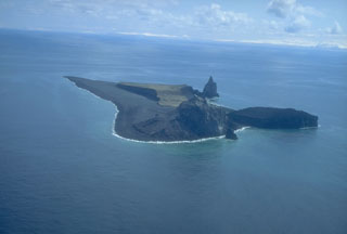
Geological Summary. Bogoslof is the emergent summit of a submarine volcano that lies 40 km N of the main Aleutian arc. It rises 1,500 m above the Bering Sea floor. Repeated construction and destruction of lava domes at different locations during historical time has greatly modified the appearance of this "Jack-in-the-Box" volcano and has introduced a confusing nomenclature applied during frequent visits by exploring expeditions. The present triangular-shaped, 0.75 x 2 km island consists of remnants of lava domes emplaced from 1796 to 1992. Castle Rock (Old Bogoslof) is a steep-sided pinnacle that is a remnant of a spine from the 1796 eruption. The small Fire Island (New Bogoslof), about 600 m NW of Bogoslof Island, is a remnant of a lava dome formed in 1883.
Source: US Geological Survey Alaska Volcano Observatory (AVO)

