Report on Cerro Azul (Ecuador) — 22 March-28 March 2017
Smithsonian Institution / US Geological Survey
Weekly Volcanic Activity Report, 22 March-28 March 2017
Managing Editor: Sally Sennert.
Please cite this report as:
Global Volcanism Program, 2017. Report on Cerro Azul (Ecuador) (Sennert, S, ed.). Weekly Volcanic Activity Report, 22 March-28 March 2017. Smithsonian Institution and US Geological Survey.
Cerro Azul
Ecuador
0.92°S, 91.408°W; summit elev. 1640 m
All times are local (unless otherwise noted)
IG reported that increased seismicity at Cerro Azul began on 15 February and was characterized by the presence of volcano-tectonic events. A 1-hour-long swarm occurred the next day, and then afterwards only sporadic events were detected, some of which were located in the Sierra Negra volcano region. Sporadic events located at Sierra Negra continued to be detected during 8-13 March. A 30-minute-long swarm was recorded on 18 March. Earthquakes became more frequent and intense on 19 March, and another swarm occurred during 0700-1800 on 20 March; earthquake locations migrated SW, to the SE part of Cerro Azul during 19-20 March. Another swarm was detected during 1915-2200 on 21 March, with most magnitudes between 2.4 and 3, though the highest was 3.6.
Deformation during 8-20 March was detected in satellite data, characterized by 14 cm of inflation at the SE flank and 11.2 cm of deflation at the summit. Deformation and seismic data suggested the emplacement of a sill 3.5-6.3 km below the SE flank.
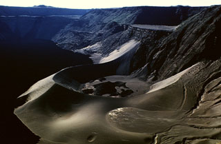
Geological Summary. Located at the SW tip of the J-shaped Isabela Island, Cerro Azul contains a steep-walled 4 x 5 km nested summit caldera complex that is one of the smallest diameter, but at 650 m one of the deepest in the Galápagos Islands. The shield volcano is the second highest of the archipelago. A conspicuous bench occupies the SW and west sides of the caldera, which formed during several episodes of collapse. Youthful lava flows cover much of the caldera floor, which has also contained ephemeral lakes. A prominent tuff cone located at the ENE side of the caldera is evidence of episodic hydrovolcanism. Numerous spatter cones dot the western flanks. Fresh-looking lava flows, many erupted from circumferential fissures, descend the NE and NW flanks. Historical eruptions date back only to 1932, but Cerro Azul has been one of the most active Galápagos volcanoes since that time. Solfataric activity continues within the caldera.
Source: Instituto Geofísico-Escuela Politécnica Nacional (IG-EPN)