Report on Kadovar (Papua New Guinea) — 10 January-16 January 2018
Smithsonian Institution / US Geological Survey
Weekly Volcanic Activity Report, 10 January-16 January 2018
Managing Editor: Sally Sennert.
Please cite this report as:
Global Volcanism Program, 2018. Report on Kadovar (Papua New Guinea) (Sennert, S, ed.). Weekly Volcanic Activity Report, 10 January-16 January 2018. Smithsonian Institution and US Geological Survey.
Kadovar
Papua New Guinea
3.608°S, 144.588°E; summit elev. 365 m
All times are local (unless otherwise noted)
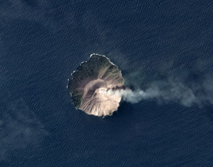
According to Brandon Buser, just after eruption plumes started rising from a vent on the SE side of Kadovar on 5 January boats from a village on the mainland (22 km SW) and from Bam (25 km E) were sent to the island to evacuate residents. The entire population of the island (about 500 people according to a news article citing the Red Cross) was evacuated by the boats and numerous canoes to Blup Blup (15 km N). Activity escalated around midnight. The next day, at a distance of 65 km, Buser and others saw ash emissions rising from Kadovar, and at about 24 km away from the island they experienced ashfall. As they were circling the island a large event sent a large plume hundreds of feet into the air and ejected large boulders into the ocean. During another visit on 8 January Buser noted two new eruptive vents, ashfall covering everything on the village side, and wet falling ash.
RVO reported that activity significantly escalated on 12 January characterized by a large blast of a substantial amount of material and “big” glowing red rocks directed to the S; the report noted that the blast was the only one reported to date. Observers on Blup Blup saw incandescence emanating from either the summit or an area out of view on the S flank. Large amounts of sulfur dioxide had been detected since 8 January, and continued to be emitted. A fracture had previously been reported on 6 January extending from the summit to the coast. When seen on 12 January, the fracture was wider and vigorous steaming was occurring at sea level. Ash plumes drifted tens of kilometers W and NW. RVO noted that the displaced villagers were getting transferred to the mainland, along with islanders from Bam, due to the relatively close proximity to the eruption plus the logistics of supplying them.
Five newly-named vents were observed during an overflight conducted on 13 January: Main Crater, Western vent, and Southern vent (all three are at the summit), the SE Coastal vent, and the Southern Coastal vent. Sometimes voluminous steam and dense gray plumes rose 1 km above the Main Crater. The emissions obscured views of Southern and Western vents. The SE Coastal Vent was very active, emitting dense white steam plumes 600 m a.s.l. A possible lava dome was at the base of the plumes but showed no evidence of incandescence. The Southern Coastal Vent, located where the original fractures entered the sea, was inactive.
Geological Summary. The 2-km-wide island of Kadovar is the emergent summit of a Bismarck Sea stratovolcano of Holocene age. It is part of the Schouten Islands, and lies off the coast of New Guinea, about 25 km N of the mouth of the Sepik River. Prior to an eruption that began in 2018, a lava dome formed the high point of the andesitic volcano, filling an arcuate landslide scarp open to the south; submarine debris-avalanche deposits occur in that direction. Thick lava flows with columnar jointing forms low cliffs along the coast. The youthful island lacks fringing or offshore reefs. A period of heightened thermal phenomena took place in 1976. An eruption began in January 2018 that included lava effusion from vents at the summit and at the E coast.
Sources: Rabaul Volcano Observatory (RVO), BBC News, Brandon Buser