Report on Lascar (Chile) — 4 April-10 April 2018
Smithsonian Institution / US Geological Survey
Weekly Volcanic Activity Report, 4 April-10 April 2018
Managing Editor: Sally Sennert.
Please cite this report as:
Global Volcanism Program, 2018. Report on Lascar (Chile) (Sennert, S, ed.). Weekly Volcanic Activity Report, 4 April-10 April 2018. Smithsonian Institution and US Geological Survey.
Lascar
Chile
23.37°S, 67.73°W; summit elev. 5592 m
All times are local (unless otherwise noted)
OVDAS-SERNAGEOMIN reported that, although seismicity at Láscar during March was low, characteristics of the signals were similar to patterns observed prior to previous minor phreatic explosions, particularly before events in 2013 and 2015. The Alert Level was raised to Yellow (second highest level on a four-color scale); SERNAGEOMIN recommended no entry into a restricted area within 5 km of the crater. ONEMI declared an Alert Level Yellow (the middle level on a three-color scale) for San Pedro de Atacama.
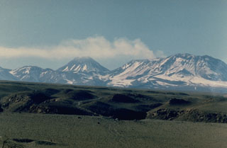
Geological Summary. Láscar is the most active volcano of the northern Chilean Andes. The andesitic-to-dacitic stratovolcano contains six overlapping summit craters. Prominent lava flows descend its NW flanks. An older, higher stratovolcano 5 km E, Volcán Aguas Calientes, displays a well-developed summit crater and a probable Holocene lava flow near its summit (de Silva and Francis, 1991). Láscar consists of two major edifices; activity began at the eastern volcano and then shifted to the western cone. The largest eruption took place about 26,500 years ago, and following the eruption of the Tumbres scoria flow about 9000 years ago, activity shifted back to the eastern edifice, where three overlapping craters were formed. Frequent small-to-moderate explosive eruptions have been recorded since the mid-19th century, along with periodic larger eruptions that produced ashfall hundreds of kilometers away. The largest historical eruption took place in 1993, producing pyroclastic flows to 8.5 km NW of the summit and ashfall in Buenos Aires.
Sources: Servicio Nacional de Geología y Minería (SERNAGEOMIN), Oficina Nacional de Emergencia-Ministerio del Interior (ONEMI)

