Report on Makushin (United States) — 15 July-21 July 2020
Smithsonian Institution / US Geological Survey
Weekly Volcanic Activity Report, 15 July-21 July 2020
Managing Editor: Sally Sennert.
Please cite this report as:
Global Volcanism Program, 2020. Report on Makushin (United States) (Sennert, S, ed.). Weekly Volcanic Activity Report, 15 July-21 July 2020. Smithsonian Institution and US Geological Survey.
Makushin
United States
53.891°N, 166.923°W; summit elev. 1800 m
All times are local (unless otherwise noted)
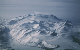
AVO reported that small earthquakes in an area about 10 km E of the Makushin’s summit and at a depth of about 8 km continued to be detected during 15-21 July. Since the onset of seismicity on 15 June, the earthquakes had generally decreased in both size and rate. No surficial activity was visible in satellite or webcam images; only typical minor steaming from the summit crater lake. Weakly elevated surface temperatures were identified in satellite data during 20-21 July. The Aviation Color Code and Volcano Alert Level remained at Yellow and Advisory, respectively.
Geological Summary. The ice-covered Makushin volcano on northern Unalaska Island is capped by a 2.5 km caldera. Its broad, dome-like structure contrasts with the steep-sided profiles of most other Aleutian stratovolcanoes. Much of the edifice was formed during the Pleistocene, but the caldera (which formed about 8,000 years ago), Sugarloaf cone on the ENE flank, and a cluster of about a dozen explosion pits and cinder cones at Point Kadin on the WNW flank, are of Holocene age. A broad band of NE-SW-trending vents cuts across the volcano. The composite Pakushin cone, with multiple summit craters, lies 8 km SW. Table Top (Pleistocene, 68 +/- 14 ka) and Wide Bay (Holocene) cinder cones are about 20 km ENE on the peninsula across the bay from the City of Unalaska. Frequent explosive eruptions have occurred during the past 4,000 years, sometimes accompanied by pyroclastic flows and surges. Geothermal areas are found in the summit caldera and on the SE and E flanks. Small-to-moderate explosive eruptions have been recorded since 1786.
Source: US Geological Survey Alaska Volcano Observatory (AVO)