Report on Kadovar (Papua New Guinea) — 25 August-31 August 2021
Smithsonian Institution / US Geological Survey
Weekly Volcanic Activity Report, 25 August-31 August 2021
Managing Editor: Sally Sennert.
Please cite this report as:
Global Volcanism Program, 2021. Report on Kadovar (Papua New Guinea) (Sennert, S, ed.). Weekly Volcanic Activity Report, 25 August-31 August 2021. Smithsonian Institution and US Geological Survey.
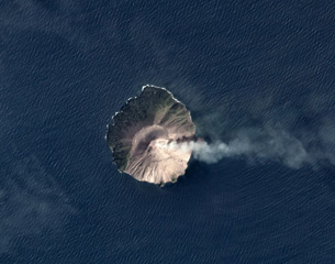
Kadovar
Papua New Guinea
3.608°S, 144.588°E; summit elev. 365 m
All times are local (unless otherwise noted)
Based on satellite and wind model data, the Darwin VAAC reported that on 27 and 30 August ash plumes from Kadovar rose to altitudes of 1.2-1.5 km (4,000-5,000 ft) a.s.l. and drifted W and WNW.
Geological Summary. The 2-km-wide island of Kadovar is the emergent summit of a Bismarck Sea stratovolcano of Holocene age. It is part of the Schouten Islands, and lies off the coast of New Guinea, about 25 km N of the mouth of the Sepik River. Prior to an eruption that began in 2018, a lava dome formed the high point of the andesitic volcano, filling an arcuate landslide scarp open to the south; submarine debris-avalanche deposits occur in that direction. Thick lava flows with columnar jointing forms low cliffs along the coast. The youthful island lacks fringing or offshore reefs. A period of heightened thermal phenomena took place in 1976. An eruption began in January 2018 that included lava effusion from vents at the summit and at the E coast.