
Smithsonian Institution / US Geological Survey
Weekly Volcanic Activity Report, 11 December-17 December 2002
Managing Editor: Gari Mayberry
Please cite this report as:
Global Volcanism Program, 2002. Report on Papandayan (Indonesia) (Mayberry, G, ed.). Weekly Volcanic Activity Report, 11 December-17 December 2002. Smithsonian Institution and US Geological Survey. https://volcano.si.edu/showreport.cfm?gvpvar=GVP.WVAR20021211-263100
During 2-8 December, ash plumes continually emitted from Papandayan's Baru crater rose 150-400 m above the rim and drifted NE. Explosions occurred on 4 December at 0700 and on 8 December at 1758. The number of shallow volcanic earthquakes decreased during the report week, while deep volcanic and tectonic earthquakes increased in comparison to the previous week. Papandayan remained at Alert Level 3 (on a scale of 1-4).
Source: Pusat Vulkanologi dan Mitigasi Bencana Geologi (PVMBG, also known as CVGHM)
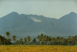
Geological Summary. Papandayan is a complex stratovolcano at the S end of a curved volcanic massif with Kendang volcano ~9 km away at the N end, Gunung Puntang ~3.5 km NNE, and Gunung Jaya ~6 km NNE. Several episodes of collapse have created an irregular profile and produced debris avalanches that have affected lowland areas. The summit area includes four large craters, including the 1.1-km-wide, flat-floored Alun-Alun crater. A sulfur-encrusted fumarole field occupies the active Kawah Mas ("Golden Crater"). The first reported eruption, in 1772 CE, included a collapse of the NE flank and a debris avalanche that destroyed 40 villages and killed almost 3,000 people. Smaller phreatic eruptions occurred during 1923-25, 1942, and 2002.


 Papandayan