
Smithsonian Institution / US Geological Survey
Weekly Volcanic Activity Report, 18 December-24 December 2002
Managing Editor: Gari Mayberry
Please cite this report as:
Global Volcanism Program, 2002. Report on Rabaul (Papua New Guinea) (Mayberry, G, ed.). Weekly Volcanic Activity Report, 18 December-24 December 2002. Smithsonian Institution and US Geological Survey. https://volcano.si.edu/showreport.cfm?gvpvar=GVP.WVAR20021218-252140
During 17-20 December, the eruption of Rabaul volcano's Tavurvur cone was characterized by slow, convoluted ash plumes that rose several hundred to more than a thousand meters above the summit. Seismicity was low to moderate and no significant ground deformation was recorded.
Source: Rabaul Volcano Observatory (RVO) via the Darwin Volcanic Ash Advisory Center
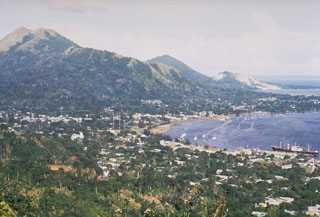
Geological Summary. The low-lying Rabaul caldera on the tip of the Gazelle Peninsula at the NE end of New Britain forms a broad sheltered harbor utilized by what was the island's largest city prior to a major eruption in 1994. The outer flanks of the asymmetrical shield volcano are formed by thick pyroclastic-flow deposits. The 8 x 14 km caldera is widely breached on the east, where its floor is flooded by Blanche Bay and was formed about 1,400 years ago. An earlier caldera-forming eruption about 7,100 years ago is thought to have originated from Tavui caldera, offshore to the north. Three small stratovolcanoes lie outside the N and NE caldera rims. Post-caldera eruptions built basaltic-to-dacitic pyroclastic cones on the caldera floor near the NE and W caldera walls. Several of these, including Vulcan cone, which was formed during a large eruption in 1878, have produced major explosive activity during historical time. A powerful explosive eruption in 1994 occurred simultaneously from Vulcan and Tavurvur volcanoes and forced the temporary abandonment of Rabaul city.


 Rabaul