
Smithsonian Institution / US Geological Survey
Weekly Volcanic Activity Report, 11 January-17 January 2023
Managing Editor: Sally Sennert
Please cite this report as:
Global Volcanism Program, 2023. Report on Krakatau (Indonesia) (Sennert, S, ed.). Weekly Volcanic Activity Report, 11 January-17 January 2023. Smithsonian Institution and US Geological Survey. https://volcano.si.edu/showreport.cfm?gvpvar=GVP.WVAR20230111-262000
PVMBG reported that the eruption at Anak Krakatau continued. At 1754 on 11 January a dense gray ash plume rose around 200 m above the summit and drifted NE, followed by dense black ash plumes at 2241 and 2325 on 11 January and at 0046 on 12 January that rose 200-300 m and drifted NE. The Alert Level remained at 3 (on a scale of 1-4), and the public was warned to stay at least 5 km away from the crater.
Source: Pusat Vulkanologi dan Mitigasi Bencana Geologi (PVMBG, also known as CVGHM)
Geological Summary. The renowned Krakatau (frequently misnamed as Krakatoa) volcano lies in the Sunda Strait between Java and Sumatra. Collapse of an older edifice, perhaps in 416 or 535 CE, formed a 7-km-wide caldera. Remnants of that volcano are preserved in Verlaten and Lang Islands; subsequently the Rakata, Danan, and Perbuwatan cones were formed, coalescing to create the pre-1883 Krakatau Island. Caldera collapse during the catastrophic 1883 eruption destroyed Danan and Perbuwatan, and left only a remnant of Rakata. This eruption caused more than 36,000 fatalities, most as a result of tsunamis that swept the adjacent coastlines of Sumatra and Java. Pyroclastic surges traveled 40 km across the Sunda Strait and reached the Sumatra coast. After a quiescence of less than a half century, the post-collapse cone of Anak Krakatau (Child of Krakatau) was constructed within the 1883 caldera at a point between the former Danan and Perbuwatan cones. Anak Krakatau has been the site of frequent eruptions since 1927.


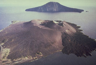 Krakatau