
Smithsonian Institution / US Geological Survey
Weekly Volcanic Activity Report, 3 September-9 September 2026
Managing Editor: Sally Sennert
Please cite this report as:
Global Volcanism Program, 2026. Report on Krakatau (Indonesia) (Sennert, S, ed.). Weekly Volcanic Activity Report, 3 September-9 September 2026. Smithsonian Institution and US Geological Survey. https://volcano.si.edu/showreport.cfm?gvpvar=GVP.WVAR20260903-262000
The Pusat Vulkanologi dan Mitigasi Bencana Geologi (PVMBG) reported ongoing Strombolian activity at Krakatau during 3-9 September, including an intense explosive and effusive phase that caused widespread ashfall and impacts. White, gray, and/or black ash plumes rose as high as 400 m above the summit and drifted W and NW during 3-4 September.
Webcam images at 0419 and at 0428 on 4 September showed incandescent material being ejected above the crater, though webcam images later that day at 2214, at 2242, and at 2253 showed what appeared to be lava fountaining and/or bright an intense ejections of lava. Continuous lava fountaining began at 2307, with sounds of rumbling and roaring along with felt vibrations were reported at the Pasauran Anak Krakatau Volcano Observation Post (50 km ESE) in the Serang Regency. As the eruption intensified there were explosion, rumbling, and booming sounds reported by residents across a large area as far as 200 km E, in Banten (80 km SE), and Lampung (170 km N); a bang was heard and windows and doors vibrated possibly as far as 700 km away according to a news article. The Darwin Volcanic Ash Advisory Centre (VAAC) noted that by 2330 ash plumes had risen to 13.7 km (45,000 ft) a.s.l. and drifted W, and 10 minutes later they had reached 14.6 km (48,000 ft) a.s.l. Webcams showed lava fountains rising 100-400 m above the vent and active lava flows, though ash-and-gas plumes, weather conditions, and darkness sometimes obscured webcam views. By 0050 on 5 September ash plumes had risen to 15.2 km (50,000 ft) a.s.l. and were fanning out to the W. Fountaining was last confirmed at 0100 on 5 September, before webcams were damaged by ejected volcanic material.
By 0150 on 5 September the Darwin VAAC noted that ash was still continuously rising to 15.2 km a.s.l. and drifting W, though ash at 5.5 km (18,000 ft) a.s.l. was drifting S. Within a few hours, by 0450, ash at 15.2 km a.s.l. was drifting W, ash at 6.1 km (20,000 ft) a.s.l. was drifting S, and ash at 5.5 km a.s.l. was drifting ESE. Ash continued to spread in these directions throughout the day. PVMBG reported that lava fountaining, active lava flows, and gas-and-ash emissions were continuous for 25 hours, stopping at 0004 on 6 September. By 1010 on 6 September the higher altitude portion of the ash plume, at 15.2 km, had detached and continued to drifted W, according to the VAAC. After the continuous phase ended, discrete Strombolian explosions were recorded at 0353, 0710, and 2023 on 6 September. Continuously emitted ash plumes were visible in satellite images during 6-7 September rising to 4.6 km (15,000 ft) a.s.l. and spreading E and SE; remnant ash clouds drifted W and E. By 1810 on 7 September the ash plume that had risen to 15.2 km a.s.l. was no longer discernable, though remnant ash at 4.6 km a.s.l. was visible drifting NW. Ash plumes rose to 1.8 km (6,000 ft) a.s.l. and drifted SW.
Ash-and-gas plumes fanned out in multiple directions during 4-8 September, moving SE to S across parts of Banten and west Java, including the capital of Jakarta (160 km E), and SW to NW over parts of Banten (77 km SE), Lampung, Bengkulu (430 km NW), West Sumatra, the southern Sunda Strait, and adjacent Indian Ocean. Nearly 3,000 flights were affected by re-routing, delays, or cancellations at multiple airports across the region; operations were suspended for various periods of time at eight domestic and international airports including Soekarno-Hatta International Airport (138 km E), Halim Perdanakusuma Airport (165 km E, Jakarta), Radin Inten II Airport (95 km NNW, Lampung), Husein Sastranegara Airport (255 km SSE, Bandung, West Java), Budiarto Airport (130 km ESE, Curug, Tangerang), Pondok Cabe Airport (150 km ESE, South Tangerang), Muhammad Taufik Kiemas Airport (190 km NW, Pesisir Barat, Lampung), and Atung Bungsu Airport (320 km NW, Pagar Alam, South Sumatra). The airports reopened on 8 September. Ashfall affected dozens of villages across the Banten and Lampung provinces, in Jakarta, and in other parts of west Java. Authorities advised residents in some areas to stay indoors and wear masks; in Lampung water was sprayed on several roadways to reduce the impact of ashfall.
Five eruptive events were recorded at 0508, 0534, 0749, 1134, and 1756 on 8 September and one was recorded at 1247 on 9 September, but none were visually observed. The Darwin VAAC noted that ash plumes rose 1.5-2.1 km (5,000-7,000 ft) a.s.l. and drifted W and SW during those two days. According to a news report a group of five journalists and three crew members remained missing on 10 September after departing in a speed boat on 7 September to cover the eruption. The Alert Level remained at 3 (on a scale of 1-4) and the public was advised to stay 3 km away from summit.
Sources: Pusat Vulkanologi dan Mitigasi Bencana Geologi (PVMBG, also known as CVGHM), Badan Nacional Penanggulangan Bencana (BNPB), Antara News, Antara News, Antara News, Antara News, Antara News, Antara News, Antara News, Antara News, Antara News, Antara News, Darwin Volcanic Ash Advisory Centre (VAAC)
Geological Summary. The renowned Krakatau (frequently misnamed as Krakatoa) volcano lies in the Sunda Strait between Java and Sumatra. Collapse of an older edifice, perhaps in 416 or 535 CE, formed a 7-km-wide caldera. Remnants of that volcano are preserved in Verlaten and Lang Islands; subsequently the Rakata, Danan, and Perbuwatan cones were formed, coalescing to create the pre-1883 Krakatau Island. Caldera collapse during the catastrophic 1883 eruption destroyed Danan and Perbuwatan, and left only a remnant of Rakata. This eruption caused more than 36,000 fatalities, most as a result of tsunamis that swept the adjacent coastlines of Sumatra and Java. Pyroclastic surges traveled 40 km across the Sunda Strait and reached the Sumatra coast. After a quiescence of less than a half century, the post-collapse cone of Anak Krakatau (Child of Krakatau) was constructed within the 1883 caldera at a point between the former Danan and Perbuwatan cones. Anak Krakatau has been the site of frequent eruptions since 1927.


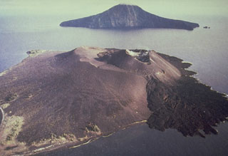 Krakatau