Report on Papandayan (Indonesia) — 9 January-15 January 2008
Smithsonian Institution / US Geological Survey
Weekly Volcanic Activity Report, 9 January-15 January 2008
Managing Editor: Sally Sennert.
Please cite this report as:
Global Volcanism Program, 2008. Report on Papandayan (Indonesia) (Sennert, S, ed.). Weekly Volcanic Activity Report, 9 January-15 January 2008. Smithsonian Institution and US Geological Survey.
Papandayan
Indonesia
7.3175°S, 107.7306°E; summit elev. 2643 m
All times are local (unless otherwise noted)
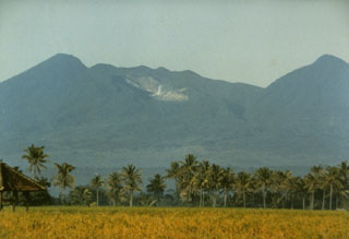
On 7 January, CVGHM lowered the Alert Level at Papandayan from 2 to 1 (on a scale of 1-4) due to a decrease in activity over approximately four months. Seismic events decreased in number after 2 August 2007, and earthquake tremor was not recorded since 14 November 2007. Data from deformation-monitoring instruments indicated deflation. White fumarolic plumes rose to an altitude of 2.9 km (9,500 ft) a.s.l.
Geological Summary. Papandayan is a complex stratovolcano at the S end of a curved volcanic massif with Kendang volcano ~9 km away at the N end, Gunung Puntang ~3.5 km NNE, and Gunung Jaya ~6 km NNE. Several episodes of collapse have created an irregular profile and produced debris avalanches that have affected lowland areas. The summit area includes four large craters, including the 1.1-km-wide, flat-floored Alun-Alun crater. A sulfur-encrusted fumarole field occupies the active Kawah Mas ("Golden Crater"). The first reported eruption, in 1772 CE, included a collapse of the NE flank and a debris avalanche that destroyed 40 villages and killed almost 3,000 people. Smaller phreatic eruptions occurred during 1923-25, 1942, and 2002.
Source: Pusat Vulkanologi dan Mitigasi Bencana Geologi (PVMBG, also known as CVGHM)