Report on Kasatochi (United States) — 20 August-26 August 2008
Smithsonian Institution / US Geological Survey
Weekly Volcanic Activity Report, 20 August-26 August 2008
Managing Editor: Sally Sennert.
Please cite this report as:
Global Volcanism Program, 2008. Report on Kasatochi (United States) (Sennert, S, ed.). Weekly Volcanic Activity Report, 20 August-26 August 2008. Smithsonian Institution and US Geological Survey.
Kasatochi
United States
52.177°N, 175.508°W; summit elev. 314 m
All times are local (unless otherwise noted)
AVO reported that during 20-26 August seismic activity from Kasatochi was detected by stations on Great Sitkin, approximately 40 km W. Clouds prevented satellite image observations. Active fumaroles and hot pyroclastic flow deposits over much of the volcano were observed on 22 August by a visiting scientist. On 23 August, the smell of sulfur was reported in the town of Adak. The Volcano Alert Level remained at Watch and the Aviation Color Code at Orange.
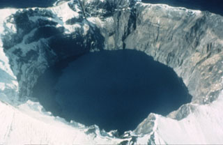
Geological Summary. Located at the northern end of a shallow submarine ridge trending perpendicular to the Aleutian arc, Kasatochi is small 2.7 x 3.3 km island volcano with a 750-m-wide summit crater lake. The summit reaches only about 300 m elevation, and the lake surface lies less than about 60 m above the sea. A lava dome is located on the NW flank at about 150 m elevation. The asymmetrical island is steeper on the northern side than the southern, and the crater lies north of the center of the island. Reports of activity from the heavily eroded Koniuji volcano to the east probably refer to eruptions from Kasatochi. A lava flow may have been emplaced during the first recorded eruption in 1760. A major explosive eruption in 2008 produced pyroclastic flows and surges that swept into the sea, extending the island's shoreline.
Source: US Geological Survey Alaska Volcano Observatory (AVO)