Report on Chaiten (Chile) — 29 October-4 November 2008
Smithsonian Institution / US Geological Survey
Weekly Volcanic Activity Report, 29 October-4 November 2008
Managing Editor: Sally Sennert.
Please cite this report as:
Global Volcanism Program, 2008. Report on Chaiten (Chile) (Sennert, S, ed.). Weekly Volcanic Activity Report, 29 October-4 November 2008. Smithsonian Institution and US Geological Survey.
Chaiten
Chile
42.8349°S, 72.6514°W; summit elev. 1122 m
All times are local (unless otherwise noted)
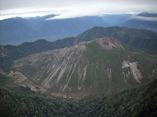
On 29 October, SERNAGEOMIN received reports of an increase in activity at Chaitén characterized by several explosions that darkened the plume and caused it to rise from about 1.6 km (5,200 ft) a.s.l to about 3.1 km (10,200 ft) a.s.l. SERNAGEOMIN reported that variations in seismicity remained similar to patterns detected during the pervious weeks. A gas plume was continually emitted to an altitude of 3.1 km (10,200 ft) a.s.l. during the previous week. ONEMI reported that during an overflight on 30 October, scientists observed a landslide that had originated from the active lava dome. The next day observers described a plume emitted from multiple areas that rose to an altitude of 2.1 km (6,900 ft) a.s.l. The white component of the plume (steam and gas) emitted mainly from the center and S parts of the lava dome. Vents on the N and NE area produced a gray plume. The Alert Level remained Red.
Based on observations of satellite imagery, Puerto Montt Flight Information Region (FIR) notices, web camera views, SIGMET notices, and pilot reports, the Buenos Aires VAAC reported that during 29-30 October and 1-3 November ash plumes from Chaitén rose to altitudes 2.4-3.7 km (8,000-12,000 ft) a.s.l. and drifted N, NE, and E. Thermal anomalies were present on 30 October and 2 November.
On 4 November, SERNAGEOMIN reported that a recent overflight confirmed the presence of a second new lava dome. The new dome grew in the NE part of the first dome that started to form in May 2008, and had a diameter of about 300 m and a height of about 150 m. Spines protruded from the top. Seismicity was concentrated underneath that area.
Geological Summary. Chaitén is a small caldera (~3 km in diameter) located 10 km NE of the town of Chaitén on the Gulf of Corcovado. Multiple explosive eruptions throughout the Holocene have been identified. A rhyolitic obsidian lava dome occupies much of the caldera floor. Obsidian cobbles from this dome found in the Blanco River are the source of artifacts from archaeological sites along the Pacific coast as far as 400 km from the volcano to the N and S. The caldera is breached on the SW side by a river that drains to the bay of Chaitén. The first recorded eruption, beginning in 2008, produced major rhyolitic explosive activity and building a new dome and tephra cone on the older rhyolite dome.
Sources: Servicio Nacional de Geología y Minería (SERNAGEOMIN), Oficina Nacional de Emergencia-Ministerio del Interior (ONEMI), Buenos Aires Volcanic Ash Advisory Center (VAAC)

