
Smithsonian Institution / US Geological Survey
Weekly Volcanic Activity Report, 17 March-23 March 2010
Managing Editor: Sally Sennert
Please cite this report as:
Global Volcanism Program, 2010. Report on Chaiten (Chile) (Sennert, S, ed.). Weekly Volcanic Activity Report, 17 March-23 March 2010. Smithsonian Institution and US Geological Survey. https://volcano.si.edu/showreport.cfm?gvpvar=GVP.WVAR20100317-358041
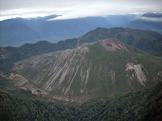
On 17 March SERNAGEOMIN reported that, during the previous few weeks, growth of Chaitén's lava-dome complex was concentrated in the W part. Gas-and-ash plumes, seen through the video camera located on the rim of the caldera, rose at most 1 km from the central area of the domes. Seismic activity persisted at a low level. The Alert Level remained at Red.
Source: Servicio Nacional de Geología y Minería (SERNAGEOMIN)
Geological Summary. Chaitén is a small caldera (~3 km in diameter) located 10 km NE of the town of Chaitén on the Gulf of Corcovado. Multiple explosive eruptions throughout the Holocene have been identified. A rhyolitic obsidian lava dome occupies much of the caldera floor. Obsidian cobbles from this dome found in the Blanco River are the source of artifacts from archaeological sites along the Pacific coast as far as 400 km from the volcano to the N and S. The caldera is breached on the SW side by a river that drains to the bay of Chaitén. The first recorded eruption, beginning in 2008, produced major rhyolitic explosive activity and building a new dome and tephra cone on the older rhyolite dome.


 Chaiten