Report on Eyjafjallajokull (Iceland) — 14 April-20 April 2010
Smithsonian Institution / US Geological Survey
Weekly Volcanic Activity Report, 14 April-20 April 2010
Managing Editor: Sally Sennert.
Please cite this report as:
Global Volcanism Program, 2010. Report on Eyjafjallajokull (Iceland) (Sennert, S, ed.). Weekly Volcanic Activity Report, 14 April-20 April 2010. Smithsonian Institution and US Geological Survey.
Eyjafjallajokull
Iceland
63.633°N, 19.633°W; summit elev. 1651 m
All times are local (unless otherwise noted)
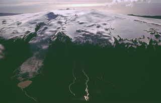
The Institute of Earth Sciences at the Nordic Volcanological Center (NVC) reported that a new set of craters opened in the early morning of 14 April under the ice-covered central summit caldera of Eyjafjallajökull. This eruptive phase was preceded by a swarm of earthquakes and the onset of tremor. Aerial observations revealed a series of vents along a 2-km-long N-S fissure, with meltwater flowing down both the N and S slopes of the volcano. An ash plume rose to more than 8 km altitude, and was deflected to the E by winds. Jokulhlaups (floods of meltwater) reached the lowlands around the volcano with peak flow around noon, damaging roads, infrastructure, and farmlands. There were no fatalities due to previous evacuations. Tephra-fall was reported in SE Iceland. A second jokulhlaup/lahar traveled down the Markarfljot valley that evening.
On 15 April the eruption plume reached mainland Europe, causing the closure of large areas of airspace. Activity continued during 16 April at a similar level as the previous day, with ash generation and pulses of meltwater causing jokulhlaup/lahars in the evening. The next day there was some variability in seismic tremor and tephra generation, but overall the activity remained stable. A pulsating eruptive column reached above 8 km altitude, and lightning was frequently seen within the plume.
Over the first 72 hours of explosive activity, scientists estimated that the eruption had produced 140 million cubic meters of tephra. An update from NVC on 21 April noted that activity had declined in the previous few days by an order of magnitude, though phreatomagmatic explosions were still occurring, sending plumes about 3 km high. Lava spattering was seen at the craters, and meltwater flows were minor. Seismicity was not decreasing at that time, and samples collected on 19 April were of the same intermediate composition (58% SiO2) as early in the explosive phase, but with more fluorine.
The ash cloud resulted in the cancellation of tens of thousands of daily flights, both into and out of major European cities, after 15 April. Although on 19 April the plume was only rising 1 km above the summit, it was ascending to altitudes of 5-7 km (15-20,000 ft) as it drifted to the S. Beginning on 20 April, after a decrease in activity and a significant dissipation of the plume, many previously closed areas were at least partially opened for limited service.
Geological Summary. Eyjafjallajökull (also known as Eyjafjöll) is located west of Katla volcano. It consists of an elongated ice-covered stratovolcano with a 2.5-km-wide summit caldera. Fissure-fed lava flows occur on both the E and W flanks, but are more prominent on the western side. Although the volcano has erupted during historical time, it has been less active than other volcanoes of Iceland's eastern volcanic zone, and relatively few Holocene lava flows are known. An intrusion beneath the S flank from July-December 1999 was accompanied by increased seismic activity. The last historical activity prior to an eruption in 2010 produced intermediate-to-silicic tephra from the central caldera during December 1821 to January 1823.
Sources: Icelandic Meteorological Office (IMO), Iceland Review, Institute of Earth Sciences