Report on Tengger Caldera (Indonesia) — 4 May-10 May 2011
Smithsonian Institution / US Geological Survey
Weekly Volcanic Activity Report, 4 May-10 May 2011
Managing Editor: Sally Sennert.
Please cite this report as:
Global Volcanism Program, 2011. Report on Tengger Caldera (Indonesia) (Sennert, S, ed.). Weekly Volcanic Activity Report, 4 May-10 May 2011. Smithsonian Institution and US Geological Survey.
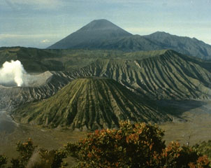
Tengger Caldera
Indonesia
7.942°S, 112.95°E; summit elev. 2329 m
All times are local (unless otherwise noted)
Based on analyses of satellite imagery, the Darwin VAAC reported that during 9-10 May ash plumes from Tengger Caldera's Bromo cone rose to an altitude of 2.7 km (9,000 ft) a.s.l. and drifted 45-75 km NE and E.
Geological Summary. The 16-km-wide Tengger caldera is located at the northern end of a volcanic massif extending from Semeru volcano. The massive volcanic complex dates back to about 820,000 years ago and consists of five overlapping stratovolcanoes, each truncated by a caldera. Lava domes, pyroclastic cones, and a maar occupy the flanks of the massif. The Ngadisari caldera at the NE end of the complex formed about 150,000 years ago and is now drained through the Sapikerep valley. The most recent of the calderas is the 9 x 10 km wide Sandsea caldera at the SW end of the complex, which formed incrementally during the late Pleistocene and early Holocene. An overlapping cluster of post-caldera cones was constructed on the floor of the Sandsea caldera within the past several thousand years. The youngest of these is Bromo, one of Java's most active and most frequently visited volcanoes.