Report on Hierro (Spain) — 5 October-11 October 2011
Smithsonian Institution / US Geological Survey
Weekly Volcanic Activity Report, 5 October-11 October 2011
Managing Editor: Sally Sennert.
Please cite this report as:
Global Volcanism Program, 2011. Report on Hierro (Spain) (Sennert, S, ed.). Weekly Volcanic Activity Report, 5 October-11 October 2011. Smithsonian Institution and US Geological Survey.
Hierro
Spain
27.73°N, 18.03°W; summit elev. 1500 m
All times are local (unless otherwise noted)
Instituto Geográfico Nacional (IGN) reported more than 700 new seismic events were detected at Hierro during 4-11 October, 52 of them were felt by residents. A M 4.3 earthquake was detected on 8 October, located 1.5 km from the SW coast of the island at 14 km depth. Following the event, the trend of the superficial deformation changed, suggesting deflation of the system. During the night of 8 October through the following day, low-magnitude seismic events occurred at depths of less than 2 km. Since 0515 on 10 October volcanic tremor was clearly recorded by all of the seismic stations on the island, with highest amplitudes recorded in the southernmost station. All data suggested a submarine eruption.
On 11 October at about 0700 the amplitude of the tremor increased. During that morning residents on the S of the island reported feeling vibrations. After midday, the Government of the Canary Islands raised the Alert Code to Red for Restinga village (at the southernmost point of Hierro) and evacuated the residents. A maritime exclusion zone extended about 4 nautical miles from Restinga.
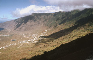
Geological Summary. The triangular island of Hierro is the SW-most and least studied of the Canary Islands. The massive shield volcano is truncated by a large NW-facing escarpment formed as a result of gravitational collapse of El Golfo volcano about 130,000 years ago. The steep-sided scarp towers above a low lava platform bordering 12-km-wide El Golfo Bay, and three other large submarine landslide deposits occur to the SW and SE. Three prominent rifts oriented NW, NE, and S form prominent topographic ridges. The subaerial portion of the volcano consists of flat-lying Quaternary basaltic and trachybasaltic lava flows and tuffs capped by numerous young cinder cones and lava flows. Holocene cones and flows are found both on the outer flanks and in the El Golfo depression. Hierro contains the greatest concentration of young vents in the Canary Islands. Uncertainty surrounds the report of an eruption in 1793. A submarine eruption took place about 2 km SSW off the southern point of the island during 2011-12.