Report on Lokon-Empung (Indonesia) — 21 December-27 December 2011
Smithsonian Institution / US Geological Survey
Weekly Volcanic Activity Report, 21 December-27 December 2011
Managing Editor: Sally Sennert.
Please cite this report as:
Global Volcanism Program, 2011. Report on Lokon-Empung (Indonesia) (Sennert, S, ed.). Weekly Volcanic Activity Report, 21 December-27 December 2011. Smithsonian Institution and US Geological Survey.
Lokon-Empung
Indonesia
1.3644°N, 124.7992°E; summit elev. 1580 m
All times are local (unless otherwise noted)
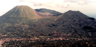
According to a news article, three explosions from the Tompaluan crater, in the saddle between the Lokon-Empung peaks were recorded by the CVGHM on 27 December. CVGHM recorded 23 deep volcanic tremors and 40 shallow volcanic tremors. Residents and tourists were not permitted within a 2.5 km radius of the crater. Based on visual and seismic observations during 27-28 December, the Alert Level remained at 3 (on a scale of 1-4). The Darwin VAAC reported a low-level eruption on 27 December based on media reports.
Geological Summary. The Lokong-Empung volcanic complex, rising above the plain of Tondano in North Sulawesi, includes four peaks and an active crater. Lokon, the highest peak, has a flat craterless top. The morphologically younger Empung cone 2 km NE has a 400-m-wide, 150-m-deep crater that erupted last in the 18th century. A ridge extending 3 km WNW from Lokon includes the Tatawiran and Tetempangan peaks. All eruptions since 1829 have originated from Tompaluan, a 150 x 250 m crater in the saddle between Lokon and Empung. These eruptions have primarily produced small-to-moderate ash plumes that sometimes damaged croplands and houses, but lava-dome growth and pyroclastic flows have also occurred.
Sources: The Jakarta Post, Pusat Vulkanologi dan Mitigasi Bencana Geologi (PVMBG, also known as CVGHM), Darwin Volcanic Ash Advisory Centre (VAAC)