Report on Chirpoi (Russia) — 24 July-30 July 2013
Smithsonian Institution / US Geological Survey
Weekly Volcanic Activity Report, 24 July-30 July 2013
Managing Editor: Sally Sennert.
Please cite this report as:
Global Volcanism Program, 2013. Report on Chirpoi (Russia) (Sennert, S, ed.). Weekly Volcanic Activity Report, 24 July-30 July 2013. Smithsonian Institution and US Geological Survey.
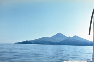
Chirpoi
Russia
46.532°N, 150.871°E; summit elev. 742 m
All times are local (unless otherwise noted)
SVERT reported that possible steam-and-gas emissions from Snow, a volcano of Chirpoi, were detected in satellite images on 23 July. The Aviation Color Code remained at Yellow.
Geological Summary. Chirpoi, a small island lying between the larger islands of Simushir and Urup, contains a half dozen volcanic edifices constructed within an 8-9 km wide, partially submerged caldera. The southern rim of the caldera is exposed on nearby Brat Chirpoev Island. The symmetrical Cherny volcano, which forms the central cone of the island, erupted twice during the 18th and 19th centuries. The youngest volcano, Snow, originated between 1770 and 1810. It is composed almost entirely of lava flows, many of which have reached the sea on the southern coast. No recorded eruptions are known from Brat Chirpoev, but its youthful morphology suggests recent Strombolian activity.