Report on Ijen (Indonesia) — 21 August-27 August 2013
Smithsonian Institution / US Geological Survey
Weekly Volcanic Activity Report, 21 August-27 August 2013
Managing Editor: Sally Sennert.
Please cite this report as:
Global Volcanism Program, 2013. Report on Ijen (Indonesia) (Sennert, S, ed.). Weekly Volcanic Activity Report, 21 August-27 August 2013. Smithsonian Institution and US Geological Survey.
Ijen
Indonesia
8.058°S, 114.242°E; summit elev. 2769 m
All times are local (unless otherwise noted)
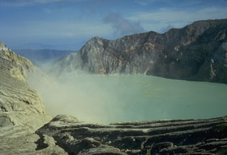
CVGHM reported that during 1 July-25 August diffuse white plumes rose 100-150 m above Ijen's crater, the lake water was light green, and seismicity decreased. On 26 August the Alert Level was lowered to 2 (on a scale of 1-4). Visitors, tourists, miners, and hikers were reminded not to approach the crater within 1 km.
Geological Summary. The Ijen volcano complex at the eastern end of Java consists of a group of small stratovolcanoes constructed within the 20-km-wide Ijen (Kendeng) caldera. The north caldera wall forms a prominent arcuate ridge, but elsewhere the rim was buried by post-caldera volcanoes, including Gunung Merapi, which forms the high point of the complex. Immediately west of the Gunung Merapi stratovolcano is the historically active Kawah Ijen crater, which contains a nearly 1-km-wide, turquoise-colored, acid lake. Kawah Ijen is the site of a labor-intensive mining operation in which baskets of sulfur are hand-carried from the crater floor. Many other post-caldera cones and craters are located within the caldera or along its rim. The largest concentration of cones forms an E-W zone across the southern side of the caldera. Coffee plantations cover much of the caldera floor; nearby waterfalls and hot springs are tourist destinations.
Source: Pusat Vulkanologi dan Mitigasi Bencana Geologi (PVMBG, also known as CVGHM)

