Report on Lokon-Empung (Indonesia) — 4 September-10 September 2013
Smithsonian Institution / US Geological Survey
Weekly Volcanic Activity Report, 4 September-10 September 2013
Managing Editor: Sally Sennert.
Please cite this report as:
Global Volcanism Program, 2013. Report on Lokon-Empung (Indonesia) (Sennert, S, ed.). Weekly Volcanic Activity Report, 4 September-10 September 2013. Smithsonian Institution and US Geological Survey.
Lokon-Empung
Indonesia
1.3644°N, 124.7992°E; summit elev. 1580 m
All times are local (unless otherwise noted)
Based on ground reports from CVGHM, the Darwin VAAC reported that on 9 September an ash plume from Lokon-Empung rose to an altitude of 1.8 km (6,000 ft) a.s.l. and drifted N. Ash was not detected in satellite images due to meteorological clouds. According to a news article an explosion at 0630 generated an ash plume that rose 1.5 km; the explosion was heard 10 km away. The VAAC noted that the next day ash plumes rose to an altitude of 2.4 km (8,000 ft) a.s.l. although ash was again not identified in satellite images.
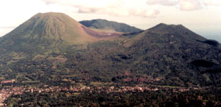
Geological Summary. The Lokong-Empung volcanic complex, rising above the plain of Tondano in North Sulawesi, includes four peaks and an active crater. Lokon, the highest peak, has a flat craterless top. The morphologically younger Empung cone 2 km NE has a 400-m-wide, 150-m-deep crater that erupted last in the 18th century. A ridge extending 3 km WNW from Lokon includes the Tatawiran and Tetempangan peaks. All eruptions since 1829 have originated from Tompaluan, a 150 x 250 m crater in the saddle between Lokon and Empung. These eruptions have primarily produced small-to-moderate ash plumes that sometimes damaged croplands and houses, but lava-dome growth and pyroclastic flows have also occurred.
Sources: Darwin Volcanic Ash Advisory Centre (VAAC), Jakarta Globe