Report on Zhupanovsky (Russia) — 25 June-1 July 2014
Smithsonian Institution / US Geological Survey
Weekly Volcanic Activity Report, 25 June-1 July 2014
Managing Editor: Sally Sennert.
Please cite this report as:
Global Volcanism Program, 2014. Report on Zhupanovsky (Russia) (Sennert, S, ed.). Weekly Volcanic Activity Report, 25 June-1 July 2014. Smithsonian Institution and US Geological Survey.
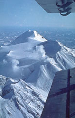
Zhupanovsky
Russia
53.589°N, 159.15°E; summit elev. 2899 m
All times are local (unless otherwise noted)
KVERT reported that during 20-26 June, moderate gas-and-steam activity was observed at Zhupanovsky. Satellite data showed ash plumes drifting 55 km NW from the volcano. During June 27-28 cloud cover prevented views from satellite. The Aviation Color Code is Orange.
Geological Summary. The Zhupanovsky volcanic massif consists of four overlapping stratovolcanoes along a WNW-trending ridge. The elongated complex was constructed within a Pliocene-early Pleistocene caldera whose rim is exposed only on the eastern side. Three of the stratovolcanoes were built during the Pleistocene. An early Holocene stage of frequent moderate and weak eruptions from 7,000 to 5,000 years before present (BP) was followed by a period of infrequent larger eruptions that produced pyroclastic flows. The last major eruption took place about 800-900 BP. Recorded eruptions have consisted of relatively minor explosions from Priemysh, the third cone from the E about 2.5 km from the summit peak.