Report on Hakoneyama (Japan) — 8 July-14 July 2015
Smithsonian Institution / US Geological Survey
Weekly Volcanic Activity Report, 8 July-14 July 2015
Managing Editor: Sally Sennert.
Please cite this report as:
Global Volcanism Program, 2015. Report on Hakoneyama (Japan) (Sennert, S, ed.). Weekly Volcanic Activity Report, 8 July-14 July 2015. Smithsonian Institution and US Geological Survey.
Hakoneyama
Japan
35.233°N, 139.021°E; summit elev. 1438 m
All times are local (unless otherwise noted)
On 12 July JMA reported that the webcam continued to record vigorous fumarolic plumes rising from Hakoneyama's Owakudani hot spring area. The Alert Level remained at 3 (on a 5-level scale).
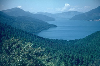
Geological Summary. Hakoneyama volcano is truncated by two overlapping calderas, the largest of which is 10 x 11 km wide. The calderas were formed as a result of two major explosive eruptions about 180,000 and 49,000-60,000 years ago. Scenic Lake Ashi lies between the SW caldera wall and a half dozen post-caldera lava domes that were constructed along a NW-SE trend cutting through the center of the calderas. Dome growth occurred progressively to the NW, and the largest and youngest of these, Kamiyama, forms the high point. The calderas are breached to the east by the Hayakawa canyon. A phreatic explosion about 3000 years ago was followed by collapse of the NW side of Kamiyama, damming the Hayakawa valley and creating Lake Ashi. The latest magmatic eruptive activity about 2900 years ago produced a pyroclastic flow and a lava dome in the explosion crater, although phreatic eruptions took place as recently as the 12-13th centuries CE. Seismic swarms have occurred during the 20th century. Lake Ashi, along with the thermal areas in the caldera, is a popular resort destination SW of Tokyo.