Report on Colo (Indonesia) — 28 October-3 November 2015
Smithsonian Institution / US Geological Survey
Weekly Volcanic Activity Report, 28 October-3 November 2015
Managing Editor: Sally Sennert.
Please cite this report as:
Global Volcanism Program, 2015. Report on Colo (Indonesia) (Sennert, S, ed.). Weekly Volcanic Activity Report, 28 October-3 November 2015. Smithsonian Institution and US Geological Survey.
Colo
Indonesia
0.162°S, 121.601°E; summit elev. 404 m
All times are local (unless otherwise noted)
PVMBG reported that seismicity at Colo declined during 1 September-25 October; 1-7 shallow-volcanic earthquakes and 1-3 volcanic earthquakes were recorded per day, which were rates similar to those recorded before a seismic increase in June. The Alert Level was lowered to 1 (on a scale of 1-4) on 26 October, and residents and tourists were warned not to approach the crater.
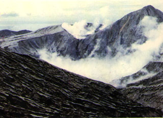
Geological Summary. Colo volcano forms the isolated small island of Una Una in the middle of the Gulf of Tomini in northern Sulawesi. The broad, low volcano contains a 2-km-wide caldera with a small central cone. Three eruptions have been recorded since the late 1800's, but two of those caused widespread damage over the island. The last eruption, in 1983, produced pyroclastic flows that swept over most of the island shortly after all residents had been evacuated.
Source: Pusat Vulkanologi dan Mitigasi Bencana Geologi (PVMBG, also known as CVGHM)