Report on Askja (Iceland) — 2 November-8 November 2022
Smithsonian Institution / US Geological Survey
Weekly Volcanic Activity Report, 2 November-8 November 2022
Managing Editor: Sally Sennert.
Please cite this report as:
Global Volcanism Program, 2022. Report on Askja (Iceland) (Sennert, S, ed.). Weekly Volcanic Activity Report, 2 November-8 November 2022. Smithsonian Institution and US Geological Survey.
Askja
Iceland
65.033°N, 16.783°W; summit elev. 1080 m
All times are local (unless otherwise noted)
On 9 November Icelandic Meteorological Office (IMO) lowered the Aviation Color Code for Askja to Green (the lowest level on a four-color scale) noting that although deformation data indicted continuing magma accumulation at depth, with a total uplift of 40 cm since August 2021, it was not accompanied by elevated seismicity.
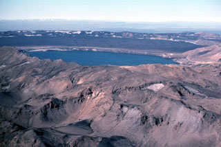
Geological Summary. Askja is a large basaltic central volcano that forms the Dyngjufjöll massif. It is truncated by three overlapping calderas, the largest of which is 8 km wide and may have been produced primarily from subglacial ring-fracture eruptions rather than by subsidence. A major rhyolitic explosive eruption from Dyngjufjöll about 10,000 years ago was in part associated with the formation of Askja caldera. Many postglacial eruptions also occurred along the ring-fracture. A major explosive eruption on the SE caldera margin in 1875 was one of Iceland's largest during historical time. It resulted in the formation of a smaller 4.5-km-wide caldera, now filled by Öskjuvatn lake, that truncates the rim of the larger central caldera. The 100-km-long Askja fissure swarm, which includes the Sveinagja graben, is also related to the Askja volcanic system, as are several small shield volcanoes such as Kollatadyngja. Twentieth-century eruptions have produced lava flows from vents located mostly near Öskjuvatn lake.

