
Smithsonian Institution / US Geological Survey
Weekly Volcanic Activity Report, 18 September-24 September 2024
Managing Editor: Sally Sennert
Please cite this report as:
Global Volcanism Program, 2024. Report on Sumisujima (Japan) (Sennert, S, ed.). Weekly Volcanic Activity Report, 18 September-24 September 2024. Smithsonian Institution and US Geological Survey. https://volcano.si.edu/showreport.cfm?gvpvar=GVP.WVAR20240918-284080
According to the Japan Meteorological Agency (JMA) discolored water around Sumisujima was observed on 18 September during an overflight conducted by the Japan Coast Guard. An area of pale-blue to white discolored water extended about 1.8 km NW of the N coast of the island. A very small amount of grayish-white material was floating in the same area as the discolored water and along the W coast. At 1100 on 19 September JMA issued an “eruption warning” noting that an eruption could affect the surround waters of the island.
Source: Japan Meteorological Agency (JMA)
Geological Summary. Sumisujima (also known as Smith Rocks) is a steep-sided basaltic pinnacle that forms part of the outer southern flank of a 8-9 km submarine caldera that truncates a 20-km-wide seamount. The caldera was formed between about 60,000 and 30,000 years ago. The Shirane dacitic central cone, 3 km wide and 800 m high, rises to within 8 m of the ocean surface in the eastern side of the caldera, whose 600-700 m walls and outer flanks expose basaltic, andesitic, and rhyolitic rocks. Two large submarine cones, Sumisu Knolls No. 1 and 2, lie west of the caldera. Submarine eruptions have been reported from a number of locations near Sumisujima, the last of which occurred in 1916. Water discoloration has frequently been observed since the 1970's. In October 1992 a 6-km-long zone of discolored water was seen extending from the shallow Shirane rock mass near the eastern rim of the caldera, which rises to within 7 m of the ocean surface and is the youngest feature of the volcanic complex.


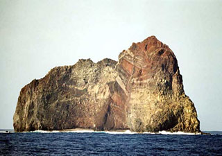 Sumisujima