Report on Purace (Colombia) — 19 November-25 November 2025
Smithsonian Institution / US Geological Survey
Weekly Volcanic Activity Report, 19 November-25 November 2025
Managing Editor: Sally Sennert.
Please cite this report as:
Global Volcanism Program, 2025. Report on Purace (Colombia) (Sennert, S, ed.). Weekly Volcanic Activity Report, 19 November-25 November 2025. Smithsonian Institution and US Geological Survey.
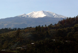
Purace
Colombia
2.3095°N, 76.3948°W; summit elev. 4650 m
All times are local (unless otherwise noted)
At 0740 on 25 November the Servicio Geologico Colombiano (SGC) reported that increased seismicity at Puracé had been detected for a few hours. The seismicity was characterized by tremor and long-period signals located beneath the crater at depths less than 1 km. The signals were accompanied by gas plumes that rose up to 1.6 km above the summit and drifted SW. A small amount of ash may have been present in the plumes. The Alert Level remained at Yellow (the second lowest level on a four-color scale).
Geological Summary. Puracé is an active andesitic volcano with a 600-m-diameter summit crater at the NW end of the Los Coconucos Volcanic Chain. This volcanic complex includes nine composite and five monogenetic volcanoes, extending from the Puracé crater more than 6 km SE to the summit of Pan de Azúcar stratovolcano. The dacitic massif which the complex is built on extends about 13 km NW-SE and 10 km NE-SW. Frequent small to moderate explosive eruptions reported since 1816 CE have modified the morphology of the summit crater, with the largest eruptions in 1849, 1869, and 1885.