
Hydrothermally active submarine volcano found in 2008
The Australian Commonwealth Scientific and Industrial Research Organization (CSIRO) announced in press releases that several large active submarine volcanoes, spreading ridges, and rift zones had been discovered in the Northwest Lau back-arc basin, NE of Fiji Island (figure 1). The discoveries were made by a team of Australian and American scientists aboard the CSIRO Marine National Facility Research Vessel Southern Surveyor in Spring 2008 (CSIRO, 2008a). While mapping previously uncharted areas for submarine volcanic and hot spring activity, the team located several volcanoes, one of which they named Lobster. The depth of Lobster is given as 1,500 m in the InterRidge Vents Database [Ver. 3.1] (2013). The location of Lobster is shown in figure 1, based on coordinates given in Lupton and others (2012). The base maps in figure 1 came from Keller and others (2008), a study primarily discussing the area in the rectangle on the larger map. The sea floor was mapped with multibeam sonar. Lobster is located ~75 km NNW of Niuafo'ou volcano/island and ~680 km NE of Suva, Fiji (figure 1). Dugong volcano lies ~60 km E of Lobster.
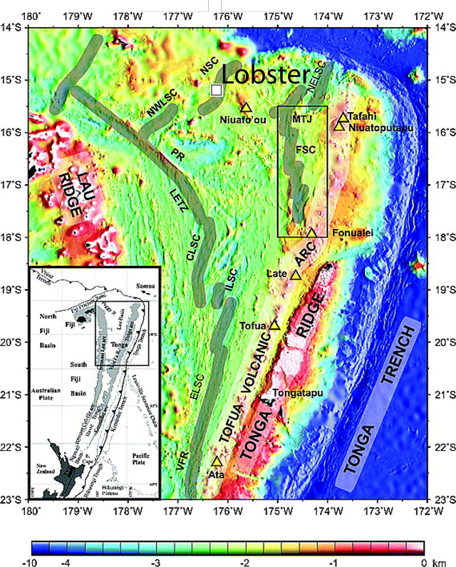 |
Figure 1. Two maps showing (lower left) North Island, New Zealand (in black) and selected plate tectonic features along the Kermadec and Tonga trenches (hachured line with teeth on upthrown side) and (larger map) Lobster (white square) and other features such as the main spreading centers, geographical features, and subaerial volcanoes (open yellow triangles). Note Niuafo'ou volcano and island, and the location of Lobster (and Dugong, a neighboring volcano discussed in a separate Bulletin report and plotted on a larger map). Abbreviations are as follows: VFR - Valu fa ridge; ELSC - East Lau spreading center; ILSC - Intermediate Lau spreading center; CLSC - Central Lau spreading center; LETZ - Lau Extentional transform zone; PR - Peggy Ridge; NWLSC - Northwest Lau spreading center; NSC - Niuafo'ou spreading center (location of Rochambeau Rifts); NELSC - Northeast Lau spreading center; FSC - Fonualei spreading center; and MTJ - Mangatolu triple junction. Courtesy of Keller and others (2008). |
Lobster volcano's caldera is 2x2.5 km in diameter with a floor at 1.5 km depth (figure 2). It was described as residing amid four radiating rift zones.
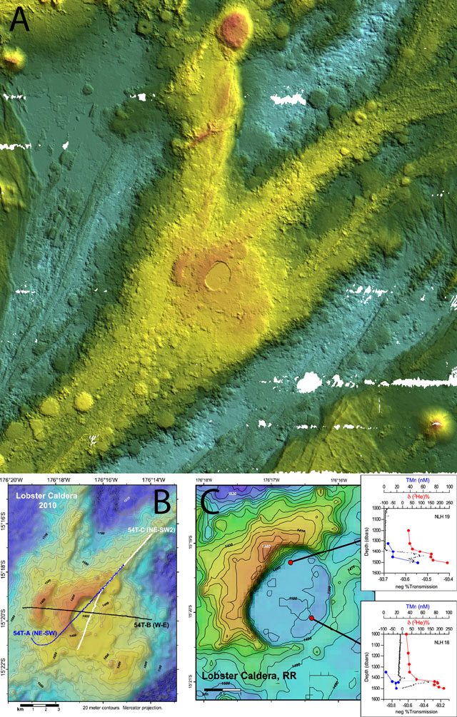 |
Figure 2. (a) Multibeam sonar three-dimensional (30 kHz swathmap) image made in 2008 of Lobster which sits in what was described as the center of a rift zone and astride a spreading ridge to its W (CSIRO, 2008). Image lacks scale for depth values, but in relative terms light blue is the deepest, trending upwards through dark-to-light green, yellow, orange, and then red as the shallowest. Image from news release of CSIRO (2008b). (b) Shaded relief, contour map of Lobster caldera on the Rochambeau rifts showing part of a survey track completed in 2010 by the research vessel Dorado Discovery. Taken from Lupton and others (2012). (c) Detail map of Lobster Caldera showing locations and profiles for two chemistry hydrocasts. Inserts show vertical profiles of δ3He (deviation of the 3He/4He ratio measured at depth from the atmospheric ratio), total Mn (manganese), and %T transmission of light (a measure of suspended particles) plotted versus depth. Taken from Lupton and others (2012). |
The caldera's rim is about 100 m high on the W side whereas only ~20 m high on the E side.
Dredge samples from Lobster recovered in 2008 contained olivine and plagioclase in pillow basalts. A dredge sample taken on the smooth caldera floor recovered fresh flows as well as thick, black aphyric pillows with glassy rinds.
Age. According to Arculus (2008) and Lupton and others (2012), active venting was identified in the form of high helium anomalies (δ3He), suspended particles (%T), and trace metals (manganese and iron) at 60 m off the bottom in the SE corner of the summit caldera. Lupton and others (2012) reported, in 2012, that the site was still active.
The expedition mapped the seafloor using a 30 kHz multibeam sonar with Global Positioning System (GPS) and an Inertial Motion Unit (IMU) to track the ship's position and attitude. They also made vertical conductivity, temperature, and depth (CTD) measurements as well as rock dredging. In addition, by lowering the CTD package up and down a few hundred meters from the bottom, while moving the ship, they obtained a far greater density of data. This technique, often informally referred to as a CTD tow-yo, is effective for mapping and sampling hydrothermal plumes.
References. Arculus, R.J., 2008, Marine National Facility RV Southern Survey 2008 Program: Voyage Summary SS07/2008 Northern Lau Vents Expedition (NoLauVE), 23 p (URL: http://www.cmar.csiro.au/datacentre/process/data_files/cruise_docs/SS200807sum.pdf).
CSIRO, 2008a, Active submarine volcanoes found near Fiji, CSIRO web site (URL: http://www.csiro.au/Organisation-Structure/Divisions/Earth-Science--Resource-Engineering/SubmarineVolcanoes.aspx).
CSIRO, 2008b, Active submarine volcanoes found near Fiji, CSIRO media release (URL: http://www.scienceimage.csiro.au/mediarelease/mr08-93.html).
de Ronde, C.E.J, Baker, ET, Massoth, G.J, Lupton, J.E, Wright, I.C., Feely, R.A., and Greene, R.R., 2001, Intra-oceanic subduction-related hydrothermal venting, Kermadec volcanic arc, New Zealand, Earth and Planetary Science Letters, v. 193, p. 359-369.
Graham, I.J., Reyes, A.G., Wright, I.C., Peckett, K.M., Smith, I.E.M., and Arculus, R.J., 2008, Structure and petrology of newly discovered volcanic centers in the northern Kermadec–southern Tofua arc, South Pacific Ocean, Journal of Geophysical Research, v. 113, B08S02, doi:10.1029/2007JB005453.
InterRidge Vents Database Ver. 3.1, 2013, Vent Fields (URL: http://www.interridge.org/irvents/ventsfields?).
Keller, N.S., Arculus, R.J., Hermann, J., and Simon, R., 2008, Submarine back-arc lava with arc signature: Fonualei Spreading Center, northeast Lau Basin, Tonga, Journal of Geophysical Research, v. 113, B08S07, doi:10.1029/2007JB005451.
Lupton, J.E., Arculus, R.J., Resing, J., Massoth, G.J., Greene, R.R., Evans, L.J., and Buck, N., 2012, Hydrothermal activity in the Northwest Lau Backarc Basin: Evidence from water column measurements, Geochemistry, Geophysics, Geosystems, v. 13, no. 5, doi: 10.1029/2011GC003891.
Information Contacts: Commonwealth Scientific and Industrial Research Organization (CSIRO) (URL: http://www.csiro.au).
The Global Volcanism Program has no Weekly Reports available for Lobster.
Reports are organized chronologically and indexed below by Month/Year (Publication Volume:Number), and include a one-line summary. Click on the index link or scroll down to read the reports.
Hydrothermally active submarine volcano found in 2008
The Australian Commonwealth Scientific and Industrial Research Organization (CSIRO) announced in press releases that several large active submarine volcanoes, spreading ridges, and rift zones had been discovered in the Northwest Lau back-arc basin, NE of Fiji Island (figure 1). The discoveries were made by a team of Australian and American scientists aboard the CSIRO Marine National Facility Research Vessel Southern Surveyor in Spring 2008 (CSIRO, 2008a). While mapping previously uncharted areas for submarine volcanic and hot spring activity, the team located several volcanoes, one of which they named Lobster. The depth of Lobster is given as 1,500 m in the InterRidge Vents Database [Ver. 3.1] (2013). The location of Lobster is shown in figure 1, based on coordinates given in Lupton and others (2012). The base maps in figure 1 came from Keller and others (2008), a study primarily discussing the area in the rectangle on the larger map. The sea floor was mapped with multibeam sonar. Lobster is located ~75 km NNW of Niuafo'ou volcano/island and ~680 km NE of Suva, Fiji (figure 1). Dugong volcano lies ~60 km E of Lobster.
|
Figure 1. Two maps showing (lower left) North Island, New Zealand (in black) and selected plate tectonic features along the Kermadec and Tonga trenches (hachured line with teeth on upthrown side) and (larger map) Lobster (white square) and other features such as the main spreading centers, geographical features, and subaerial volcanoes (open yellow triangles). Note Niuafo'ou volcano and island, and the location of Lobster (and Dugong, a neighboring volcano discussed in a separate Bulletin report and plotted on a larger map). Abbreviations are as follows: VFR - Valu fa ridge; ELSC - East Lau spreading center; ILSC - Intermediate Lau spreading center; CLSC - Central Lau spreading center; LETZ - Lau Extentional transform zone; PR - Peggy Ridge; NWLSC - Northwest Lau spreading center; NSC - Niuafo'ou spreading center (location of Rochambeau Rifts); NELSC - Northeast Lau spreading center; FSC - Fonualei spreading center; and MTJ - Mangatolu triple junction. Courtesy of Keller and others (2008). |
Lobster volcano's caldera is 2x2.5 km in diameter with a floor at 1.5 km depth (figure 2). It was described as residing amid four radiating rift zones.
|
Figure 2. (a) Multibeam sonar three-dimensional (30 kHz swathmap) image made in 2008 of Lobster which sits in what was described as the center of a rift zone and astride a spreading ridge to its W (CSIRO, 2008). Image lacks scale for depth values, but in relative terms light blue is the deepest, trending upwards through dark-to-light green, yellow, orange, and then red as the shallowest. Image from news release of CSIRO (2008b). (b) Shaded relief, contour map of Lobster caldera on the Rochambeau rifts showing part of a survey track completed in 2010 by the research vessel Dorado Discovery. Taken from Lupton and others (2012). (c) Detail map of Lobster Caldera showing locations and profiles for two chemistry hydrocasts. Inserts show vertical profiles of δ3He (deviation of the 3He/4He ratio measured at depth from the atmospheric ratio), total Mn (manganese), and %T transmission of light (a measure of suspended particles) plotted versus depth. Taken from Lupton and others (2012). |
The caldera's rim is about 100 m high on the W side whereas only ~20 m high on the E side.
Dredge samples from Lobster recovered in 2008 contained olivine and plagioclase in pillow basalts. A dredge sample taken on the smooth caldera floor recovered fresh flows as well as thick, black aphyric pillows with glassy rinds.
Age. According to Arculus (2008) and Lupton and others (2012), active venting was identified in the form of high helium anomalies (δ3He), suspended particles (%T), and trace metals (manganese and iron) at 60 m off the bottom in the SE corner of the summit caldera. Lupton and others (2012) reported, in 2012, that the site was still active.
The expedition mapped the seafloor using a 30 kHz multibeam sonar with Global Positioning System (GPS) and an Inertial Motion Unit (IMU) to track the ship's position and attitude. They also made vertical conductivity, temperature, and depth (CTD) measurements as well as rock dredging. In addition, by lowering the CTD package up and down a few hundred meters from the bottom, while moving the ship, they obtained a far greater density of data. This technique, often informally referred to as a CTD tow-yo, is effective for mapping and sampling hydrothermal plumes.
References. Arculus, R.J., 2008, Marine National Facility RV Southern Survey 2008 Program: Voyage Summary SS07/2008 Northern Lau Vents Expedition (NoLauVE), 23 p (URL: http://www.cmar.csiro.au/datacentre/process/data_files/cruise_docs/SS200807sum.pdf).
CSIRO, 2008a, Active submarine volcanoes found near Fiji, CSIRO web site (URL: http://www.csiro.au/Organisation-Structure/Divisions/Earth-Science--Resource-Engineering/SubmarineVolcanoes.aspx).
CSIRO, 2008b, Active submarine volcanoes found near Fiji, CSIRO media release (URL: http://www.scienceimage.csiro.au/mediarelease/mr08-93.html).
de Ronde, C.E.J, Baker, ET, Massoth, G.J, Lupton, J.E, Wright, I.C., Feely, R.A., and Greene, R.R., 2001, Intra-oceanic subduction-related hydrothermal venting, Kermadec volcanic arc, New Zealand, Earth and Planetary Science Letters, v. 193, p. 359-369.
Graham, I.J., Reyes, A.G., Wright, I.C., Peckett, K.M., Smith, I.E.M., and Arculus, R.J., 2008, Structure and petrology of newly discovered volcanic centers in the northern Kermadec–southern Tofua arc, South Pacific Ocean, Journal of Geophysical Research, v. 113, B08S02, doi:10.1029/2007JB005453.
InterRidge Vents Database Ver. 3.1, 2013, Vent Fields (URL: http://www.interridge.org/irvents/ventsfields?).
Keller, N.S., Arculus, R.J., Hermann, J., and Simon, R., 2008, Submarine back-arc lava with arc signature: Fonualei Spreading Center, northeast Lau Basin, Tonga, Journal of Geophysical Research, v. 113, B08S07, doi:10.1029/2007JB005451.
Lupton, J.E., Arculus, R.J., Resing, J., Massoth, G.J., Greene, R.R., Evans, L.J., and Buck, N., 2012, Hydrothermal activity in the Northwest Lau Backarc Basin: Evidence from water column measurements, Geochemistry, Geophysics, Geosystems, v. 13, no. 5, doi: 10.1029/2011GC003891.
Information Contacts: Commonwealth Scientific and Industrial Research Organization (CSIRO) (URL: http://www.csiro.au).
|
|
||||||||||||||
The Global Volcanism Program is not aware of any Holocene eruptions from Lobster. If this volcano has had large eruptions (VEI >= 4) prior to 12,000 years ago, information might be found on the Lobster page in the LaMEVE (Large Magnitude Explosive Volcanic Eruptions) database, a part of the Volcano Global Risk Identification and Analysis Project (VOGRIPA).
The Global Volcanism Program has no synonyms or subfeatures listed for Lobster.
The Global Volcanism Program has no photographs available for Lobster.
There are no samples for Lobster in the Smithsonian's NMNH Department of Mineral Sciences Rock and Ore collection.
| Copernicus Browser | The Copernicus Browser replaced the Sentinel Hub Playground browser in 2023, to provide access to Earth observation archives from the Copernicus Data Space Ecosystem, the main distribution platform for data from the EU Copernicus missions. |
| MIROVA | Middle InfraRed Observation of Volcanic Activity (MIROVA) is a near real time volcanic hot-spot detection system based on the analysis of MODIS (Moderate Resolution Imaging Spectroradiometer) data. In particular, MIROVA uses the Middle InfraRed Radiation (MIR), measured over target volcanoes, in order to detect, locate and measure the heat radiation sourced from volcanic activity. |
| MODVOLC Thermal Alerts | Using infrared satellite Moderate Resolution Imaging Spectroradiometer (MODIS) data, scientists at the Hawai'i Institute of Geophysics and Planetology, University of Hawai'i, developed an automated system called MODVOLC to map thermal hot-spots in near real time. For each MODIS image, the algorithm automatically scans each 1 km pixel within it to check for high-temperature hot-spots. When one is found the date, time, location, and intensity are recorded. MODIS looks at every square km of the Earth every 48 hours, once during the day and once during the night, and the presence of two MODIS sensors in space allows at least four hot-spot observations every two days. Each day updated global maps are compiled to display the locations of all hot spots detected in the previous 24 hours. There is a drop-down list with volcano names which allow users to 'zoom-in' and examine the distribution of hot-spots at a variety of spatial scales. |
|
WOVOdat
Single Volcano View Temporal Evolution of Unrest Side by Side Volcanoes |
WOVOdat is a database of volcanic unrest; instrumentally and visually recorded changes in seismicity, ground deformation, gas emission, and other parameters from their normal baselines. It is sponsored by the World Organization of Volcano Observatories (WOVO) and presently hosted at the Earth Observatory of Singapore.
GVMID Data on Volcano Monitoring Infrastructure The Global Volcano Monitoring Infrastructure Database GVMID, is aimed at documenting and improving capabilities of volcano monitoring from the ground and space. GVMID should provide a snapshot and baseline view of the techniques and instrumentation that are in place at various volcanoes, which can be use by volcano observatories as reference to setup new monitoring system or improving networks at a specific volcano. These data will allow identification of what monitoring gaps exist, which can be then targeted by remote sensing infrastructure and future instrument deployments. |
| Volcanic Hazard Maps | The IAVCEI Commission on Volcanic Hazards and Risk has a Volcanic Hazard Maps database designed to serve as a resource for hazard mappers (or other interested parties) to explore how common issues in hazard map development have been addressed at different volcanoes, in different countries, for different hazards, and for different intended audiences. In addition to the comprehensive, searchable Volcanic Hazard Maps Database, this website contains information about diversity of volcanic hazard maps, illustrated using examples from the database. This site is for educational purposes related to volcanic hazard maps. Hazard maps found on this website should not be used for emergency purposes. For the most recent, official hazard map for a particular volcano, please seek out the proper institutional authorities on the matter. |
| IRIS seismic stations/networks | Incorporated Research Institutions for Seismology (IRIS) Data Services map showing the location of seismic stations from all available networks (permanent or temporary) within a radius of 0.18° (about 20 km at mid-latitudes) from the given location of Lobster. Users can customize a variety of filters and options in the left panel. Note that if there are no stations are known the map will default to show the entire world with a "No data matched request" error notice. |
| UNAVCO GPS/GNSS stations | Geodetic Data Services map from UNAVCO showing the location of GPS/GNSS stations from all available networks (permanent or temporary) within a radius of 20 km from the given location of Lobster. Users can customize the data search based on station or network names, location, and time window. Requires Adobe Flash Player. |
| DECADE Data | The DECADE portal, still in the developmental stage, serves as an example of the proposed interoperability between The Smithsonian Institution's Global Volcanism Program, the Mapping Gas Emissions (MaGa) Database, and the EarthChem Geochemical Portal. The Deep Earth Carbon Degassing (DECADE) initiative seeks to use new and established technologies to determine accurate global fluxes of volcanic CO2 to the atmosphere, but installing CO2 monitoring networks on 20 of the world's 150 most actively degassing volcanoes. The group uses related laboratory-based studies (direct gas sampling and analysis, melt inclusions) to provide new data for direct degassing of deep earth carbon to the atmosphere. |
| EarthChem | EarthChem develops and maintains databases, software, and services that support the preservation, discovery, access and analysis of geochemical data, and facilitate their integration with the broad array of other available earth science parameters. EarthChem is operated by a joint team of disciplinary scientists, data scientists, data managers and information technology developers who are part of the NSF-funded data facility Integrated Earth Data Applications (IEDA). IEDA is a collaborative effort of EarthChem and the Marine Geoscience Data System (MGDS). |

