
New deep sea floor lava flows observed in Mariana back-arc at 15.4°N
New lava flows were found on the deep ocean floor during Research Cruise FK151121, conducted 20 November-17 December 2015 aboard the Schmidt Ocean Institute Research Vessel (R/V) Falkor, while exploring 600 km of the Southern Mariana Back-Arc for hydrothermal anomalies (figure 1).
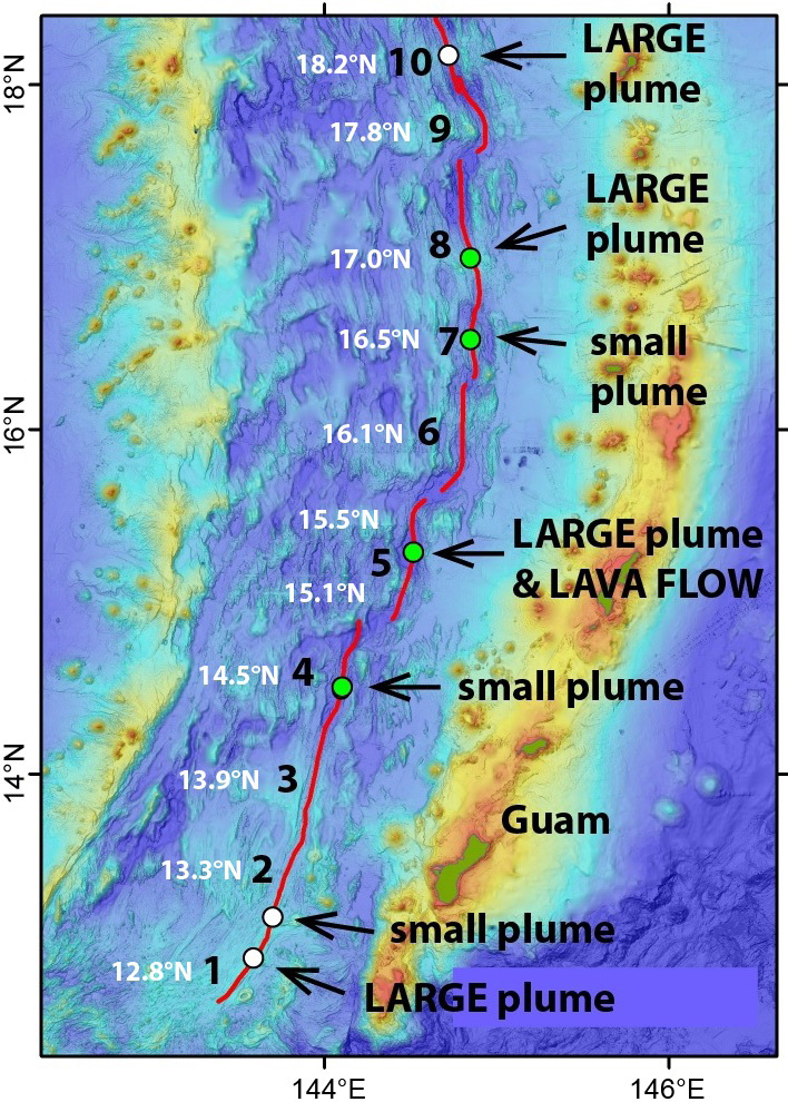 |
Figure 1. Map of the Mariana Islands (right, east) and the back-arc area (left, west), showing previous labeled map segments 1-10 and new latitude-based back-arc segment nomenclature. The new lava flows were found in the 15.5°N segment. New areas of hydrothermal venting discovered during the 2015 expedition are shown by green dots; white dots are previously known venting sites. From Merle and Chadwick (2016). |
In a brief article by Chadwick, Merle, and Anderson (2016) in the informal cruise report compiled by Merle and Chadwick (2016), the following observation was made: "One of the most surprising discoveries during the cruise was finding glassy unsedimented lava flows on the 15.5°N segment (Map 5), indicating that there had been a recent eruption on this segment." In the report, Chadwick and Resing (2016) opined that "The timing of the eruption can be constrained between multibeam sonar surveys on February 14, 2013, by R/V Melville, and December 1, 2015, when we resurveyed the site with the Falkor." Further, Chadwick, Merle, and Anderson (2016) comment that "However, the very appearance of the lava flows, the lack of sediment, and the hydrothermal venting all suggest the time since the eruption was much less than that - perhaps on the order of months. On the other hand, the lack of hydrogen in the CTD water samples over the site means that the eruption had to be older than a few weeks or a month (and that it was certainly not still ongoing)."
Chadwick, Merle, and Anderson (2016) compared the bathymetry collected by this cruise with multibeam survey data collected over the site on 14 February 2013. This comparison showed that there were seven distinct areas of significant depth changes, ranging from 38 to 127 m (figure 2). "The lava flows extend over a distance of 7.3 km, or from 15° 22.3' to 15° 26.3'N. The cross-axis width of the lava flows is 300-600 m. The depth at the eruption site ranges from 4050 m in the north to 4450 m in the south." Detailed bathymetry of the area with the new lava flows is also available (figures 3, 4, and 5).
 |
Figure 2. Outlined areas of significant positive depth changes (from 38 m on the southern-most mound to 127 m on the northern-most mound) between the 2013 and 2015 cruise surveys. From Chadwick, Merle, and Anderson (2016). |
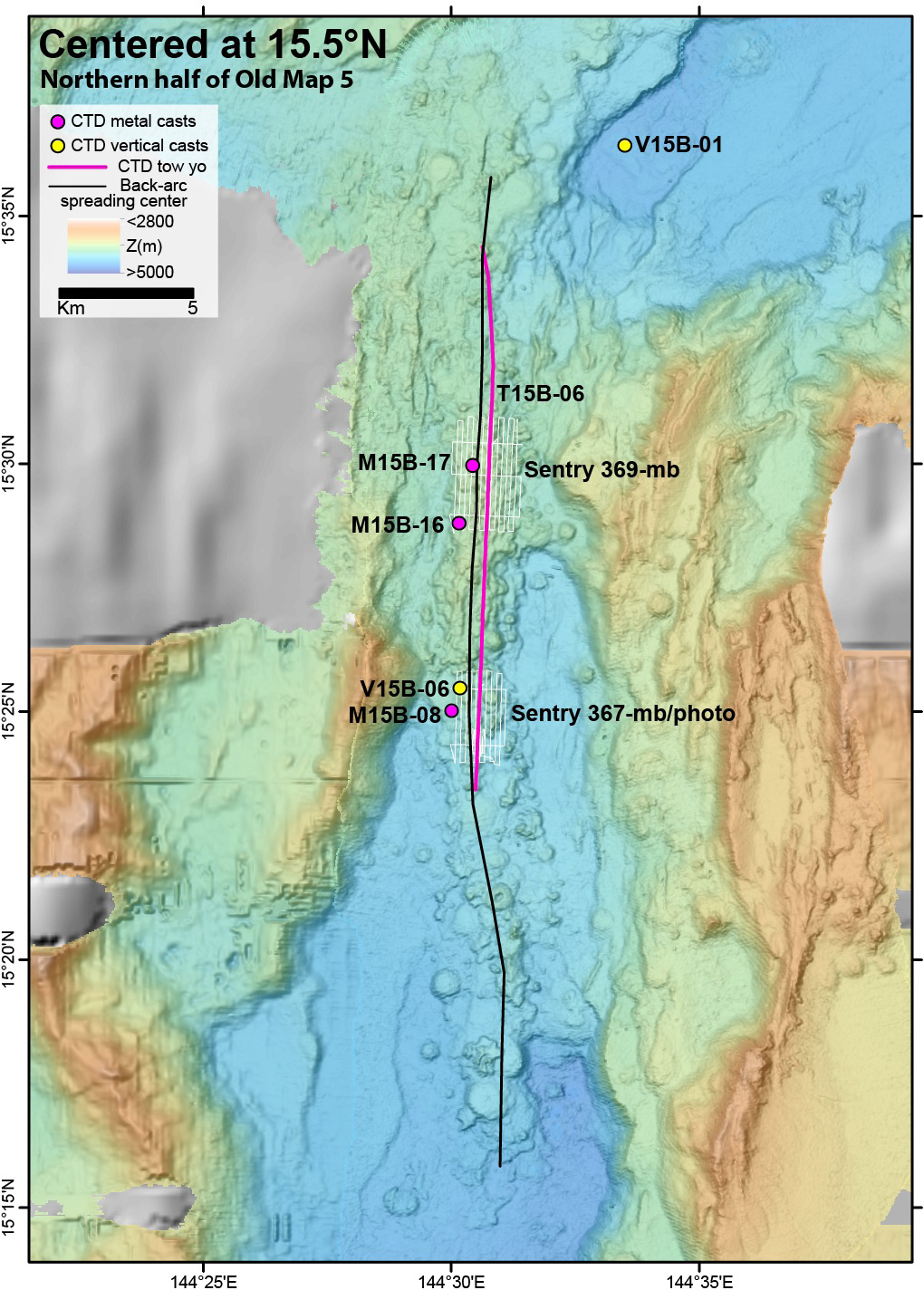 |
Figure 3. Bathymetry in the area of the new lava flows. The black line shows the location of the back-arc spreading center, the colored dots show sample casts (CTD: conductivity-temperature-depth), and the red line shows the location of a CTD tow. The location and track of the Sentry 367 dive is marked on the map. From Merle and Chadwick (2016). |
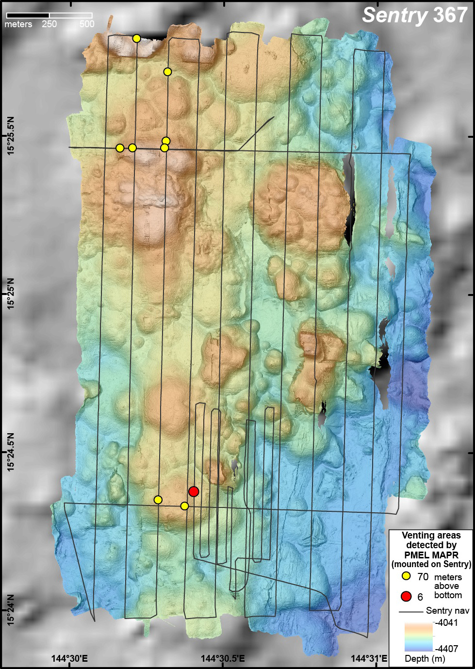 |
Figure 4. Enlargement of bathymetry in area of new lava flows showing the survey tracks of AUV Sentry 367 (black). From Merle and Chadwick (2016). |
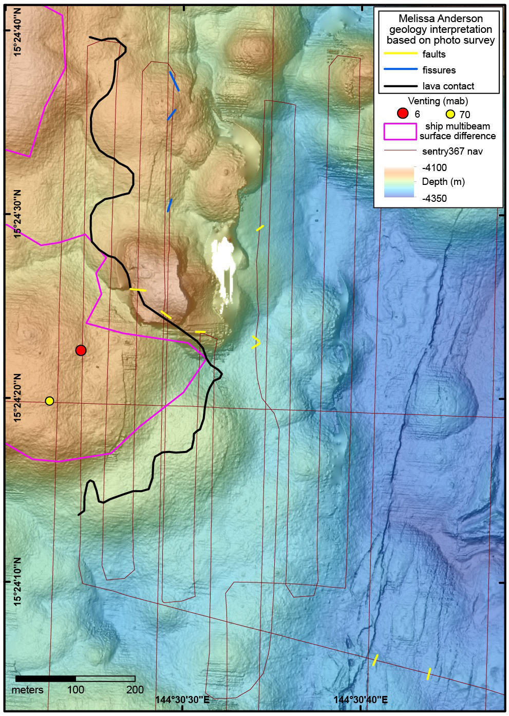 |
Figure 5. Greater enlargement of the bathymetry in the area of new lava flows showing the track of the AUV Sentry dive 367 (red). From Merle and Chadwick (2016). |
A photo survey dive conducted by the autonomous underwater vehicle (AUV) Sentry in the area showed images of "an amazingly pristine lava flow with dark glassy pillow and lobate lavas with little or no sediment on them" (figure 6). (Note that an AUV is an unmanned robot which travels underwater without requiring input from an operator.) According to Anderson (2016) in the final cruise report, "Between 15°12'N and 15°33'N, the seafloor… is dominated by relatively recent volcanism, manifested by unfaulted hummocky volcanic terrain on the basin floor bound by hummocky old arc crust."
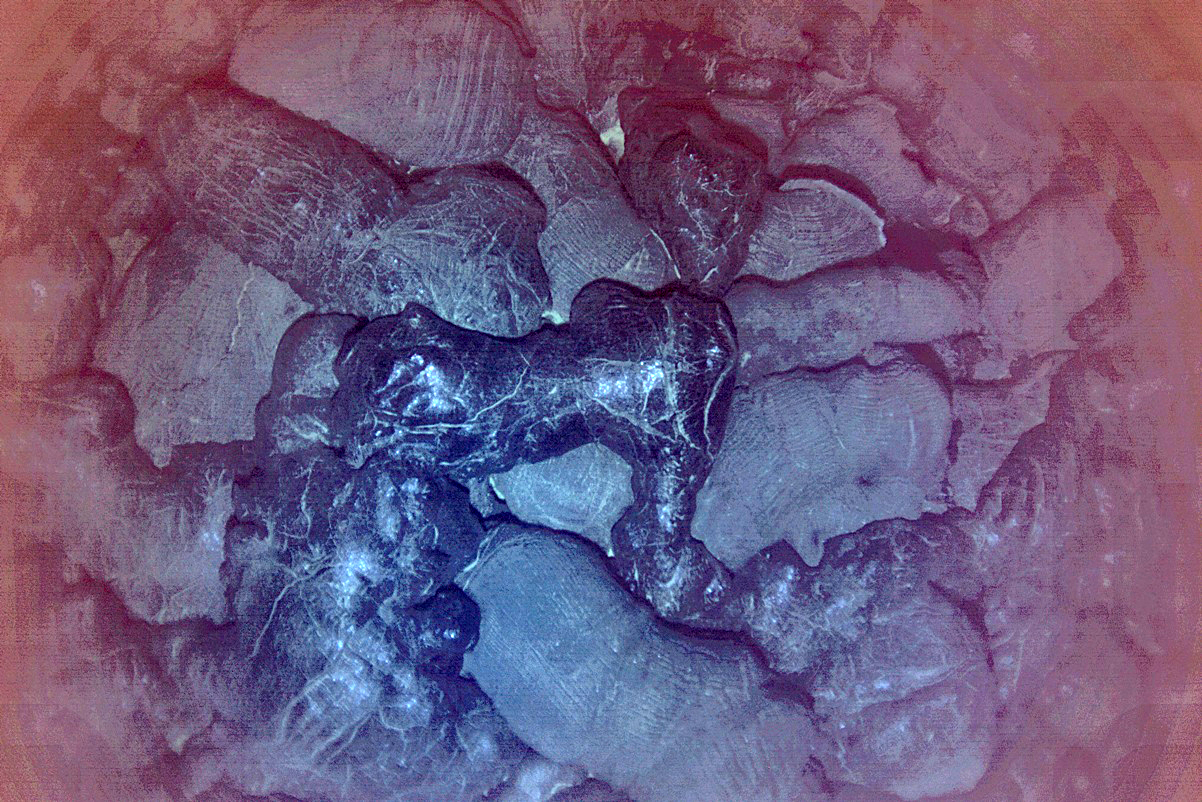 |
Figure 6. Image from the AUV Sentry of pristine lava flow with dark glassy pillow and lobate lavas with little or no sediment on them and over surrounding older seafloor (light material). Water depth was in excess of 4,000 m. From Merle and Chadwick (2016). |
References: Merle, S., and Chadwick, W. (compilers), 2016, FK151121 - Hydrothermal Hunt on the Mariana Back-arc, R/V Falkor Nov 20 - Dec 17, 2015 Guam to Guam, Chief Scientists Joseph Resing and William Chadwick, Captain Heiko Volz, Operations with CTD casts and tows, AUV Sentry dives 366-370, and seafloor mapping with EM302 multibeam sonar, informal cruise report, 103 p.
Anderson, M.O., 2016, Structures and Predicted Geology of the Mariana Back-Arc, in Merle and Chadwick (2016), p. 81-99.
Chadwick, B., and Resing, J., 2016, Expedition Summary, in Merle and Chadwick (2016), p. 2.
Chadwick, B., Merle, S., and Anderson, M., 2016, Geologic Observations and Falkor EM302 Multibeam Bathymetric Mapping, in Merle and Chadwick (2016), p. 78-80.
Information Contacts: William Chadwick, Cooperative Institute for Marine Resources Studies (CIMRS), Oregon State University, and NOAA/PMEL Earth-Ocean Interactions Program, Hatfield Marine Science Center, 2115 S.E. OSU Dr., Newport, OR 97365, USA (URL: http://www.pmel.noaa.gov/eoi/).
The Global Volcanism Program has no Weekly Reports available for Mariana Back-Arc Segment at 15.5°N.
Reports are organized chronologically and indexed below by Month/Year (Publication Volume:Number), and include a one-line summary. Click on the index link or scroll down to read the reports.
New deep sea floor lava flows observed in Mariana back-arc at 15.4°N
New lava flows were found on the deep ocean floor during Research Cruise FK151121, conducted 20 November-17 December 2015 aboard the Schmidt Ocean Institute Research Vessel (R/V) Falkor, while exploring 600 km of the Southern Mariana Back-Arc for hydrothermal anomalies (figure 1).
|
Figure 1. Map of the Mariana Islands (right, east) and the back-arc area (left, west), showing previous labeled map segments 1-10 and new latitude-based back-arc segment nomenclature. The new lava flows were found in the 15.5°N segment. New areas of hydrothermal venting discovered during the 2015 expedition are shown by green dots; white dots are previously known venting sites. From Merle and Chadwick (2016). |
In a brief article by Chadwick, Merle, and Anderson (2016) in the informal cruise report compiled by Merle and Chadwick (2016), the following observation was made: "One of the most surprising discoveries during the cruise was finding glassy unsedimented lava flows on the 15.5°N segment (Map 5), indicating that there had been a recent eruption on this segment." In the report, Chadwick and Resing (2016) opined that "The timing of the eruption can be constrained between multibeam sonar surveys on February 14, 2013, by R/V Melville, and December 1, 2015, when we resurveyed the site with the Falkor." Further, Chadwick, Merle, and Anderson (2016) comment that "However, the very appearance of the lava flows, the lack of sediment, and the hydrothermal venting all suggest the time since the eruption was much less than that - perhaps on the order of months. On the other hand, the lack of hydrogen in the CTD water samples over the site means that the eruption had to be older than a few weeks or a month (and that it was certainly not still ongoing)."
Chadwick, Merle, and Anderson (2016) compared the bathymetry collected by this cruise with multibeam survey data collected over the site on 14 February 2013. This comparison showed that there were seven distinct areas of significant depth changes, ranging from 38 to 127 m (figure 2). "The lava flows extend over a distance of 7.3 km, or from 15° 22.3' to 15° 26.3'N. The cross-axis width of the lava flows is 300-600 m. The depth at the eruption site ranges from 4050 m in the north to 4450 m in the south." Detailed bathymetry of the area with the new lava flows is also available (figures 3, 4, and 5).
|
Figure 2. Outlined areas of significant positive depth changes (from 38 m on the southern-most mound to 127 m on the northern-most mound) between the 2013 and 2015 cruise surveys. From Chadwick, Merle, and Anderson (2016). |
|
Figure 3. Bathymetry in the area of the new lava flows. The black line shows the location of the back-arc spreading center, the colored dots show sample casts (CTD: conductivity-temperature-depth), and the red line shows the location of a CTD tow. The location and track of the Sentry 367 dive is marked on the map. From Merle and Chadwick (2016). |
|
Figure 4. Enlargement of bathymetry in area of new lava flows showing the survey tracks of AUV Sentry 367 (black). From Merle and Chadwick (2016). |
|
Figure 5. Greater enlargement of the bathymetry in the area of new lava flows showing the track of the AUV Sentry dive 367 (red). From Merle and Chadwick (2016). |
A photo survey dive conducted by the autonomous underwater vehicle (AUV) Sentry in the area showed images of "an amazingly pristine lava flow with dark glassy pillow and lobate lavas with little or no sediment on them" (figure 6). (Note that an AUV is an unmanned robot which travels underwater without requiring input from an operator.) According to Anderson (2016) in the final cruise report, "Between 15°12'N and 15°33'N, the seafloor… is dominated by relatively recent volcanism, manifested by unfaulted hummocky volcanic terrain on the basin floor bound by hummocky old arc crust."
|
Figure 6. Image from the AUV Sentry of pristine lava flow with dark glassy pillow and lobate lavas with little or no sediment on them and over surrounding older seafloor (light material). Water depth was in excess of 4,000 m. From Merle and Chadwick (2016). |
References: Merle, S., and Chadwick, W. (compilers), 2016, FK151121 - Hydrothermal Hunt on the Mariana Back-arc, R/V Falkor Nov 20 - Dec 17, 2015 Guam to Guam, Chief Scientists Joseph Resing and William Chadwick, Captain Heiko Volz, Operations with CTD casts and tows, AUV Sentry dives 366-370, and seafloor mapping with EM302 multibeam sonar, informal cruise report, 103 p.
Anderson, M.O., 2016, Structures and Predicted Geology of the Mariana Back-Arc, in Merle and Chadwick (2016), p. 81-99.
Chadwick, B., and Resing, J., 2016, Expedition Summary, in Merle and Chadwick (2016), p. 2.
Chadwick, B., Merle, S., and Anderson, M., 2016, Geologic Observations and Falkor EM302 Multibeam Bathymetric Mapping, in Merle and Chadwick (2016), p. 78-80.
Information Contacts: William Chadwick, Cooperative Institute for Marine Resources Studies (CIMRS), Oregon State University, and NOAA/PMEL Earth-Ocean Interactions Program, Hatfield Marine Science Center, 2115 S.E. OSU Dr., Newport, OR 97365, USA (URL: http://www.pmel.noaa.gov/eoi/).
|
|
||||||||||||||||||
There is data available for 1 confirmed eruptive period.
2013 Feb 13 (on or after) - 2015 Dec 1 (on or before) Confirmed Eruption (Submarine) VEI: 0
| Episode 1 | Eruption (Submarine) | Along a 10 km N-S line at 15.4°N | ||||||||||||||||||
|---|---|---|---|---|---|---|---|---|---|---|---|---|---|---|---|---|---|---|---|
| 2013 Feb 13 (on or after) - 2015 Dec 1 (on or before) | Evidence from Observations: Reported | ||||||||||||||||||
| New lava flows were found on the deep ocean floor during Research Cruise FK151121, conducted 20 November-17 December 2015 aboard the Schmidt Ocean Institute Research Vessel (R/V) Falkor, while exploring 600 km of the Southern Mariana Back-Arc for hydrothermal anomalies. Chadwick, Merle, and Anderson (2016) compared the bathymetry collected by this cruise with multibeam survey data collected over the site on 14 February 2013. This comparison showed that there were seven distinct areas of significant depth changes, ranging from 38 to 127 m. The lava flows extend over a distance of 7.3 km, or from 15° 22.3' to 15° 26.3'N. The cross-axis width of the lava flows is 300-600 m. The depth at the eruption site ranges from 4,050 m in the north to 4,450 m in the south. A photo survey dive conducted by the autonomous underwater vehicle (AUV) Sentry in the area showed images of "an amazingly pristine lava flow with dark glassy pillow and lobate lavas with little or no sediment on them." | |||||||||||||||||||
|
List of 2 Events for Episode 1 at Along a 10 km N-S line at 15.4°N
|
|||||||||||||||||||
The Global Volcanism Program has no synonyms or subfeatures listed for Mariana Back-Arc Segment at 15.5°N.
The Global Volcanism Program has no photographs available for Mariana Back-Arc Segment at 15.5°N.
There are no samples for Mariana Back-Arc Segment at 15.5°N in the Smithsonian's NMNH Department of Mineral Sciences Rock and Ore collection.
| Copernicus Browser | The Copernicus Browser replaced the Sentinel Hub Playground browser in 2023, to provide access to Earth observation archives from the Copernicus Data Space Ecosystem, the main distribution platform for data from the EU Copernicus missions. |
| MIROVA | Middle InfraRed Observation of Volcanic Activity (MIROVA) is a near real time volcanic hot-spot detection system based on the analysis of MODIS (Moderate Resolution Imaging Spectroradiometer) data. In particular, MIROVA uses the Middle InfraRed Radiation (MIR), measured over target volcanoes, in order to detect, locate and measure the heat radiation sourced from volcanic activity. |
| MODVOLC Thermal Alerts | Using infrared satellite Moderate Resolution Imaging Spectroradiometer (MODIS) data, scientists at the Hawai'i Institute of Geophysics and Planetology, University of Hawai'i, developed an automated system called MODVOLC to map thermal hot-spots in near real time. For each MODIS image, the algorithm automatically scans each 1 km pixel within it to check for high-temperature hot-spots. When one is found the date, time, location, and intensity are recorded. MODIS looks at every square km of the Earth every 48 hours, once during the day and once during the night, and the presence of two MODIS sensors in space allows at least four hot-spot observations every two days. Each day updated global maps are compiled to display the locations of all hot spots detected in the previous 24 hours. There is a drop-down list with volcano names which allow users to 'zoom-in' and examine the distribution of hot-spots at a variety of spatial scales. |
|
WOVOdat
Single Volcano View Temporal Evolution of Unrest Side by Side Volcanoes |
WOVOdat is a database of volcanic unrest; instrumentally and visually recorded changes in seismicity, ground deformation, gas emission, and other parameters from their normal baselines. It is sponsored by the World Organization of Volcano Observatories (WOVO) and presently hosted at the Earth Observatory of Singapore.
GVMID Data on Volcano Monitoring Infrastructure The Global Volcano Monitoring Infrastructure Database GVMID, is aimed at documenting and improving capabilities of volcano monitoring from the ground and space. GVMID should provide a snapshot and baseline view of the techniques and instrumentation that are in place at various volcanoes, which can be use by volcano observatories as reference to setup new monitoring system or improving networks at a specific volcano. These data will allow identification of what monitoring gaps exist, which can be then targeted by remote sensing infrastructure and future instrument deployments. |
| Volcanic Hazard Maps | The IAVCEI Commission on Volcanic Hazards and Risk has a Volcanic Hazard Maps database designed to serve as a resource for hazard mappers (or other interested parties) to explore how common issues in hazard map development have been addressed at different volcanoes, in different countries, for different hazards, and for different intended audiences. In addition to the comprehensive, searchable Volcanic Hazard Maps Database, this website contains information about diversity of volcanic hazard maps, illustrated using examples from the database. This site is for educational purposes related to volcanic hazard maps. Hazard maps found on this website should not be used for emergency purposes. For the most recent, official hazard map for a particular volcano, please seek out the proper institutional authorities on the matter. |
| IRIS seismic stations/networks | Incorporated Research Institutions for Seismology (IRIS) Data Services map showing the location of seismic stations from all available networks (permanent or temporary) within a radius of 0.18° (about 20 km at mid-latitudes) from the given location of Mariana Back-Arc Segment at 15.5°N. Users can customize a variety of filters and options in the left panel. Note that if there are no stations are known the map will default to show the entire world with a "No data matched request" error notice. |
| UNAVCO GPS/GNSS stations | Geodetic Data Services map from UNAVCO showing the location of GPS/GNSS stations from all available networks (permanent or temporary) within a radius of 20 km from the given location of Mariana Back-Arc Segment at 15.5°N. Users can customize the data search based on station or network names, location, and time window. Requires Adobe Flash Player. |
| DECADE Data | The DECADE portal, still in the developmental stage, serves as an example of the proposed interoperability between The Smithsonian Institution's Global Volcanism Program, the Mapping Gas Emissions (MaGa) Database, and the EarthChem Geochemical Portal. The Deep Earth Carbon Degassing (DECADE) initiative seeks to use new and established technologies to determine accurate global fluxes of volcanic CO2 to the atmosphere, but installing CO2 monitoring networks on 20 of the world's 150 most actively degassing volcanoes. The group uses related laboratory-based studies (direct gas sampling and analysis, melt inclusions) to provide new data for direct degassing of deep earth carbon to the atmosphere. |
| EarthChem | EarthChem develops and maintains databases, software, and services that support the preservation, discovery, access and analysis of geochemical data, and facilitate their integration with the broad array of other available earth science parameters. EarthChem is operated by a joint team of disciplinary scientists, data scientists, data managers and information technology developers who are part of the NSF-funded data facility Integrated Earth Data Applications (IEDA). IEDA is a collaborative effort of EarthChem and the Marine Geoscience Data System (MGDS). |

