
The Global Volcanism Program has no activity reports available for Craters of the Moon.
The Global Volcanism Program has no Weekly Reports available for Craters of the Moon.
The Global Volcanism Program has no Bulletin Reports available for Craters of the Moon.
|
|
||||||||||||||||||||||||||
There is data available for 14 confirmed eruptive periods.
0130 BCE ± 50 years Confirmed Eruption (Explosive / Effusive) VEI: 0
| Episode 1 | Eruption (Explosive / Effusive) | South of Big Craters, near Broken Top | ||||||||||||||||||
|---|---|---|---|---|---|---|---|---|---|---|---|---|---|---|---|---|---|---|---|
| 0130 BCE ± 50 years - Unknown | Evidence from Isotopic: 14C (uncalibrated) | ||||||||||||||||||
|
List of 2 Events for Episode 1 at South of Big Craters, near Broken Top
|
|||||||||||||||||||
0260 BCE ± 25 years Confirmed Eruption (Explosive / Effusive) VEI: 0
| Episode 1 | Eruption (Explosive / Effusive) | Big Craters, Trench Mortar Flat | |||||||||||||||||||||||
|---|---|---|---|---|---|---|---|---|---|---|---|---|---|---|---|---|---|---|---|---|---|---|---|---|
| 0260 BCE ± 25 years - Unknown | Evidence from Isotopic: 14C (uncalibrated) | |||||||||||||||||||||||
|
List of 3 Events for Episode 1 at Big Craters, Trench Mortar Flat
|
||||||||||||||||||||||||
0350 BCE (?) Confirmed Eruption (Explosive / Effusive) VEI: 0
| Episode 1 | Eruption (Explosive / Effusive) | North Crater | |||||||||||||||||||||||
|---|---|---|---|---|---|---|---|---|---|---|---|---|---|---|---|---|---|---|---|---|---|---|---|---|
| 0350 BCE (?) - Unknown | Evidence from Correlation: Magnetism | |||||||||||||||||||||||
|
List of 3 Events for Episode 1 at North Crater
|
||||||||||||||||||||||||
1680 BCE ± 150 years Confirmed Eruption (Explosive / Effusive) VEI: 0
| Episode 1 | Eruption (Explosive / Effusive) | Vermillion Chasm to Minidoka-Larkspur | ||||||||||||||||||
|---|---|---|---|---|---|---|---|---|---|---|---|---|---|---|---|---|---|---|---|
| 1680 BCE ± 150 years - Unknown | Evidence from Isotopic: 14C (uncalibrated) | ||||||||||||||||||
|
List of 2 Events for Episode 1 at Vermillion Chasm to Minidoka-Larkspur
|
|||||||||||||||||||
2560 BCE ± 100 years Confirmed Eruption (Explosive / Effusive) VEI: 0
| Episode 1 | Eruption (Explosive / Effusive) | Black Top Butte | |||||||||||||||||||||||
|---|---|---|---|---|---|---|---|---|---|---|---|---|---|---|---|---|---|---|---|---|---|---|---|---|
| 2560 BCE ± 100 years - Unknown | Evidence from Isotopic: 14C (uncalibrated) | |||||||||||||||||||||||
|
List of 3 Events for Episode 1 at Black Top Butte
|
||||||||||||||||||||||||
4070 BCE ± 50 years Confirmed Eruption (Explosive / Effusive) VEI: 0
| Episode 1 | Eruption (Explosive / Effusive) | Big Cinder Butte and vents to the SE | |||||||||||||||||||||||
|---|---|---|---|---|---|---|---|---|---|---|---|---|---|---|---|---|---|---|---|---|---|---|---|---|
| 4070 BCE ± 50 years - Unknown | Evidence from Isotopic: 14C (uncalibrated) | |||||||||||||||||||||||
|
List of 3 Events for Episode 1 at Big Cinder Butte and vents to the SE
|
||||||||||||||||||||||||
4250 BCE (?) Confirmed Eruption (Explosive / Effusive) VEI: 0
| Episode 1 | Eruption (Explosive / Effusive) | Sentinel Cone | |||||||||||||||||||||||
|---|---|---|---|---|---|---|---|---|---|---|---|---|---|---|---|---|---|---|---|---|---|---|---|---|
| 4250 BCE (?) - Unknown | Evidence from Correlation: Tephrochronology | |||||||||||||||||||||||
|
List of 3 Events for Episode 1 at Sentinel Cone
|
||||||||||||||||||||||||
4600 BCE ± 100 years Confirmed Eruption (Explosive / Effusive) VEI: 0
| Episode 1 | Eruption (Explosive / Effusive) | Silent Cone | |||||||||||||||||||||||
|---|---|---|---|---|---|---|---|---|---|---|---|---|---|---|---|---|---|---|---|---|---|---|---|---|
| 4600 BCE ± 100 years - Unknown | Evidence from Isotopic: 14C (uncalibrated) | |||||||||||||||||||||||
|
List of 3 Events for Episode 1 at Silent Cone
|
||||||||||||||||||||||||
5470 BCE ± 150 years Confirmed Eruption (Explosive / Effusive) VEI: 0
| Episode 1 | Eruption (Explosive / Effusive) | Grassy Cone | |||||||||||||||||||||||
|---|---|---|---|---|---|---|---|---|---|---|---|---|---|---|---|---|---|---|---|---|---|---|---|---|
| 5470 BCE ± 150 years - Unknown | Evidence from Isotopic: 14C (uncalibrated) | |||||||||||||||||||||||
|
List of 3 Events for Episode 1 at Grassy Cone
|
||||||||||||||||||||||||
5890 BCE ± 150 years Confirmed Eruption (Explosive / Effusive) VEI: 0
| Episode 1 | Eruption (Explosive / Effusive) | NW of Echo Crater | ||||||||||||||||||
|---|---|---|---|---|---|---|---|---|---|---|---|---|---|---|---|---|---|---|---|
| 5890 BCE ± 150 years - Unknown | Evidence from Isotopic: 14C (uncalibrated) | ||||||||||||||||||
|
List of 2 Events for Episode 1 at NW of Echo Crater
|
|||||||||||||||||||
8290 BCE Confirmed Eruption (Explosive / Effusive)
| Episode 1 | Eruption (Explosive / Effusive) | ||||
|---|---|---|---|---|
| 9050 BCE - Unknown | Evidence from Isotopic: 14C (uncalibrated) | |||
| Episode 2 | Eruption (Explosive / Effusive) | ||||
|---|---|---|---|---|
| 8720 BCE - Unknown | Evidence from Isotopic: 14C (uncalibrated) | |||
| Episode 3 | Eruption (Explosive / Effusive) | ||||
|---|---|---|---|---|
| 8290 BCE - Unknown | Evidence from Isotopic: 14C (uncalibrated) | |||
8720 BCE Confirmed Eruption (Explosive / Effusive)
| Episode 1 | Eruption (Explosive / Effusive) | ||||
|---|---|---|---|---|
| 9050 BCE - Unknown | Evidence from Isotopic: 14C (uncalibrated) | |||
| Episode 2 | Eruption (Explosive / Effusive) | ||||
|---|---|---|---|---|
| 8720 BCE - Unknown | Evidence from Isotopic: 14C (uncalibrated) | |||
| Episode 3 | Eruption (Explosive / Effusive) | ||||
|---|---|---|---|---|
| 8290 BCE - Unknown | Evidence from Isotopic: 14C (uncalibrated) | |||
9050 BCE Confirmed Eruption (Explosive / Effusive)
| Episode 1 | Eruption (Explosive / Effusive) | ||||
|---|---|---|---|---|
| 9050 BCE - Unknown | Evidence from Isotopic: 14C (uncalibrated) | |||
| Episode 2 | Eruption (Explosive / Effusive) | ||||
|---|---|---|---|---|
| 8720 BCE - Unknown | Evidence from Isotopic: 14C (uncalibrated) | |||
| Episode 3 | Eruption (Explosive / Effusive) | ||||
|---|---|---|---|---|
| 8290 BCE - Unknown | Evidence from Isotopic: 14C (uncalibrated) | |||
10060 BCE Confirmed Eruption (Explosive / Effusive)
| Episode 1 | Eruption (Explosive / Effusive) | Sunset cone | |||
|---|---|---|---|---|
| 10060 BCE - Unknown | Evidence from Isotopic: 14C (uncalibrated) | |||
This compilation of synonyms and subsidiary features may not be comprehensive. Features are organized into four major categories: Cones, Craters, Domes, and Thermal Features. Synonyms of features appear indented below the primary name. In some cases additional feature type, elevation, or location details are provided.
Cones |
||||
| Feature Name | Feature Type | Elevation | Latitude | Longitude |
| Big Cinder Butte | Pyroclastic cone | 1986 m | 43° 25' 5.00" N | 113° 32' 17.00" W |
| Big Craters | Cone | 1919 m | 43° 27' 0.00" N | 113° 32' 0.00" W |
| Black Top Butte | Cone | 43° 17' 0.00" N | 113° 26' 0.00" W | |
| Broken Top | Cone | 1846 m | 43° 25' 0.00" N | 113° 31' 0.00" W |
| Coyote Butte | Cone | 1801 m | 43° 24' 0.00" N | 113° 31' 0.00" W |
| Crescent Butte | Pyroclastic cone | 1823 m | 43° 25' 0.00" N | 113° 30' 14.00" W |
| Devils Cauldron | Cone | 43° 18' 0.00" N | 113° 26' 0.00" W | |
| Echo Crater Butte | Pyroclastic cone | 1782 m | 43° 23' 35.00" N | 113° 30' 40.00" W |
| Fissure Butte | Pyroclastic cone | 1791 m | 43° 21' 7.00" N | 113° 28' 1.00" W |
| Grassy | Pyroclastic cone | 1925 m | 43° 27' 22.00" N | 113° 34' 59.00" W |
| Half Cone | Cone | 1846 m | 43° 25' 0.00" N | 113° 31' 0.00" W |
| Inferno | Cone | 1884 m | 43° 26' 0.00" N | 113° 32' 0.00" W |
| Paisley | Pyroclastic cone | 1861 m | 43° 27' 4.00" N | 113° 32' 53.00" W |
| Sentinel, The | Pyroclastic cone | 1771 m | 43° 23' 0.00" N | 113° 30' 0.00" W |
| Sheep Trail Butte | Pyroclastic cone | 1711 m | 43° 20' 46.00" N | 113° 27' 22.00" W |
| Silent Cone | Pyroclastic cone | 1938 m | 43° 26' 42.00" N | 113° 34' 8.00" W |
| Split Butte | Cone | 1737 m | 43° 22' 0.00" N | 113° 29' 0.00" W |
| Sunset | Pyroclastic cone | 1954 m | 43° 28' 8.00" N | 113° 33' 47.00" W |
| Two Point Butte | Pyroclastic cone | 1697 m | 43° 19' 52.00" N | 113° 26' 49.00" W |
| Watchman, The | Cone | 1786 m | 43° 23' 0.00" N | 113° 29' 0.00" W |
Craters |
||||
| Feature Name | Feature Type | Elevation | Latitude | Longitude |
| Great Rift Zone | Fissure vent | 1800 m | 43° 20' 0.00" N | 113° 28' 0.00" W |
| North Crater | Crater - Cone | 1903 m | 43° 27' 11.00" N | 113° 33' 43.00" W |
| Vermillion Chasm | Fissure vent | 1664 m | 43° 20' 0.00" N | 113° 28' 0.00" W |
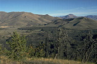 The Highway lava flow forming the black lobe in the center of the photo at the base of the Pioneer Mountains was erupted about 2300 years ago from a vent at or near North Crater, out of view to the right. Two other Craters of the Moon flows, the Devils Orchard and Serrate lava flows, were also erupted at about the same time. The complex vegetated cinder cone to the right of the Highway lava flow is the late Pleistocene Sunset Cone.
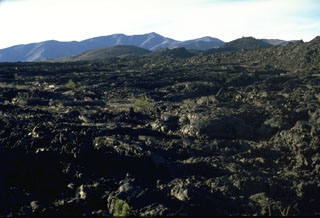 The Blue Dragon lava flow covers about 280 km2 of Craters of the Moon lava field with flat-lying pahoehoe lava. The 3.4 cu km flow, erupted about 2075 years ago, is the largest in the Craters of the Moon volcanic field. It traveled up to 25 km to the east and 15 km to the SW from fissure vents near the center of this photo. The largely pahoehoe lava flow is named for a characteristic iridescent dark- to light-blue, glassy crust.
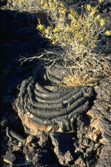 The ropy surface of pahoehoe lava flows is the dominant lava type at Craters of the Moon. The pahoehoe flows were typically erupted through lava tubes and tube systems. Locally collapse of tube roofs has formed skylights and entrances to lava tunnels that are popular among visitors to the national monument.
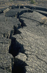 Pressure ridges, formed when moving, still-fluid magma buckled the solidified surfaces of pahoehoe lava flows, are one of the many lava flow features easily observed at Craters of the Moon National Monument in Idaho.
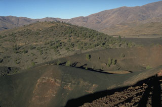 Silent Cone, the partially forested cinder cone in the background, was the source of lava flows primarily to the south about 6500 years ago. The well-preserved cone of Big Craters in the foreground is one of the youngest features of Craters of the Moon.
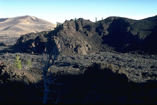 The Big Craters lava flow in the foreground, one of the youngest at the Craters of the Moon, originated about 2200 years ago from vents at the northern base of Big Craters. The flows traveled north before being deflected by the slopes of the Pioneer Mountains in the background and then flowed primarily to the SW.
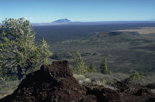 The vast extent of the Blue Dragon lava flow, forming the flat area in the middle of the photo, can be appreciated in this view from Big Cinder Butte with Big Southern Butte in the background to the east. The Blue Dragon flow, the largest volume lava flow at Craters of the Moon, covers 280 km2 with 3.4 cu km of lava. The flow was erupted about 2075 years ago and covers broad areas as far as 25 km to the east and 15 km to the SW of its vent area.
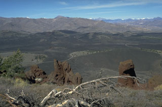 The Craters of the Moon lava field covers 1600 km2 of the Snake River Plain with lava flows erupted from NW-SE-trending fissures and cinder cones. The northern part of the lava field, seen from Big Cinder Butte with the Pioneer Mountains in the background to the north, contains many flows and cinder cones formed during the most recent eruptions about 2300 to 2100 years ago.
There are no samples for Craters of the Moon in the Smithsonian's NMNH Department of Mineral Sciences Rock and Ore collection.
| Copernicus Browser | The Copernicus Browser replaced the Sentinel Hub Playground browser in 2023, to provide access to Earth observation archives from the Copernicus Data Space Ecosystem, the main distribution platform for data from the EU Copernicus missions. |
| MIROVA | Middle InfraRed Observation of Volcanic Activity (MIROVA) is a near real time volcanic hot-spot detection system based on the analysis of MODIS (Moderate Resolution Imaging Spectroradiometer) data. In particular, MIROVA uses the Middle InfraRed Radiation (MIR), measured over target volcanoes, in order to detect, locate and measure the heat radiation sourced from volcanic activity. |
| MODVOLC Thermal Alerts | Using infrared satellite Moderate Resolution Imaging Spectroradiometer (MODIS) data, scientists at the Hawai'i Institute of Geophysics and Planetology, University of Hawai'i, developed an automated system called MODVOLC to map thermal hot-spots in near real time. For each MODIS image, the algorithm automatically scans each 1 km pixel within it to check for high-temperature hot-spots. When one is found the date, time, location, and intensity are recorded. MODIS looks at every square km of the Earth every 48 hours, once during the day and once during the night, and the presence of two MODIS sensors in space allows at least four hot-spot observations every two days. Each day updated global maps are compiled to display the locations of all hot spots detected in the previous 24 hours. There is a drop-down list with volcano names which allow users to 'zoom-in' and examine the distribution of hot-spots at a variety of spatial scales. |
|
WOVOdat
Single Volcano View Temporal Evolution of Unrest Side by Side Volcanoes |
WOVOdat is a database of volcanic unrest; instrumentally and visually recorded changes in seismicity, ground deformation, gas emission, and other parameters from their normal baselines. It is sponsored by the World Organization of Volcano Observatories (WOVO) and presently hosted at the Earth Observatory of Singapore.
GVMID Data on Volcano Monitoring Infrastructure The Global Volcano Monitoring Infrastructure Database GVMID, is aimed at documenting and improving capabilities of volcano monitoring from the ground and space. GVMID should provide a snapshot and baseline view of the techniques and instrumentation that are in place at various volcanoes, which can be use by volcano observatories as reference to setup new monitoring system or improving networks at a specific volcano. These data will allow identification of what monitoring gaps exist, which can be then targeted by remote sensing infrastructure and future instrument deployments. |
| Volcanic Hazard Maps | The IAVCEI Commission on Volcanic Hazards and Risk has a Volcanic Hazard Maps database designed to serve as a resource for hazard mappers (or other interested parties) to explore how common issues in hazard map development have been addressed at different volcanoes, in different countries, for different hazards, and for different intended audiences. In addition to the comprehensive, searchable Volcanic Hazard Maps Database, this website contains information about diversity of volcanic hazard maps, illustrated using examples from the database. This site is for educational purposes related to volcanic hazard maps. Hazard maps found on this website should not be used for emergency purposes. For the most recent, official hazard map for a particular volcano, please seek out the proper institutional authorities on the matter. |
| IRIS seismic stations/networks | Incorporated Research Institutions for Seismology (IRIS) Data Services map showing the location of seismic stations from all available networks (permanent or temporary) within a radius of 0.18° (about 20 km at mid-latitudes) from the given location of Craters of the Moon. Users can customize a variety of filters and options in the left panel. Note that if there are no stations are known the map will default to show the entire world with a "No data matched request" error notice. |
| UNAVCO GPS/GNSS stations | Geodetic Data Services map from UNAVCO showing the location of GPS/GNSS stations from all available networks (permanent or temporary) within a radius of 20 km from the given location of Craters of the Moon. Users can customize the data search based on station or network names, location, and time window. Requires Adobe Flash Player. |
| DECADE Data | The DECADE portal, still in the developmental stage, serves as an example of the proposed interoperability between The Smithsonian Institution's Global Volcanism Program, the Mapping Gas Emissions (MaGa) Database, and the EarthChem Geochemical Portal. The Deep Earth Carbon Degassing (DECADE) initiative seeks to use new and established technologies to determine accurate global fluxes of volcanic CO2 to the atmosphere, but installing CO2 monitoring networks on 20 of the world's 150 most actively degassing volcanoes. The group uses related laboratory-based studies (direct gas sampling and analysis, melt inclusions) to provide new data for direct degassing of deep earth carbon to the atmosphere. |
| Large Eruptions of Craters of the Moon | Information about large Quaternary eruptions (VEI >= 4) is cataloged in the Large Magnitude Explosive Volcanic Eruptions (LaMEVE) database of the Volcano Global Risk Identification and Analysis Project (VOGRIPA). |
| EarthChem | EarthChem develops and maintains databases, software, and services that support the preservation, discovery, access and analysis of geochemical data, and facilitate their integration with the broad array of other available earth science parameters. EarthChem is operated by a joint team of disciplinary scientists, data scientists, data managers and information technology developers who are part of the NSF-funded data facility Integrated Earth Data Applications (IEDA). IEDA is a collaborative effort of EarthChem and the Marine Geoscience Data System (MGDS). |

