The Global Volcanism Program has no activity reports available for Pueblo Nuevo Viñas.
The Global Volcanism Program has no Weekly Reports available for Pueblo Nuevo Viñas.
The Global Volcanism Program has no Bulletin Reports available for Pueblo Nuevo Viñas.
|
|
||||||||||||||||||
The Global Volcanism Program is not aware of any Holocene eruptions from Pueblo Nuevo Viñas. If this volcano has had large eruptions (VEI >= 4) prior to 12,000 years ago, information might be found on the Pueblo Nuevo Viñas page in the LaMEVE (Large Magnitude Explosive Volcanic Eruptions) database, a part of the Volcano Global Risk Identification and Analysis Project (VOGRIPA).
This compilation of synonyms and subsidiary features may not be comprehensive. Features are organized into four major categories: Cones, Craters, Domes, and Thermal Features. Synonyms of features appear indented below the primary name. In some cases additional feature type, elevation, or location details are provided.
Synonyms |
||||
| Gambia, Volcán la | Gabia, Cerro la | ||||
Cones |
||||
| Feature Name | Feature Type | Elevation | Latitude | Longitude |
| Guznayal, Cerro el | Pyroclastic cone | 940 m | 14° 13' 0.00" N | 90° 34' 0.00" W |
| Redondo, Cerro Monte | Pyroclastic cone | 830 m | 14° 14' 0.00" N | 90° 33' 0.00" W |
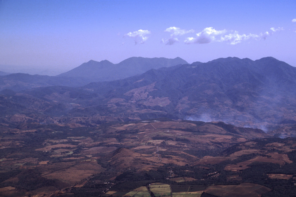
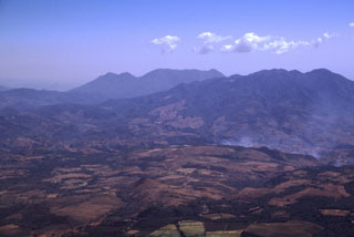 The deeply eroded Plio-Pleistocene stratovolcano at the upper right is Pueblo Nuevo Viñas (also known as Cerro la Gabia). Four scoria cones are located on the NE flank, and lava flows from the volcano cover the western portion of the Cuilapa quadrangle. This view is from the NW at the summit of Pacaya volcano with Tecuamburro volcano on the center horizon. Flank activity from Tecuamburro has occurred as recently as about 3,000 years ago.
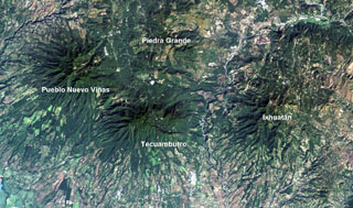 Four large Pleistocene volcanic complexes are visible in this Landsat image of southern Guatemala, with the Pacific coastal plain at the bottom. Minor activity at Tecuamburro volcano continued into the Holocene at Laguna Ixpaco, the small circular white dot a little more than half-way between the Tecuamburro and Piedra Grande labels. The Río los Esclavos extends from the upper right, cutting between Tecuamburro and Ixhuatán volcanoes.
There are no samples for Pueblo Nuevo Viñas in the Smithsonian's NMNH Department of Mineral Sciences Rock and Ore collection.
| Copernicus Browser | The Copernicus Browser replaced the Sentinel Hub Playground browser in 2023, to provide access to Earth observation archives from the Copernicus Data Space Ecosystem, the main distribution platform for data from the EU Copernicus missions. |
|
WOVOdat
Single Volcano View Temporal Evolution of Unrest Side by Side Volcanoes |
WOVOdat is a database of volcanic unrest; instrumentally and visually recorded changes in seismicity, ground deformation, gas emission, and other parameters from their normal baselines. It is sponsored by the World Organization of Volcano Observatories (WOVO) and presently hosted at the Earth Observatory of Singapore.
GVMID Data on Volcano Monitoring Infrastructure The Global Volcano Monitoring Infrastructure Database GVMID, is aimed at documenting and improving capabilities of volcano monitoring from the ground and space. GVMID should provide a snapshot and baseline view of the techniques and instrumentation that are in place at various volcanoes, which can be use by volcano observatories as reference to setup new monitoring system or improving networks at a specific volcano. These data will allow identification of what monitoring gaps exist, which can be then targeted by remote sensing infrastructure and future instrument deployments. |
| IRIS seismic stations/networks | Incorporated Research Institutions for Seismology (IRIS) Data Services map showing the location of seismic stations from all available networks (permanent or temporary) within a radius of 0.18° (about 20 km at mid-latitudes) from the given location of Pueblo Nuevo Viñas. Users can customize a variety of filters and options in the left panel. Note that if there are no stations are known the map will default to show the entire world with a "No data matched request" error notice. |
| UNAVCO GPS/GNSS stations | Geodetic Data Services map from UNAVCO showing the location of GPS/GNSS stations from all available networks (permanent or temporary) within a radius of 20 km from the given location of Pueblo Nuevo Viñas. Users can customize the data search based on station or network names, location, and time window. Requires Adobe Flash Player. |
| Large Eruptions of Pueblo Nuevo Viñas | Information about large Quaternary eruptions (VEI >= 4) is cataloged in the Large Magnitude Explosive Volcanic Eruptions (LaMEVE) database of the Volcano Global Risk Identification and Analysis Project (VOGRIPA). |
| EarthChem | EarthChem develops and maintains databases, software, and services that support the preservation, discovery, access and analysis of geochemical data, and facilitate their integration with the broad array of other available earth science parameters. EarthChem is operated by a joint team of disciplinary scientists, data scientists, data managers and information technology developers who are part of the NSF-funded data facility Integrated Earth Data Applications (IEDA). IEDA is a collaborative effort of EarthChem and the Marine Geoscience Data System (MGDS). |

