PVMBG reported that during 1 July-31 October gas plumes from Egon rose no higher than 100 m above the crater. Seismicity decreased and was dominated by signals indicating emissions. The Alert Level was lowered to 1 (on a scale of 1-4) on 1 November.
Source: Pusat Vulkanologi dan Mitigasi Bencana Geologi (PVMBG, also known as CVGHM)
Volcanic earthquake swarms in late March and early April 2010
Following a phreatic eruption on 15 April 2008, Egon was relatively quiet for a year, prompting the Center of Volcanology and Geological Hazard Mitigation (CVGHM) to lower the Alert Level from 2 to 1 on 16 July 2009 (BGVN 34:10). This report notes seismicity and steaming between July 2009 and June 2010.
Egon (figure 1) apparently remained quiet until late March 2010, with an average of one or two daily volcanic earthquakes during January-March. Instruments then recorded a volcanic swarm, with as many as 122 events (amplitudes up to 12 mm, durations up to 45 seconds) during the last few days of March. A volcanic swarm also occurred during the week 31 March-6 April, with 26 events (amplitudes up to 4 mm, durations up to 72 seconds). Since 6 April 2010, small steam plumes rose 10 m above the crater and drifted W.
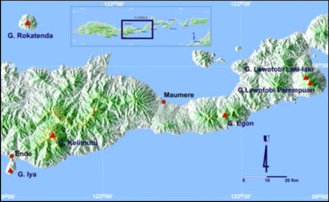 |
Figure 1. A shaded-relief map showing the location of Egon on central Flores Island (upper box) and a more detailed view of the elongate island and some active volcanoes (solid trianges). Courtesy of CVGHM. |
Egon is monitored from the village of Nangatobong, near the island's N coast ~ 6 km NNW of the summit.During the last year and as recent as mid-2010, MODVOLC thermal alerts had been absent.
Information Contacts: Center of Volcanology and Geological Hazard Mitigation (CVGHM), Saut Simatupang, 57, Bandung 40122, Indonesia (URL: http://vsi.esdm.go.id/); Hawai'i Institute of Geophysics and Planetology (HIGP) Thermal Alerts System, School of Ocean and Earth Science and Technology (SOEST), Univ. of Hawai'i, 2525 Correa Road, Honolulu, HI 96822, USA (URL: http://modis.higp.hawaii.edu/).
2016: January
| November
2015: December
2011: June
2010: April
2009: July
2008: April
| May
2005: February
| March
2004: January
| February
| June
| July
| August
| September
PVMBG reported that during 1 July-31 October gas plumes from Egon rose no higher than 100 m above the crater. Seismicity decreased and was dominated by signals indicating emissions. The Alert Level was lowered to 1 (on a scale of 1-4) on 1 November.
Source: Pusat Vulkanologi dan Mitigasi Bencana Geologi (PVMBG, also known as CVGHM)
PVMBG reported that during 20 January-1 February seismicity at Egon was dominated by signals indicating emissions; shallow volcanic events had decreased. RSAM values increased on 25 January but did not exceed values detected during the previous peak on 12 January; overall seismicity had declined. The Alert Level was lowered to 2 (on a scale of 1-4) and residents were advised to stay at least 1.5 km away from the crater.
Source: Pusat Vulkanologi dan Mitigasi Bencana Geologi (PVMBG, also known as CVGHM)
PVMBG reported that during 1-12 January seismicity at Egon was dominated by shallow volcanic tremor, harmonic tremor, and signals indicating emissions. Seismicity had increased on 15 December 2015, and then fluctuated through 11 January. RSAM increased significantly on 12 January due to an earthquake detected at 0936. PVMBG noted that the pattern of seismicity was similar to that observed before a phreatic eruption on 15 April 2008. The Alert Level was raised to 2 (on a scale of 1-4) and residents were advised to stay at least 3 km away from the crater.
On 20 January BNPB reported that activity increased again, prompting the PVMBG to raise the Alert Level to 3. The report noted that access to the Mapitara district was closed due to a strong sulfur dioxide odor in that area, and that 927 people living within 3 km of the volcano had been evacuated (501 people refused to evacuate). Diffuse white plumes rose as high as 50 m above the crater.
Sources: Pusat Vulkanologi dan Mitigasi Bencana Geologi (PVMBG, also known as CVGHM); Badan Nacional Penanggulangan Bencana (BNPB)
PVMBG reported that during October-November seismicity at Egon was at baseline levels, characterized by an average of one event per day of both deep and shallow volcanic earthquakes. On 15 December the network recorded 29 shallow volcanic earthquakes, a number significantly above baseline. PVMBG raised the Alert Level to 2 (on a scale of 1-4) that same day and advised residents and tourists to stay at least 1.5 km away from the crater.
Source: Pusat Vulkanologi dan Mitigasi Bencana Geologi (PVMBG, also known as CVGHM)
CVGHM reported that on 17 June the Alert Level for Egon was lowered to 1 (on a scale of 1-4) because seismicity had decreased and emission heights had been lower since January.
Source: Pusat Vulkanologi dan Mitigasi Bencana Geologi (PVMBG, also known as CVGHM)
CVGHM reported that on 7 April the Alert Level for Egon was raised from 1 to 2 (on a scale of 1-4) due to a marked increase in seismic activity since 28 March. Small steam plumes normally rose 10 m above the crater.
Source: Pusat Vulkanologi dan Mitigasi Bencana Geologi (PVMBG, also known as CVGHM)
CVGHM reported that the Alert Level for Egon was lowered to 1 (on a scale of 1-4) on 16 July due to the continued decrease in earthquake activity since 12 May. Small steam plumes were occasionally visible when the weather was clear.
Source: Pusat Vulkanologi dan Mitigasi Bencana Geologi (PVMBG, also known as CVGHM)
CVGHM reported that plume altitudes and seismicity from Egon decreased during 25 April-10 May. On 12 May, small steam plumes were visible. The Alert Level was lowered from 3 to 2 (on a scale of 1-4).
Source: Pusat Vulkanologi dan Mitigasi Bencana Geologi (PVMBG, also known as CVGHM)
CVGHM reported that white plumes from Egon continued to rise to an altitude of 1.8 km (5,900 ft) a.s.l. during 4-14 April. A peak in seismicity was reached during 6-7 April and then declined significantly during 7-15 April. On 15 April, a phreatic explosion produced an ash plume that rose to an altitude of 5.7 km (18,700 ft) a.s.l. and drifted about 25 km W, reaching the town of Maumere. A team of emergency personnel in the closest village to the explosion reported that about 600 people evacuated. CVGHM raised the Alert Level to 3 (on a scale of 1-4).
Source: Pusat Vulkanologi dan Mitigasi Bencana Geologi (PVMBG, also known as CVGHM)
The Darwin VAAC reported that DVGHM reduced the Alert Level at Egon to 3 (on a scale of 1-4) around 8 March. Ash was not visible on satellite imagery during 2-8 March.
Source: Darwin Volcanic Ash Advisory Centre (VAAC)
During 25-27 February, ash plumes from Egon rose to low levels above the volcano and seismicity was dominated by shallow volcanic earthquakes. Egon remained at Alert Level 4, the highest hazard status.
Source: Pusat Vulkanologi dan Mitigasi Bencana Geologi (PVMBG, also known as CVGHM)
According to a news report, as of 17 February recent eruptive activity at Egon had prompted the local government to evacuate hundreds of residents living near the volcano.
Source: The Jakarta Post
An explosion at Egon on 14 February at 1830 produced a plume to an unknown height. Egon remained at Alert Level 4, the highest level.
Source: Pusat Vulkanologi dan Mitigasi Bencana Geologi (PVMBG, also known as CVGHM)
An eruption at Egon on 6 February at 0103 led DVGHM to raise the Alert Level to 4 (the highest level) on the following day. The eruption was preceded by an increase in tremor, and consisted of the ejection of "glowing lava" and lapilli-sized material deposited on the volcano's S flank. An eruption occurred on 7 February at 1302 that was similar in size to the 6 February eruption. Before and after the 7 February eruption there was a strong scent of sulfur in the villages of Hebing and Hale. One villager was knocked unconscious due to the gas. All of the vegetation along a fissure on the volcano's S flank had died, also indicating that there was a strong gas emission.
Source: Pusat Vulkanologi dan Mitigasi Bencana Geologi (PVMBG, also known as CVGHM)
A news article reported that an eruption at Egon on 13 September produced an ash plume that drifted ~70 km downwind according to an Indonesian volcanologist. No ash was visible on satellite imagery. There were no reports of injuries or deaths. About 2,200 villagers living on the volcano's slopes had been evacuated since July 2004. Many of the evacuees reported experiencing respiratory problems and skin irritation. The airport in the town of Maumere was closed due to up to 1 cm of ash deposited on facilities and equipment.
Sources: Associated Press; The Jakarta Post; Darwin Volcanic Ash Advisory Centre (VAAC)
Strong volcanic activity at Egon beginning on 3 September led DVGHM to raise the Alert Level from 3 to 4 (on a scale of 1-4) on 4 September. The increase in volcanic activity began on 27 August when plumes rose to ~300 m above the volcano and explosion earthquakes were recorded. This activity prompted DVGHM to raise the Alert Level from 2 to 3. On 3 September an ash plume rose ~1 km above the summit and on 4 September an ash plume rose to ~3 km. As a consequence, all those living in the villages of Baokrengit, Welimwatu, and Natakoli were evacuated. On 6 September, an explosion produced a plume as high as 2.5 km above the volcano that drifted SW. According to a report released by the United Nations Office for the Coordination of Humanitarian Affairs (OCHA), as of 6 September activity at Egon led to the evacuation of 2,100 people. A total of 4,300 were expected to be evacuated.
Sources: Pusat Vulkanologi dan Mitigasi Bencana Geologi (PVMBG, also known as CVGHM); UN Office for the Coordination of Humanitarian Affairs (OCHA)
According to news articles, increased volcanic activity at Egon on 31 August led people from at least seven villages near the volcano to temporarily evacuate their homes. Local officials feared that about 2,000 people living on the mountainside were at risk. Reportedly, activity decreased after a few hours and most villagers returned home.
Sources: ABC News - Australian Broadcasting Corporation; The Jakarta Post
According to DVGHM, an eruption began at Egon on 25 July at 2240, consisting of loud rumbling sounds, a strong sulfur scent, and explosions that rose to 1-1.5 km above the summit. A thick, black plume drifted NNW from the volcano. Interpretations of seismic data revealed that the eruption lasted about 2.5 hours. According to the Darwin VAAC, a plume was visible on satellite imagery. DVGHM reported that about 630 residents near Egon self evacuated from the villages of Egon, Nangatobong, and Itoper. According to a news article, about 1,400 people evacuated. At 1500 on 26 July seismographs recorded nearly continuous explosions produced plumes to ~250 m above the volcano.
Sources: Agence France-Presse (AFP); Pusat Vulkanologi dan Mitigasi Bencana Geologi (PVMBG, also known as CVGHM); Darwin Volcanic Ash Advisory Centre (VAAC)
During 5-11 July, observers watching Egon volcano saw it emit white plumes of variable density that typically rose 25-75 m above the summit. The seismograph recorded a continuous series of 'emission earthquakes' with amplitudes of 2 mm. Egon's hazard status remained at Alert Level 2 (on a scale of 1-4).
Source: Pusat Vulkanologi dan Mitigasi Bencana Geologi (PVMBG, also known as CVGHM)
According to news articles, increased volcanic activity began at Egon on 3 July. Ash from an explosion on the night of the 3rd drifted as far W as Maumere, the capital of Flores. About 2,000 residents near the volcano were evacuated. The four villages worst affected were Egon Gahar, Natakoli, Hale, and Hebing. According to DVGHM, two small explosions occurred at Egon, producing ash clouds to heights of ~150 m. Egon was listed at Alert Level 2 (on a scale of 1-4).
Sources: Pusat Vulkanologi dan Mitigasi Bencana Geologi (PVMBG, also known as CVGHM); The Jakarta Post
According to a news report, local scientists found that volcanic activity that began with an eruption at Egon on 29 January had significantly decreased around 5 February. More than 1,000 of the ~5,600 residents who were evacuated from near the volcano returned home on the 5th.
Source: The Jakarta Post
Volcanic activity began at Egon on 29 January around 0400 when a landslide traveled down the volcano's E crater wall. Around 1700 an explosion produced a black ash cloud to a height of ~750 m above the summit. During 30-31 January, loud noises from the volcano were followed by emissions of gray ash clouds. In addition, there was a strong scent of sulfur every 50-60 minutes. Visual observations on the 31st revealed that a new solfatara tunnel (sulfur-rich fumarole) was created on the S side of the volcano. Small volcanic earthquakes, deep-volcanic earthquakes, and harmonic tremor were recorded. DVGHM put Egon at Alert Level 3 (on a scale of 1-4) beginning on 2 February. The volcano did not previously have an Alert Level. The Darwin VAAC reported that ash was not visible on satellite imagery.
The volcanism at Egon led to the evacuation of residents near the volcano on 29 January. According to a report by the United Nations Office for the Coordination of Humanitarian Affairs (OCHA), local authorities ordered the evacuation of the villages of Hale, Hebing, Egon Gahar, and Natakoli, which were in high-risk areas on the S side of the volcano. By 31 Jan, ~3,900 people had reached Maumere city, ~35 km away. As many as 6,000 people were evacuated by 1 February. At least one death was reported, although it was not clear if it resulted from the volcanic activity, evacuation process, or other causes. According to news reports, many of the evacuees suffered from respiratory problems, dengue fever, malaria, and diarrhea. There were also reports of looting in the evacuated villages.
Sources: Pusat Vulkanologi dan Mitigasi Bencana Geologi (PVMBG, also known as CVGHM); UN Office for the Coordination of Humanitarian Affairs (OCHA); Darwin Volcanic Ash Advisory Centre (VAAC); Khaleej Times; The Jakarta Post
Reports are organized chronologically and indexed below by Month/Year (Publication Volume:Number), and include a one-line summary. Click on the index link or scroll down to read the reports.
29 January brings sudden eruptive onset, prompting rapid evacuations
This first Bulletin report discussing Egon describes the sudden appearance of volcanic activity there in January 2004. Heavy rains fell over Egon and its surrounding area on 28 January. At 0400 on 29 January, local people heard the sound of the E crater wall collapsing inward. That was followed at 1700 by an explosion and a black ash cloud rising ~ 750 m above the summit. On 30-31 January further noise was followed by gray ash clouds and the odor of highly concentrated sulfur every 50-60 minutes. Visual observation on 31 January revealed a new solfatara.
Volcanic earthquakes were detected on 30 January (intensity III on the Modified Mercali (MMI) scale), and a seismometer installed on 31 January recorded a type-A deep-volcanic earthquake at 1610 and two harmonic tremor events (amplitude 0.5 mm) at 1800. At 2227 an explosion was heard and instrumentally recorded for about 70 seconds. On 1 February, instruments recorded two tremor events and one type-A volcanic earthquake. Egon was placed on Alert level 3 (on a 1-4 scale) on that day.
United Nations reports and news reports from around 31 January indicated that up to 6,400 people were being evacuated from near Egon volcano as a precautionary measure due to "smoke," ash, and other possible emissions. The news cited evacuations from the mountain villages of Hale, Hebing, Lere, Natakoli, Pedat, Bau Krengat, and Kelawair, with refugees going to Maumere (the island's main town, 25 km W of the summit). There were reports of 1 or 2 deaths, but it is not entirely clear that they were related to volcanic activity, evacuations, or other causes.
The European Volcanological Society (SVE) posted this report on the UN's Relief Web website: "One person has been reported killed from smoke and ash inhalation from the eruption of Egon volcano. Thick clouds of smoke and a great discharge of hot ash, large chunks of sulfur and volcanic rocks were seen nearby. The eruption caused panic among residents nearby, and they fled the mountain villages . . . . Eyewitnesses said the lower part of the crater was seen bursting and that was believed to be the main outlet for the hot lava that spewed from the volcano.."
Agence France-Presse published a photo (by Romeo Gacad) with a distant aerial view of Egon's summit as it appeared around sunset on 1 February. A thin plume rose gently above the summit. Lower portions of the photo were in cloud.
A 2 February 2004 United Nations (OCHA) report stated that "Volcanologists continue monitoring the activity of Mt. Egon closely. Since the beginning of February, a decrease in seismic activity and emissions has been registered." This and another UN report noted, as of 13 February ~ 5,000 people had been evacuated and had been accommodated in 14 temporary government shelters. The report went on to note "A gradual return of the evacuated population has already begun and is expected to continue if current conditions remain unchanged. As of 4 February some 600 people have already returned to their villages."
Information Contacts: Dali Ahmad, Hetty Triastuty, Nia Haerani, and Suswati, Directorate of Volcanology and Geological Hazards (formerly VSI), Jalan Diponegoro No 57, Bandung 40122, Indonesia (URL: http://www.vsi.esdm.go.id/); Dan Shackelford, 3124 E. Yorba Linda Blvd., Apt. H-33, Fullerton, CA 92831-2324, USA; United Nations, Office for the Coordination of Humanitarian Affairs (UN OCHA), S-3600, New York, NY 10017, USA (URL: https://reliefweb.int/); Henry Gaudru, Société Volcanologique Européenne (SVE), C.P.1-1211 Geneva 17- Switzerland (URL: http://www.sveurop.org/).
Explosive ash eruptions in July and August; ashfall and evacuations
Volcanic activity began at Egon in late January when ash explosions caused local ashfall (BGVN 29:03). Activity subsequently decreased, and evacuated residents returned home. Reports from the Directorate of Volcanology and Geological Hazard Mitigation (DVGHM) indicated that in May 2004 only ten A-type volcanic earthquakes were detected. These types of events increased to 19 during June, when three shallow B-type volcanic earthquakes were also registered (table 1).
Table 1. Seismicity at Egon during 20 June-29 August 2004. Courtesy of DVGHM.
| Date | Volcanic A | Volcanic B | Tremor | Tectonic |
| 20 Jun-27 Jun 2004 | 7 | 2 | -- | 23 |
| 28 Jun-04 Jul 2004 | 9 | 3 | -- | 24 |
| 05 Jul-11 Jul 2004 | 9 | 2 | continuous | 2 |
| 12 Jul-18 Jul 2004 | 22 | 139 | 2 | 35 |
| 19 Jul-25 Jul 2004 | 17 | 109 | -- | 54 |
| 26 Jul-01 Aug 2004 | 5 | 37 | -- | 28 |
| 02 Aug-08 Aug 2004 | 3 | 38 | 34 | 28 |
| 09 Aug-15 Aug 2004 | 2 | 49 | 49 | 16 |
| 16 Aug-22 Aug 2004 | 1 | 70 | 51 | 16 |
| 23 Aug-29 Aug 2004 | 4 | 90 | 42 | 17 |
Volcanism resumed at 1930 on 3 July 2004 when small explosions along with rumbling sounds and a white- gray ash plume rose 100 m and caused ashfall to the SE. Ash from a second small explosion that began with increasing A-type volcanic earthquakes on 6 July at 0100 again drifted SE. Maximum amplitudes (peak-to-peak) of the explosion earthquakes were 1 mm and lasted 60 seconds. White plumes rising to ~ 75 m above the summit were then observed during 5-18 July. Continuous emission earthquakes were recorded during the week of 5-12 July with 2 mm amplitude. After 11 July a PS-2 telemetered seismograph was operational.
A significant ash explosion accompanied by rumbling sounds at 2240 on 25 July 2004 sent a plume ~ 1,000-1,500 m above the summit. A thick black ash column drifted NW and the smell of sulfur gas was very strong. Seismic data indicated that the eruptions lasted about 2 hours and 30 minutes; tremor amplitude was 30-35 mm. Ashfall affected the Egon (3 km NW) and Nangatobong (7.5 km NNW) villages, and 339 families evacuated to Waigete. Daily seismic events increased from 14 to 36 prior to the eruption. Ash explosions continued through 1600 the next day, sending plumes ~ 250 m above the summit at intervals of about a minute. Additional evacuations occurred from Egon, Nangatobong, and Itoper villages. Another explosion at 2200 on 28 July sent volcanic material to a height of 750 m; ash drifted WSW. Recorded tremor emission showed maximum amplitudes decreasing from 5 mm to 2 mm.
By the week of 9-15 August observers were only reporting a thin white plume to ~ 100 m above the summit, although tremor was still being recorded. Similar activity continued through 22 August. On 27 August two eruptions ejected ash plumes more than 250 m high. Shallow volcanic earthquakes increased significantly during the week of 23-29 August.
Information Contacts: Dali Ahmad, Hetty Triastuty, Nia Haerani, Suswati, and Sri Kisyati, Directorate of Volcanology and Geological Hazard Mitigation, Jalan Diponegoro No. 57, Bandung 40122, Indonesia, URL: http://www.vsi.esdm.go.id/).
Three eruptions in February 2005 eject ash and gas
Table 2 below tabulates the seismic activity by date of the volcano prior to and subsequent to its eruption on 6 February 2005, but little was reported concerning that event. The volcano erupted again on 7 February. That eruption was accompanied by a strong smell of SO2 or H2S in the villages of Hebing and Hale and apparently rendered a villager unconscious.
Table 2. A summary of counts for different earthquake types (type B volcanic, type A volcanic, emission, low frequency, and tectonic), tremor, amplitude, and Alert Level at Egon volcano. Unreported data indicated by "--". Courtesy of the Directorate of Volcanology and Geological Hazard Mitigation (DVGHM) DVGHM.
| Date | Volcanic B | Volcanic A | Emission | Low-frequency | Tectonic | Tremor amplitude | Alert Level |
| 05 Jan 2005 | 16 | 1 | 7 | 6 | 8 | 2-3 mm | 3 |
| 06 Jan 2005 | 48 | -- | 3 | -- | 7 | 1-2 mm | 3 |
| Week of 24 Jan 2005 | 48 | 1 | 1 | 53 | 18 | -- | 3 |
| Week of 01 Feb 2005 | 152 | 3 | -- | 109 | 76 | -- | -- |
| 14 Feb 2005 | 32 | 17 | -- | -- | 5 | 30 mm | 4 |
| 25-27 Feb 2005 | 61 | 4 | 24 | 2 | 19 | 1 mm | 4 |
On 8 February 2005 a fissure about 1 km long appeared along the southern slope. Vegetation along the fissure's margins had died, indicating that a gas blow out had occurred there. On 14 February 2005 at 1830 another explosion occurred. It was accompanied by significant seismic activity (see table 2). This latest eruption ejected ash and glowing material as high as 50 m above the summit. Volcanic earthquakes were frequent.
Distances increased for electronic distance measurements (EDM) during April, July, and October 2004 and during February 2005 (the last four measurements). During 25-27 February 2005 ash plumes rose to 50 m high. Volcano status remained at alert level 4 (the highest hazard status).
Information Contacts: Dali Ahmad, Hetty Triastuty, Nia Haerani, and Sri Kisyati, Directorate of Volcanology and Geological Hazard Mitigation (DVGHM), Jalan Diponegoro No. 57, Bandung 40122, Indonesia (URL: http://www.vsi.esdm.go.id/).
Phreatic eruption on 15 April 2008 prompted evacuations
The Center of Volcanology and Geological Hazard Mitigation (CVGHM) indicated that after the 28 January 2004 eruption of Egon, phreatic eruptions often occurred without preceding increases in seismicity. Eruptions reported during July, August, and September 2004, and during February 2005 occasionally resulted in evacuations.
During 4-14 April 2008 visual observations showed daily white plumes rising to an altitude of 1.8 km. This activity was considered to be normal. A peak in seismicity was reached during 6-7 April but then declined significantly through 15 April. On 15 April a phreatic explosion produced an ash plume that rose to an altitude of 5.7 km and drifted ~ 25 km W, reaching Maumere City, the capital of Flores. The emissions were accompanied by thunderous noise. A team of emergency personnel in the closest village to the explosion reported that about 600 people evacuated from three villages. No fatalities were reported.
During 15 April to 10 May, earthquakes declined in number. The altitudes of "eruption plumes" became smaller during the later half of April: on 20, 24, and 28 April, plumes rose to altitudes of 3.7 km, 2.6 km, and 1.8 km, respectively, although the character of the plumes was not described. During 27 April-13 May instruments measuring deformation indicated a return to background rates. Diffuse white plumes rose above the summit on 12 May. Communities on the W flank within 1 km of the peak remained on high alert due to the presence of gasses and the possibility of future phreatic eruptions.
A search of the MODVOLC website found there were no thermal alerts for Egon during this report's time frame.
Information Contacts: Center of Volcanology and Geological Hazard Mitigation, Saut Simatupang, 57, Bandung 40122, Indonesia (URL: http://vsi.esdm.go.id/); Hawai'i Institute of Geophysics and Planetology (HIGP) Thermal Alerts System, School of Ocean and Earth Science and Technology (SOEST), University of Hawai'i, 2525 Correa Road, Honolulu, HI 96822, USA (URL: http://modis.higp.hawaii.edu/).
Update on the 15 April 2008 eruption and April-May 2008 seismicity
Since the eruption of 28 January 2004, Egon has frequently undergone phreatic eruptions without any significant increase in volcanic tremor or earthquakes. Our last report on Egon (BGVN 33:08) summarized the gradual decline of activity during April-May 2008. This report overlaps with the earlier one but benefits from better report translation. The closest large city to Egon is Maumere (Flores), ~ 25 km WNW.
The Center of Volcanology and Geological Hazard Mitigation (CVGHM) provided additional information on the April-May 2008 disturbances (BGVN 33:08). A spike in the volcano's activity took place on 6-7 April 2008 (table 3). Reports noted a subsequent decrease in earth movements. On 4-15 April 2008 thin white smoke was seen rising ~ 25-50 m above the crater. This emission was considered a daily activity; however seismicity became evident.
Table 3. Seismicity and observations of activity at Egon during 5-28 April 2009. "?" indicates no data reported. Courtesy of CVGHM.
| Date | Deep Volcanic Earthquakes (VA) | Shallow Volcanic Earthquakes (VB) | Tremor Duration (seconds) | Observations |
| 05 Apr 2008 | 3 | 0 | -- | Usual daily occurrence of hot air blasts and whitish smoke. |
| 06 Apr 2008 | 38 | 93 | -- | Hot air blasts and "whitish smoke," rising 25-50 m. |
| 07 Apr 2008 | 15 | 2 | -- | Hot air blasts and "whitish smoke," rising ~35 m. |
| 08-14 Apr 2008 | 6 | 3 | -- | Hot air blasts and "whitish smoke," rising ~25 m above the crater and a significant decrease in volcanic quakes. |
| 15 Apr 2008 | -- | -- | 1290 s | Ash plume to 4,000 m height. |
| 20 Apr 2008 | -- | -- | 1073.5 s | Ash plume to 2,000 m height. |
| 24 Apr 2008 | -- | -- | 91 s | Ash plume to 850 m height. |
| 28 Apr 2008 | -- | -- | 60.5 s | Ash plume to 75 m height. |
On 15 April 2008 a phreatic eruption occurred and CVGHM raised the Alert Level to 3 ("Saga" - on a scale of 1-4). Visual observations indicated that the ash column rose ~ 4,000 m above the crater; however the ash was not identifiable from satellite survey due to cloud cover. The eruption was accompanied by a "grumbling" sound. An ash/cinder cloud reached the city of Maumere (Flores), ~ 20 km WNW. Because of the height of eruptive plume, authorities at Waioti Airport serving Maumere were alerted. The emergency response team, together with the district government of Sikka (Flores) onsite at the villages closest to the eruption, reported that ~ 600 persons from local villages evacuated; they reported no fatalities.
The Darwin Volcanic Ash Advisory Center (VAAC) issued two alerts of the volcanic activity at Egon, on 15 and 16 April 2008. Between 15 April and 11 May 2008, four explosive tremor events were recorded (table 3). Land deformation in the vicinity of the volcano stabilized after 27 April 2008.
During 15 April-10 May 2008, 1-2 deep volcanic earthquakes occurred daily. Between 25 April to 10 May, shallow volcanic earthquakes decreased from 6-20 daily to 1-10 daily. During that time, tremors caused by hot air blasts continued to be recorded, reaching a rather high total range of around 6-47 events per day. The higher values are comparatively large; a normal stasis condition is considered to be a ~ 1-9 hot air blast signals per day. On 12 May 2008, hot air tremors had amplitudes of 2 mm and durations of 5-11 seconds. Whitish smoke could frequently be seen reaching a height of only 10 m above the peak. On 13 May, CVGHM downgraded the hazard status to Alert Level 2 (Waspada).
For the rest of May 2008 and for more than a year, Egon's was relatively quiet. From 4 March to 12 July 2009, type-A earthquakes were recorded at a rate of 1-2 events per day; type-B earthquakes, 1-3 events per day; (except on 6 May when six were recorded). During that interval there were 1-9 hot air blast earthquakes per day and the hot air blasts of smoke were generally whitish in color and were rose to ~ 10 m over the peak. Eruptive earthquakes were absent. Although tremor was still recorded (with an amplitude of 0.5-4 mm), since 4 March 2009, earth movements have decreased. On 17 July 2009, the CGVHM. downgraded the hazard status to Alert Level 1 (Normal).
MODVOLC review of activity shows no thermal indicators of volcanic activity.
Information Contacts: Center of Volcanology and Geological Hazard Mitigation, Saut Simatupang, 57, Bandung 40122, Indonesia (URL: http://vsi.esdm.go.id/); Hawai'i Institute of Geophysics and Planetology (HIGP) Thermal Alerts System, School of Ocean and Earth Science and Technology (SOEST), University of Hawai'i, 2525 Correa Road, Honolulu, HI 96822, USA (URL: http://modis.higp.hawaii.edu/).
Volcanic earthquake swarms in late March and early April 2010
Following a phreatic eruption on 15 April 2008, Egon was relatively quiet for a year, prompting the Center of Volcanology and Geological Hazard Mitigation (CVGHM) to lower the Alert Level from 2 to 1 on 16 July 2009 (BGVN 34:10). This report notes seismicity and steaming between July 2009 and June 2010.
Egon (figure 1) apparently remained quiet until late March 2010, with an average of one or two daily volcanic earthquakes during January-March. Instruments then recorded a volcanic swarm, with as many as 122 events (amplitudes up to 12 mm, durations up to 45 seconds) during the last few days of March. A volcanic swarm also occurred during the week 31 March-6 April, with 26 events (amplitudes up to 4 mm, durations up to 72 seconds). Since 6 April 2010, small steam plumes rose 10 m above the crater and drifted W.
|
Figure 1. A shaded-relief map showing the location of Egon on central Flores Island (upper box) and a more detailed view of the elongate island and some active volcanoes (solid trianges). Courtesy of CVGHM. |
Egon is monitored from the village of Nangatobong, near the island's N coast ~ 6 km NNW of the summit.During the last year and as recent as mid-2010, MODVOLC thermal alerts had been absent.
Information Contacts: Center of Volcanology and Geological Hazard Mitigation (CVGHM), Saut Simatupang, 57, Bandung 40122, Indonesia (URL: http://vsi.esdm.go.id/); Hawai'i Institute of Geophysics and Planetology (HIGP) Thermal Alerts System, School of Ocean and Earth Science and Technology (SOEST), Univ. of Hawai'i, 2525 Correa Road, Honolulu, HI 96822, USA (URL: http://modis.higp.hawaii.edu/).
This compilation of synonyms and subsidiary features may not be comprehensive. Features are organized into four major categories: Cones, Craters, Domes, and Thermal Features. Synonyms of features appear indented below the primary name. In some cases additional feature type, elevation, or location details are provided.
Synonyms |
| Namang |
|
|
||||||||||||||||||||||||
There is data available for 4 confirmed Holocene eruptive periods.
2008 Apr 15 - 2008 Apr 28 (?) Confirmed Eruption Max VEI: 2
| Episode 1 | Eruption Episode | ||||||||||||||||||||||||||||||||||||||||
|---|---|---|---|---|---|---|---|---|---|---|---|---|---|---|---|---|---|---|---|---|---|---|---|---|---|---|---|---|---|---|---|---|---|---|---|---|---|---|---|---|
| 2008 Apr 15 - 2008 Apr 28 (?) | Evidence from Observations: Reported | |||||||||||||||||||||||||||||||||||||||
|
List of 6 Events for Episode 1
| ||||||||||||||||||||||||||||||||||||||||
2005 Feb 6 - 2005 Feb 27 Confirmed Eruption Max VEI: 1
| Episode 1 | Eruption Episode | Summit and southern flank | |||||||||||||||||||||||||||||||||||||||||||||||||||||||||||
|---|---|---|---|---|---|---|---|---|---|---|---|---|---|---|---|---|---|---|---|---|---|---|---|---|---|---|---|---|---|---|---|---|---|---|---|---|---|---|---|---|---|---|---|---|---|---|---|---|---|---|---|---|---|---|---|---|---|---|---|---|
| 2005 Feb 6 - 2005 Feb 27 | Evidence from Observations: Reported | |||||||||||||||||||||||||||||||||||||||||||||||||||||||||||
|
List of 10 Events for Episode 1 at Summit and southern flank
| ||||||||||||||||||||||||||||||||||||||||||||||||||||||||||||
2004 Jul 3 - 2004 Sep 16 (?) Confirmed Eruption Max VEI: 2
| Episode 1 | Eruption Episode | ||||||||||||||||||||||||||||||||||||||||||||||||||
|---|---|---|---|---|---|---|---|---|---|---|---|---|---|---|---|---|---|---|---|---|---|---|---|---|---|---|---|---|---|---|---|---|---|---|---|---|---|---|---|---|---|---|---|---|---|---|---|---|---|---|
| 2004 Jul 3 - 2004 Sep 16 (?) | Evidence from Observations: Reported | |||||||||||||||||||||||||||||||||||||||||||||||||
|
List of 8 Events for Episode 1
| ||||||||||||||||||||||||||||||||||||||||||||||||||
2004 Jan 29 - 2004 Feb 5 (?) Confirmed Eruption Max VEI: 1
| Episode 1 | Eruption Episode | |||||||||||||||||||||||||||||||||||||||||||||
|---|---|---|---|---|---|---|---|---|---|---|---|---|---|---|---|---|---|---|---|---|---|---|---|---|---|---|---|---|---|---|---|---|---|---|---|---|---|---|---|---|---|---|---|---|---|
| 2004 Jan 29 - 2004 Feb 5 (?) | Evidence from Observations: Reported | ||||||||||||||||||||||||||||||||||||||||||||
|
List of 7 Events for Episode 1
| |||||||||||||||||||||||||||||||||||||||||||||
[ 1907 Sep 28 ] Discredited Eruption
[ 1888 - 1892 ] Uncertain Eruption
| Episode 1 | Eruption Episode | ||||||||||||||||||||
|---|---|---|---|---|---|---|---|---|---|---|---|---|---|---|---|---|---|---|---|---|
| 1888 - 1892 | Evidence from Unknown | |||||||||||||||||||
|
List of 2 Events for Episode 1
| ||||||||||||||||||||
There is no Deformation History data available for Egon.
There is no Emissions History data available for Egon.
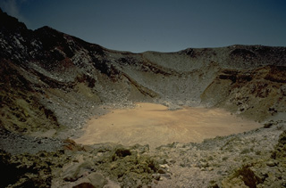 The summit of 1703-m-high Egon volcano in eastern Flores Island, seen here in 1971, contains a 350-m-wide, 200-m deep crater that sometimes contains a crater lake. Little historical activity has been reported from Egon; the most recent was a possible explosive eruption in 1907.
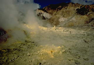 Steam rises from sulfur-encrusted fumaroles in the crater of Egon volcano on Flores Island in 1971.
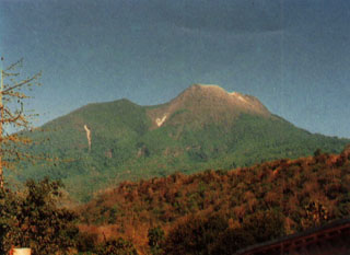 Gunung Egon, seen here from the NW, is located in eastern Flores Island. The lower flanks extend nearly to both the Flores Sea on the N and the Savu Sea to the S. The unvegetated summit of the volcano contains a 350-m-wide crater and there is a lava dome to the S.
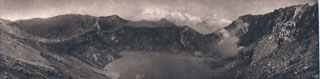 The crater of Gunung Egon contains a shallow lake in this 1920's view from the E. Fumarole plumes rise from the shores of the lake, which occupies the 350-m-wide, 200-m-deep crater.
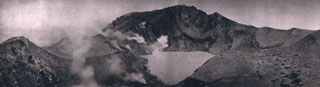 Fumaroles line the walls of the summit crater of Egon. A lake occupies the floor of the crater in this 1920's view from the southern crater rim. The northern crater rim marks the summit of the volcano.
 The high point on the rim of the active summit crater of Egon is visible at center, with an older crater rim and possible lava dome at left and in the foreground. The northern coast of Flores Island is visible in the gap, just left of another older ridge in the summit area at right.
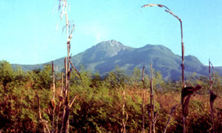 A lava dome (center) occupies the summit of Egon volcano. It is located in a narrow stretch of eastern Flores Island and its lower flanks extend nearly to both the Flores Sea to the N and the Savu Sea to the S. The unvegetated summit has a 350-m-wide, 200-m-deep crater that sometimes contains a lake. Other small crater lakes occur on the flanks.
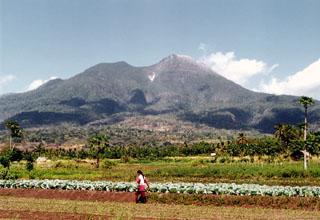 Egon volcano, with its vegetation-free summit lava dome, rises above farmlands at its base. The summit has a 350-m-wide, 200-m-deep crater that sometimes contains a lake. Other small crater lakes occur on the flanks of the volcano.
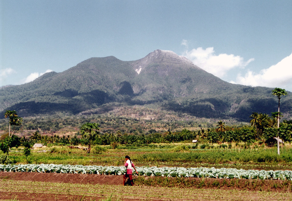
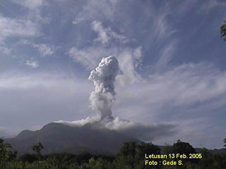 A plume rises above Egon volcano on 13 February 2005. Explosive eruptions on 6-7 February 2005 ejected ash and lapilli. On 14 February another explosion ejected ash and incandescent material to about 50 m above the summit. According to a news report, as of 17 February recent eruptive activity at Egon had prompted the local government to evacuate hundreds of residents living near the volcano. Minor ash plumes were reported during 25-27 February.
The maps shown below have been scanned from the GVP map archives and include the volcano on this page. Clicking on the small images will load the full 300 dpi map. Very small-scale maps (such as world maps) are not included. The maps database originated over 30 years ago, but was only recently updated and connected to our main database. We welcome users to tell us if they see incorrect information or other problems with the maps; please use the Contact GVP link at the bottom of the page to send us email.
There are no samples for Egon in the Smithsonian's NMNH Department of Mineral Sciences Rock and Ore collection.
| Copernicus Browser | The Copernicus Browser replaced the Sentinel Hub Playground browser in 2023, to provide access to Earth observation archives from the Copernicus Data Space Ecosystem, the main distribution platform for data from the EU Copernicus missions. |
| MIROVA | Middle InfraRed Observation of Volcanic Activity (MIROVA) is a near real time volcanic hot-spot detection system based on the analysis of MODIS (Moderate Resolution Imaging Spectroradiometer) data. In particular, MIROVA uses the Middle InfraRed Radiation (MIR), measured over target volcanoes, in order to detect, locate and measure the heat radiation sourced from volcanic activity. |
| MODVOLC Thermal Alerts | Using infrared satellite Moderate Resolution Imaging Spectroradiometer (MODIS) data, scientists at the Hawai'i Institute of Geophysics and Planetology, University of Hawai'i, developed an automated system called MODVOLC to map thermal hot-spots in near real time. For each MODIS image, the algorithm automatically scans each 1 km pixel within it to check for high-temperature hot-spots. When one is found the date, time, location, and intensity are recorded. MODIS looks at every square km of the Earth every 48 hours, once during the day and once during the night, and the presence of two MODIS sensors in space allows at least four hot-spot observations every two days. Each day updated global maps are compiled to display the locations of all hot spots detected in the previous 24 hours. There is a drop-down list with volcano names which allow users to 'zoom-in' and examine the distribution of hot-spots at a variety of spatial scales. |
|
WOVOdat
Single Volcano View Temporal Evolution of Unrest Side by Side Volcanoes |
WOVOdat is a database of volcanic unrest; instrumentally and visually recorded changes in seismicity, ground deformation, gas emission, and other parameters from their normal baselines. It is sponsored by the World Organization of Volcano Observatories (WOVO) and presently hosted at the Earth Observatory of Singapore.
GVMID Data on Volcano Monitoring Infrastructure The Global Volcano Monitoring Infrastructure Database GVMID, is aimed at documenting and improving capabilities of volcano monitoring from the ground and space. GVMID should provide a snapshot and baseline view of the techniques and instrumentation that are in place at various volcanoes, which can be use by volcano observatories as reference to setup new monitoring system or improving networks at a specific volcano. These data will allow identification of what monitoring gaps exist, which can be then targeted by remote sensing infrastructure and future instrument deployments. |
| Volcanic Hazard Maps | The IAVCEI Commission on Volcanic Hazards and Risk has a Volcanic Hazard Maps database designed to serve as a resource for hazard mappers (or other interested parties) to explore how common issues in hazard map development have been addressed at different volcanoes, in different countries, for different hazards, and for different intended audiences. In addition to the comprehensive, searchable Volcanic Hazard Maps Database, this website contains information about diversity of volcanic hazard maps, illustrated using examples from the database. This site is for educational purposes related to volcanic hazard maps. Hazard maps found on this website should not be used for emergency purposes. For the most recent, official hazard map for a particular volcano, please seek out the proper institutional authorities on the matter. |
| IRIS seismic stations/networks | Incorporated Research Institutions for Seismology (IRIS) Data Services map showing the location of seismic stations from all available networks (permanent or temporary) within a radius of 0.18° (about 20 km at mid-latitudes) from the given location of Egon. Users can customize a variety of filters and options in the left panel. Note that if there are no stations are known the map will default to show the entire world with a "No data matched request" error notice. |
| UNAVCO GPS/GNSS stations | Geodetic Data Services map from UNAVCO showing the location of GPS/GNSS stations from all available networks (permanent or temporary) within a radius of 20 km from the given location of Egon. Users can customize the data search based on station or network names, location, and time window. Requires Adobe Flash Player. |
| DECADE Data | The DECADE portal, still in the developmental stage, serves as an example of the proposed interoperability between The Smithsonian Institution's Global Volcanism Program, the Mapping Gas Emissions (MaGa) Database, and the EarthChem Geochemical Portal. The Deep Earth Carbon Degassing (DECADE) initiative seeks to use new and established technologies to determine accurate global fluxes of volcanic CO2 to the atmosphere, but installing CO2 monitoring networks on 20 of the world's 150 most actively degassing volcanoes. The group uses related laboratory-based studies (direct gas sampling and analysis, melt inclusions) to provide new data for direct degassing of deep earth carbon to the atmosphere. |
| Large Eruptions of Egon | Information about large Quaternary eruptions (VEI >= 4) is cataloged in the Large Magnitude Explosive Volcanic Eruptions (LaMEVE) database of the Volcano Global Risk Identification and Analysis Project (VOGRIPA). |
| EarthChem | EarthChem develops and maintains databases, software, and services that support the preservation, discovery, access and analysis of geochemical data, and facilitate their integration with the broad array of other available earth science parameters. EarthChem is operated by a joint team of disciplinary scientists, data scientists, data managers and information technology developers who are part of the NSF-funded data facility Integrated Earth Data Applications (IEDA). IEDA is a collaborative effort of EarthChem and the Marine Geoscience Data System (MGDS). |

