
INETER reported that the seismic station at the base of Cerro Negro recorded the onset of tremor at 0845 on 4 June. Seismicity fluctuated; Real-time Seismic Amplitude Measurement (RSAM) values increased to 60 units, from an average value of 14. From 1535 to 1731 the network recorded 49 earthquakes that were too small to be located.
Source: Instituto Nicaragüense de Estudios Territoriales (INETER)
Seismic swarm in 2013
Since our last report (BGVN 37:01), Instituto Nicaragüense de Estudios Territoriales (INETER) continued to conduct fieldwork at Cerro Negro during 2012-2013 and reported that stable conditions prevailed except for a small seismic swarm detected in 2013.
INETER reported that from Cerro Negro's activity during 2012 was considered normal. Several significant landslides occurred that year, particularly from the S-SW interior rim of the primary crater. Seismicity was variable throughout the year with some interruptions of the signal (table 5).
Table 5. Seismicity was reported in INETER monthly reports during January-June 2012. Note that representative values are presented in the RSAM column (not mathematical averages) whereas the Max RSAM column contains the highest value recorded each month. There was a station outage during part of January. Courtesy of INETER.
| Month | EQ Count | RSAM | Max RSAM | Tremor (hours/day) |
| Jan 2012 | 43 | ~20 | 160 | -- |
| Feb 2012 | 85 | ~20 | 80 | 3-18 |
| Mar 2012 | 76 | ~50 | 255 | 1-16 |
| Apr 2012 | 162 | ~20 | 50 | 1-15 |
| May 2012 | 111 | 12-30 | 65 | some |
| Jun 2012 | 179 | 10-20 | 45 | 1 |
A gas measurement campaign was conducted within Cerro Negro's main crater in collaboration with the Instituto Tecnologicos de Energias Renovables (ITER) in late 2012. During the course of fieldwork, on 26 and 30 November, and 1 December, the team measured diffuse CO2 emissions from the soil at 219 points. The preliminary results showed normal levels, ~33 tons per day, compared to past results from this area.
Temperature measurements for 2012 were reported based on the four different fumarolic sites within the main crater (figure 20). The range varied between 50 and 325 degrees C.
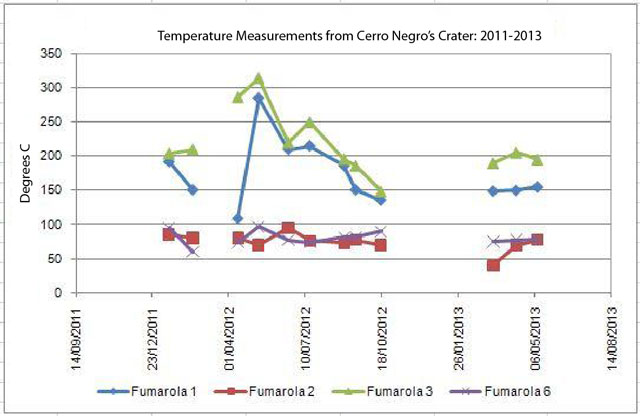 |
Figure 20. Temperature measurements from Cerro Negro's crater summarized for 2011-2013. Data were collected December 2011-May 2013. Four different fumaroles were sampled and measured (fumaroles 1, 2, 3, and 6; for locations see figure 21). The data were collected at intervals of days and many are shown here (as in the original INETER plot) connected with line segments. Courtesy of INETER. |
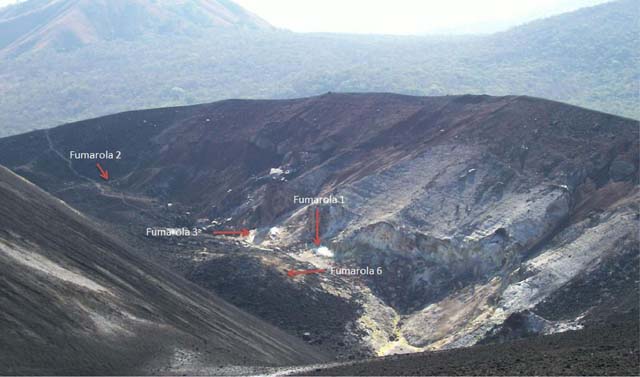 |
Figure 21. The location of the four measured fumaroles located within Cerro Negro's largest crater. The view is approximately to the N. Courtesy of INETER. |
Field investigations during March-June 2013 yielded additional observations of rockfalls and slides within the main crater. INETER also measured temperatures from the four fumarolic sites and concluded that steady conditions persisted (figure 20).
INETER reported a seismic swarm on 4 June 2013. RSAM had increased 60 units; 49 earthquakes were detected but were too small to be located. INETER maintained Alert Status Green and released informational statements to the media that described their response to the escalation and they also highlighted the potential of hazardous gas emissions for the area. The Sistema Nacional para Prevención, Mitigación y Atención de Desastres (SINAPRED) suggested that local residents and tourists in the area should be cautious around the flanks of Cerro Negro due to the possibility of rockfalls triggered by seismic events.
As a response to the increased seismicity that month, INETER conducted hot spring sampling and gas measuring campaigns in the area of Cerro Negro during 6-7 June. A team of fieldworkers focused on diffuse CO2 flux from the soil in a fault area on the W side of the Las Pilas-El Hoyo complex (SE of Cerro Negro, figure 15 in BGVN 37:01). The team took measurements 5 m apart at 91 points along a fault scarp, with depths of 11 and 40 cm within the soil; those measurements indicate an average flux of 59-80 ppm/s. No additional seismic unrest was reported during the month.
Information Contacts: Instituto Nicaragüense de Estudios Territoriales (INETER), Apartado Postal 2110, Managua, Nicaragua (URL: http://www.ineter.gob.ni/); Instituto Tecnológico y de Energías Renovables (ITER), 38611 Granadilla, Tenerife, Canary Islands, Spain (URL: http://www.iter.es/); Hoy: El Periodico que yo quiero, Managua, Nicaragua (URL: http://www.hoy.com.ni/2013/06/05/vigilan-al-volcán-cerro-negro/); and Sistema Nacional para Prevención, Mitigación y Atención de Desastres (SINAPRED), Managua, Nicaragua (URL: http://www.sinapred.gob.ni/).
2013: June
2004: January
2002: February
INETER reported that the seismic station at the base of Cerro Negro recorded the onset of tremor at 0845 on 4 June. Seismicity fluctuated; Real-time Seismic Amplitude Measurement (RSAM) values increased to 60 units, from an average value of 14. From 1535 to 1731 the network recorded 49 earthquakes that were too small to be located.
Source: Instituto Nicaragüense de Estudios Territoriales (INETER)
During 21-27 January, INETER continued to monitor seismicity at Cerro Negro. According to a news article, observers near the volcano reported ash clouds rising above the volcano, but scientists observing Cerro Negro on 19 January saw only gas emanating from cracks and fumaroles, casting doubt on the ash-cloud observations.
Source: La Prensa (Nicaragua)
According to INETER, an unusually large amount of seismic tremor occurred at Cerro Negro from December 2003 to at least mid January. The tremor had variable intensity, but was too small to be felt by the population near the volcano. During visits to Cerro Negro on 6 and 10 January, scientists did not observe any surficial changes or measure a temperature increase at fumaroles in comparison to previous months. INETER reported that the alert level may be increased from no alert to Green (the lowest alert level) if the amplitude of the tremor increases, or if there is an increase in other precursory activity.
Sources: La Prensa (Nicaragua); Instituto Nicaragüense de Estudios Territoriales (INETER)
A temporary increase in tremor and very small earthquakes occurred at Cerro Negro during 19 February at 2300 to 20 February at 1100. During a visit to the volcano on the 20th, INETER and Civil Defense personnel noted no important changes in activity in comparison to their previous visit on 16 February. They found a small 80- to100-m-long and 45-m-wide landslide, a new fumarole, fumarole temperatures that were slightly higher than normal, and a large amount of sulfur deposited on many fumaroles. According to INETER, the increase in tremor was possibly due to a temporary increase in volcanic gas emission related to the formation of the new fumarole. They stated that the population near Cerro Negro was not in direct danger, although people should be aware of the possibility of unexpected events.
Sources: La Prensa (Nicaragua); La Prensa (Nicaragua); Instituto Nicaragüense de Estudios Territoriales (INETER)
Reports are organized chronologically and indexed below by Month/Year (Publication Volume:Number), and include a one-line summary. Click on the index link or scroll down to read the reports.
Eruption in late October with frequent large ash explosions
Card 0172 (28 October 1968) Ashfall causes evacuations from 13 villages; lava flows from three craters
"Managua, Nicaragua, October 27, 1968. Thirty-five families were evacuated today as ashes rained on 13 villages around the erupting Cerro Negro (Black Ridge) volcano. Lava pouring from three craters crept forward at a rate of [23 m] a day. The Red Cross warned 10,000 villagers to prepare for evacuation as the volcano hurled rocks and ashes [4.8 km] into the air."
Card 0173 (28 October 1968) Large amount of 'smoke' and rock emissions from main cone
"Tremendous amount of 'smoke' and rock coming out of main cone. Flames coming out of smaller cone. Very little settlement in area and not too much danger to life and property."
Card 0175 (28 October 1968) Frequent explosions; ash falling in León and blowing S
"New 'smoke' coming out of east side. Explosions are occurring and one explosion follows another. We are about 10 km from the volcano and we have lots of ash falling on us right now. There is a big black belching 'smoke' cloud occurring at the present time and the wind is blowing it to the south."
Card 0176 (28 October 1968) New crater ejecting blocks and ash
"There is now 'smoke', ash, and pyroclastics coming from the volcano. One hundred meters south of the main cone there is a new crater which is 15-20 m in diameter and is ejecting blocks that are as much as 40 cm across. Rocks, ashes, and 'smoke' are coming out and activity has increased."
Card 0177-0178 (28 October 1968) Timeline of first 15 hours of activity during 24-25 October
24 October 1968. 1700: Peasants report activity on the hill, mistaking it for fires on the hillsides. 1800: First report given out by national radio. 1930: Eruption observable from the city of León as a reddish glow in the direction of the hill. 2030: The undersigned, accompanied by several persons, moved to the outskirts of the city in order to observe the eruption in more detail. 2100: The eruption, up to now in periods separated by short intervals and predominantly forming high clouds, becomes more continuous, nearly constant. Observing from the León-San Isidro Highway (approximately the 112th km), and with the aid of binoculars, one could make out what appeared to be the flight of incandescent rocks reaching quite considerable altitudes. 2400: Constant eruption of incandescent material apparently issuing from two eruptive mouths. Observable from the city as a great lighted torch
25 October 1968. 0750: Eruption continues. Observing from the city, one can see great black columns issuing more or less intermittently, at rather regular intervals, from the crater of the volcano. In the vicinity of the hill, one can observe the displacement toward the south of the eruptive clouds, coincident with some sort of selective separation of same, the lighter-colored clouds (probably ash) occupying a position more to the north, the darker ones (probably sand) remaining closer to the hill. On the slopes and in the neighborhood of the volcano, one sees cloudy zones as if it were raining; these are probably due to the precipitation of the sand.
Card 0183 (29 October 1968) Activity continued throughout the night of 28-29 October
"Volcanic activity continued throughout night of 28-29 October. Observation flight over volcano reports three open vents. Quite a lot of activity with explosions and belching 'smoke', ash, and ejecta continue on 29 October."
Card 0184 (29 October 1968) Ashfall in Managua; plume blown by winds over Pacific
29 October 1968. "The Cerro Negro volcano was spewing volcanic rock and ash [1,500 m] into the air Monday, but no damage or casualties were reported. Volcanic ash was being carried into the Pacific Ocean by strong winds and was also raining on this city, covering roofs of houses and cars, roads and trees. Agriculture officials feared the wind would change and bring hot cinders down on plantations of cotton, which is expected to start budding within two weeks. Nicaragua depends heavily on cotton."
Card 0195-0197 (30 October 1968) Ground and aerial observations since 24 October
Description of eruption by Richard Dillard, transmitted from the foot of the volcano at 2200 GMT on 29 October 1968.
"When it first started, there was very little of anything coming out of the top. The activity started with the two new craters opening up. I have flown over the volcano many times this year and in past years, and there were no craters there. It was just sealed. Just a few days before the eruption began, I noticed a little vapor coming out of the top and that is all but now there is a big crater on top and these two small ones down at the base. The two new craters at the base of the volcano burst out there on the first day. The new craters I would say are between [22 and 30 m] in diameter. They aren't too big, and they are sitting side-by-side; they are almost as one crater. From these two new ones there is a lava flow, and I would say that it is [135] or maybe [180 m] long, and it is flowing toward the west-maybe southwest going downhill. It is covering up all the trees and everything that is in front of it. It hasn't been going but a few days, but I would guess that it is moving somewhere around [27-37 m] a day. I would estimate that the width of the lava flow is about [90 m]. However, it seems to me that it is a little wider now than it has been. It seems to be getting a little wider each day. It is real hard to estimate the thickness of the lava flow, but I would say that it has built up to [~30 m] thick at the craters and probably not over [15 m] thick in the jungle.
"I have flown over the volcano every day, except one day, since it started erupting. On the first day there was very little coming out of the top crater-just a little ash-but very little.
"Lava is shooting up out of the craters as high as [15 m] and possibly higher. Right now, the lava is shooting up and continues to shoot up to a height of possibly [30 m] above the craters. The lava is flowing out of the craters and covering up the trees and setting the trees on fire. There is no doubt that during the past three or four days the activity has increased. I can see fire and lava that shoots up out of the top crater. During the past two days, the ash has been a continuous thing. I noticed today that the 'smoke' and ash had stopped momentarily, but then it came back again and really came back with a bang. The ash went straight up into the air at a real terrific speed.
"This morning I flew over the volcano at a height of [210 or 245 m]. I would say that the eruption cloud was at a height of [~1,200 m], but this could vary by [150 or 180 m]. The cloud is now higher. The wind up at that altitude is bringing the cloud more or less in the general direction of us here in León, and it has been raining black sand here along with a few showers of rain. This black sand has covered up everything, but I can see the ash fall going out as far as the Pacific Ocean."
Card 0199-0201 (31 October 1968) Detailed radio report of current conditions; heavy ashfall
Radio report from Richard Dillard from the volcano at 2230 GMT on 30 October 1968.
"We had thunderstorms here and did not hear this but went across the range of volcanoes this morning to the other side to work and the boys over there told me that sometime between 8 and 10 last night there were 4 or 5 real loud explosions and fire and lava shot up into the air and lit up that side of the mountain, and also it shook the ground-they felt the earth tremor all the time. They estimated the strongest time there that this lava and fire went possibly as high as [240-300 m] above the top of it.
"This morning at approximately 0700 there was another explosion but no earth tremor then. At 0827 exactly I did hear this one, and I was on the other side of the mountain [~24 km] N and they heard it here in León quite loud also.
"Now all day long this flow of ash and sand-black sand-the wind has been carrying it directly over León here and has covered everything up. It really has rained down today-a rain of black sand. Now from 11:35 to 11:45 I flew around this volcano just watching it, and it is quite a bit stronger today than it has been. The rocks and lava are shooting out of the top of it out of the main crater there to as high as [90 or 120 m] now. It is going way up in the air. I climbed up just to see how high the highest would reach and they are coming way up the lava itself and then when it comes out, it doesn't fall back in the crater as it has been. It is shooting out and is falling to the outside and this lava cools off and turns black before it gets to the side of the volcano there. That's how high it is pushing up today and this in between these which seem to be three one right behind another with continuous boom, boom, boom you know right up and then it just will hesitate for maybe a minute to two minutes sometimes—never goes over two minutes—and then here comes three more in and really strong today.
"There are definitely two craters-you might say side-to-side. There are only a few feet between them for a possibly 50, and the lava is flowing of course down the hill in our direction here in León which is to the west. The flow has increased because I would say today that lava is down the slope there almost [800 m] and from a minimum of [90 m] wide to [180] maybe [230 m] at the widest point and then back down at the very front of it to just about [90 m] wide, and it is at least [30 m] thick at the thickest places. I got real low to check the depth of it and in places it is a lot deeper than the trees are high on the edge of it, and I know those trees do get as high as [30 m] or more in that area. So it is at least [30 m], and I would say down on the edges about [15 m] thick.
"It is flowing quite a bit because all in the front and the side there's a flow now there is some 'smoke.' You can tell it is moving and burning a little. There is some 'smoke' coming up from burning these trees and it's a lot more-now I don't know just how much more than yesterday, but I did check some landmarks today, and we will be able to tell tomorrow how far the lava has moved within a 24-hour period."
Card 0202 (31 October 1968) Explosive events; lava flows and ash emission
The following was received from Richard Dillard, 30 October 1968. "Volcanic activity increased intensity with five explosive events occcurring between 0200 and 0400 GMT and two large explosive events occurring at 1300 and 1427 GMT. Over-flight between 1735 and 1745 GMT indicates lava and rocks shooting out of top crater to [90-120 m]. Lava flow now 1,000 m in length 250 m wide and 30-40 m thick. Black sandy ash fall continues over León."
Card 0203 (31 October 1968) Overflight shows minimal damage to cotton and other crops
The following was received . . . 31 October 1968. "Cerro Negro . . . began major eruption over weekend. Eruption . . . characterized by huge column black 'smoke,' light ash fall over wide area, emission of rock, flame, and lava from two or more crater vents. Ambassador and U.S. Aid Director flew over Cerro Negro area today to inspect volcano damage. So far it appears only minimal damage to cotton and other crops has occurred. Ashfall not yet of such dimensions as to constitute a problem."
Card 0206-0209 (30 October 1968) Timeline of activity during 25-28 October
The following is from Gladys León Quan on 30 October 1968.
25 October 1968. 1300: Eruption continues. 1700: After traveling for some three hours at an average velocity of 30 kms per hour, we arrived at the foothills of the volcano where we were able to observe at scarcely 5 m the burned rock hurled forth by the volcano, much of it still red and incandescent, and which on coming in contact with the vegetation was causing it to catch fire. The burned rock apparently accumulates on one side of the volcano producing small collapses from time to time and for this reason it was necessary to make our way across the hill toward its west side whence we were able to observe at quite a short distance the continuous explosions and eruptions of incandescent rock to a considerable altitude. The rocks thrown out were of every size and the explosions were constant although there were lapses in which the material emitted by the cerro was in greater proportion and greater size. Observing from nearby, one notes that there are two mouths operating on the cerro apparently continuously but one of these, the one lower down, emits material of larger size. Over a rather large radius the vegetation appears substantially covered with very fine particles, apparently a mixture of sand, mud or earth, and ash.
26 October 1968. 0945: Eruption continues. Sand is now beginning to fall in the city.
27 October 1968. 0600: Traveling toward the volcano over the León-San Isidro Highway, the volcano is perfectly visible throwing out thick columns of a very dark color, these being expelled with greater force than before and more continuously. Columns are observed proceeding from the apex of the cone of the cerro itself.
0800: At the foot of the volcano, one can observe the two mouths of the cerro in activity, the principal mouth hurling tall columns of sand accompanied by rocks of every size, which from time to time are thrown higher than they are now and fall on the slope of the volcano rolling down it to the foot. The rocks fall on one side of the volcano only. On the SE side, and nearly at the bottom of the slope, one sees the second crater, which unlike the other is not expelling sand, but rather a molten, incandescent material of a color between yellow-orange and red. The portions of this material are extremely varied in size between small particles and great masses perfectly visible. The sandy nature of the eruption of the principal cone was confirmed by collecting the sand which was falling, producing a noise as of rain as it fell among the trees - more separated trees arrayed about the foot of the volcano.
0845: We circle part-way around the foot of the volcano and arrive at the extremity of the incandescent volcanic rock issuing from the second crater which forms about some 5 kms approximately in length from the crater to the extremity of the advance and whose width I was not able to determine. The progressive advance of the burned rock which on its surface in contact with the air shows a dark coffee color with dark red tonalities. The advance takes place by the progressive breaking down and collapse of the rocks higher up and further forward in the extremity of the advance. These rocks on falling leave uncovered those further down which are of a live red color burning the trees and undergrowth which they encounter in the passage.
0945: We circle around the tongue of burned rock and manage to situate ourselves on a small hill rather close to the secondary crater. One can observe the hurling out of the live and constant red incandescent magma a great part of which falls back upon the crater itself. The eruption of magma is accompanied by noisy explosions which nevertheless produce no movements of the earth. Apparently there is a synchronization between the stronger eruptions of the principal cone and those of the secondary cone. Seen from the hill mentioned above, one can see that the material which the second crater is hurling out has a consistency of moldable dough which apparently turns hard almost immediately.
28 October 1968. The whole city awoke this morning covered with a considerable mantle of very fine sand. 1800: The second cone is seen from the city with a strong eruption of red material. The principal cone only from time to time emits some kind of reddish dust.
Information Contacts:
Card 0172 (28 October 1968) Reuters (through The Washington Post).
Card 0173 (28 October 1968) Edward Corin, Director of AID, American Embassy, Nicaragua.
Card 0175 (28 October 1968) L.E. Murphy, León, Nicaragua.
Card 0176 (28 October 1968) Mrs. McDonald, National Geographical Institute, Managua, Nicaragua.
Card 0177-0178 (28 October 1968) Gladys León Quant, National University of Nicaragua.
Card 0183 (29 October 1968) L.E. Murphy, León, Nicaragua.
Card 0184 (29 October 1968) Reuters.
Card 0195-0197 (30 October 1968) Richard Dillard, León, Nicaragua.
Card 0199-0201 (31 October 1968) Richard Dillard, León, Nicaragua.
Card 0202 (31 October 1968) Richard Dillard, León, Nicaragua.
Card 0203 (31 October 1968) American Embassy, Managua, Nicaragua.
Card 0206-0209 (30 October 1968) Gladys León Quant, Universidad Nacional Autonoma de Nicaragua, León, Nicaragua.
Explosions and lava flows continue from multiple vents
Card 0205 (04 November 1968) News report from Managua on 27 October
The following report (in Spanish) appeared in the "Novedades" (New Developments) in Managua, Nicaragua, 27 October 1968. Malpaisillo, October 26. At 2330 a rain of incandescent rocks and sulfurous gas columns was emitted from the Cerro Negro volcano, while a dense ash layer falls on this locality and many kilometers around. A third crater, almost next to the second, forcefully ejected gases and a small lava flow.
Card 0215-0216 (04 November 1968) Decreased ash emissions; lava flow divides
The following report was received from Richard Dillard of León, Nicaragua via radio on 4 November 1968. "Saturday (2 November) Between 4 and 5 o'clock there were four tremors. During the night last night (3 November), there were two or three. In the early morning hours today there were quite a few tremors, one right after another, but not too strong. They caused water to spout [from] the ground. There were not any sharp explosions from the volcano but some rumblings just like distant thunder. The wind is blowing ash directly over León. There is no sun shining. The ash has covered up the sky and, boy, it has covered everything up. . . . At the two new vents at Cerro Negro, the flow has divided and it is going in two different directions now, kind of like a 'Y.' There seems to be more fire and more lava but less ash and less 'smoke.'"
Card 0217-0219 (05 November 1968) Brief review of eruptive activity
The following was received from Louis Goldsmith, 5 November 1968.
"A new vent, at the base of Cerro Negro erupted at 0700 23 October 1968. This vent, located west of the old crater, spewed forth lava, which on 29 October had formed a flow 750 m in length and approximately 400 m wide, having an average height of 3 m and is moving at a rate of 0.75-1 m per hour. On 30 October this flow was approximately 600 m wide, and it appeared that the volume of lava issuing from this vent had increased.
"The original vent on top of the cinder cone, erupted on the morning of 26 October, sending coarse basaltic ashes 0.5 to 2 mm in size WSW over León, a distance of 20 km. Ash fall amounted to 0.5-1 cm in thickness in León. This fall ceased after several hours of duration. The eruption of the old vent sent 'smoke' clouds several hundred meters into the air, composed chiefly of very fine ash which is being carried out over the Pacific Ocean.
"The eruption from the old vent is sporadic in nature, with approximately 2-3 explosions per minute, sending black smoke accompanied by incandescent gases and molten rocks, several hundred meters skyward. The majority of this material falls back into the crater, with some boulders and basaltic ash falling onto, or in the immediate vicinity of, the cinder cone. At a distance of 0.5 km ash ranged up to 3 mm in diameter. The greatest observed distance from the crater, of ash fall at present does not exceed 5 km. Although some ash, not exceeding 2 cm in thickness on the ground, has fallen in fields in the immediate vicinity of Cerro Negro, no crop damage has resulted, due to the coarse nature of the ash. Nightly rains have washed this material from plants.
"The new lava vent at the base of Cerro Negro contains a lava fountain shooting molten lava to a height of 30 m into the air. The majority of this material falls back into the pool. The eruption is relatively quiet, with noise issuing rhythmically from the lava fountain. Occasional louder explosions are heard from the old vent, during those eruptions which send columns of black 'smoke' and rock skyward. Some gray 'smoke,' assumed to contain very fine ash, issues almost continuously from this vent as well. Periods of quiescence occur at very infrequent intervals, lasting no more than 2 to 3 minutes, when all 'smoke' ceases issuing from this vent.
"The lava flow is extremely gaseous, forming a highly vesicular lava, which upon cooling on the surface of the flow, is broken into fragments by the continuing movement within the flow. The incandescent gases issuing from both vents appear to rise to a height of [90-120 m] and can be readily seen at night from a distance of 50 km."
Card 0220 (07 November 1968) Explosions increase in frequency and strength
The following was received from the Science Attache at the American Embassy in Managua, Nicaragua, 7 November 1968. "Eruptive activity from Cerro Negro volcano and new lava vent in immediate vicinity continues to increase substantially both in frequency of eruption and in apparent force. There is increased volume of 'smoke,' ash, and lava being ejected, accompanied by violent, irregular explosions at a frequency of as much as four times per minute. These explosions throw glowing bombs, blocks, cinders, and ashes vertically to a height estimated at [180-210 m]. Extent and range of ash fall have increased materially with particles as great as 0.5 mm occurring to a distance of 30 km or more to the WSW of the Cerro Negro, and finer ash falling in areas as distant at 60 km."
Card 0221 (08 November 1968) New vent near summit is very active
The following information was received from Richard Dillard, León, Nicaragua, 7 November 1968. "The volcanic activity seems quite a bit stronger this morning. The two craters at the bottom are blowing quite a bit more lava there, and it seems to be stronger at the top. There's a new opening at the top about [6 or 9 m] down from the big crater. It opened up on the side, and it gives a continuous light-colored ash and 'smoke' pouring out of it—no batches of lava yet—just 'smoke' and ash. That's on the south side about [6 or 9 m] down from the top. The two lower ones (vents) seem to be quite a bit stronger. They are pouring this lava quite a bit higher today than it has been. The lava flow seems to be a lot thicker up closer to the two openings. The fire activity got stronger during the night."
Card 0234 (15 November 1968) Eruptions gradually increasing in intensity
The following was received [on] 15 November 1968. "Cerro Negro eruptions gradually increasing in intensity with particularly heavy 'smoke' and ashfall having begun 13 November. Ashfall is causing additional damage to croplands as ash accumulates."
Card 0235 (18 November 1968) Eruption cloud rising to 7,500 feet above sea level
The following report from William Melson and Robert A. Citron in León, Nicaragua, was radioed to the center by Richard Dillard via Virgil Bowers on 15 November 1968 at 1810 GMT. "Eruption cloud rises to [~2,300 m] above sea level. Small lower crater cone continues to emit aa-lava flow, incandescent ash and block emission from Cerro Negro crater. Lower crater emitting basaltic matter. Lava and ejecta contained some inclusions of partially melted solid plutonic rock. Ash continues to fall on León and points even farther west reaching the Pacific Ocean."
Card 0236 (18 November 1968) Continuous activity at the vents; lava fountaining
The following from Robert A. Citron in León, Nicaragua, was radioed to the Center by Richard Dillard via Virgil Bowers on 16 November 1968 at 1630 GMT. "One front of lava flow is advancing 15 cm per hour. The height of this front varies between 6 and 10 m. Both vents continuous activity; lava fountaining to a height of 70 m in new vent."
Card 0238-0239 (20 November 1968) Update on crop damage and evacuation
The following was received from Ambassador Kennedy M. Crockett of the American Embassy, in Managua, Nicaragua, 19 November 1968. "Cerro Negro eruption continues with gradual but marked increase in intensity. Aid mission director Coy and I made extensive tour of area 16-17 November. Executive Secretary of the National Cotton Commission maintains that damage has thus far been minimal, and area affected is less than twenty thousand acres. Several thousand acres of crop lands in the immediate vicinity of Cerro Negro have been severely damaged and some acreage has been rendered unusable for years to come. Fifty-eight families have been evacuated and Caritas is distributing PL 480 foodstuffs to an additional two thousand persons who have thus far been able to stay on, but whose garden crops have been completely destroyed. Plantings very near Cerro Negro are damaged, but cotton stands appear normal in size, color and foliage. However, at distances of over [48 km] from Cerro Negro, we found few bolls on the top [30-38 cm] of cotton plants examined and all developing bolls sampled were found to be heavily permeated with volcanic sand. Local growers maintain these bolls wither and drop off following exposure to a day or two of bright sunshine."
Card 0240-0242 (20 November 1968) Activity continues; sketch map
The following from Louis Goldsmith was received through the American Embassy in Managua, Nicaragua, 20 November 1968.
"A new vent at the base of Cerro Negro (figure 1) erupted at 0700 23 October 1968. This vent, located west of the old crater, spewed forth lava, which on 29 October had formed a flow 750 m in length and approximately 400 m wide, having an average height of 3 m and moving at a rate of 0.75-1 m per hour. On October 30 this flow was approximately 600 m wide, and it appeared that the volume of lava issuing from this vent had increased.
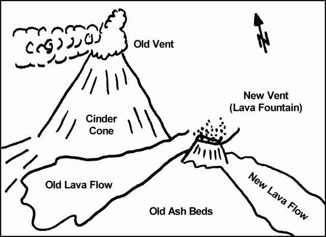 |
Figure 1. Sketch of Cerro Negro showing relative locations of the cinder cone and old vent, old ash beds, an old lava flow, and the new vent with a new lava flow issuing from it, late October 1968. Courtesy of Louis Goldsmith. |
"The original vent on top of the cinder cone erupted on the morning of 26 October, sending coarse basaltic ashes 0.5 to 2 mm in size WSW over León, a distance of 20 km. Ash fall amounted to 0.5 to 1 cm in thickness in León. This fall ceased after several hours of duration. The eruption of the old vent sent smoke clouds several hundred meters into the air, composed chiefly of very fine ash which is being carried out over the Pacific Ocean.
"The eruption from the old vent is sporadic in nature, with approximately 2-3 explosions per minute, sending black 'smoke' accompanied by incandescent gases and molten rocks, several hundred meters skyward. The majority of this material falls back into the crater, with some boulders and basaltic ash falling onto, or in the immediate vicinity of, the cinder cone. At a distance of 0.5 km, ash ranged up to 3 mm in diameter. The greatest observed distance from the crater of ash fall at present does not exceed 5 km. Although some ash, not exceeding 2 cm in thickness on the ground, has fallen in fields in the immediate vicinity of Cerro Negro, no crop damage has resulted, due to the coarse nature of the ash. Nightly rains have washed this material from plants.
"The new lava vent at the base of Cerro Negro contains a lava fountain shooting molten lava to a height of 30 m into the air. The majority of his material falls back into the pool. The eruption is relatively quiet, with noise issuing rhythmically from the lava fountain. Occasional louder explosions are heard from the old vent, during those eruptions which send columns of black 'smoke' and rock skyward. Some gray 'smoke,' assumed to contain very fine ash, issues almost continuously from this vent as well. Periods of quiescence occur at very infrequent intervals, lasting no more than 2-3 minutes, when all 'smoke' ceases issuing from this vent.
"The lava flow is extremely gaseous, forming a highly vesicular lava, which upon cooling on the surface of the flow, is broken into fragments by the continuing movement within the flow. The incandescent gases issuing from both vents appear to rise to a height of [90-120 m] and can be readily seen from a [distance] of 50 km."
Card 0243-0245 (20 November 1968) Observations while driving on local roads
The following report by Charles B. Johnson of AID was received from the American Embassy in Managua, Nicaragua, 20 November 1968.
"Visit to the city of León and Cerro Negro Volcano, 5 November 1968.
"León is a perfect study in gray - fine ash is everywhere. As we left León, and headed towards Chinandega, on either side of the highway, the cotton in the immediate area of León was heavily covered with ash, giving the plant leaves a shriveled-up appearance. This condition diminished considerably as we approached the Telica cut-off.
"At km 121.5 on the Telica / San Isidro Highway, we turned in towards Cerro Negro which provides an excellent view of the volcano. We stopped [~5 km] from the volcano and viewed the eruption with field glasses. On the León side of the Cerro Negro, there was a steady stream of heavy black 'smoke' pouring from it. In addition to the steady 'smoke,' there were periodic bursts or jets sent up of dense black 'smoke.' At times, there would be as many as three bursts occurring one right after the other and the force was sufficient as to send the 'smoke' hundreds of feet in the air. In addition to the great jets of black smoke, rocks were ejected with each explosion. Some were of such size as to be seen with the naked eye, although we were [~5 km] from the volcano. With field glasses, one could see considerable amounts of smaller rocks being ejected, many of which fell on the outer surface of the volcano.
"We proceeded to the town of 'Rota,' which although closer to Cerro Negro than León, is less affected than León due to the wind direction. We proceeded south-westerly on a rough dirt road that seems to run more or less [2.4-3.2 km] from the base of the volcano. We were soon in the area of heavy fall-out with a steady rain of ash approximately 0.5 mm. In taking what turned out to be a wrong turn, we ended up in the yard of a small farmer. The cotton on the road to his farm which is [~3.2 km] from the volcano, but directly in the path of the fall-out area, had been completely destroyed by the ash fall-out. The plant stems had broken under the weight of the ash. Mr. Cuevas, the farm owner, said he had moved the animals out of the area and pointed out the obvious fact that his cotton crop was ruined. He said that the area devoted to cotton was approximately 50 manzanas, of which 20% had been financed by the bank and the balance, as he put it, by his own sweat. He, as well as the few farm workers there, were covered with ash and a small boy on the roof of the little shack was trying to sweep off the [~13 mm] or more of accumulated ash. Mr. Cuevas stated that volcanic activity had increased considerably in the last two days.
"At a distance of [~1.6 km] from Cuevas' farm, we encountered crews with sticks of sufficient length to cover 3-4 rows of cotton, walking through the field with one boy at each end of the stick, knocking the ash off the cotton. The area already worked in this fashion did look much better.
"We finally approached within [800 m] of the new vent. All the while, ash continued to rain down on the area. This coarse ash, in short order, became very disturbing since it got into one's eyes, ears, clothing, shoes and equipment. The vent was belching lava to a height of some [60-90 m]. We approached within [2 m] of the hot lava flow which is coming solely from this new vent. As the solid crust of lava crumbled, one could see that the core of the lava bed is glowing red.
"On the return, and still in the area of heavy fall-out, we ran into a rain shower and the resulting droplets were large globs of ash. The windshield wipers of the jeep were unable to remove the heavy wet ash concentration. The cattle being driven from the area and the people were completely covered by this wet ash fall-out. On returning to León, the fields that had been covered with ash in the morning had been washed clean by an extremely heavy rainfall and the general appearance of the cotton was good, with no apparent damage. León, too, looked much better, although the streets were still covered with fine volcanic ash."
Card 0246-0247 (20 November 1968) Description of 2 November activity
The following by Louis H. Goldsmith was received from the American Embassy in Managua, Nicaragua, 20 November 1968.
"The erupting volcano Cerro Negro was again visited by the writer on 2 November 1968. At this time eruptive activity appears to have increased to a considerable extent in frequency of eruptions (or explosions) and in apparent force as compared to former visits (29 and 30 October). Both day and night observations were made.
"It appears that the vent at the top of the cinder cone actually is a double vent. The vent located westerly produces almost continuous gray brown 'smoke.' This almost continuous 'smoke' ceases for very brief time intervals. The easterly vent on the other hand produces violent irregular explosions, which may be as frequent as four times per minute. These explosions throw glowing bombs, blocks, cinders, and ashes vertically to a height estimated at [180-210 m]. These explosions viewed at night appear as fiery columns. The majority of the material falls back into the vent with a small percentage splashing onto the top of the cone, making a fiery display. Small rivulets of lava can be seen trickling short distances down the sides of the cone as the ejected material falls at the rim of the vent.
"Activity of the new lava vent also has increased somewhat. Molten globs and droplets of lava are sprayed to a height of [60 m]. A very bright glow is noticeable at night for a great distance. The rim of this vent has built up to a height of [15 m] about the original opening due to splashings of lava. The entire volcanic activity is marked by viscous lava of high gas content.
"Ash content and range of ashfall appears to have increased materially. Almost continuous ashfall, of particles as coarse as 0.5 mm, occurs at a distance of 30 km or more from Cerro Negro. Finer size ash has been noted 60 km from the volcano. Ash distribution varies considerably with wind shift but is chiefly in a WSW direction, at/or in the vicinity of León. No visible crop damage of any extent has been noted, or reported to date."
Card 0256-0257 (27 November 1968) Highlights of activity during 30 October-20 November
The following was received from Gladys León Quant of the National University of Nicaragua, 27 November 1968.
30 October 1968. 1900: The cone of the volcano is throwing up small quantities of red lava (which it hasn't done before) almost every 5-8 minutes. The main cone is also forming a greater number of darker clouds and these are rising higher than before.
3 November 1968. 1900: The new volcano named Christo Rey is increasing its activity. The amount of lava being thrown up by the Cerro Negro cone and the height to which it is thrown have both increased since 30 October. This activity stops from time to time, but not for more than 15 seconds. On 1 and 2 November the falling of small quantities of sand in León ceased. (Sand fell in Corinto and Malpaisillo, north of León.) However, sand began falling again in León on 3 November.
8 November 1968. 1900-2030: The Cerro Negro is constantly throwing up red lava to a height of 300-400 m. This activity ceases occasionally for 2-3 seconds, but at times, it covers almost the whole cone with red lava stones. Activity at the Christo Rey cone is increasing, and the cone is now quite high. (Before the eruption, the Christo Rey location was an almost imperceptible hill at the foot of Cerro Negro.)
15 November 1968. 2000-2200: The activity of the Cerro Negro has increased during the week. It is now producing very large, dark (almost black) clouds of sand constantly. This sand is falling mainly in León and the villages of Rota and Lechecuagos. The red stones being thrown up by Cerro Negro are forming a higher and wider column that is almost constant. The Christo Rey cone is throwing up red stones higher and higher, and the cone itself is at least 2 m higher than one week ago.
19 November 1968. The sand rain is increasing in León.
20 November 1968. 0800: The black clouds coming out of Cerro Negro are increasing in size.
Card 0258 (29 November 1968) Ash eruptions and lava flows continuing
The following cable was received from the American Embassy in Managua, Nicaragua on 25 November 1968. "Cerro Negro volcanic eruption and lava flow are continuing with somewhat heavier emissions of rock and ash than previously, beginning on November 23-24. Ashfall has occurred principally due west of volcano toward León, but occasional shifts in wind also carrying ash to other areas northwest and southwest of volcano."
Information Contacts:
Card 0205 (04 November 1968) Novedades, Managua, Nicaragua.
Card 0215-0216 (04 November 1968) Richard Dillard, León, Nicaragua.
Card 0217-0219 (05 November 1968) Louis Goldsmith, Managua, Nicaragua.
Card 0220 (07 November 1968) Science Attache, American Embassy, Managua, Nicaragua.
Card 0221 (08 November 1968) Richard Dillard, León, Nicaragua.
Card 0234 (15 November 1968) Science Attache, American Embassy, Managua, Nicaragua.
Card 0235 (18 November 1968) William Melson and Robert A. Citron, SI.
Card 0236 (18 November 1968) Robert A. Citron, SI.
Card 0238-0239 (20 November 1968) Ambassador Kennedy M. Crockett, American Embassy, Managua, Nicaragua.
Card 0240-0242 (20 November 1968) Louis Goldsmith; American Embassy, Managua, Nicaragua.
Card 0243-0245 (20 November 1968) Charles B. Johnson, AID; American Embassy, Managua, Nicaragua.
Card 0246-0247 (20 November 1968) Louis H. Goldsmith, Principal Geologist, Ralph Parsons Company; American Embassy, Managua, Nicaragua.
Card 0256-0257 (27 November 1968) Gladys León Quant, National University of Nicaragua.
Card 0258 (29 November 1968) American Embassy, Managua, Nicaragua.
Activity decreases in early December
Card 0263-0264 (02 December 1968) Description of 28 November activity
The following was received from Louis H. Goldsmith, 2 December 1968.
"Cerro Negro was again visited on 28 November 1968. The intensity of activity appears to have increased to some extent, being marked chiefly by a vast increase in output of ashes, lapilli, and bombs, which are being distributed over a wider area. Ash production is presently so great as to occasionally obliterate the view of Cerro Negro. Bombs and lapilli are being distributed over a considerably larger area, and are being thrown a distance of 2-3 km from the cinder cone.
"The new lava flow issuing from the vent at the base of Cerro Negro, as well as old lava flows, are almost completely covered by airborne material, making it possible to readily walk upon them. The vent of Cerro Negro has enlarged greatly, flattening and slightly lowering the top of the cone. The force of the explosions from this vent is sending large blocks and glowing coarse material to a height estimated at [600 m]. Explosions are almost continuous and the volume of noise has increased.
"No other changes have been noted, with the exception that ashfall underneath the 'smoke' cloud is almost continuous for a distance in excess of 30 km, with coarse particles being carried farther than previously noted. This increase in the force of activity appears very striking as compared to observations undertaken in the past."
Card 0275 (07 December 1968) Eruption diminished sharply; no ash cloud
The following was received from the American Embassy in Managua, Nicaragua, on 7 December 1968. "Cerro Negro eruption diminished sharply during course of last 24 hours, reportedly ceasing altogether by last night. Immense cloud of volcanic sand and ash which has characterized eruption throughout its forty days of activity has disappeared, to intense relief of León inhabitants and farmers in area westward from volcano. Attention now turning to clean-up of heavy accumulation of sand and ash in León, and to salvaging of cotton and other crop production on farms in Cerro Negro area."
Card 0278 (10 December 1968) Observations from highway on 28 November and 2 December
The following was received from Gladys León Quant on 9 December 1968. "As of 2 December, lava was still coming out of the two volcanoes. Although a thick curtain of falling sand prevents the volcanoes from being observed from León, they are readily visible from the Managua-León Highway (km 70). From this location on 28 November, I was able to see that the red lava columns were three times higher than they were on 1 November. Also the red lava columns are no longer constant. They now show short periods of inactivity followed by great bursts which form high columns."
Card 0279 (10 December 1968) Intermittent activity during the night of 9-10 December
The following was received via radio from L.E. Murphy, 10 December 1968. "Cerro Negro volcanic activity stopped all night, but it has been coming back for periods of maybe 20 minutes or half an hour, and it will stay off for a couple of hours at a time. It has been off since last night, and it hasn't started up today at all. There is still a little bit of lava coming out of the vents, but no 'smoke.'"
Information Contacts:
Card 0263-0264 (02 December 1968) Louis H. Goldsmith, Managua, Nicaragua.
Card 0275 (07 December 1968) American Embassy, Managua, Nicaragua.
Card 0278 (10 December 1968) Gladys León Quant, National University of Nicaragua, León, Nicaragua.
Card 0279 (10 December 1968) L.E. Murphy, León, Nicaragua.
Mild gas and ash explosions in December 1969
Card 0851 (19 January 1970) Mild gas and ash explosions in December
"A series of mild gas and ash explosions occurred at Cerro Negro over a 10-day period from about 19 December to the 29th as reported by American crop-dusting pilots in León. I witnessed such explosions from a moderate distance on 27 and 28 December. The explosions lasted only a minute or so but blew a small ash cloud [~600 m] high. The crater has been somewhat enlarged since a year ago and many additional blocks blown out in the current period. During the middle of the 10-day period, four or five explosions occurred per day. On the 28th, there were two explosions, but only one on the 29th."
Information Contacts: W.H. Parsons, Wayne State University.
Strong eruption from a new vent causes ashfall over a very large area
Eruptions on 3-4 February send ash to an altitude of 20,000 feet
J. Sides, while on a flight between Managua and San Pedro on 4 February, observed the volcano emitting ash up to an altitude of [~6.1 km]. "The Cerro Negro volcano . . . began erupting suddenly on 3 February 1971. Reports say that the volcano "belches flashes of fire and thunder from the crater" while sending ash [~6.1 km] into the air. Parts of northwest Nicaragua and sections of Honduras are covered with a heavy layer of black ash. The city of León has [~18 cm] of ash on the ground. A Swedish ship, the "Brasil," located [32 km] off the coast of Nicaragua, reported "a rain of ashes falling."
Card 1126 (11 February 1971) New vent producing lava and tephra; ashfall 80 km away
Telephone Report received from Gladys Quant in León, Nicaragua at 0700 GMT on 11 February 1971. "Cerro Negro volcano began a hard eruption at 1000 local time on 3 February. It is a much stronger eruption than in 1968 (November-December) and it is even worse than the eruption of 1947. A new vent opened up (not the 1947 vent or the 1968 vent) and it is producing a lot of lava, sand, and ashes. The eruption is visible from León, 20 km to the west. The ash column was reported to a height of 10,000 m (unconfirmed) and the ashes are falling at least 80 km from the volcano and out to sea. We measured a depth of 1.5 cm of sand in León on 8 February, the fifth day of activity. The eruption activity diminished somewhat last night (February 9th local time) but started up again early this morning (February 10th local time). This is a much different kind of eruption than the 1968 eruption."
Card 1128 (16 February 1971) Ashfall covers an area of 300 square kilometers
The following was received by telephone on 14 February 1971. "The Cerro Negro volcano began a very strong eruption on 3 February 1971 after 14 months of quiescence. Very strong and nearly constant activity continued for 7 days (until 9 February). The eruption was characterized by the production of a tremendous volume of ash which now covers an area of 300 km2, in some places to a depth of 10 cm. Much of the ash has fallen in a northwesterly direction from the volcano and out over the Pacific Ocean. The activity is limited to the central vent whose eruption cloud reached a height of 7,000 m on 3 February. The cloud produced continuous electric flashes of light that were particularly spectacular at night. There has been no lava flow to date. At the present time, the eruption has diminished somewhat with a sporadic cycle: low activity for ten minutes; no activity for fifteen minutes; resurgence of low activity, etc. No lava flow is expected."
Card 1138 (26 February 1971) Description on early eruptive activity
The report describes the early eruption activity. "Eruptions were of basaltic pyroclastic material, bombs, lapilli and ash. Bombs and gases incandescent to [600 m] above crater. Cloud reached [6.1 km] with strong constant lightning between cloud and summit of crater. No lava flow observed. Ash fallout in center of cloud in town of León, 1 mm/hour and at edge of cloud 4 km SW of crater, 500 grams/hour/m2. Ash was carried SW by winds for unknown distance into ocean."
Information Contacts:
Card 1118 (08 February 1971) Joseph Sides, National Science Foundation, USA; Jose Viramonte, National Geological Service, Managua, Nicaragua.
Card 1126 (11 February 1971) Gladys León Quant, National University of Nicaragua, León, Nicaragua.
Card 1128 (16 February 1971) Jose Viramonte, National Geological Service, Managua, Nicaragua.
Card 1138 (26 February 1971) Jose Viramonte, National Geological Service, Managua, Nicaragua.
Fumaroles generate small white plume
A small white plume formed by several small fumaroles was visible from the air in early February 1980.
Information Contacts: R. Stoiber, S. Williams, and M. Bruzga, Dartmouth College.
New fumarolic area on Cerro La Mula
When geologists visited Cerro Negro in June, fumaroles on the N side of the crater reached 320°C. A new, low-temperature, fumarolic area had formed 1 km N of Cerro Negro on the E flank of Cerro La Mula. A linear zone of recently-killed vegetation extended 200 m along a NNW trend. Cerro Negro last erupted in February 1971, ejecting about 4.5 x 10⁶ m3 of tephra.
Information Contacts: R. Stoiber, S. Williams, Dartmouth College; M. Carr and J. Walker, Rutgers Univ.; A. Creusot, Instituto Nicaraguense de Energía.
Small vapor plume; seismicity drops
In late 1980, summit crater fumaroles remained at temperatures as high as 300°C. A small vapor plume was intermittently visible. Seismic activity had dropped from the high level of June.
Information Contacts: R. Stoiber, S. Williams, H.R. Naslund, L. Malinconico, and M. Conrad, Dartmouth College; A. Aburto Q. and D. Fajardo B., Instituto de Investigaciones Sísmicas.
Minor fumarolic activity
"A flight over the crater in mid-March revealed 1 area of minor fumarolic activity in the SW center region of the crater. No significant seismicity has occurred recently.
Information Contacts: S. Williams, R. Stoiber, Dartmouth College; D. de Jerez, IRENA; D. Fajardo B., Instituto de Investigaciones Sísmicas.
Small fumarolic region
"A small region of fumarolic activity was observed high on the W wall of the crater in late November."
Information Contacts: R. Stoiber, S. Williams, H.R. Naslund, J.B. Gemmell, and D. Sussman, Dartmouth College; D. Fajardo B., Instituto de Investigaciones Sísmicas.
Small gas plume from crater fumaroles
"A very small gas plume was being emitted from a group of fumaroles on the NW inner crater wall. Maximum fumarole temperatures of 505°C were measured on 3 March."
Information Contacts: S. Williams and R. Stoiber, Dartmouth College; I. Menyailov and V. Shapar, IVP, Kamchatka; D. Fajardo B., INETER.
Minor fumarolic activity
Minor fumarolic activity continued. The maximum temperature was 320°C and has not varied since 1980.
Information Contacts: D. Fajardo B., INETER; R. Parnell, Jr., Dartmouth College.
Gas column; fumarole hotter than in mid-1982
A small column of gases was observed in March, but there was no seismic activity. A fumarole temperature of 337°C was measured, 17° higher than in mid-1982.
Information Contacts: D. Fajardo B., INETER.
Fieldwork reveals few changes since 1985-86; fumarole temperatures
When visited on 16 January, little change was noted from 1985-86. Some fumaroles have stopped emitting gases, but other new ones have formed. Vegetation has begun to appear on the crater's eastern rock buttress. When measured by infrared radiometer from 1-5 m distance, the temperatures of 10 fumaroles generally ranged from 100-200°C, with a maximum of 228°. Averaging over larger areas yielded temperatures of 100°C+ (100 m2) and 60°C+ (1,000 m2). Other temperature data are shown beside figure 2. Cerro Negro has been the site of frequent activity since 1850, most recently in 1971 when explosive activity from the summit and E flank fed 6-km clouds.
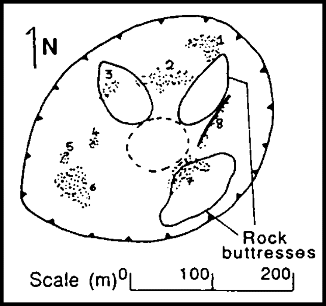 |
Figure 2. Sketch map of Cerro Negro's crater on 16 January 1988. Temperature measurements (of points labeled on the map) from about 200 m distance: (2-7) 40-50°C (10 m2 resolution, total ± 2,000 m2); (8) 50°C+ (25 m2). Temperatures were taken with an infrared radiometer measuring surface brightness temperature in the 8-14 µm range with emissivity set at 1. |
Information Contacts: B. van Wyk de Vries, H. Rymer, and G. Brown, Open Univ; P. Hradecky and H. Taleno, INETER.
New fumaroles in recent slump area S of the crater
On 10 March, gas temperatures of up to 255°C were measured at fumaroles on the inner wall of the crater, 15-20 m below the N rim, with Minolta Cyclops 33 (bandpass 8-14 µm, 1° field of view) and Cyclops 52 (bandpass 0.8-1.1 µm, 0.33° field of view) infrared thermometers. Temperatures are not corrected for emissivity and atmospheric absorption effects. Since January 1988, a number of concentric slumps have developed S of the crater. New fumaroles with temperatures to 80°C have appeared along a fissure in the slump area.
Information Contacts: C. Oppenheimer and D. Rothery, Open Univ; B. van Vyk de Vries, O. Castellon, and L. Urbina, INETER.
Continued fumarolic activity
"The Cerro Negro fumaroles continue to have temperatures of <=250°C (December 1990)."
Information Contacts: B. van Wyk de Vries, O. Castellón, A. Murales, and V. Tenorio, INETER.
Strong Strombolian eruption with heavy ashfall and 28,000 evacuated
Violent Strombolian activity occurred at the volcano on 9-12 April, and resumed at lower intensity on 13-14 April. Heavy ashfall forced the evacuation of 28,000 people [but see BGVN 17:04] from nearby towns and from parts of León (18 km WSW; figure 3), the second-largest city in Nicaragua, between 10 and 12 April. No fatalities directly related to the eruption were reported, although there were two accidental deaths during the evacuation. The volcano was quiet as of 20 April.
 |
Figure 3. Map showing locations of Cerro Negro and neighboring volcanoes, with nearby cities and towns affected by the eruption. Contour interval, 200 m. Based on sheet ND16-15 (Managua), U.S. Defense Mapping Agency series 1501, Joint Operations Graphic (Ground). |
9-12 April 1992. No instrumental seismic data were available before the eruption, but 5 earthquakes were felt in villages within 5 km of the volcano at about 2300 on 9 April, signalling the onset of activity. The first explosion occurred at 2320, and was quickly followed by the eruption of incandescent material with the development of a large ash cloud. The initial eruption plume rose an estimated 4000 m above the cone, and contained material up to bomb-size.
The ash cloud was visible on weather-satellite images beginning at 0000 on 10 April, and by 0530, the cloud extended 300 km to the WSW (264° azimuth), with a maximum width of about 200 km, at an estimated initial altitude of 6 km. Both ground and satellite observations indicated that the eruption was vigorous and nearly continuous. The eruption column, clearly visible from Managua (60 km SE) much of the time, was estimated from the ground to be approximately 7 km high. Satellite images showed that the plume extended 400 km W on 11-12 April. Material ejected to about 7.5 km during more energetic pulses of the eruption was carried roughly 50 km NE by higher-altitude winds. SO2 plumes that are significantly below the tropopause (roughly 16 km at this latitude) are difficult to detect with NASA's Total Ozone Mapping Spectrometer, and none were evident during the Cerro Negro eruption.
Ash began falling in León within 1 hour of the onset of activity, and formed deposits up to 4 cm thick by 1700 the next day. Very fine ashfall was reported as far away as the Pacific Coast (50 km W, in Corinto). Late on 10 April, the wind direction changed from WSW to W and ash accumulations were recognized in Telica (16 km W). That evening, 15 houses and several other structures, including a few large storage buildings, collapsed in León and surrounding areas. Collapses of numerous farm buildings, rural homes, and school buildings were reported over the next several days.
Ashfall continued W of the volcano, with accumulations of 2.5 cm of ash in Telica, 1.5 cm in Quezalguaque (20 km W), and 0.1 cm in Chinandega (50 km WNW) by 12 April. A change in wind direction to the SW during the night of 11 April caused the first ashfall S of León. That evening, incandescent material was observed consistently rising 300 m above the crater. Activity continued the following day, but was intermittent and less vigorous, finally ceasing at about 1800 on 12 April. During the 9-12 April activity, the crater diameter increased from approximately 100 m to 300-400 m.
13-14 April 1992. Only very light fumarolic activity was observed in the crater, and the volcano was otherwise quiet until explosions reportedly resumed around 2200-2300 on 13 April. An infrared satellite image at 2300 showed an already developed eruption cloud, which extended to about 350 km SSW by 0700 on 14 April. Remnants of the ash cloud produced by the more violent 9-12 April eruption were still evident 500 km W of the volcano on satellite images at 0800. Strombolian activity on 13-14 April ejected bombs to about 300 m height and produced a light ash cloud about 3.5 km high, but the interval between explosions (5 seconds early on 14 April), and their intensity, decreased throughout the day. The maximum recorded rate of ashfall in León, 2.4 gm/m2/minute, was measured at 1000. Although the plume appeared to be disconnected from the volcano on a satellite image at 1200, ground observations indicated that the eruption continued at lesser intensity until about 1730. Only light fumarolic activity was observed the following day.
Deposit thicknesses were 1 m, 1.2 km W; 15 cm, 13 km WSW; 5 cm, 20 km WSW; and 1 cm, 39 km WSW of the volcano. Rough calculations based on preliminary isopach mapping by INETER suggest a total erupted volume of approximately 0.03 km3 DRE.
Seismicity. Seismic stations were installed around the volcano on 10-11 April. During 10-12 April, low-frequency, low-amplitude seismic tremor was nearly continuous. Some B-type earthquakes were also recorded. The tremor rate declined on 12 April and tremor ceased on 13 April.
Several A-type events were recorded in the hours before the renewed eruption on 13 April. Tremor accompanied the eruption, and ceased at the end of explosive activity. Seismic data collected on 13-15 April (figure 4) show a very rapid rate of increase in seismic energy release immediately prior to the resumption of the eruption on the 13th, nearly steady-state energy release for the duration of the eruption, and a very rapid decrease to background levels following cessation of activity on the evening of the 14th. Geologists suggest that these data support the existence of a relatively open conduit that rapidly delivers magma from depth, and the current lack of any voluminous magma body close to the surface. On 17 April, 40 earthquakes were recorded near the volcano, a significant increase from seismicity on 15-16 April.
 |
Figure 4. Real-time Seismic Amplitude Measurements (RSAM) at Cerro Negro, 13-15 April 1992. Courtesy of C. Connor. |
Information Contacts: Claudio Gutiérrez (Director); Helman Taleno L., Fabio Segura M., Martha Navarro C., Oscar Urbina L., and Wilfried Strauch, INETER, Aptdo. 2110, Managua, Nicaragua; Patricio Jerez, IRENA, Kilómetro 12, Carretera Norte, Managua, Nicaragua; C.B. Connor, FIU, Miami; J. Lynch, Thomas Baldwin, and Charles Kadin, SAB; S. Doiron, NASA GSFC; Deborah Jerez, 9808 Natick Rd., Burke, VA 22015 USA.
Details of April tephra deposits and seismicity; changes to cone; feeder dike exposed
Ending 21 years of quiet, violent Strombolian explosions began at about 2320 on 9 April, shortly after 5 felt earthquakes (BGVN 17:03). The initial explosive phase produced a plume 7-7.5 km high, and deposited ash to the W and WSW (figure 5), before ceasing at about 1800 on 12 April. Between 6,000 and 9,000 people were evacuated (corrected from BGVN 17:03), and numerous houses and buildings collapsed under the weight of the accumulated ash. Reduced explosive activity (plumes to 3.5 km high) resumed at around 2200-2300 on 13 April, gradually decreasing until about 1730 on 14 April (figure 6), when all activity ceased.
 |
Figure 5. Preliminary isopach map of 9-14 April 1992 ashfall deposits from Cerro Negro. Prepared by INETER. |
 |
Figure 6. View of Cerro Negro's eruption from 4 km NW, 14 April 1992. Courtesy of G. Soto. |
Field observations, 13-14 April 1992. The volcano was visited by a team from the National Seismic Network (ICE-UCR) of Costa Rica, who operated two short-period portable seismometers on 13 and 14 April, 1 and 4 km from the crater. The following is from Gerardo Soto.
According to reports by residents near the volcano, the initial explosive activity on 9 April seemed to have been preceded by low-magnitude earthquakes. These occurred during the few minutes immediately preceding the explosion, and were only felt within 5 km of the volcano, neither causing damage nor alarming area residents. No seismic records exist for the period 9-12 April. During the 30 hours of seismic observations by the ICE-UCR team, periods of calm alternated with explosive activity. Observations can be summarized as follows: a) virtually no volcano-tectonic (A-type) seismicity was recorded; b) only a few small low-frequency events (durations <1 minute) and small tremor episodes were recorded during most of the quiet period before explosive activity resumed at 2200 on 13 April; c) a progressive increase in recorded tremor activity began at 2000 on 13 April, culminating in high-energy tremor completely saturating the record; d) continuous high-energy tremor was recorded during the roughly 19 hours of explosive activity that followed, with intermittent pulses of increased amplitude and energy (approximately 10 pulses/hour). Geologists interpreted the seismicity as indicating an open system, allowing the magma a direct and rapid ascent to the surface.
Tephra emitted during the eruption was carried predominantly W of the volcano, although very fine ash was reported at 13 km altitude over northern Nicaragua, probably carried by high-altitude winds from the Pacific Ocean. Two granulometric analyses were conducted: 1) ash collected on 13 April, 0.5 km NW of the crater, on Cerro La Mula; and 2) ash collected on 14 April, 21 km along the axis of dispersal, in León (table 1). The ejected ballistic tephra were abundant within 0.5 km of the crater, and less common to 1 km radius. Shrubs were severely damaged within this area. The ballistic clasts are gray-black porphyritic olivine basalts, with phenocrysts of plagioclase (about 30%), olivine (about 5%), and pyroxene (about 1%). Scoriae are black and strongly vesiculated, whereas the gray cognate blocks are poorly vesiculated. The fine ash deposited along the axis of dispersal was rich in millimeter-sized glassy scoria fragments, and isolated crystals of plagioclase and olivine.
Table 1. Granulometric analyses of April 1992 bulk airfall deposit samples from Cerro Negro, collected on 13 April 1992 at Cerro la Mula (0.5 km NW of the crater, and on 14 April at León (21 km SW of the crater). * indicates that the largest clast was smaller than 2.0 mm. Courtesy of ICE-UCR.
| Size (mm) | Cerro la Mula sample % | Cerro la Mula cumulative % | León sample % | León cumulative % |
| 16-8 | 9.9 | 9.9 | -- | -- |
| 8-4 | 22.8 | 32.7 | -- | -- |
| 4-2.38 | 26.5 | 59.2 | -- | -- |
| 2.38-1.19 | 27.9 | 87.1 | 1.2* | 1.2* |
| 1.19-0.6 | 9.1 | 96.2 | 4.5 | 5.7 |
| 0.6-0.3 | 2.5 | 98.7 | 48.8 | 54.5 |
| 0.3-0.15 | 0.9 | 99.6 | 36.4 | 90.9 |
| 0.15-0.075 | 0.5 | 100.1 | 4.5 | 95.4 |
| less than 0.075 | 0.0 | 100.1 | 4.5 | 99.9 |
During the first three days of the eruption, government officials reported severe damage from ashfall over an area of about 186 km2, of which about 116 km2 are corn, cotton, sesame, beans, and other grain cultivation, and 70 km2 are sugar cane. In addition, numerous cattle were affected. The most severe damage extended from the volcano to the city of León. Primary damage to home, commercial, and industrial infrastructure, estimated at $3,000,000, was mostly caused by roof collapse on the first day of the eruption. As of 15 April, there were no reports of injuries directly related to the eruption. The 50 indirectly related injuries occurred predominantly during evacuations, and from falls as people cleaned their roofs; 1-2 people died from falls. The primary medical complaints were eye and respiratory problems. Refugees were evacuated to 4 centers distant from the most affected area.
Field observations, 23-29 April. The following, from S. Williams, describes fieldwork during 23-29 April.
A rusty brown plume was emanating from the region close to Cerro Negro during the approach to Managua on 23 April. The plume reached 1-2 km, extending W to >100 km, causing the pilot to detour W, far out to sea, to avoid it. During a 1 1/2 hour visit later that day to a site about 3 km SW of the crater, there was no visible gas emission, noise, landslides, or felt seismicity, suggesting that the plume consisted entirely of re-suspended fine ash from the regional tephra blanket. COSPEC measurements from the same site the next day yielded a barely discernible SO2 signal; calculations suggested a maximum SO2 flux of <25 metric tons/day (t/d). Again, there were no visible signs of activity from the volcano.
On 28 April, the summit was clear for 40 minutes during a helicopter overflight. The crater appeared to be very quiet, with 3 main regions of low-pressure degassing, occupying essentially the same sites known from before the 1992 eruption. The crater was estimated to have widened somewhat, to at least 300 m in diameter (but had not tripled in width as indicated in BGVN 17:03), and was about 2x deeper than formerly. The inner-crater walls were extremely steep (about 60° in places) and cut outward-dipping tephra beds of the old cone. In the lower portion of the crater, a large dike was plainly visible. Concentrations of large boulders (>2 m in diameter) were scattered at the E base of the cone, apparently after being ejected beyond the crater rim during the eruption and rolling down the cone's outer slopes.
The distribution and impact of the ash blanket were visible when flying over León. The collapsed structures tended to be public (e.g. schools) or large businesses (e.g. cotton warehouses) and apparently represented the failure to clean accumulated scoriae and ash from their roofs. León was still the site of major cleanup efforts; most households removed all of their clay roof tiles, cleaned them and replaced them. There appeared to be only minor danger of mudflow activity, reflecting the low topographic relief of the area, the fact that no major drainage begins on Cerro Negro and continues through León, and the relatively thin deposits (about 3 cm in León). Selected drainages were to be cleaned out, for fear that even small mudflows might damage bridges on the Pan American highway.
The crater was visited on 29 April by a group of Nicaraguan, American, and Russian scientists. A fault circled virtually the entire crater rim, with vertical and horizontal offset of ~25 cm. The fault was the site of minor degassing and fumarole sublimate deposition; maximum gas temperature was 189°C. The very steep slopes and nearly complete fault suggested that the crater will undergo massive slumping, probably after the first rains soak the scoriae, and will resume its more typical broad, shallow, bowl-like form. The rim was notably more uneven than the pre-1992 rim, reflecting heavy accumulation of scoriae on the W margin; the low point on the rim was about 675 m, and the high point might have reached 850 m. No agglutinate was found anywhere in the crater or on the rim.
A descent was made to the principal accessible fumarole field, adjacent to the dike on the SW side of the crater. The dike was oriented at 290° and extended intermittently across the crater, becoming more pipe-like (~6 m in diameter) at the center, where it appeared to represent the primary eruptive conduit. All of the remaining degassing occurred along the dike, centered on a small zone about 10 m long on its SE portion, at the central pipe, and on its NW portion. The maximum measured temperature was 350° and abundant sublimate deposition was evident (possibly thenardite). Degassing was quite diffuse and passive, and the overall appearance was remarkably like that seen in a previous visit in 1982. There was a strong smell of HCl, with notable SO2 odor but no H2S.
Information Contacts: G.J. Soto and R. Barquero, ICE; Sergio Paniagua and Hector Flores, Sección de Sismología, Vulcanología y Exploración Geofísica, Escuela Centroamericana de Geología, Univ de Costa Rica, Apdo. 35 UCR, San José, Costa Rica; S. Williams, Arizona State Univ; Martha Navarro C. and Silvia Arguello G., INETER, Apdo. 2110, Managua, Nicaragua; Josephine Malilay, Health Studies Branch, F-28, Centers for Disease Control, 1600 Clifton Road, N.E., Atlanta, GA 30333 USA.
No fumarolic activity; vegetation recovers from 1992 eruption
"No sign of fumarolic activity was seen when the base of Cerro Negro was visited on 6 January. Predictions that the farming area between Cerro Negro and the city of León (18 km WSW), would be devastated by the ashfall of April 1992 (about 4 cm of ashfall) had fortunately not been fulfilled. Fields >2 km from the volcano were cultivated again after the April 1992 event and farmers were expecting good harvests. Wild vegetation appeared healthy and had regrown to original levels. A few large trees close to the volcano appeared to have died after the eruption."
Information Contacts: Andrea Borgia, Instituto Nazionale di Geofisica, via di Vigna Murata 605, 00143 Roma, Italy; B. van Wyk de Vries, Open Univ; Peter J. Baxter, Dept of Community Medicine, Fenner's, Gresham Road, Cambridge, England.
Fumarolic activity along crater rim
Fumaroles observed during several visits to Cerro Negro on 2-5 September were issuing from circumferential fractures along the N rim of the crater and from feeder dikes in the base of the crater. Fumaroles along the crater rim exhibited weak and variable degassing, with temperatures ranging from 79 to 90°C. Stronger fumaroles remained confined to the feeder dikes within the crater. No attempt was made to enter the crater because of steep and unstable slopes. Little evidence of mass slumping of unconsolidated material from the crater wall was observed.
Information Contacts: Michael Conway and Andrew Macfarlane, Florida International Univ; Charles Connor, Southwest Research Institute; Oscar Leonel Urbina and Cristian Lugo, Instituto Nicaraguense de Estudios Territoriales (INETER), Nicaragua.
Temperature data and Rn, CO2, Hg, and He anomalies
Beginning on 27 May, scientists from FIU and INETER spent 7 days at Cerro Negro as part of an ongoing project to determine the areal extent of passive degassing and the role of structural controls on degassing at the cone. During three field surveys, more than 65 stations were established over an 8 km2 area to determine the concentration of Rn, CO2, Hg, and He.
Two anomalies were discovered. The first fell along step-faults, fractures, and low-temperature (80-90°C) fumaroles on the N rim of Cerro Negro. The anomaly extended at least 1.5 km N into the Cerro La Mula cinder cone complex. Along the anomaly, Hg ranged from several hundred to >4,000 ppb; He ranged from 5,260 to 5,540 ppb; Rn ranged to 24 picoCurie/liter; and CO2 ranged to 3.1 volume %.
A second anomaly stretched from the ESE foot of the cone to about 1 km S to the Las Pilas-El Hoyo complex. Gas concentrations along this anomaly were somewhat less than those reported for the N-rim anomaly. The anomalies were collinear with an alignment of 12 cinder cones and maars, a progression of vents that includes Cerro Negro.
Ground temperatures measured in May along the N rim (70-90°C) and on the E flank of Cerro La Mula (45-65°C) were identical to temperatures measured in March. A low-temperature (75°C), low-flux fumarole was noticed for the first time, at the E base of Cerro La Mula, about 700 m N of Cerro Negro. This fumarole was probably ephemeral, it was apparently not fuming during the dry season.
Researchers further noted an apparent increase in flux from fumaroles on dike complexes in the crater of Cerro Negro. (Crater fumaroles at Telica behaved similarly in June, and nearby villagers reported that degassing always increases during the wet season). Compared to March, during May the concentrations of Rn and CO2 at Cerro Negro increased 2-6 fold. According to Wilfried Straunch and Helman Telano (Seismological and Volcanological section of INETER, respectively), seismicity at Cerro Negro remained at background levels. Thus, the recent increase in fumarole output and in gas concentrations appeared linked to the onset of the rainy season, and not to increased magmatic degassing.
Information Contacts: Michael Conway, Peter Lafemina, and Andrew Macfarlane, FIU; Christian Lugo, INETER.
Tremor increases after 7 September, but no steam or ash
After the last eruption of Cerro Negro in April 1992 (BGVN 17:03 and 17:04), telemetry-equipped seismic instruments donated by the Japanese government were installed in November 1993. During the previous 10 months, seismic behavior has chiefly consisted of low-amplitude high-frequency events, but beginning on 7 September this changed. Tremor amplitudes increased, first to 2 mm but later reaching 10-12 mm, and tremor episodes lasted from minutes to hours. Field observers inspecting the summit on 15 September found neither steam nor fresh ash. Tremor and high-frequency seismicity continued through 30 September. Other recent fieldwork has investigated the extent of passive degassing and the chemical composition of the emissions (BGVN 19:06).
Information Contacts: H. Taleno, L. Urbina, C. Lugo, and O. Canales, INETER.
Increased seismicity precedes explosive ash eruptions in late May-June
Seismicity recorded during 24-28 May at the CNGN station (~500 m E of the crater) consisted of tremor lasting from 30 minutes to several hours; dominant frequencies were 1-3 Hz. Additional microseismicity recorded there was not strong enough to be detected by instruments ~15-20 km away. Fumarolic activity through 28 May had changed little since the last phreatomagmatic eruption in April 1992.
In the late afternoon on 28 May, small ash-bearing explosions were observed by N-flank residents. A news report noted that the explosions caused some residents to leave their homes and seek shelter in the nearby city of Malpaisillo. Activity during 28-31 May consisted of ash plumes rising at least 100 m above the crater rim. Explosions during the days occurred once or twice per hour. Tremor was also recorded, including episodes lasting ~30 minutes. INETER reported the increase in activity to Nicaraguan Civil Defense on 25 May, and informed the mass media and population on 29 May.
On 30 May a group of French scientists visited the crater. During this time, seismicity measured at the foot of the cone remained very low. They noted that a new vent had formed in the bottom of the central crater (~120 m deep and ~250 m across). The vent, ~10-15 m in diameter and "some meters deep," was located on the W rim of the pipe that opened in 1992. All of the central crater fumaroles, located along dikes on the floor, were undisturbed, and emitted gases with a temperature of <=350°C. Weak degassing occurred between rhythmic explosive phases lasting 20-30 minutes. Observers on the crater rim during the night of 30 May saw incandescent material thrown 200 m high. Although there was no activity for >20 hours on 31 May, activity had resumed during a 1 June visit.
An early June aviation report noted sporadic columns of ash to 2-km altitude. Activity was continuing through late June; additional details will be provided in the next Bulletin.
Information Contacts: Wilfried Strauch, Instituto Nicaraguense de Estudios Territoriales (INETER), Division of Geophysics, Managua, Nicaragua; Alain Cruesot-Eon, French Embassy, Managua, Nicaragua; United Press International (UPI); International Civil Aviation Organization, Air Navigation Bureau, 1000 Sherbrooke Street West, Suite 400, Montreal, Quebec H3A 2R2, Canada.
Small lava flows in main crater; ash eruptions end in mid-August
Increased seismicity was detected at and up to 15 km around Cerro Negro during 24-28 May. Ash plumes to ~100 m above the crater rim were first observed on 29 May (or the afternoon of 28 May). The eruptions (1-2/hour) correlated with periods of increased seismic activity. On 1 June, the seismicity increased in frequency and intensity, with eruptions occurring about every 15 minutes. Fine-grained ash, consisting primarily of free crystals with minor amounts of basaltic fragments, was deposited N of the cone (figure 7). Bulk density of the ash deposit was measured at 1.3 +- 0.2 g/cm3. Trace amounts of ash (0.5 mm) from eruptions on 2-5 June fell as far N as Malpaisillo (figure 7), with 1-mm ash thicknesses extending 5 km N of the vent. This deposit represents 1 x 10⁴ m3 of ash, equivalent to an eruption rate of 100 m3/hour.
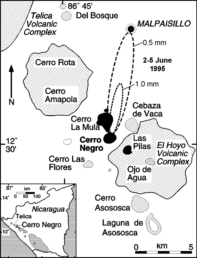 |
Figure 7. Location map of Cerro Negro and adjacent volcanoes, Nicaragua. Dashed ellipses show the interpreted extent of 0.5- and 1-mm-thick ash deposits for 2-5 June 1995 activity. Courtesy of Brittain Hill. |
Eruptive activity was observed and recorded during 2-5 June, 6 June-1 July, and 24 July-16 August. During this time, activity was characterized by discrete explosions occurring on average every 8 +- 5 minutes. There was no apparent periodicity to the explosions, although patterns of increasing and decreasing repose times were apparent. These explosions commonly produced convective columns at least 400 m above the cone, and sometimes rising ~1 km; many produced ballistically transported blocks. Most blocks fell within the crater, but some occasionally impacted as far as half way down the outer slope of the cone. Blocks that reached maximum heights (100 m) and distances had estimated ejection velocities of 100-120 m/second.
The most intense activity was observed just before noon on 2 June, when a small dilute pyroclastic flow formed on the NW flank of the cone during an explosion. Deposits from this flow were found on the NW flank and extended <100 m from the base. The massive, fine-grained (<1 mm median diameter), and very well sorted deposit was ~1 cm thick on the cone slope and covered very fine ash from 29 May-1 June explosions. Although this deposit has the high degree of sorting and grain-size characteristics of surges, sorting is better than commonly observed in basaltic surge deposits (Wohletz, 1983). One explanation for this high degree of sorting is that the deposit was produced from a dilute, relatively low energy surge, which lacks a magmatic component common in most other basaltic surge deposits (Wohletz and Sheridan, 1979). This interpretation is consistent with the generally phreatic character of the eruption.
Seismic activity increased markedly on 24 July, with sustained periods of nearly constant tremor. A small lava flow formed in the E part of the main crater on 24-25 July. Ash eruptions during and after the lava emission continued at the same apparent frequency and magnitude as before. A sporadic increase in seismicity on 3 August was accompanied by increased degassing from within the crater. However, there was no associated increase in the number or magnitude of ash eruptions. Eruptive activity decreased significantly on 15 August, and ceased on 16 August.
Soil radon concentrations were monitored at 28 stations deployed around the base of Cerro Negro during early June. These stations were located near a permanent seismic station on the SSE side of the volcano, and on and near the Cerro La Mula Ridge, which extends NW from Cerro Negro (figure 7). Anomalously high radon concentrations were observed at nearly all of these stations during 2-3 June. At one station (700 m SSE of the crater), the radon concentration was 396 pCi/L on 2-3 June and 146 pCi/L on 3-4 June, compared with 17 pCi/L previously measured (Conway and others, 1994). Anomalous values (100-1,000x background) also were observed on 2-3 June at stations located up to 800 m N of the crater. Radon concentrations had dropped to near background levels at most stations by 4-5 June, but eruptive activity continued with little change. We conclude that a pulse of soil degassing occurred during the initial stages of the eruption, likely associated with dike injection and fracturing of wallrock.
A self-potential anomaly across Cerro La Mula Ridge, 750 m N of the active crater, correlated with the location of low-temperature fumaroles (60-88°C), and radon anomalies. Temperature increases of ~30°C were measured in this area, associated with the 1995 eruptive activity. Continuous monitoring of the self-potential anomaly on 4-5 June revealed amplitude changes corresponding to diurnal changes in air and ground temperatures, and periods of rainfall.
Preliminary ash-leachate studies by M. Navarro show low total S and Cl, along with low S/Cl, consistent with lack of a juvenile component in the ejecta. In addition, the regularity of the eruptions, the consistent fine grain-size of the deposits, and lack of obvious juvenile components support the interpretation of activity as dominantly phreatic. The heat needed to drive this event was provided by the intrusion of a small volume of magma into the shallow subsurface. Evidence for the presence of new magma includes the eruption of lava on 24-25 July, observed patterns of seismicity, increased temperature and radon flux in thermal areas, and the relatively constant periodicity of eruptions over the days of direct observation.
Cerro Negro is the site of the most recent small-volume basaltic eruption at a cinder cone in the western hemisphere, having last erupted in April 1992 (Connor and others, 1993). Cerro Negro first erupted in 1850, with at least 19 documented eruptions occurring up to April 1992. The longest eruption occurred in 1960, when activity persisted for approximately three months. Cerro Negro is characterized by unusually explosive eruptions, and may represent the upper end of basaltic eruption explosivities. Preliminary research suggests that this explosivity may be controlled by relatively high magmatic water contents (>2 weight percent) associated with highly crystalline, viscous magmas (Roggensack and others, 1994).
References. Connor, C.B, Powell, L., Strauch, W., Navarro, M., Urbina, O., and Rose, W.I., 1993, The 1992 eruption of Cerro Negro, Nicaragua: An example of Plinian-style activity at a small basaltic cinder cone: EOS, Transactions of the American Geophysical Union v. 74, no. 43, p. 640.
Conway, F.M., Macfarlane, A.W., Connor, C.B., LaFemina, P.C., and Reimer, M., 1994, Degassing at a young cinder cone: Volcan Cerro Negro: Geological Society of America, 1994 Annual Meeting Abstracts with Program, 26 (7), p. A453.
Roggensack, K., Williams, S.N., Hervig, R.L., McKnight, S.B., Connor, C.B., and Navarro, M., 1994, Evidence of polybaric fractionation: Melt inclusions in 1992 eruption of Cerro Negro volcano, Nicaragua: EOS, Transactions of the American Geophysical Union, v. 75, no. 44, p. 747.
Wohletz, K.H., 1983, Mechanisms of hydrovolcanic pyroclast formation: grainþsize, scanning electron microscopy, and experimental studies: Journal of Volcanology and Geothermal Research, v. 17, p. 31-63.
Wohletz, K.H., and Sheridan, M.F., 1979, A model of pyroclastic surge: Geological Society of America Special Paper 180, Boulder, CO, p. 177-194.
Information Contacts: Martha Navarro, Oscar Canales, and Wilfried Strauch, Instituto Nicaraguense de Estudios Territorales, Managua, Nicaragua; Brittain E. Hill, Charles B. Connor, F. Michael Conway, and Peter LaFemina, Center for Nuclear Waste Regulatory Analyses, Southwest Research Institute, 6220 Culebra Rd., San Antonio, TX 78238-5166 USA.
Vigorous eruption produces a new cone, dome, lava flows, and large ash plumes
A significant eruption in November-December followed almost six months of unrest and minor eruptive activity. During a crater visit on 13 November no precursors were observed, and on 18 November only background seismicity was recorded by the CNGN station (500 m E of the crater).
Early phase of activity, 19-22 November. Local residents first noticed explosions about the time of the onset of 30 minutes of mildly increasing seismicity detected by the CNGN station at 1145 on 19 November. Following a pause, seismicity continued to gain strength. Increasing activity was reported that afternoon by residents in Malpaisillo (~10 km N). Observations on the night of 19-20 November indicated mild Strombolian activity, with vertically directed ejecta, that was gradually increasing in strength. A Notice to Airmen (NOTAM) was issued the next day warning aviators of the volcanic activity.
Eruption tremor amplitude increased continuously and saturated the CNGN station (60 dB gain) at 0200 on the 21st. Tremor was detected on short-period seismic stations within a 30 km radius (at San Cristóbal and Momotombo volcanoes, and near the city of León). Energy release increased continuously and tremor could be felt over 1 km away, when sitting down, as a smooth rocking motion.
At 2000 on 21 November incandescent bombs were being thrown up to 300-400 m above the 1992 crater rim. Ash content was low compared with the 1992 and May-August 1995 activity, and bombs were often very large (meters across), which deformed and broke up in flight. Because of near-vertical trajectories, few bombs fell outside the crater. The new cone being built within the 1992 crater (figure 8) had a steep (>45 degrees) basal scarp, 2-5 m high, followed by a level bench and then a less steep slope (25 degrees) to its crater. Ejecta pulses maintained a frequency of 20/minute, but the size and duration of each pulse varied. From 0255 to 0310 on 22 November ejecta heights were <150 m but ash content and degassing were much higher, emitting dark clouds with each explosion. A thick, white lower plume appeared to be escaping from a new lava dome in the 1992 crater, 50 m W of the new cone (figure 8). By 0500 the eruption had regained previous intensity levels and exhibited near-constant fire-fountain-like activity, bombs were larger, and pulse frequency increased to 22/minute. The eruption continued at this level for over 4 hours.
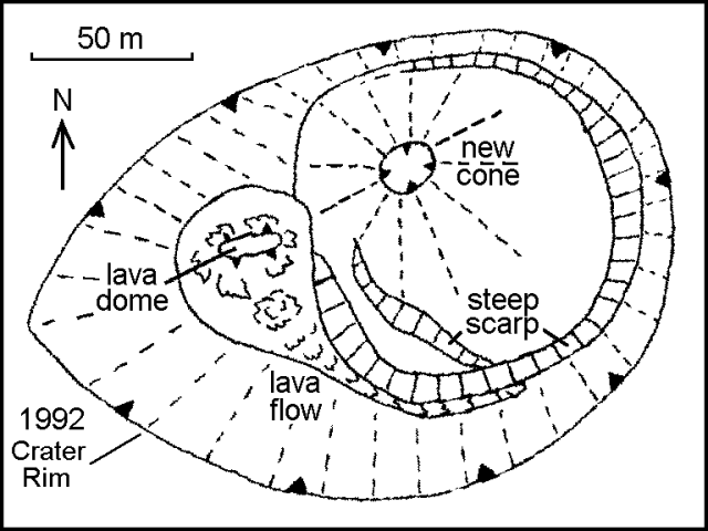 |
Figure 8. Sketch of the crater at Cerro Negro, 0700 on 22 November 1995. Drawn from photographs taken by Pedro Perez; courtesy of INETER. |
The new cone had almost reached the lip of the 1992 crater by 0700 on 22 November. At that time the lava dome emitted a small lava flow, 2-5 m wide and 50 m long, that followed the edge of the new cone towards the lowest part of the 1992 crater (figure 9). From 0930 to 1000 a series of explosions ejected material to the lower slopes of the new cone. Sand to gravel size ash fell W of the cone, but no large ejecta. Compared to the 1992 ejecta this material is highly vesicular with millimeter-size vesicles; olivine, pyroxene, and plagioclase are present, and some plagioclase crystals are 1 cm long. That evening the new cone overgrew the N rim of the 1992 crater and material began spilling towards Cerro La Mula. From 1900 to 2300 a tongue of lava spilled over the N rim of the 1992 crater. The front moved at less than 1 m/hour, but blocks constantly tumbled from the front down to the base of the main cone.
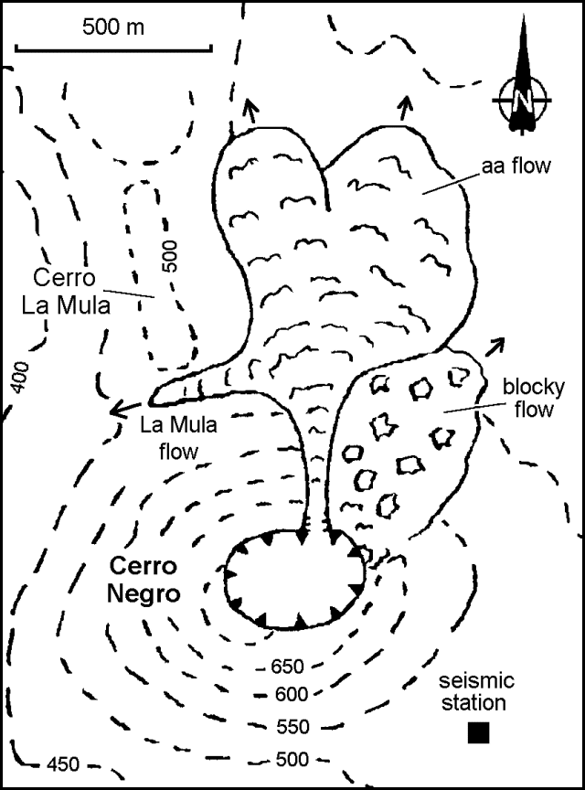 |
Figure 9. Sketch map of Cerro Negro showing active lava flows, 2000 on 23 November 1995. Drawn by B. Van Wyk de Vries; courtesy of INETER. |
Lava flows beyond the crater, 23 November. After 1400 on 23 November dark gray pulses observed from 25 km away formed a plume that rose faster and higher than on previous days, attaining several kilometers altitude. Observations were made from the seismic station after 1500. During about 1515-1525 the plume became less ash-rich, ejecta became less frequent, and strong degassing pulses were heard. When regular pulses resumed, some bombs were ejected laterally onto the flanks of the main cone. Periodic heavy falls of 1-3 cm scoria were encountered by the scientists walking under the plume 1.5 km from the cone. Red glow was visible at 1730 over Cerro La Mula, and there was a smell of burning vegetation, suggesting an active lava flow. The lava tongue was observed at 1800 between Cerro La Mula and Cerro Negro (figure 9). Later named the La Mula flow, it was ~20 m wide and 5 m thick, and advancing at ~2 m/hour.
At 1830 a 20-m-wide lava stream moved down the N flank through a small breach at a rate of ~150 m/minute from the crater rim to the base of the cone. A lava field spreading out from the base of the cone had reached ~1 km from the crater by 2000, advancing 10-30 m/hour along two 300-m-wide fronts (figure 9). To the E of the flow the volcano flank appeared to be bulging and was irregular with large blocks jutting out that occasionally fell downslope, revealing incandescent lava. It appeared to the scientists that a slow-moving 20-m-thick blocky lava flow was moving to the crater rim and collapsing down the flank; however, the shape of the flank also suggested outward bulging. The blocky lava extended at least 200 m NE from the base of the cone.
Continuous and voluminous pulses at 2000 created a fountain that sent bombs at least 600 m above the crater. Ash clouds accompanied each pulse and occasional flames of burning gas reached 100-200 m above the crater. This activity had decreased by 2045, and by 2115 pulses of bombs appeared only every 30 seconds, although continual noise suggested smaller pulses.
Of the four GPS stations set up in the vicinity of the cone, by 23 November one had been destroyed by lava and another was too dangerous to approach. Measurements at the remaining stations were within the error of the equipment (2 cm at best). However, two fresh fault scarps radial to the cone were observed on the W side with 5 cm of displacement. Tremor energy increased continuously until 1200 on 23 November, after which it maintained a constant level.
Continuing activity, 25-26 November.The eruption plume was again clearly visible on 25 November from Managua as a diffuse gray column turning horizontal at ~2,000 m. At 0900 distinct pulses of dark gray ash rose from the crater and formed mushroom shapes before drifting W and being incorporated into the plume; ashfall was reported in León and Corinto. At times only massive bombs were thrown out, while at others strong explosions sent up dense ash clouds. Ash and highly vesicular scoria
At 1100 on 25 November most bombs were still ejected vertically, but a significant number were exiting at low angles and falling low on the flanks. The new cone had grown to ~40 m across, and its top was ~30-50 m below the 1992 crater summit. Bombs fell mostly on the cone and rolled down to the base. The small breach where the 23 November lava flow exited was partly covered by a new blocky flow, which appeared to come straight N from the new cone, though no exit vent was visible. It may have been produced by accumulated, still liquid ejecta beginning to flow outwards, as seen on 22 November. The flow had advanced half way down the flank, covering another blocky flow. The dome in the crater had grown to ~100 m wide and 40 m high. Blocks were continually spalling off the dome, which also sustained a continuous rain of bombs from the new cone. Multiple small lava tongues originated from the dome. The crater dome was less pronounced on 26 November, and was blocky rather than spiny. The new cone had grown ~10 m overnight.
The two flows moving N on the 23rd had reached ~1-1.5 km from the volcano. The larger W lobe was ~400 m wide and 3-5 m thick at the front with a small lobe extending down the gully below Cerro La Mula, and another extending E into a depression in the old N lava field. The E lobe had extended into forest at the E side of the old N lava field. Over a three-hour period the flows advanced ~12 m. A low ash-covered area with a small old cinder cone separated the lobes. The sides of each flow were slowly (~1 m/hour) encroaching on this and thickening. The thick lava lobes below the dome were advancing, and many areas of the dome were glowing. The ~30-m-wide La Mula lava flow had advanced W ~500 m down a small valley and was moving at ~1 m/hour on 25 November; by 0600 on the 26th it had stopped. By 0645 the other lava fronts had advanced 20-50 m since the previous evening. The main W lobe had spread E and a large block in the middle of the flow had moved ~100 m.
Seismic tremor levels remained high through 26 November. Tremor was continuous and distinctly felt up to 1.5 km from the cone.
Satellite observations of the ash plume. Visible satellite imagery on 25 November indicated a possible low-level ash cloud at 1245 (figure 10). The height of the plume was estimated at 4,500 m altitude and was moving SW at ~30 km/hour. Another small low-level plume was seen on imagery at 0815 the next day at an estimated 2,750 m altitude and moving WSW at ~35 km/hour. Explosive activity increased on 1 December, when visible imagery at 1230 revealed a plume 18 km wide extending ~320 km W; it was estimated to be between 3,000 and 6,000 m altitude. By 0900 on 2 December, the plume extended at least 640 km W and was below 4,000 m.
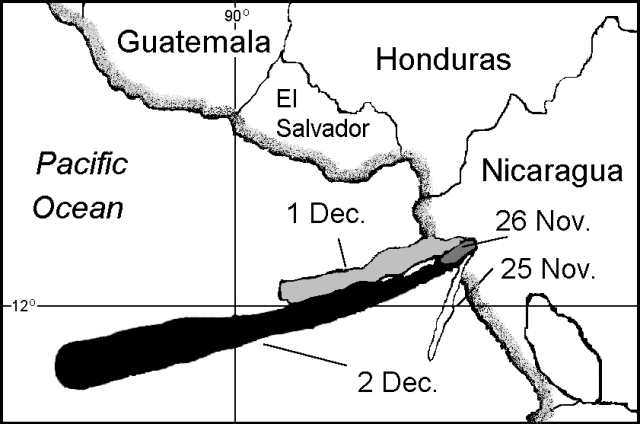 |
Figure 10. Map showing ash plumes from Cerro Negro detected on visible satellite imagery on 25-26 November, and 1-2 December 1995. Courtesy of the Synoptic Analysis Branch, NOAA/NESDIS. |
End of the eruption, early December. Explosive and effusive activity ended on 6 December. However, a lava flow was still moving N on 8 December. Isopach maps of the ashfall through 2 December (figure 11) were constructed by Markus Kesseler based on 85 GPS control points (precision +- 30 m). The 0.1 cm isopach encloses an area of ~200 km2. An estimated 12,000 people were affected by this eruption, about 6,000 of whom had been evacuated from 15 rural communities. Farmland was significantly damaged by ashfall and lava flows during the harvesting season; most of those affected were farmers and their families.
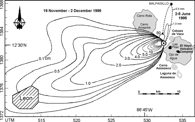 |
Figure 11. Isopach maps of ashfall from Cerro Negro, 19 November-2 December 1995. Isopachs within the 5.0 cm limit are at 10-cm intervals, up to 50 cm closest to the crater. The 2-5 June isopachs (BGVN 20:09) are shown for comparison. Courtesy of Markus Kesseler; base map courtesy of Brittain Hill. |
Information Contacts: Wilfried Strauch, Virginia Tenorio, Rolf Schick, Helman Taleno, Leonel Urbina, Cristian Lugo, and Pedro Perez, Instituto Nicaraguense de Estudios Territorales, Managua, Nicaragua; Benjamin van Wyk de Vries, The Open University, Milton Keynes, United Kingdom; Markus Kesseler, Dept. of Mineralogy, Universite de Geneve, 13 rue des Maraichers, 1211 Geneve 4, Switzerland; Michael Conway and Brittain E. Hill, Center for Nuclear Waste Regulatory Analyses, Southwest Research Institute, 6220 Culebra Rd., San Antonio, TX 78238 USA; Jim Lynch, NOAA/NESDIS Synoptic Analysis Branch (SAB) , Room 401, 5200 Auth Road, Camp Springs, MD 20746, USA; Department of Humanitarian Affairs, United Nations, Palais des Nations, 1211 Geneva 10, Switzerland.
Gentle degassing and lava-flow fumaroles; 1995 cone partially collapsed
Cerro Negro was visited 11-13 March by a joint team from the Open University, the Universite de Montreal, Reading University, and INETER. The main vent was degassing gently, the plume was barely visible, and no ash was observed within the column. The 1995 cinder cone (BGVN 20:11/12) had radial fissures on the W crater rim that were surrounded by fresh sulfur deposits. The E side of the 1995 cinder cone was unstable and had partly collapsed. A topographic survey of the new cinder cone showed that the summit elevation is 708 m above sea level. Volcanic bombs from the 1995 eruption were observed at the base of the main cone, varying in composition from basaltic scoria to pure sulfur. Fumaroles at the proximal end of the 1995 lava flow were clearly marked by surrounding sublimation halos. A topographic survey of the 1995 flow field will be used to calculate its volume and morphology.
Information Contacts: Hazel Rymer and Mark Davies, Department of Earth Sciences, The Open University, Milton Keynes MK7 6AA, United Kingdom; John Stix, Dora Knez, Glyn Williams-Jones, and Alexandre Beaulieu, Departement de Geologie, Universite de Montreal, Montreal, Quebec H3C 3J7, Canada; Nicki Stevens, Department of Geography, University of Reading, Reading RG2 2AB, United Kingdom; Martha Navarro and Pedro Perez, INETER, Apartado Postal 2110, Managua, Nicaragua.
Fumarole temperatures decrease in November
On 27 November, a visit to the crater found that fumarole temperatures had generally decreased by 80- 100°C and the maximum temperature was only 630°C. From November 1995, when a significant eruption took place, to October 1996, fumarole temperatures were as high as 700°C.
Cerro Negro is a basaltic cinder cone that has erupted repeatedly since its birth in 1850. It is part of a group of four young cinder cones NW of Las Pilas volcano. Following a major explosive eruption in 1971, Cerro Negro was quiet until April 1992, when an eruption produced a Plinian column 7.5 km high, deposited ash in León (20 km WSW), and forced the evacuation of 28,000 people (BGVN 17:03 and 17:04). A significant eruption in November-December 1995 built a new cone, lava dome, and lava flows within the summit crater, sent lava flows down the N flank, and deposited ash over at least 200 km2 (BGVN 20:11/12).
Information Contacts: Alain Creusot, Instituto Nicaraguense de Energía, Managua, Nicaragua.
Fumarole temperatures decrease further
On 23 December a visit to the crater found that the maximum fumarole temperature was only 606°C, indicating a decrease by another 30°C since the previous measurements on 27 November (BGVN 21:11).
Information Contacts: Alain Creusot, Instituto Nicaraguense de Energía, Managua, Nicaragua.
February observations show decreasing fumarole temperatures
A 14 February visit to Cerro Negro's crater revealed a general decrease in fumarole temperatures since Alain Creusot last measured temperatures there on 23 December 1996 (BGVN 21:12). The highest temperature found on his latest visit was 340°C. For comparison, in October 1996 fumarole temperatures were as high as 700°C.
Information Contacts: Alain Creusot, Instituto Nicaraguense de Energía, Managua, Nicaragua.
New map of changes to crater after 1992 and 1995 eruptions
A team from Southwest Research Institute and Arizona State University visited Cerro Negro during 24 February-2 March. Their objectives were to map geomorphologic changes to the cone resulting from the 1995 eruption, estimate the respirable fraction of ash suspended above the 1992 and 1995 tephra blankets, and perform stratigraphic studies of tephra deposits.
A topographic map was prepared from 8,700 GPS measurements collected on and around the cinder cone (figures 12 and 13). Precision of individual measurements was within 1 cm and the survey had gross precision within 0.5 m.
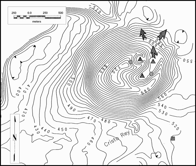 |
Figure 12. Topographic map of Cerro Negro volcano, prepared during 24 February-2 March. The contour interval is 10 m. Shaded triangles indicate the 1995 eruption vents, arrows show the direction of 1995 lava flows from the crater, shaded circles show positions of active fumarole areas, and the shaded square indicates the position of the INETER seismic station. Courtesy of Chuck Conner. |
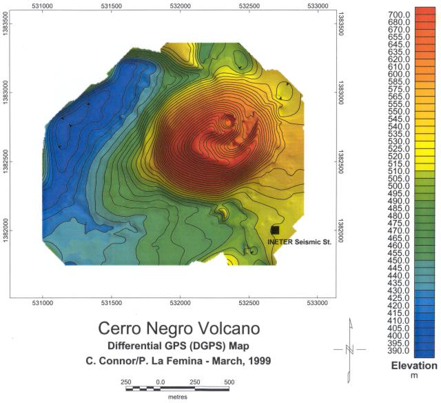 |
Figure 13. Color-shaded topographic map of Cerro Negro volcano, prepared during 24 February-2 March. The contour interval is 10 m. The black square indicates the position of the INETER seismic station. Courtesy of Chuck Conner. |
The cinder cone's morphology was changed significantly by the 1992 and 1995 eruptions. During the 1992 eruption the crater widened and now has an average diameter of 340 m. It was widest, 418 m, along its NE-SW axis because of a broad shoulder of tephra deposited on the SW side of the cone (during the 1992 and 1995 eruptions prevailing wind directions were from the NE). The diameter of the base of the cone was 945 m, measured between Cerro La Mula Ridge to the N of the cone and the Cristo Rey vent on the S. Data derived from air photos taken in 1986 revealed that this basal diameter had not changed substantially since then despite the 1992 and 1995 eruptions. The high point on Cerro Negro was measured at 728 m elevation, giving the cone a height of 258 m when measured relative to a topographic break in slope at the cone base, just west of Cristo Rey vent.
A small pyroclastic cone within the 1992 crater was created during the 1995 eruption. This new cone had a rim diameter of 124-130 m. Its crater depth was 94 m from the W rim (corresponding to the high point on Cerro Negro) and 44 m from the low point on the E side. Lava flows, emitted from at least two boccas on the 1992 crater floor during the 1995 activity, breached the N side of the 1992 cone. Because of this breach the low point on the 1992 crater rim was 9 m below the average rim elevation of 625 m.
No substantial degassing or other signs of volcanic unrest were observed during the seven days that the team was on-site and the area seemed unchanged since the cessation of the 1995 eruption. No thermal activity was observed on the 1995 lava flows, even on flow levees thicker than 3 m. These lava flows appeared to have cooled substantially as a result of the more than 3 m rainfall the region received during Hurricane Mitch in the Fall of 1998. Two fumarole areas were active; one fumarole area on the E of the crater has likely persisted since before the 1992 eruption. These fumaroles were easily accessible due to the breaching of the N crater rim by the 1992 lava flows. A new fumarole area had been established high on the W rim of the 1995 pyroclastic cone, just below the high point on Cerro Negro. Sulfur, anhydrite, and halite were deposited in these areas. Low-temperature fumaroles (<100°C) were found along arcuate fractures that paralleled the 1992 cone rim. These fractures were most prominent on the S side of the cone where they were faulted with 0.1-1.0 m displacements, down toward the outer cone flank and up toward the crater, because of slumping on the outer flank. They were radial on the SW of the cone, where the outer cone slope was buttressed by 1992 and 1995 tephra accumulations. Similar fractures and small faults also occurred on the NW rim and around the 1995 pyroclastic cone. Low-temperature fumaroles were also found on the southernmost 1995 bocca and a small mound within the 1992 crater. Fumaroles and steaming ground persisted on Cerro La Mula Ridge.
Crater fumarole measurements. The temperature of crater fumaroles has been measured during visits by Alain Creusot since 1995 (BGVN 21:11, 21:12, and 23:03). From November 1995, when a significant eruption took place, to October 1996, fumarole temperatures were as high as 700°C. On 27 November 1996, a visit to the crater found that fumarole temperatures had generally decreased by 80-100°C and the maximum temperature was only 630°C. On 23 December 1996 the maximum fumarole temperature was only 606°C. An additional decrease of fumarole temperatures was noted on a 5 September 1997 visit; the maximum temperature measured was only 405°C (previously unreported). The highest temperature found on 14 February 1998 was 340°C.
References. Hill and others, 1998, Eruptions of Cerro Negro volcano, Nicaragua, and risk assessment for future eruptions, Geological Society of America, Bulletin, v. 110, p. 1231-1241.
Connor and others, 1996, Soil 222Rn pulse during the initial phase of the June-August 1995 eruption of Cerro Negro, Nicaragua, Journal of Volcanology and Geothermal Research, vol. 73, p.119-127.
Information Contacts: Chuck Connor, Peter La Femina, Brittain Hill, James Weldy, Center for Nuclear Waste Regulatory Analyses, Southwest Research Institute, 6220 Culebra Rd, San Antonio, TX, 78238-5166; Kurt Roggensack and Berry Cameron, Department of Geological Sciences, Arizona State University, Tempe, AZ; Alain Creusot, Instituto Nicaraguense de Energía, Managua, Nicaragua.
Explosive eruptions starting on 5 August
During the night of 4-5 August 1999, strong seismic activity occurred near Cerro Negro and the earthquakes with magnitudes up to 4.8 were felt throughout NW Nicaragua, especially in the big cities of León (20 km away, where many people could not sleep because of the seismic events) and Chinandega (40 km away). The strongest event was even felt 70 km away in Managua. The Nicaraguan seismic network recorded hundreds of earthquakes and strong seismic tremor at the seismic station at the volcano and at the MIRAMAR station (7 km away).
Three notices were received from the GOES alarm network concerning Cerro Negro. Distinct hot spots, indicating small plumes over the volcano, were detected on infrared satellite imagery at 0055, 0155, and 0235 on 5 August.
Explosive eruptions began at about 1000 on 5 August 1999. Ash clouds at heights of about 7,000 m were reported by aircraft. Ashfall was reported from some places SW of the volcano. The activity issued from four new vents outside the main crater, very near to the parasitic crater Cristo Rey, on the S flank of Cerro Negro. The vents formed cones ~40 m high during the day.
Wilfried Strauch visited the volcano that afternoon and observed explosions every few seconds, sometimes generating lava fountains ~300 m high. The activity alternated among the different new cones. No significant amounts of volcanic ash were emitted at this time. Local residents ~1 km from the volcano reported that seismicity was extremely strong during the night. Fissures appeared in the soil near their houses, releasing vapor.
INETER informed Civil Defense and other institutions on the night of 4 August about the seismic activity. Civil Defense officers visited the volcano early in the morning of 5 August, but could not yet detect signs of volcanic activity. When they got the information about the beginning of the eruption they proceeded with the evacuation of nearby villages, involving several hundreds of people.
Volcanic ash advisory statements on 6 August indicated that well-defined hot spots were still occasionally visible on GOES-8 multi-spectral imagery through 1615. No ash was visible in the imagery at that time, and thick clouds moved over the area later in the day. Imagery obtained under clear skies at 1015 on 7 August revealed no ash or hot spot.
Information Contacts: Wilfried Strauch, Instituto Nicaraguense de Estudios Territoriales (INETER), Division of Geophysics, Apartado 2110, Managua, Nicaragua; Benjamin van Wyk de Vries, Magmas et volcans Observatoire du Physique du Globe, Departement des Sciences de la Terre, Université Blaise Pascal, 5 Rue Kessler, 63038 Clermont-Ferrand, France (URL: http://modis.higp.hawaii.edu/); Washington Volcanic Ash Advisory Center, NOAA Satellite Services Division, NESDIS E/SP23, NOAA Science Center, Room 401, 5200 Auth Road, Camp Springs, MD 20746, USA (URL: http://www.ssd.noaa.gov/).
GOES satellite thermal imagery heralded August 1999 eruption
Renewed effusive activity at Cerro Negro during August 1999 (BGVN 24:11) was heralded by a thermal anomaly in GOES thermal (3.9 mm wavelength) data. These data are processed and displayed in real-time at http://hotspot.higp.hawaii.edu/ to monitor selected hot spots associated with volcanic activity across North, Central, and South America, the Pacific, and the Caribbean. Areas of local focus, or "alert boxes," currently include Cerro Negro, Masaya, and Momotombo. The onset of activity at Cerro Negro triggered an automated threshold-based email alert at 0956 local time on 5 August and was evident from a marked increase in volcanic radiance at that time (figure 14). Volcanic radiance is the residual radiance of the volcano after radiance from the ambient background has been subtracted. This calculation is therefore negative in circumstances of low or no activity and positive when the volcano is sufficiently active to exceed the background ambient radiance.
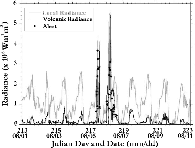 |
Figure 14. Mean GOES mid-infrared (3.9 mm) radiance for a 10 x 10 pixel box centered on Cerro Negro (local radiance, gray line) and for volcanic radiance (as defined by Harris and Thornber, 1999) for the hottest pixel within that box (black line). Waxing and waning hot spot activity on 5 and 6 August, respectively, is related to effusive activity at Cerro Negro. Diamonds indicate occasions when hot spot radiance levels tripped an automated email alert. Courtesy of Andy Harris, Luke Flynn, Eric Pilger, and Benjamin van Wyk de Vries. |
For Cerro Negro, the absence of a thermal anomaly in the GOES data acquired at 0926 coupled with a strong, persistent anomaly from 0956 onwards (figure 14), suggests that effusive activity began at the time 0941 ± 15. Plumes up to 8 km wide and extending 4-19 km to the W and NW were observed on all GOES images acquired between 0956 and 1145 at which point cloud cover obscured Cerro Negro. On the next cloud-free image (1345) and all subsequent images, hot spots only (with no plumes) were observed. Hot spot intensity reached a peak at 0527 on 6 August, before abruptly declining between 0627 and 1356. The absence of a later hot spot suggested that effusion had ended by 1500 on 6 August, having lasted ~28 hours (figure 14). The apparent hiatus between 5 and 6 August was due to cloud cover obscuring the hot spot from the satellite view.
Analysis of these data resulted in the following interpretations. Detection of plumes in the initial stages of eruption correlates with ground reports of ash fall and probably relates to the vents opening. The absence of a later plume suggested fire fountaining with little fine fragmentation. Such activity was also characteristic of the November 1995 eruption (http://tabitha.open.ac.uk/Others/world/vries/cerro_negro/slides.html), and of the 1968 eruption at the Cristo Rey satellitic vent (Viramonte and Di Scala, 1969). The steady hot spot intensity increase followed by a rapid decrease is a pattern similar to observed activity and reported RSAM during the 1995 eruption. The duration of the 1995 eruption was, however, much longer. The siting of the recent vents to the SE may be influenced by the large volume of lava emplaced on the opposite flank during the 1995 eruption. In a similar case, the 1968 eruption, loading of the previously erupted lavas may have influenced both breakout locations.
References. Harris, A.J.L., and Thornber, C., 1999, Complex effusive events at Kīlauea as documented by the GOES satellite and remote video cameras; Bull. Volc., 61(6), 382-395.
Viramonte J.G., and Di Scala, L., 1969, Summary of the 1968 eruption of Cerro Negro, Nicaragua: Bull. Volc., v. 34, p. 346-351.
Information Contacts: Andy Harris, Luke Flynn, and Eric Pilger, HIGP/SOEST, University of Hawai'i, 2525 Correa Road, Honolulu, HI 96822 USA (URL: http://modis.higp.hawaii.edu/); Benjamin van Wyk de Vries, Magmas et Volcans, UPB, Clermont-Ferrand, France.
Low seismicity; fumarole temperatures in March-April 2000
Following the eruptive activity of 5-7 August 1999 (BGVN 24:11), seismicity dropped to low levels, with no more than 12 events/month detected through November 1999. The monthly earthquake totals increased to 31 and 32 events, respectively, during December 1999 and January 2000. These numbers continued to slowly increase, reaching 41 events in February and 46 events in March 2000. Total monthly earthquakes in April dropped to 20 events. Low-level tremor was constant throughout the September 1999-April 2000 period.
Fieldwork during March and April 2000 allowed observations of the August 1999 cones and vent, but no changes were noted. New temperature measurements of fumaroles located in the interior of the main crater were also taken during March and April (table 2). Fumaroles 1, 2, and 3 exhibited a consistent temperature increase. The much hotter fumaroles in March (4, 5, and 6) were more variable, and had cooled by late April.
Table 2. Fumarole temperatures from the main crater area at Cerro Negro, July 1999-April 2000. Measurements were made with a thermocouple in July 1999, December 1999, and March 2000; an infrared pistol was used in April 2000. Courtesy of INETER.
| Date | Fumarole 1 | Fumarole 2 | Fumarole 3 | Fumarole 4 | Fumarole 5 | Fumarole 6 |
| Jul 1999 | 45.0°C | 72.0°C | -- | -- | -- | 85.0°C |
| Dec 1999 | 69.8°C | 60.5°C | 58.0°C | 69.7°C | 232°C | 147°C |
| Mar 2000 | 73.3°C | 60.5°C | 97.0°C | 318°C | 201°C | 206°C |
| 27 Apr 2000 | 91.0°C | 236°C | 110°C | 193°C | 176°C | -- |
Information Contacts: Wilfried Strauch and Virginia Tenorio, Dirección General de Geofísica, Instituto Nicaragüense de Estudios Territoriales (INETER), Apartado 1761, Managua, Nicaragua (URL: http://www.ineter.gob.ni/).
Increased tremor and a new fumarole
During 19-20 February 2002 a slight increase in seismic tremor and some very small earthquakes were registered by a seismic station at Cerro Negro. The increase in tremor varied in amplitude and lasted for 12 hours, from 2300 on 19 February until 1100 on 20 February. Tremor continued to occur at very low (normal) levels for the rest of the day on 20 February until 22 February.
On the morning of 20 February, representatives from Instituto Nicaragüense de Estudios Territoriales (INETER) visited the volcano and made observations of the main crater and small cones that were formed during the 1999 eruption (BGVN 24:11). Compared to a visit on a few days earlier, there were no major changes observed except for the normal intra-crater movements found along collapses, fractures, and small landslides. The visitors noted one small recent landslide and a new fumarole at the E end of the crater. Fumarole temperatures in the main crater were slightly increased compared to previous visits (reaching 409°C, according to news reports). Some fumaroles contained larger volumes of sulfur precipitates and sublimates than seen previously.
News articles stated that on 20 February the Civil Defense reported that a landslide had occurred at Cerro Madre that was ~80-100 m long and 45 m wide.
By 23 February, INETER suggested that the increased tremor observed on 21 February may have been associated with increased gas emissions related to the formation of the new fumarole. Since no major volcanic activity was observed, INETER reported that there was no cause for alarm and no imminent danger for populations bordering the volcano, but that visitors or tourists who enter the crater should be prepared for sudden, unannounced, and possibly dangerous events like gas explosions and landslides.
During 26 February-11 March 2002 scientists from Instituto Tecnológico y de Energías Renovables (ITER) and INETER studied ground temperature, and diffuse H20, CO2, and H2S degassing. The team surveyed 175 sampling sites over an area of ~0.5 km2 . Soil CO2 and H2S flux values ranged from 0.3 to 28,000 g/m2 d, and from 1 to 17,000 mg/m2 d, respectively. Soil temperatures at 40 cm depth ranged from 22 to 453°C, while air temperature ranged from 21 to 46°C. Soil Hg0 gas was also analyzed in situ; its concentration reached up to 204 mg/m3.
Compared to the 2002 survey, the one in 1999 showed similar, though somewhat higher CO2 values, up to 35,000 g/m2 d, and a wider range of ground temperatures, 16 to 707°C (Salazar and others, 2001). The 1999 survey was carried out three months after the most recent eruption at Cerro Negro (BGVN 24:11).
General Reference. Salazar and others, 2001, Diffuse emission of carbon dioxide from Cerro Negro volcano, Nicaragua, Central America: Geophysical Research Letters, v. 28, p. 4275-4278.
Information Contacts: Wilfried Strauch, Dirección General de Geofísica, Instituto Nicaragüense de Estudios Territoriales (INETER), Apartado 1761, Managua, Nicaragua (URL: http://www.ineter.gob.ni/); Nemesio M. Pérez and Gladys Melián, Inés Galindo, Environmental Research Division, Instituto Tecnológico y de Energías Renovables (ITER), 38611 Granadilla, Tenerife, Canary Islands, Spain; El Nuevo Diario (URL: http://www.elnuevodiario.com.ni/); La Prensa (URL: http://www-ni.laprensa.com.ni/).
Slumbering volcano yields uneventful seismic and fumarolic temperature data
Seismic activity has been monitored at Cerro Negro for the past 15 months. From April 2002 seismicity remained low with eight earthquakes registered in May and June. Earthquake activity was moderate in August (32), September (28), and October (28); no earthquakes were registered in November or December. Activity increased again in January 2003, when 91 tectonic events were registered. Activity dropped in February to 14 tectonic events but increased again in March (44 tectonic earthquakes, two of which were located underneath Cerro Negro), April (45), and May (41 volcano-tectonic earthquakes). Tremors remained low (5 RSAM units).
Gas emissions and fumarole temperatures measured by hand-held infrared instrument (table 3) were also monitored over this period. A visit on 12 April 2002 by Pedro Perez of INETER, Eliecer Duarte and Eric Fernandez of OVSICORI-UNA, Costa Rica, and Franco Tassi and Orlando Vaselli of the University of Florence, Italy, found that fumarole temperatures were down from February. Monthly visits to the volcano started in June 2002.
Table 3. Temperatures (°C) of fumaroles (identified by number) at Cerro Negro, June 2002-May 2003. Fumaroles 2-4 are in the crater formed in 1995. Courtesy of INETER.
| Date | Fumarole 1 | Fumarole 2 | Fumarole 3 | Fumarole 4 | Fumarole 6 | Fumarole 7 | Fumarole 8 |
| 05 Jun 2002 | 252 | -- | -- | -- | -- | -- | -- |
| 28 Aug 2002 | 255 | -- | -- | -- | -- | 184 | 189 |
| 09 Sep 2002 | 257 | -- | -- | -- | 175 | 184 | 189 |
| 18 Oct 2002 | 326 | -- | -- | -- | 157 | 223 | 188 |
| 21 Nov 2002 | 475 | 564 | 245 | 475 | -- | -- | -- |
| 22 Nov 2002 | 448 | 479 | 200 | 207 | -- | -- | -- |
| 05 Dec 2002 | 403 | 508 | 385 | 208 | -- | -- | 316 / 278 |
| 09 Jan 2003 | 402 | 486 | 494 | 402 | -- | -- | -- |
| 10 Feb 2003 | 402 | 486 | 494 | 402 | -- | -- | -- |
| 21 Mar 2003 | 468 | -- | -- | -- | -- | -- | -- |
| 04 Apr 2003 | 388 | -- | -- | -- | -- | -- | -- |
| 03 May 2003 | 399 | 78.6 | 226 | -- | 239 | 203 | 255 |
On 5 June, following heavy rain, steam was observed exiting the fissure SE of the volcano. Observations on 18 July noted abundant gas emissions at all fumaroles and a strong scent of sulfur around the entire crater. Emissions continued on the SE fissure and in Este del Cerro La Mula. On 28 August, Perez observed gas emissions at fumarole 4 and a continued sulfur odor. Falling rocks were observed in the inner crater. Few gas emissions were observed on 9 September and 18 October, but the strong scent of sulfur persisted. No landslides were observed. Gas emissions were observed at the fumaroles of Este del Cerro La Mula with greater abundance than in previous months.
Perez visited again on 21 November and during 25-27 November, accompanied by Matthias Frische, Kris Garofalo, Thor Hansten, and Boo Gall (GEOMAR Germany). The maximum measured temperature in the new crater was 564°C and for fumarole 1 of the old crater the temperature was 334°C.
The sampling that began in November continued in the following months. On 5 December temperatures continued to be high in the cone formed in 1995. The maximum fumarole temperature on the new cone was 494°C. The visit on 10 February included more sampling, but no physical change was observed at the volcano. Recorded temperatures did not vary from those made in January. Temperature measurements at fumarole 1 on 21 March 2003 revealed an increase of 66°C from February. On 30 and 31 March there was a slight increase of 20 RSAM units and officials observed the volcano for several hours, witnessing no anomolies. On 4 April more temperature measurements and gas sampling were performed and rock was noted to be loosening in fumarole 4. On 3 May the temperatures of the fumaroles located within the crater were constant with respect to the previous months, with the exception of fumarole 6, which had an increase of 100°C. Strong gas emissions were observed in parts of the inner crater.
Information Contacts: Pedro Perez, Armando Saballos, and Aduardo Mayorga, Instituto Nicaragüense de Estudios Territoriales (INETER), Apartado 1761, Managua, Nicaragua (URL: http://www.ineter.gob.ni/).
Non-eruptive activity; fumarole and seismic monitoring; new crater morphology
Cerro Negro remained non-eruptive from 2003 to 2011; explosive activity was last recorded in December 1999 (BGVN 24:11). Our last report reviewed Cerro Negro's fumarolic field observations, including descriptions of passive degassing and measurements of temperatures from June 2002 through May 2003, provided courtesy of Instituto Nicaragüense de Estudios Territoriales (INETER) and international collaborators (BGVN 28:07). No volcanic ash advisory reports for the area of Cerro Negro were released by the Washington VAAC office during 2003-2011. The following report reviews seismicity from 2003 to 2011, field observations, and emission measurements provided by INETER. The primary physical features of Cerro Negro highlighted in this report include the 1992 and 1995 central craters as well as the three 1999 craters, which continued to steam in 2007 (figure 15).
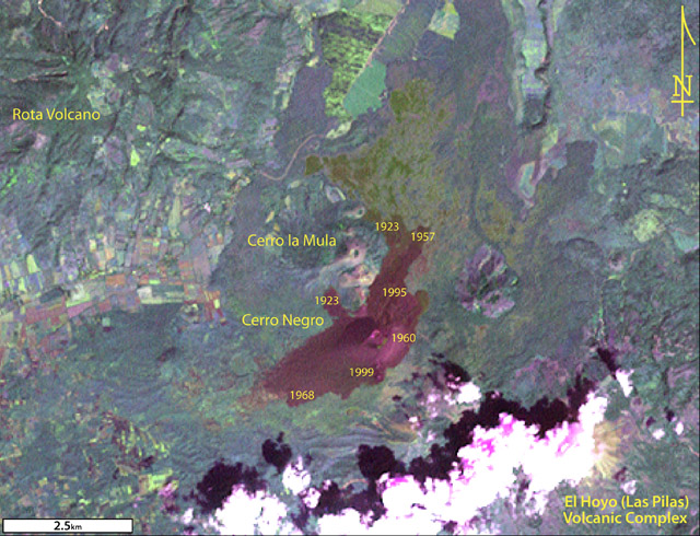 |
Figure 15. A composite Landsat 7 ETM+ image of Cerro Negro processed by GVP with geospatial software (NASA Landsat Program, 2003). The image had an original resolution of 30 m and was collected on 15 November 1999. Lava flow ages shown (1923 to 1999) are based on GVP online photo captions ("Photo Gallery") and published literature by McKnight and Williams (1997) and Hill and others (1998). |
Figure 15 consists of a false-color image made from visible, near- and mid-infrared bands (3,7,2) to enhance geological features. Cerro Negro appears dark-red in the center of the image. The central cone, which was the source of many lava flows, lies immediately to the left of "1960" (the label dating the eruption associated with one of the lava flows). The tiny, arcuate pink and green zones at the central cone represent the rim of the nested craters there. Those craters are the scene of the highest fumarolic activity.
On the cone's S flanks, the three small cones created during the 1999 eruption appear as bright pink points. In figure 15 these appear immediately right of "1999".
Several volcanoes of the NW trending Marrabios range of Western Nicaragua are labeled on figure 15. Along the range to the SE is the historically active El Hoyo (Las Pilas) volcanic complex, which in figure 15 is partly cloud-covered. The complex includes Las Pilas, Cerro Grande, and Cerro Ojo de Agua eruptive centers. To the N and NW of Cerro Negro lie the volcanic centers Cerro la Mula and Rota.
Post-eruptive seismicity from 1999 to 2003. The INETER December 2003 report discussed seismicity after the small-scale, cone-forming events in 1999. INETER described Cerro Negro as relatively quiet since the 1999 episode; minor ash and gas explosions occurred as late as 25 December 1999. Earthquake counts from August 1999 to December 2003 ranged from 40 to 100 earthquakes per month, typically volcanic-tectonic (VT) events. Low amplitude tremor (frequency ranges of 8-19 Hz) was detected throughout 2003.
Figure 16 depicts multi-year seismicity and illustrates comparitive highs during 2003, particularly in January, September, and December when the the number of monthly earthquakes rose to over 100. These swarms led to counts roughly 10-fold higher than the 18-month interval of quiet from middle to late 2001. The later seismic swarm, occurring from 30 to 31 December, comprised 37 events too small to locate.
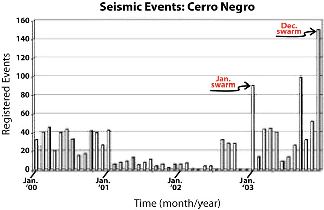 |
Figure 16. Histogram presenting the number of earthquakes recorded at Cerro Negro from January 2000 through December 2003. Two swarms occurred during 2003 (labeled). Courtesy of INETER. |
During 2003, INETER visited the volcano and found the scene without visible sign of change, without felt earthquakes, and lacking anomalous gas emissions. Fumarole temperatures from eight sites were in the range ~100-400°C. The only anomalous temperature increase in 2003 appeared at two fumaroles measuring ~550°C on 27 August. That was an increase of more than 200°C since July 2003.
2004 banded tremor and elevated seismicity. Although not ploted on figure 16, elevated seismicity continued through January, February, and March 2004. Banded tremor was recorded until 20 January, when it began to diminish. In January, RSAM was not greater than 50 units, but several cautionary public announcements were made regarding persistent tremor and its typical association with explosive activity.
Although INETER reported decreased tremor toward the end of January 2004, a seismic swarm occurred from 23 to 27 January. On 26 January the highest number of earthquakes registered (203 earthquakes, ~50 more than high of December 2003).
Of the ~1,200 earthquakes registered during January 2004, only three were located. During 3-29 February, ~400 events were registered and 33 were located. In March, 23 earthquakes were located and during the following months, significant events became rare averaging ~3 events located per month for the rest of the year. In March, tremor reached only 5 RSAM units.
Field visits by INETER determined that fumarole temperatures in March, May, June, and July 2004, ~50-350°C, spanned a wider range than those from the previous year. INETER had been measuring temperatures from several fumaroles (three to eight sites) within the crater since 1999 (figure 12 in BGVN 24:06 shows two primary fumarole locations in a map developed after major crater changes in 1995).
Press accounts regarding the seismic swarms. Officials interviewed by the newspaper La Prensa on 17 January 2004 included the mayor of León, who stated that the municipality's Emergency Committee was activated and on standby. The director of INETER's Volcanology program, Martha Navarro, also explained that caution was merited due to experience from Cerro Negro's 1999 escalation. Similar seismic tremor was recorded recently from the volcano, but conditions had clearly changed since 1999 and no explosions had occurred. The director also noted that on 11 January 2004 visiting scientists had looked for substantial sulfur-dioxide emissions but found them absent.
On 22 January 2004, a Civil Defense representative told La Prensa that recent reports of plumes from the crater were false and that no physical changes had occurred at Cerro Negro during the December-January seismic unrest. Passive degassing had been occurring at the summit and from fumaroles since the 1999 events but may have appeared anomalous to local observers. Regular monitoring by INETER had shown elevated temperatures from the fumaroles and steam frequently escaped from the three 1999 cinder cones (figure 15). According to La Prensa, the Civil Defense representative also shared details regarding new installations of seismic stations and gas-monitoring sites. A collaborative effort between Civil Defense and INETER made this possible.
2005-2011 rockfalls and altered crater morphology. Routine monitoring by INETER from 2005 through 2011 has been recorded in monthly reports available online in Spanish with English abstracts, works that chiefly documented passive degassing through this time period. Fumarole temperatures ranged from 13°C to ~400°C. In May 2003, seven fumaroles had elevated temperatures (BGVN 28:07), but in April 2008, six of these sites had ceased discharging measurable emissions. By July 2008, four fumarole sites were emitting gas and elevated temperatures ranging from 96 to 285°C that month and appeared stable through 2011.
INETER began reporting significant rockfalls along Cerro Negro's S and SW interior crater walls in 2009. These rockfalls continued through 2011 and released meter-sized blocks of coherent rock as well as highly altered material that collected within the crater (figure 17). INETER suggested that some of the large rockfalls may have been caused by large rainfalls, particularly those events during July 2009 and May-July 2010.
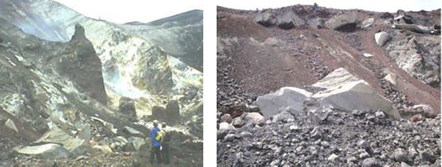 |
Figure 17. Photos of the S and SW interior crater walls of Cerro Negro. (Left) A photo (with people for scale) taken in August 2009 shows meter-sized blocks had collected on the crater floor and (in the middle ground) a diffuse plume from fumarolic degassing. (Right) A photo taken in September 2009 depicts massive blocks cropping out along the upper portion of the near-vertical wall and extensive areas of loose scree and blocks that have already fallen free. Courtesy of INETER. |
A significant geomorphic change at Cerro Negro was noted by INETER investigators on 11 January 2011. A N-trending fault had appeared since the last field visit (10 November 2010) on the SE interior crater wall (figure 18). Offset along the fault measured ~30 cm. Based on field relations INETER suggested this feature appeared gradually. The fault intersected fumarole ##1, a reliable site for thermal measurements. A major system of normal faults had already been documented to the NW of Cerro Negro, and the new fault on the cone appeared to trend parallel to it.
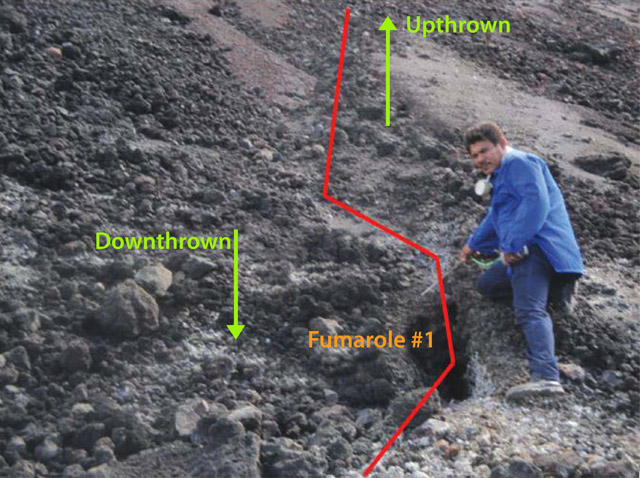 |
Figure 18. Observations made on 11 January 2011 by INETER detail the surface expression of a new fault intersecting fumarole ##1 on the SE segment of the interior crater wall (viewed looking S). The terms 'Upthrown' and 'Downthrown' refer to relative motion on the fault. The fault trends N-S and underwent ~30 cm of lateral displacement. Courtesy of INETER. |
Seismicity at Cerro Negro remained generally low from 2005 through 2011 although tremor was detected regularly. At times, tremor was as low as 5 RSAM units (July 2009) and as high as 30 (December 2010 and September 2011). Numerous VT events were recorded in 2006 (~347) and in 2011 (~240) and accordingly, the number of significant located events was higher for those years as well, 25 and 32, respectively (table 4).
Table 4. Significant earthquakes located near Cerro Negro from 2003 through 2011. For each year, the table lists the number of located earthquakes, range of local magnitudes (ML), range of focal depths, and most frequently-occurring focal depth. Courtesy of INETER.
| Year | # EQs | ML | Depth1 (km) | Depth2 (km) |
| 2003 | 13 | 1.5-3.3 | 0-8 | 2 |
| 2004 | 86 | 0.6-2.7 | 0-13 | 0 |
| 2005 | 23 | 1.0-2.6 | 1-61 | 2 |
| 2006 | 25 | 0.8-3.3 | 1-157 | 2 |
| 2007 | 6 | 1.9-2.8 | 2-6 | 6 |
| 2008 | 5 | 0.5-3.1 | 1-194 | 2 |
| 2009 | 1 | 3.1 | 4 | 4 |
| 2010 | 6 | 1.5-2.8 | 2-88 | 3 |
| 2011 | 32 | 0.5-3.5 | 0-140 | 3 |
The range of focal depths was relatively large in 2006 and 2011. The deepest earthquake during 2003-2011 struck on 23 December 2008 with local magnitude (ML) 3.1 and located ~190 km below sea level. The most frequently occurring focal depth during 2005-2011 was very shallow, 2 km below sea level, under ML 3.5.
During field campaigns on 21-27 February 2011, a collaborative effort between Spain's Instituto Tecnológico y de Energías Renovables (ITER) and INETER mapped the spatial CO2-flux pattern. The team was able to map CO2 fluxes from multiple diffuse sources over the cone and within Cerro Negro's 1992 and 1995 craters (figure 19). An overall total CO2 flux of 43 tons per day was determined; a similar measurement was obtained in 2010 (44 tons per day). Collaborative efforts between ITER and INETER have applied this mapping technique since 1999 in order to locate anomalous areas of emissions from the cone and to calculate total flux (Dionis, S. and others 2010). These investigators noted that the years following the 1999 explosion were marked by decreasing levels of CO2 however, an increasing trend appeared from December 2008 to March 2009; values ranged from 12 tons per day to 38 tons per day.
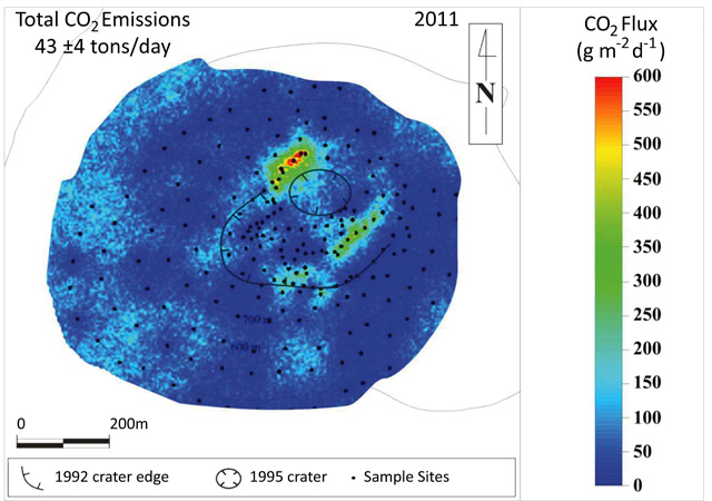 |
Figure 19. Results of a CO2 measuring campaign from 21 to 27 February 2011. Courtesy of ITER and INETER. |
References. Dionis, S., Melián, G., Barrancos, J., Padilla, G., Calvo, D., Rodríguez, F., Padrón, E., Nolasco, D., Hernández, Pedro A., Pérez, N. M., Ibarra, M., and Muñoz, A., 2010. Dynamics of diffuse CO2 emission and eruptive cycle at Cerro Negro volcano, Nicaragua, Cities on Volcanoes 6, Puerto de la Cruz, Tenerife, 31 May-4 June, 2010, Abs, p 103.
Hill, B. E., Connor, C.B, Jarzemba, M.S., La Femina, P.C., Navarro, M., and Strauch, W., 1998, 1995 eruptions of Cerro Negro volcano, Nicaragua, and risk assessment for future eruptions, Geological Society of America Bulletin, 110, no. 10;1231-1241.
NASA Landsat Program, 2003, Landsat ETM+ scene 7dt19991115, SLC-Off, USGS, Sioux Falls, Nov. 15, 1999.
McKnight, S.B. and Williams, S.N., 1997, Old cinder cone or young composite volcano?: The nature of Cerro Negro, Nicaragua, Geology, 25, 339-342.
Information Contacts: Instituto Nicaragüense de Estudios Territoriales (INETER), Apartado Postal 2110, Managua, Nicaragua (URL: http://www.ineter.gob.ni/); Global Land Cover Facility ( URL: http:// http://www.glcf.umiacs.umd.edu/); Instituto Tecnológico y de Energías Renovables (ITER), 38611 Granadilla, Tenerife, Canary Islands, Spain (URL: http://www.iter.es/); Washington Volcanic Ash Advisory Center (VAAC), Satellite Analysis Branch (SAB), NOAA/NESDIS E/SP23, NOAA Science Center Room 401, 5200 Auth Rd, Camp Springs, MD 20746, USA (URL: http://www.ospo.noaa.gov/Products/atmosphere/vaac/); La Prensa de Nicaragua, Managua, Nicaragua (URL: http://www.laprensa.com.ni/).
Seismic swarm in 2013
Since our last report (BGVN 37:01), Instituto Nicaragüense de Estudios Territoriales (INETER) continued to conduct fieldwork at Cerro Negro during 2012-2013 and reported that stable conditions prevailed except for a small seismic swarm detected in 2013.
INETER reported that from Cerro Negro's activity during 2012 was considered normal. Several significant landslides occurred that year, particularly from the S-SW interior rim of the primary crater. Seismicity was variable throughout the year with some interruptions of the signal (table 5).
Table 5. Seismicity was reported in INETER monthly reports during January-June 2012. Note that representative values are presented in the RSAM column (not mathematical averages) whereas the Max RSAM column contains the highest value recorded each month. There was a station outage during part of January. Courtesy of INETER.
| Month | EQ Count | RSAM | Max RSAM | Tremor (hours/day) |
| Jan 2012 | 43 | ~20 | 160 | -- |
| Feb 2012 | 85 | ~20 | 80 | 3-18 |
| Mar 2012 | 76 | ~50 | 255 | 1-16 |
| Apr 2012 | 162 | ~20 | 50 | 1-15 |
| May 2012 | 111 | 12-30 | 65 | some |
| Jun 2012 | 179 | 10-20 | 45 | 1 |
A gas measurement campaign was conducted within Cerro Negro's main crater in collaboration with the Instituto Tecnologicos de Energias Renovables (ITER) in late 2012. During the course of fieldwork, on 26 and 30 November, and 1 December, the team measured diffuse CO2 emissions from the soil at 219 points. The preliminary results showed normal levels, ~33 tons per day, compared to past results from this area.
Temperature measurements for 2012 were reported based on the four different fumarolic sites within the main crater (figure 20). The range varied between 50 and 325 degrees C.
|
Figure 20. Temperature measurements from Cerro Negro's crater summarized for 2011-2013. Data were collected December 2011-May 2013. Four different fumaroles were sampled and measured (fumaroles 1, 2, 3, and 6; for locations see figure 21). The data were collected at intervals of days and many are shown here (as in the original INETER plot) connected with line segments. Courtesy of INETER. |
|
Figure 21. The location of the four measured fumaroles located within Cerro Negro's largest crater. The view is approximately to the N. Courtesy of INETER. |
Field investigations during March-June 2013 yielded additional observations of rockfalls and slides within the main crater. INETER also measured temperatures from the four fumarolic sites and concluded that steady conditions persisted (figure 20).
INETER reported a seismic swarm on 4 June 2013. RSAM had increased 60 units; 49 earthquakes were detected but were too small to be located. INETER maintained Alert Status Green and released informational statements to the media that described their response to the escalation and they also highlighted the potential of hazardous gas emissions for the area. The Sistema Nacional para Prevención, Mitigación y Atención de Desastres (SINAPRED) suggested that local residents and tourists in the area should be cautious around the flanks of Cerro Negro due to the possibility of rockfalls triggered by seismic events.
As a response to the increased seismicity that month, INETER conducted hot spring sampling and gas measuring campaigns in the area of Cerro Negro during 6-7 June. A team of fieldworkers focused on diffuse CO2 flux from the soil in a fault area on the W side of the Las Pilas-El Hoyo complex (SE of Cerro Negro, figure 15 in BGVN 37:01). The team took measurements 5 m apart at 91 points along a fault scarp, with depths of 11 and 40 cm within the soil; those measurements indicate an average flux of 59-80 ppm/s. No additional seismic unrest was reported during the month.
Information Contacts: Instituto Nicaragüense de Estudios Territoriales (INETER), Apartado Postal 2110, Managua, Nicaragua (URL: http://www.ineter.gob.ni/); Instituto Tecnológico y de Energías Renovables (ITER), 38611 Granadilla, Tenerife, Canary Islands, Spain (URL: http://www.iter.es/); Hoy: El Periodico que yo quiero, Managua, Nicaragua (URL: http://www.hoy.com.ni/2013/06/05/vigilan-al-volcán-cerro-negro/); and Sistema Nacional para Prevención, Mitigación y Atención de Desastres (SINAPRED), Managua, Nicaragua (URL: http://www.sinapred.gob.ni/).
|
|
||||||||||||||||||||||||||
There is data available for 23 confirmed eruptive periods.
1999 Aug 5 - 1999 Aug 7 Confirmed Eruption (Explosive / Effusive) VEI: 2
| Episode 1 | Eruption (Explosive / Effusive) | South flank (near Cristo Rey crater) | |||||||||||||||||||||||||||||||||||||||||||||||||||||||||||||||
|---|---|---|---|---|---|---|---|---|---|---|---|---|---|---|---|---|---|---|---|---|---|---|---|---|---|---|---|---|---|---|---|---|---|---|---|---|---|---|---|---|---|---|---|---|---|---|---|---|---|---|---|---|---|---|---|---|---|---|---|---|---|---|---|---|
| 1999 Aug 5 - 1999 Aug 7 | Evidence from Observations: Reported | |||||||||||||||||||||||||||||||||||||||||||||||||||||||||||||||
|
List of 11 Events for Episode 1 at South flank (near Cristo Rey crater)
|
||||||||||||||||||||||||||||||||||||||||||||||||||||||||||||||||
1995 May 29 - 1995 Dec 6 Confirmed Eruption (Explosive / Effusive) VEI: 2
| Episode 1 | Eruption (Explosive / Effusive) | |||||||||||||||||||||||||||||||||||||||||||||||||||||||||||||||||||||||||||||||
|---|---|---|---|---|---|---|---|---|---|---|---|---|---|---|---|---|---|---|---|---|---|---|---|---|---|---|---|---|---|---|---|---|---|---|---|---|---|---|---|---|---|---|---|---|---|---|---|---|---|---|---|---|---|---|---|---|---|---|---|---|---|---|---|---|---|---|---|---|---|---|---|---|---|---|---|---|---|---|---|
| 1995 May 29 - 1995 Dec 6 | Evidence from Observations: Reported | ||||||||||||||||||||||||||||||||||||||||||||||||||||||||||||||||||||||||||||||
|
List of 14 Events for Episode 1
|
|||||||||||||||||||||||||||||||||||||||||||||||||||||||||||||||||||||||||||||||
1992 Apr 9 - 1992 Apr 14 Confirmed Eruption (Explosive / Effusive) VEI: 3
| Episode 1 | Eruption (Explosive / Effusive) | ||||||||||||||||||||||||||||||||||||||||||||||||||||||||||||||||
|---|---|---|---|---|---|---|---|---|---|---|---|---|---|---|---|---|---|---|---|---|---|---|---|---|---|---|---|---|---|---|---|---|---|---|---|---|---|---|---|---|---|---|---|---|---|---|---|---|---|---|---|---|---|---|---|---|---|---|---|---|---|---|---|---|
| 1992 Apr 9 - 1992 Apr 14 | Evidence from Observations: Reported | |||||||||||||||||||||||||||||||||||||||||||||||||||||||||||||||
|
List of 11 Events for Episode 1
|
||||||||||||||||||||||||||||||||||||||||||||||||||||||||||||||||
1971 Feb 3 - 1971 Feb 14 Confirmed Eruption (Explosive / Effusive) VEI: 3
| Episode 1 | Eruption (Explosive / Effusive) | Summit and east flank | ||||||||||||||||||||||||||||||||||||||||||||||||||||||||||
|---|---|---|---|---|---|---|---|---|---|---|---|---|---|---|---|---|---|---|---|---|---|---|---|---|---|---|---|---|---|---|---|---|---|---|---|---|---|---|---|---|---|---|---|---|---|---|---|---|---|---|---|---|---|---|---|---|---|---|---|
| 1971 Feb 3 - 1971 Feb 14 | Evidence from Observations: Reported | ||||||||||||||||||||||||||||||||||||||||||||||||||||||||||
|
List of 10 Events for Episode 1 at Summit and east flank
|
|||||||||||||||||||||||||||||||||||||||||||||||||||||||||||
1969 Dec 19 - 1969 Dec 29 Confirmed Eruption (Explosive / Effusive) VEI: 1
| Episode 1 | Eruption (Explosive / Effusive) | |||||||||||||||||||||||||||||
|---|---|---|---|---|---|---|---|---|---|---|---|---|---|---|---|---|---|---|---|---|---|---|---|---|---|---|---|---|---|
| 1969 Dec 19 - 1969 Dec 29 | Evidence from Observations: Reported | ||||||||||||||||||||||||||||
|
List of 4 Events for Episode 1
|
|||||||||||||||||||||||||||||
1968 Oct 23 - 1968 Dec 10 Confirmed Eruption (Explosive / Effusive) VEI: 3
| Episode 1 | Eruption (Explosive / Effusive) | Summit and south flank | |||||||||||||||||||||||||||||||||||||||||||||||||||||||||||||||||||||||||
|---|---|---|---|---|---|---|---|---|---|---|---|---|---|---|---|---|---|---|---|---|---|---|---|---|---|---|---|---|---|---|---|---|---|---|---|---|---|---|---|---|---|---|---|---|---|---|---|---|---|---|---|---|---|---|---|---|---|---|---|---|---|---|---|---|---|---|---|---|---|---|---|---|---|---|
| 1968 Oct 23 - 1968 Dec 10 | Evidence from Observations: Reported | |||||||||||||||||||||||||||||||||||||||||||||||||||||||||||||||||||||||||
|
List of 13 Events for Episode 1 at Summit and south flank
|
||||||||||||||||||||||||||||||||||||||||||||||||||||||||||||||||||||||||||
[ 1964 Jul 2 ± 182 days ] Uncertain Eruption
| Episode 1 | Eruption (Explosive / Effusive) | ||||||||||||||
|---|---|---|---|---|---|---|---|---|---|---|---|---|---|---|
| 1964 Jul 2 ± 182 days - Unknown | Evidence from Unknown | |||||||||||||
|
List of 1 Events for Episode 1
|
||||||||||||||
1963 Mar 16 ± 15 days Confirmed Eruption (Explosive / Effusive) VEI: 1
| Episode 1 | Eruption (Explosive / Effusive) | ||||||||||||||||||||||||
|---|---|---|---|---|---|---|---|---|---|---|---|---|---|---|---|---|---|---|---|---|---|---|---|---|
| 1963 Mar 16 ± 15 days - Unknown | Evidence from Observations: Reported | |||||||||||||||||||||||
|
List of 3 Events for Episode 1
|
||||||||||||||||||||||||
1962 Mar 21 - 1962 Apr 16 (?) ± 15 days Confirmed Eruption (Explosive / Effusive) VEI: 2
| Episode 1 | Eruption (Explosive / Effusive) | |||||||||||||||||||||||||||||
|---|---|---|---|---|---|---|---|---|---|---|---|---|---|---|---|---|---|---|---|---|---|---|---|---|---|---|---|---|---|
| 1962 Mar 21 - 1962 Apr 16 (?) ± 15 days | Evidence from Observations: Reported | ||||||||||||||||||||||||||||
|
List of 4 Events for Episode 1
|
|||||||||||||||||||||||||||||
1961 Oct 25 Confirmed Eruption (Explosive / Effusive) VEI: 1
| Episode 1 | Eruption (Explosive / Effusive) | NE-flank fissure | |||||||||||||||||||||||
|---|---|---|---|---|---|---|---|---|---|---|---|---|---|---|---|---|---|---|---|---|---|---|---|---|
| 1961 Oct 25 - Unknown | Evidence from Observations: Reported | |||||||||||||||||||||||
|
List of 3 Events for Episode 1 at NE-flank fissure
|
||||||||||||||||||||||||
1960 Sep 28 - 1960 Dec 26 ± 5 days Confirmed Eruption (Explosive / Effusive) VEI: 3
| Episode 1 | Eruption (Explosive / Effusive) | Summit and south flank | |||||||||||||||||||||||||||||||||||||||||||
|---|---|---|---|---|---|---|---|---|---|---|---|---|---|---|---|---|---|---|---|---|---|---|---|---|---|---|---|---|---|---|---|---|---|---|---|---|---|---|---|---|---|---|---|---|
| 1960 Sep 28 - 1960 Dec 26 ± 5 days | Evidence from Observations: Reported | |||||||||||||||||||||||||||||||||||||||||||
|
List of 7 Events for Episode 1 at Summit and south flank
|
||||||||||||||||||||||||||||||||||||||||||||
1957 Sep 4 - 1957 Sep 24 Confirmed Eruption (Explosive / Effusive) VEI: 2
| Episode 1 | Eruption (Explosive / Effusive) | Summit and east flank | ||||||||||||||||||||||||||||||||||||||||||||||||
|---|---|---|---|---|---|---|---|---|---|---|---|---|---|---|---|---|---|---|---|---|---|---|---|---|---|---|---|---|---|---|---|---|---|---|---|---|---|---|---|---|---|---|---|---|---|---|---|---|---|
| 1957 Sep 4 - 1957 Sep 24 | Evidence from Observations: Reported | ||||||||||||||||||||||||||||||||||||||||||||||||
|
List of 8 Events for Episode 1 at Summit and east flank
|
|||||||||||||||||||||||||||||||||||||||||||||||||
1954 Feb 16 ± 15 days - 1954 Feb 16 ± 15 days Confirmed Eruption (Explosive / Effusive) VEI: 2 (?)
| Episode 1 | Eruption (Explosive / Effusive) | ||||||||||||||||||||||||
|---|---|---|---|---|---|---|---|---|---|---|---|---|---|---|---|---|---|---|---|---|---|---|---|---|
| 1954 Feb 16 ± 15 days - 1954 Feb 16 ± 15 days | Evidence from Observations: Reported | |||||||||||||||||||||||
|
List of 3 Events for Episode 1
|
||||||||||||||||||||||||
1950 Nov 21 - 1950 Dec 17 Confirmed Eruption (Explosive / Effusive) VEI: 3
| Episode 1 | Eruption (Explosive / Effusive) | |||||||||||||||||||||||||||||||||||||||||||||||||
|---|---|---|---|---|---|---|---|---|---|---|---|---|---|---|---|---|---|---|---|---|---|---|---|---|---|---|---|---|---|---|---|---|---|---|---|---|---|---|---|---|---|---|---|---|---|---|---|---|---|
| 1950 Nov 21 - 1950 Dec 17 | Evidence from Observations: Reported | ||||||||||||||||||||||||||||||||||||||||||||||||
|
List of 8 Events for Episode 1
|
|||||||||||||||||||||||||||||||||||||||||||||||||
1949 Jun - 1949 Jun Confirmed Eruption (Explosive / Effusive) VEI: 2
| Episode 1 | Eruption (Explosive / Effusive) | ||||||||||||||||||||||||
|---|---|---|---|---|---|---|---|---|---|---|---|---|---|---|---|---|---|---|---|---|---|---|---|---|
| 1949 Jun - 1949 Jun | Evidence from Observations: Reported | |||||||||||||||||||||||
|
List of 3 Events for Episode 1
|
||||||||||||||||||||||||
1948 Mar 31 Confirmed Eruption (Explosive / Effusive) VEI: 2
| Episode 1 | Eruption (Explosive / Effusive) | ||||||||||||||||||||||||
|---|---|---|---|---|---|---|---|---|---|---|---|---|---|---|---|---|---|---|---|---|---|---|---|---|
| 1948 Mar 31 - Unknown | Evidence from Observations: Reported | |||||||||||||||||||||||
|
List of 3 Events for Episode 1
|
||||||||||||||||||||||||
1947 Jul 9 - 1947 Aug 2 Confirmed Eruption (Explosive / Effusive) VEI: 3
| Episode 1 | Eruption (Explosive / Effusive) | Summit and NE flank | |||||||||||||||||||||||||||||||||||||||||||||||||||||||||||||||
|---|---|---|---|---|---|---|---|---|---|---|---|---|---|---|---|---|---|---|---|---|---|---|---|---|---|---|---|---|---|---|---|---|---|---|---|---|---|---|---|---|---|---|---|---|---|---|---|---|---|---|---|---|---|---|---|---|---|---|---|---|---|---|---|---|
| 1947 Jul 9 - 1947 Aug 2 | Evidence from Observations: Reported | |||||||||||||||||||||||||||||||||||||||||||||||||||||||||||||||
|
List of 11 Events for Episode 1 at Summit and NE flank
|
||||||||||||||||||||||||||||||||||||||||||||||||||||||||||||||||
1929 Feb 10 - 1929 Mar Confirmed Eruption (Explosive / Effusive) VEI: 2
| Episode 1 | Eruption (Explosive / Effusive) | ||||||||||||||||||||||||
|---|---|---|---|---|---|---|---|---|---|---|---|---|---|---|---|---|---|---|---|---|---|---|---|---|
| 1929 Feb 10 - 1929 Mar | Evidence from Observations: Reported | |||||||||||||||||||||||
|
List of 3 Events for Episode 1
|
||||||||||||||||||||||||
1923 Oct 23 - 1923 Dec 11 Confirmed Eruption (Explosive / Effusive) VEI: 3
| Episode 1 | Eruption (Explosive / Effusive) | Summit and upper north flank | ||||||||||||||||||||||||||||||||||||||
|---|---|---|---|---|---|---|---|---|---|---|---|---|---|---|---|---|---|---|---|---|---|---|---|---|---|---|---|---|---|---|---|---|---|---|---|---|---|---|---|
| 1923 Oct 23 - 1923 Dec 11 | Evidence from Observations: Reported | ||||||||||||||||||||||||||||||||||||||
|
List of 6 Events for Episode 1 at Summit and upper north flank
|
|||||||||||||||||||||||||||||||||||||||
1919 Jun 20 - 1919 Jun 30 Confirmed Eruption (Explosive / Effusive) VEI: 2
| Episode 1 | Eruption (Explosive / Effusive) | ||||||||||||||||||||||||
|---|---|---|---|---|---|---|---|---|---|---|---|---|---|---|---|---|---|---|---|---|---|---|---|---|
| 1919 Jun 20 - 1919 Jun 30 | Evidence from Observations: Reported | |||||||||||||||||||||||
|
List of 3 Events for Episode 1
|
||||||||||||||||||||||||
1914 Oct 28 - 1914 Nov 3 Confirmed Eruption (Explosive / Effusive) VEI: 2
| Episode 1 | Eruption (Explosive / Effusive) | ||||||||||||||||||||||||||||||||||||||||||||||||||||||
|---|---|---|---|---|---|---|---|---|---|---|---|---|---|---|---|---|---|---|---|---|---|---|---|---|---|---|---|---|---|---|---|---|---|---|---|---|---|---|---|---|---|---|---|---|---|---|---|---|---|---|---|---|---|---|
| 1914 Oct 28 - 1914 Nov 3 | Evidence from Observations: Reported | |||||||||||||||||||||||||||||||||||||||||||||||||||||
|
List of 9 Events for Episode 1
|
||||||||||||||||||||||||||||||||||||||||||||||||||||||
1899 Nov 22 - 1899 Nov 29 ± 1 days Confirmed Eruption (Explosive / Effusive) VEI: 2
| Episode 1 | Eruption (Explosive / Effusive) | |||||||||||||||||||||||||||||
|---|---|---|---|---|---|---|---|---|---|---|---|---|---|---|---|---|---|---|---|---|---|---|---|---|---|---|---|---|---|
| 1899 Nov 22 - 1899 Nov 29 ± 1 days | Evidence from Observations: Reported | ||||||||||||||||||||||||||||
|
List of 4 Events for Episode 1
|
|||||||||||||||||||||||||||||
1867 Nov 14 - 1867 Nov 30 Confirmed Eruption (Explosive / Effusive) VEI: 2
| Episode 1 | Eruption (Explosive / Effusive) | NE-SW-trending fissure | |||||||||||||||||||||||||||||||||||||||||||
|---|---|---|---|---|---|---|---|---|---|---|---|---|---|---|---|---|---|---|---|---|---|---|---|---|---|---|---|---|---|---|---|---|---|---|---|---|---|---|---|---|---|---|---|---|
| 1867 Nov 14 - 1867 Nov 30 | Evidence from Observations: Reported | |||||||||||||||||||||||||||||||||||||||||||
|
List of 7 Events for Episode 1 at NE-SW-trending fissure
|
||||||||||||||||||||||||||||||||||||||||||||
1850 Apr 13 - 1850 May 27 Confirmed Eruption (Explosive / Effusive) VEI: 2
| Episode 1 | Eruption (Explosive / Effusive) | ||||||||||||||||||||||||||||||||||||||||||||||||||||||
|---|---|---|---|---|---|---|---|---|---|---|---|---|---|---|---|---|---|---|---|---|---|---|---|---|---|---|---|---|---|---|---|---|---|---|---|---|---|---|---|---|---|---|---|---|---|---|---|---|---|---|---|---|---|---|
| 1850 Apr 13 - 1850 May 27 | Evidence from Observations: Reported | |||||||||||||||||||||||||||||||||||||||||||||||||||||
|
List of 9 Events for Episode 1
|
||||||||||||||||||||||||||||||||||||||||||||||||||||||
This compilation of synonyms and subsidiary features may not be comprehensive. Features are organized into four major categories: Cones, Craters, Domes, and Thermal Features. Synonyms of features appear indented below the primary name. In some cases additional feature type, elevation, or location details are provided.
Synonyms |
||||
| Nuevo, El | Pilas, Las | ||||
Cones |
||||
| Feature Name | Feature Type | Elevation | Latitude | Longitude |
| Cristo Rey | Pyroclastic cone | |||
| Flores, Cerro las | Pyroclastic cone | 12° 28' 59.00" N | 86° 43' 8.00" W | |
| Mule, Cerro la | Pyroclastic cone | 12° 31' 1.00" N | 86° 42' 22.00" W | |
| San Miguel | Pyroclastic cone | 12° 30' 11.00" N | 86° 44' 20.00" W | |
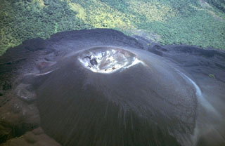 Cerro Negro, Central America's youngest volcano, is a pyroclastic cone that began growing in 1850. It is seen here 130 years later in an aerial view from the NW. The cone rises about 250 m above its base and is surrounded by lava flows that bank up against and are deflected by the slopes of Las Pilas volcano at the top of the photo. More than 20 eruptions, separated by quiet intervals of a few years to a few decades, have taken place in the past century and a half at this small-volume basaltic volcano.
 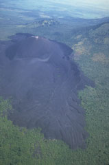 Prominent flow levees are visible on the surface of the 1968 lava flow from Cerro Negro in the foreground, marking individual flow lobes. This flow originated from a spatter cone (named Cristo Rey) on the south flank of Cerro Negro and traveled 1.5 km from the vent. Tephra covers and smooths the surface texture of an older flow in front of the cone to the left; this flow was emplaced during the 1960 eruption.
 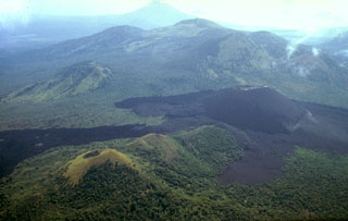 Both the closer part of the compound lava flow extending to the left margin of the photo beyond the vegetated Cerro la Mula cone at the lower left as well as the lighter-colored lava flow directly in front of Cerro Negro were emplaced during a major eruption in 1923. Cerro Negro erupted for seven weeks beginning October 23, 1923. Intense explosive activity increased the height of the cone to 300 m and left a 60-m-wide crater. The broad massif behind Cerro Negro is the Las Pilas complex, and conical Momotombo stratovolcano is in the background to the SE.
 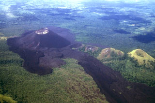 The short dark-colored lava flow in the left foreground and the left-hand, darker flow extending to the lower right-hand margin originated from a vent on the eastern flank of Cerro Negro during a September 4-24, 1957 eruption. In between these flows is an older lighter-colored flow that was erupted in 1947. The long 1957 flow lobe at the lower right overlies a slightly lighter-colored flow to its right that was emplaced in 1923. This view from the NE also shows older vegetated cones including Cerro la Mula, the grassy cone at the extreme right.
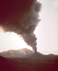 A dark ash-rich column rises above Cerro Negro volcano during the 1968 eruption. The heavy ash cloud was distributed by prevailing winds to the west, darkening the sky in that direction while Las Pilas volcano in the background remains in the sunlight. Ashfall damaged about 700 km2 of croplands.
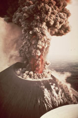 An eruption from Nicaragua's Cerro Negro volcano in 1968 produces an ash plume above the vent. Incandescent ejecta is visible at the base of the column. Gas and steam rise from fumaroles on the righthand side of the scoria cone. Ash and bombs fall from the eruption column at the left.
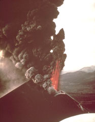 An incandescent lava fountain and a thick ash-laden eruption column rise above the summit crater of Cerro Negro volcano in 1968. Ash columns were distributed primarily to the west, and intense ashfall affected the León-Chinandega area, one of the most densely populated and important agricultural areas in Nicaragua. This aerial view from the SE shows the Telica and San Cristóbal volcanic complexes in the far right distance.
 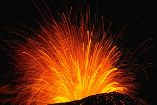 A long-exposure nighttime view of a Strombolian explosion at Cerro Negro volcano in Nicaragua in November 1968. The trajectory of individual incandescent volcanic bombs can be seen radiating from the vent. Hot, incandescent bombs are visible on the outer flanks of the scoria cone.
 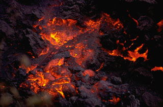 Incandescent lava is visible on the cooling surface of an advancing lava flow from Cerro Negro volcano in 1968. The flow front, which advanced at a rate of about 5 m/hr during the first day of the eruption. The flow originated from a horseshoe-shaped flank vent south of Cerro Negro.
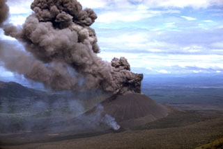 Winds deflect an ash column originating from the summit crater of Cerro Negro in 1968. At the same time a vent on the lower south flank, which is emitting a thin, lighter-colored steam column in this view, fed a lava flow. The advancing flow forms the black lobe extending to the lower left corner of the photo. The 1968 eruption began on October 23 and continued until December 15.
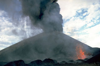 Ash falls at the left from a strombolian eruption column emanating from the summit crater of Cerro Negro volcano in 1968. At the same time incandescent spatter (lower right) is ejected from a small vent on the south flank of the cone. The 1968 eruption began on October 23 and lasted until December 15. The south-flank vent also fed a lava flow that traveled 1.5 km.
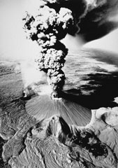 This dramatic photo of Cerro Negro in eruption in November 1968 shows a vigorous vertical ash plume rising from the summit crater. This view from the east also shows the smoking flank vent of Cristo Rey at the southern base of the cone. This vent fed a lava flow that traveled 1.5 km to the SW. Fresh lava flows in the left foreground were erupted in 1960, and those from the prominent east-flank vent (lower center) were erupted in 1957.
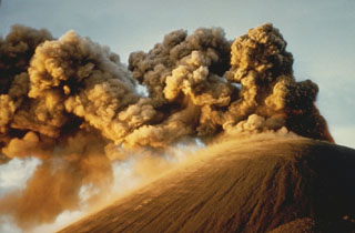 Strong winds deflect ash plumes from a strombolian eruption at the summit crater of Cerro Negro on November 8, 1968. This photo was taken from the south about two weeks after an eruption that began with flank activity on the night of October 23. The following day eruptions began from the summit crater. Plumes rose 1000-1500 meters, and heavy ashfall distributed by winds primarily to the west damaged 700 km2 of croplands. The eruption lasted until December 15.
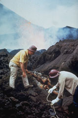 Scientists sample fumaroles near the flank vent at Cerro Negro in November 1968. Incandescent spatter is ejected from the vent in the background behind volcanologist Dick Stoiber (left), who led many expeditions from Dartmouth College to Central American volcanoes. This fumarole was a source of tenorite (CuO) and other minerals.
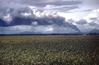 A large tephra cloud silhouetted against weather clouds rises from Cerro Negro volcano in November 1968. Strong winds blowing from the east deflect the ash plume. This view from the SW looks across cotton fields of the Nicaraguan central depression to the Marrabios Range volcanoes. To the right of Cerro Negro is Las Pilas volcano, and the broad massif to the left is Rota volcano.
 The summit crater of Cerro Negro is seen in March 1967, a year and half prior to the 1968 eruption. Light-colored areas result from heavy sublimate deposition. Frequent historical eruptions have greatly modified the morphology of Cerro Negro's summit crater.
  This December 1969 photo shows the crater of Cerro Negro a year after the end of the 1968 eruption. The two craters, separated by a narrow septum, are located north of the summit of the cone. The slopes of Las Pilas volcano are in the background. The morphologies of Cerro Negro's crater and summit have varied dramatically during the course of historical eruptions as a function of the location of the eruptive conduits, vigor of the eruptions, and direction of prevailing winds.
 Volcanologist Bill Rose measures a large bomb ejected during the 1971 eruption of Cerro Negro volcano. The bomb landed on the flank of the cinder cone and rolled across the surface of fresh ash. The 1971 eruption took place February 3-14. Heavy ashfall produced extensive crop damage. This photo was taken in March 1971.
 A geologist surveys the enlarged crater of Cerro Negro volcano in December 1972, observing the effects of the previous eruption during February 3-14, 1971. Powerful explosions substantially enlarged the summit crater from 150 m in diameter before the eruption to 400 m after it. This highly explosive eruption produced ashfall that caused extensive crop damage over a 5000 km2 area.
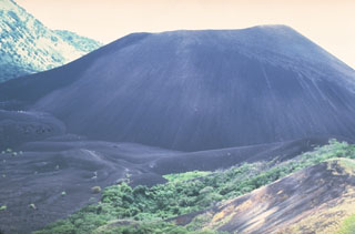 The Cerro Negro scoria cone formed in April 1850. It has been one of Nicaragua's most active volcanoes, building up a roughly 250-m-high cone surrounded by a field of young lava flows. Cerro Negro is seen here in 1981 from Cerro la Mula to the north, the next in a chain of four cinder cones erupted along a N-S line.
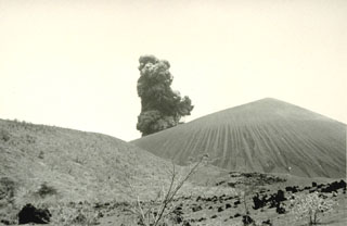 Violent strombolian eruptions 9-14 April 1992 produced heavy ashfall that caused extensive damage to buildings and croplands and forced the evacuation of 28,000 people. This photo shows a small explosive eruption from a vantage point 1 km SE of Cerro Negro during the final day of the 1992 eruption.
 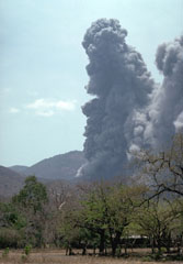 An ash-rich eruption plume rises above Cerro Negro volcano in April 1992. Violent strombolian eruptions during 9-14 April produced heavy ashfall that caused extensive damage to buildings and croplands and forced the evacuation of 28,000 people. Ash clouds reached heights of 7-7.5 km and were distributed to several hundred km distance. The strong explosive eruption enlarged the summit crater to 370 m width.
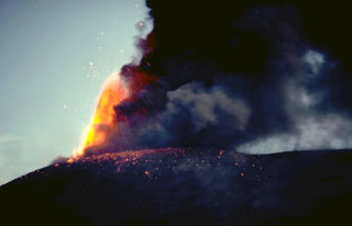 An incandescent lava fountain rises above the summit of Cerro Negro on November 30, 1995, as a plume of dark ash trails off to the right. Explosive eruptions took place from May 28 or 29 until August 16 and then again from November 19 to December 6. Incandescent bombs were ejected to 300-400 m above the rim of the 1992 crater on November 21. The ashfall caused much damage to farmlands.
 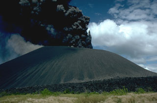 A dark, ash-rich eruption column rises above Cerro Negro volcano on December 1, 1995, near the end of an eruption that began on May 28 or 29. Minor ash eruptions continued intermittently until August 16. A small lava flow appeared in the main crater on July 24. The most intense activity on June 2 was accompanied by a very small pyroclastic surge. Explosive activity resumed from November 19 to December 6, and was accompanied by growth of a small lava dome in the summit crater and lava flows that traveled down the north flank.
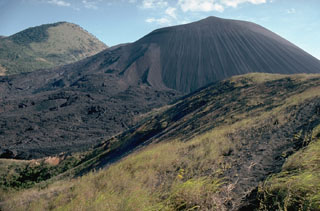 Cerro Negro, the largest and youngest of a group of four cinder cones that were constructed along a N-S line, is Central America's youngest volcano. Since its formation in 1850, Cerro Negro has produced frequent explosive eruptions, building a 250-m-high cinder cone surrounded by a fresh lava field. This 1995 photo from the southernmost of the older cones to the NNE shows flow levees and lava flows at the left side of Cerro Negro that were produced during the 1995 eruption. The vegetated peak in the background is part of the Las Pilas complex.
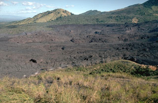 Lava flows from the 1995 eruption of Cerro Negro traveled to the NNE, overtopping earlier flows from eruptions in 1923, 1947, and 1957. The 1995 flows traveled a maximum distance of more than 2 km from a new vent within the 1992 summit crater. The flows mostly were emplaced between November 22 and December 2. They covered an area of 0.65 km2, and individual flow lobes had thicknesses of 2 to 10 meters.
 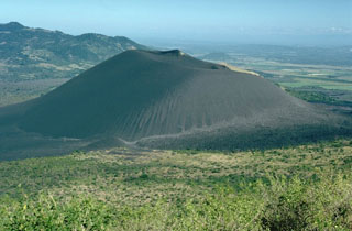 Cerro Negro volcano is viewed here on December 6, 1995, from the SE on the flanks of Las Pilas volcano. The photo was taken on the final day of an eruption that began on May 28 or 29. Minor ash eruptions had continued intermittently until August 16 and resumed November 19 until December 6. The eruption was accompanied by growth of a small lava dome in the summit crater and lava flows that traveled down the north flank
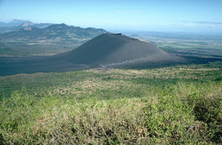 The unvegetated cone of Cerro Negro, the youngest volcano in Nicaragua, is seen here from the slopes of Las Pilas volcano at the end of its 1995 eruption. Lava flows in 1995 traveled to the NNE (right). Beyond Cerro Negro to the NW is the broad massif of Rota volcano. Unlike Telica and San Cristóbal volcanoes in the distance at the far upper left, Rota has had no historical eruptions.
 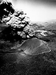 A thick ash column rises from Cerro Negro volcano in November 1968 in this aerial view from the south. A narrow, dark-colored lava flow issues from Cristo Rey, a vent at the SW base of the cone (lower left). The lighter-colored lava flow lobe below and to the right of the cone was erupted during 1960.
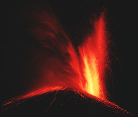 Incandescent ejecta from Cerro Negro volcano rising from a vent at the right reflects off the ash cloud to its left as glowing bombs litter the flanks of the cone. Cerro Negro began erupting on October 23, 1968 both from the summit vent, as seen here, and from a new vent on the south flank that produced a lava flow that traveled 1.5 km. Strong explosive eruptions damaged 700 km2 of cropland before the eruption ended on December 15.
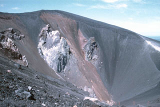 This September 1993 photo shows the morphology of the crater of Cerro Negro volcano after the 1992 eruption. Fumaroles observed during several visits by scientists to Cerro Negro on September 2-5 were issuing from circumferential fractures along the N rim of the crater and from what were interpreted as feeder dikes in the base of the crater. Fumaroles along the crater rim exhibited weak and variable degassing, with temperatures ranging from 79 to 90°C. Stronger fumaroles were confined to the feeder dikes within the crater.
 Cerro Negro, the unvegetated cinder cone at the left center, was born on April 13, 1850 on an uninhabited plain between Las Pilas (in the background) and Rota volcanoes. The new cone reached a height of 50-60 m in ten days, after which activity subsided until renewing on May 27. The tephra-mantled lava flow in the middle of the photo, extending from the western base of the cone to the forest in the foreground, was erupted in 1850. The Las Pilas volcanic complex includes the peaks of Cerro Grande, Las Pilas itself, and Cerro Ojo de Agua.
 The lava flow at the right, partially mantled by tephra, was erupted in July 1947. A strong explosive eruption produced ashfall that damaged crops at Malpaisillo. The 1947 lava flow originated from a parasitic cone and traveled to the NE. This photo from the northern side of Cerro Negro also shows darker-colored lava flows from the 1957 eruption at the extreme right and at the upper left.
 An incandescent eruption column rises above the summit of Cerro Negro in 1971. Major explosive eruptions February 3-14, primarily from the central vent, produced extensive crop damage over a 5000 km2 area and enlarged the summit crater from 150 to 400 m diameter.
  An aerial view from the SW after the 1992 eruption shows the greatly enlarged summit crater. The 1992 eruption expanded the summit crater to 370 m in diameter and an average depth of 90 m. Heavy ashfall caused extensive damage to buildings and croplands. No lava flows were erupted. The lobate lava flow extending to the bottom of the photo was erupted in 1968, and the tephra-mantled flow to its left was emplaced in 1960.
 Street lights burn during daytime as heavy ashfall turns afternoon into night on the streets of León (18 km WSW of Cerro Negro) during an April 1992 eruption. Violent strombolian eruptions during 9-14 April produced heavy ashfall, damaging croplands and forcing the evacuation of 28,000 people. On the evening of 10 April, 15 houses and other structures, including large storage buildings, collapsed in and near León. Collapses of numerous farm buildings, rural homes, and school buildings were reported over the next several days.
 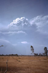 An eruption plume towers above Cerro Negro volcano in this April 1992 view from the south. Violent strombolian eruptions during April 9-14 produced heavy ashfall that caused extensive damage to buildings and croplands. The ash cloud extended 300 km to the WSW, with a maximum width of about 200 km. The eruption column was often clearly visible from Managua (60 km SE). Material ejected to about 7.5 km during more energetic pulses of the eruption was carried roughly 50 km NE by higher-altitude winds.
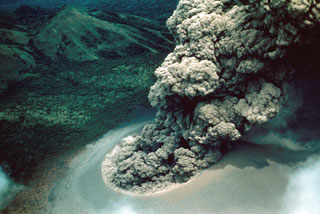 An ash plume rises above Cerro Negro on July 24, 1947. A strong explosive eruption beginning on July 9 produced ashfall that damaged crops at Malpaisillo and prompted evacuations of towns west of the volcano. Ash fell to the Pacific coast and to 7 inches on the roof of the cathedral at Leon. A NE-flank parasitic cone was formed and lava flows were emitted from both summit and flank vents. The eruption lasted until August 2, 1947.
The following 20 samples associated with this volcano can be found in the Smithsonian's NMNH Department of Mineral Sciences collections, and may be availble for research (contact the Rock and Ore Collections Manager). Catalog number links will open a window with more information.
| Catalog Number | Sample Description | Lava Source | Collection Date |
|---|---|---|---|
| NMNH 111217-1 | Pumice | -- | 15 Nov 1968 |
| NMNH 111217-2 | Pumice | -- | 15 Nov 1968 |
| NMNH 111217-3 | Pumice | -- | 15 Nov 1968 |
| NMNH 111217-4 | Pumice | -- | 15 Nov 1968 |
| NMNH 111217-5 | Pumice | -- | 15 Nov 1968 |
| NMNH 111284-1 | Basalt | -- | -- |
| NMNH 111284-2 | Basalt | -- | -- |
| NMNH 116286-1 | Basalt | -- | 3 Aug 1947 |
| NMNH 116286-10 | Volcanic Ash | -- | 25 Jul 1947 |
| NMNH 116286-11A | Volcanic Ash | -- | 25 Jul 1947 |
| NMNH 116286-11B | Volcanic Ash | -- | 25 Jul 1947 |
| NMNH 116286-12 | Glassy Volcanic Bomb | -- | 26 Jul 1947 |
| NMNH 116286-2 | Basalt | -- | 3 Aug 1947 |
| NMNH 116286-3 | Basaltic Volcanic Bomb | -- | 25 Jul 1947 |
| NMNH 116286-4 | Basaltic Volcanic Bomb | -- | 25 Jul 1947 |
| NMNH 116286-5 | Basaltic Volcanic Bomb | -- | 25 Jul 1947 |
| NMNH 116286-6 | Basaltic Volcanic Bomb | -- | 25 Jul 1947 |
| NMNH 116286-7 | Volcanic Rock | -- | 25 Jul 1947 |
| NMNH 116286-8 | Basaltic Volcanic Bomb | -- | 25 Jul 1947 |
| NMNH 116286-9 | Volcanic Ash | -- | 25 Jul 1947 |
| Copernicus Browser | The Copernicus Browser replaced the Sentinel Hub Playground browser in 2023, to provide access to Earth observation archives from the Copernicus Data Space Ecosystem, the main distribution platform for data from the EU Copernicus missions. |
| MIROVA | Middle InfraRed Observation of Volcanic Activity (MIROVA) is a near real time volcanic hot-spot detection system based on the analysis of MODIS (Moderate Resolution Imaging Spectroradiometer) data. In particular, MIROVA uses the Middle InfraRed Radiation (MIR), measured over target volcanoes, in order to detect, locate and measure the heat radiation sourced from volcanic activity. |
| MODVOLC Thermal Alerts | Using infrared satellite Moderate Resolution Imaging Spectroradiometer (MODIS) data, scientists at the Hawai'i Institute of Geophysics and Planetology, University of Hawai'i, developed an automated system called MODVOLC to map thermal hot-spots in near real time. For each MODIS image, the algorithm automatically scans each 1 km pixel within it to check for high-temperature hot-spots. When one is found the date, time, location, and intensity are recorded. MODIS looks at every square km of the Earth every 48 hours, once during the day and once during the night, and the presence of two MODIS sensors in space allows at least four hot-spot observations every two days. Each day updated global maps are compiled to display the locations of all hot spots detected in the previous 24 hours. There is a drop-down list with volcano names which allow users to 'zoom-in' and examine the distribution of hot-spots at a variety of spatial scales. |
|
WOVOdat
Single Volcano View Temporal Evolution of Unrest Side by Side Volcanoes |
WOVOdat is a database of volcanic unrest; instrumentally and visually recorded changes in seismicity, ground deformation, gas emission, and other parameters from their normal baselines. It is sponsored by the World Organization of Volcano Observatories (WOVO) and presently hosted at the Earth Observatory of Singapore.
GVMID Data on Volcano Monitoring Infrastructure The Global Volcano Monitoring Infrastructure Database GVMID, is aimed at documenting and improving capabilities of volcano monitoring from the ground and space. GVMID should provide a snapshot and baseline view of the techniques and instrumentation that are in place at various volcanoes, which can be use by volcano observatories as reference to setup new monitoring system or improving networks at a specific volcano. These data will allow identification of what monitoring gaps exist, which can be then targeted by remote sensing infrastructure and future instrument deployments. |
| Volcanic Hazard Maps | The IAVCEI Commission on Volcanic Hazards and Risk has a Volcanic Hazard Maps database designed to serve as a resource for hazard mappers (or other interested parties) to explore how common issues in hazard map development have been addressed at different volcanoes, in different countries, for different hazards, and for different intended audiences. In addition to the comprehensive, searchable Volcanic Hazard Maps Database, this website contains information about diversity of volcanic hazard maps, illustrated using examples from the database. This site is for educational purposes related to volcanic hazard maps. Hazard maps found on this website should not be used for emergency purposes. For the most recent, official hazard map for a particular volcano, please seek out the proper institutional authorities on the matter. |
| IRIS seismic stations/networks | Incorporated Research Institutions for Seismology (IRIS) Data Services map showing the location of seismic stations from all available networks (permanent or temporary) within a radius of 0.18° (about 20 km at mid-latitudes) from the given location of Cerro Negro. Users can customize a variety of filters and options in the left panel. Note that if there are no stations are known the map will default to show the entire world with a "No data matched request" error notice. |
| UNAVCO GPS/GNSS stations | Geodetic Data Services map from UNAVCO showing the location of GPS/GNSS stations from all available networks (permanent or temporary) within a radius of 20 km from the given location of Cerro Negro. Users can customize the data search based on station or network names, location, and time window. Requires Adobe Flash Player. |
| DECADE Data | The DECADE portal, still in the developmental stage, serves as an example of the proposed interoperability between The Smithsonian Institution's Global Volcanism Program, the Mapping Gas Emissions (MaGa) Database, and the EarthChem Geochemical Portal. The Deep Earth Carbon Degassing (DECADE) initiative seeks to use new and established technologies to determine accurate global fluxes of volcanic CO2 to the atmosphere, but installing CO2 monitoring networks on 20 of the world's 150 most actively degassing volcanoes. The group uses related laboratory-based studies (direct gas sampling and analysis, melt inclusions) to provide new data for direct degassing of deep earth carbon to the atmosphere. |
| Large Eruptions of Cerro Negro | Information about large Quaternary eruptions (VEI >= 4) is cataloged in the Large Magnitude Explosive Volcanic Eruptions (LaMEVE) database of the Volcano Global Risk Identification and Analysis Project (VOGRIPA). |
| EarthChem | EarthChem develops and maintains databases, software, and services that support the preservation, discovery, access and analysis of geochemical data, and facilitate their integration with the broad array of other available earth science parameters. EarthChem is operated by a joint team of disciplinary scientists, data scientists, data managers and information technology developers who are part of the NSF-funded data facility Integrated Earth Data Applications (IEDA). IEDA is a collaborative effort of EarthChem and the Marine Geoscience Data System (MGDS). |

