
OVSICORI-UNA reported that Irazú’s seismic network recorded a significant landslide in the W part of the volcano on 4 November along with a lahar. A small thermal anomaly was detected in MODIS (Moderate Resolution Imaging Spectroradiometer) satellite data.
Source: Observatorio Vulcanologico y Sismologico de Costa Rica-Universidad Nacional (OVSICORI-UNA)
Crater lake dries and regional acid-rain report
In April 2010 the lake within Irazú's crater dwindled to only a few centimeters depth and from May to August the lake was dry enough to allow plants to grow up to 10 cm high. Water began to accumulate in September 2010 but disappeared again during the following month. Since November 2010 water returned to the crater and as late as April 2011, a shallow turquoise-blue lake was maintained. Continuous monitoring of acid rain on Irazú's flanks reflected contributions from Turrialba. Often called Irazú's "twin volcano," Turrialba is less than 10 km to the ENE and during the past 4 years it has caused a region-wide increase in acid rain. Covering January 2004 through September 2007, the last Bulletin report on Irazú (BGVN 32:11) highlighted decreasing lake levels, fumarolic changes, and minor mass wasting on the crater walls during January 2004 to March 2007 (see table 8 for a summary of lake changes).
Table 8. Changing lake conditions based on observations of Irazú's crater. Double asterisks indicate times when the lake disappeared; "--" fills cells where no data is available; lake levels are reported qualitatively except for the 7 October to 12 March 2010 time interval when absolute values were measured. This summary is based on ICE data and OVSICORI Monthly Reports.
| Date | Lake level | Temp. °C | Water color | Notes |
| ** Apr 1990 | Empty | -- | -- | -- |
| 1991-1994 | Stable | -- | green | Infrequent Bubbles |
| 08 Dec 1994 | ~VEI 2 explosion from the NW outer flank fumarole~ | -- | -- | -- |
| 1994-1996 | Stable | -- | green | Bubbles |
| May 2000 | Decreasing | 18 | yellow-green | Bubbles |
| Jan 2001 | ~30 | -- | green | Bubbles |
| 08 Feb 2003 | Stable | 15 | reddish | Rockslide into lake |
| Jan-Dec 2004 | Stable | -- | green | Convection cells at edges |
| Jan-Nov 2005 | Stable | -- | green | Convection cells in center |
| Mar-Dec 2006 | Stable | -- | increasingly yellow-green | Convection cells in various locations |
| Mar-Sep 2007 | Decreasing | 145 | light-green | Convection cells at edges and center; bubbles |
| 20 Sep 2007-Mar 2008 | Decreasing | 17 | -- | Bubbles |
| 05 Mar 2008-07 Oct 2009 | Decreasing | 14 | dark green | Bubbles |
| 07 Oct 2009-12 Mar 2010 | 1.4 m | 16 | dark-to-light green | -- |
| Apr 2010 | Only few cm | -- | -- | -- |
| ** May-Aug 2010 | Empty | -- | -- | Plants on crater floor |
| Sep 2010 | Re-forming | -- | -- | -- |
| ** Oct 2010 | Empty | -- | -- | -- |
| Nov 2010-Jan 2011 | Forming | -- | turquoise | -- |
| Feb-Apr 2011 | Few meters | -- | turquoise-to-blue | -- |
On 22 July 2010 a team of investigators from Observatorio Vulcanologico Sismologica de Costa Rica-Universidad Nacional (OVSICORI-UNA) descended to the dry crater floor. They documented changes in vegetation, fumaroles, and clay deposition on the crater floor. Photos taken during prior trips provided comparisons with previous conditions (figure 14). Rockfalls and minor mass wasting had been occurring regularly and the long runout of debris across the crater floor was visible during this investigation. Most of the debris fell from the E and SW walls. On the NE side of the dry crater a rocky area emitted low temperature (24°C) sulfur-smelling gases from three aligned vents. Higher temperatures (86°C) were measured from fumaroles on the N side of the crater but they appeared to be releasing gas with less energy than observed in the past years when bubbles were visible within the lake. Another interesting finding was a waterfall on the inside of the crater on the SW wall; this small waterfall did not have sufficient volume to pool on the crater floor and instead soaked directly into the surrounding clay.
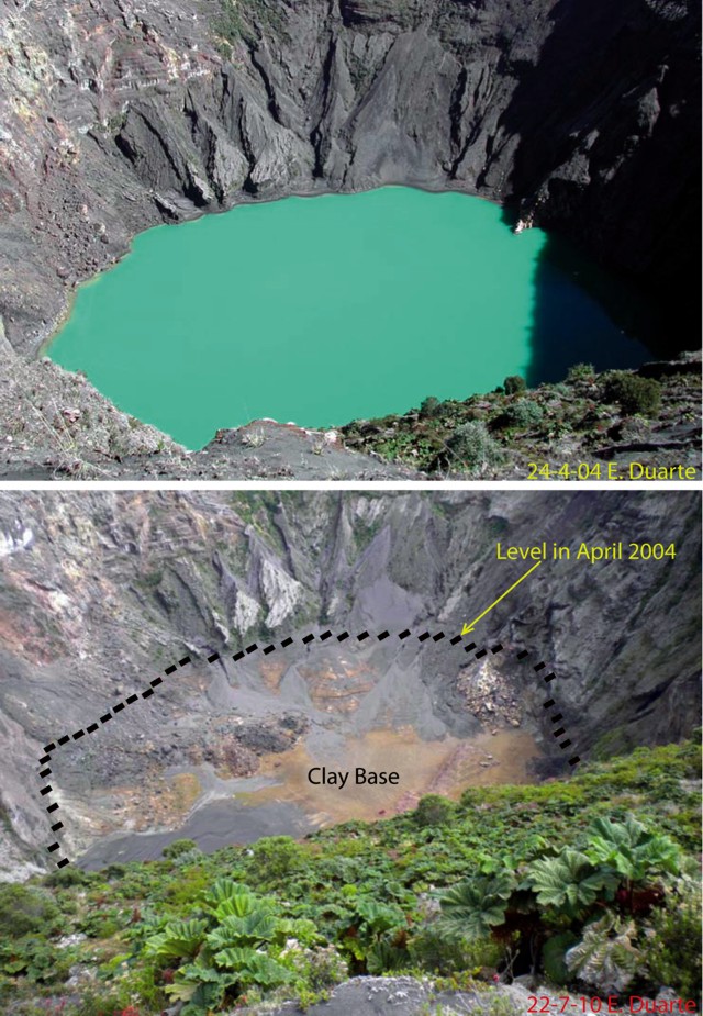 |
Figure 14. Views taken from Irazú's S rim. (top) The crater on 24 April 2004 contained a turquoise lake. (bottom) A repeat photo taken on 22 July 2010 shows the lake had disappeared; the former lake level and the clay base on the crater floor are marked. Since November 2010 water had accumulated and as of April 2011, was several meters deep. Courtesy of Eliecer Duarte, OVSICORI-UNA. |
The water level in Irazú's crater has been variable throughout time; the Bulletin recorded a dry crater during February 1977 and June 1987 (SEAN 12:07), and April 1990 (BGVN 15:04). Factors highlighted during the IAVCEI CVL-7 ("Commission of Volcanic Lakes" Costa Rica, 10-19 March 2010) included complex connections with Turrialba, seasonal effects, infiltration within the crater, and the role of mass wasting. The mechanism for the recent disappearance of the lake is still under investigation by OVSICORI-UNA and ICE investigators (Guillermo Alvarado, personal communication).
Erosion. Mass wasting had been an ongoing process for at least 10 years. Material is primarily shed from the E and SW walls and the lake contained islands of black and red material formed from the debris. In February 2003 a major rockslide into the lake caused the water color to change from green to shades of red. An analysis of seismicity during that month showed no correlation to these slope failures (BGVN 28:12). Cracks along the NW rim formed and widened since December 2007; these cracks caused blocks up to 3 x 20 m to fall from the rim in March 2008.
Local gas measurements. Since the large phreatic explosion in December 1994 (BGVN 19:12), the NW fumarole has been releasing low gas emissions regularly. Different temperature measurements recorded since June 2010 ranged between 90°C to 86°C. To monitor changes in sulfur dioxide output from Irazú, a network of three stations collected rain samples from sites along the volcano's flanks.
The pH data from September 2004 through July 2010 were plotted in the OVSICORI-UNA July 2010 monthly report. The results correlate pH changes to much larger degassing events occurring at Turrialba, a neighboring volcano that began major degassing in 2007. Only the "Borde Sur" station was sampling continuously but the other two stations reflected similar trends in acidity. Despite irregular fluctuations, a decreasing pH trend began in 2007. The lowest point of the trend was measured by "Borde Este" at approximately pH 3.25. Where there "Pacayas" station data began, the trend appeared to have stabilized between pH 3.25 and 4.75.
References. D. Rouwet, R.A. Mora-Amador, C.J. Ramírez-Umaña, G. González, Seepage of "aggressive" fluids reduce volcano flank stability: the Irazú and Turrialba case, Costa Rica, Abstract, CVL 7 Workshop Costa Rica, IAVCEI-Commission of Volcanic Lakes, March 2010.
Information Contacts: E. Duarte, Observatorio Vulcanologico Sismologica de Costa Rica-Universidad Nacional (OVSICORI-UNA), Apartado 86-3000, Heredia, Costa Rica (URL: http://www.ovsicori.una.ac.cr/); G. Alvarado and G.J. Soto, Oficina de Sismologia y Vulcanologia del Arenal y Miravalles (OSIVAM), Instituto Costarricense de Electricidad (ICE), Apartado 10032-1000, San Jose, Costa Rica.
2020: April
| July
| August
| November
OVSICORI-UNA reported that Irazú’s seismic network recorded a significant landslide in the W part of the volcano on 4 November along with a lahar. A small thermal anomaly was detected in MODIS (Moderate Resolution Imaging Spectroradiometer) satellite data.
Source: Observatorio Vulcanologico y Sismologico de Costa Rica-Universidad Nacional (OVSICORI-UNA)
OVSICORI-UNA reported that Irazú’s seismic network recorded land movement 1.2 km SW of the SW crater rim in a high area used for radio and television antennas. Landslides in the area had been observed since 2014, but activity accelerated in the previous months. The number of events indicating landslides began to exponentially increase particularly after 20 August. The rate of movement had increased to 20 m/year horizontally and about 25 m/year vertically by 24 August; movement of more than 20 cm was recorded during 23-24 August. A large block collapsed to the NW, into the Rio Sucio drainage, during the morning of 26 August.
Source: Observatorio Vulcanologico y Sismologico de Costa Rica-Universidad Nacional (OVSICORI-UNA)
OVSICORI-UNA reported that at 2138 on 12 July the seismic network at Irazú recorded a significant landslide, possibly in the N part of the crater. The event could not be confirmed because of weather conditions. Another landslide event was recorded at 1538 on 13 July, which again could not be visually confirmed.
Source: Observatorio Vulcanologico y Sismologico de Costa Rica-Universidad Nacional (OVSICORI-UNA)
OVSICORI-UNA reported that on 21 April scientists confirmed that the lake in Irazú’s crater was gone and noted continuous intra-crater landslides from unstable parts of the crater.
Source: Observatorio Vulcanologico y Sismologico de Costa Rica-Universidad Nacional (OVSICORI-UNA)
Reports are organized chronologically and indexed below by Month/Year (Publication Volume:Number), and include a one-line summary. Click on the index link or scroll down to read the reports.
Low-temperature gases collected
Between 14 June and 11 July, personnel from PIRPSEV, CNRS, and the volcano observation section of IPG sampled gases from five Central American volcanoes. Low-temperature gases were collected at Turrialba and Irazú.
Information Contacts: H. Delorme, Univ. de Paris; J.L. Cheminée, IPG, Paris.
No activity observed
"The summit was visited on 19 November and 5 December. No activity was observed [but see 7:5 and 7:11]."
Information Contacts: R. Stoiber, S. Williams, H.R. Naslund, J.B. Gemmell, D. Sussman, Dartmouth College; D. Fajardo, Instituto de Investígaciones Sismicas, Nicaragua; E. Malavassi R. and J. Barquero H., Univ. Nacional, Heredia.
Fumarolic activity on the NW flank
Fumarolic activity continued on the NW flank, where temperatures varied between 70° and 90°C in March. No activity was observed in the main crater.
Information Contacts: J. Barquero H., Univ. Nacional, Heredia.
Sulfur odors now always detectable in the summit region
"Some indications that Irazú may be becoming more active were noted in several trips to the summit. The smell of H2S, only occasionally noticeable in November-December 1981 and again in January 1982, was always detectable in the summit region. On 22 November a small flow of molten sulfur was observed to have advanced several meters from a fumarole at the base of the N wall of the active crater. Park guards believed that it was new that day.
"Faulting and slumping of scarps were reported to have occurred over a large area of the summit during November. This was largely confined to a belt oriented NE-SW and ~3-4 km from the summit crater. Park guards reported a single day in September in which 20-30 earthquakes were felt."
Information Contacts: R. Stoiber, S. Williams, H.R. Naslund, C. Connor, J. Prosser, and J.B. Gemmell, Dartmouth College; E. Malavassi R. and J. Barquero H., Univ. Nacional, Heredia.
Fumarolic activity on the NW flank
Fumarolic activity was limited to the NW flank of the volcano. Temperatures oscillated between 78°C and 85°C. No activity was observed in either the principal crater or Diego de la Haya, just to the SE.
Activity on a local fault caused an earthquake swarm 4 June. The swarm generated landslides in the wall that divides the principal crater from Diego de la Haya. Another stronger swarm occurred 23-24 September affecting the area between Irazú and Turrialba volcano.
Information Contacts: R. Stoiber, S. Williams, R. Naslund, C. Connor, J. Prosser, and J. Gemmell, Dartmouth College; E. Fernández S. and J. Barquero H., Univ. Nacional, Heredia.
Temperature and gas data
The low temperatures measured in 1982 do not vary from the results of June 1981. Between 5 December and 20 December 1982, a team from PIRPSEV (CNRS) and a volcanological team from the Universidad Nacional de Costa Rica sampled gases from Irazú (table 1).
Table 1. Average values of gas compositions collected between 5 and 20 December 1982 compared to earlier data.
| Year | SO2% | CO2% | H2% | H2S% | CO% | CH4% | He (ppm) |
| 1981 | 0.106 | 98.02 | 0.015 | 1.860 | 0.003 | 0 | 8.4 |
| 1982 | 0.007 | 99.8 | 0 | 0.119 | 0.002 | 0 | 6.0 |
Information Contacts: J. Cheminée, IPG, Paris; M. Javoy and H. Delorme, Univ. de Paris.
Fumarolic activity on the NW flank
Fumarolic activity continued on the NW flank, where temperatures oscillated between 74 and 81°C. The main crater and Diego de la Haya crater remained inactive.
Information Contacts: J. Barquero H. and J. de Dios Segura, Univ. Nacional, Heredia.
Fumarolic activity
Fumarolic activity continued on the NW flank with a mean temperature of 77°C. No activity was observed in the craters.
Information Contacts: J. Barquero H. and E. Fernández S., Univ. Nacional, Heredia.
Gas emission
Fumarolic activity continued on the N flank, with temperatures averaging about 60°C. A lake that started to form in the main crater in September 1984 was still present in July 1985. Bubbles from the gas emission could be seen rising through the lake water.
Information Contacts: J. Barquero H. and E. Fernández S., Univ. Nacional, Heredia.
Crater lake drains
The rainwater lake in the main (inactive) crater was reported to have disappeared, probably during June 1987. The same phenomenon was observed in February 1977 and was assumed by observers to have resulted from water drainage through a fracture.
Information Contacts: R. Barquero and Guillermo Alvarado, ICE.
Flank fumarolic activity from two craters
Fumarolic activity continued on the NW flank, with temperatures of 80°C. The crater lake that had formed in 1984 disappeared in June, probably by water drainage.
Information Contacts: J. Barquero, OVSICORI.
Fumarolic activity continues; rain forms two crater lakes
For the past several years, fumarolic activity on the NW flank has continued unchanged. Because of intense precipitation during August and September, small greenish lakes have recently formed in the main crater and Diego de la Haya crater. No signs of solfataric degassing have been observed in the lakes.
Information Contacts: G. Soto, Escuela Centroamericana de Geologia & Red Sismologica Nacional, Univ de Costa Rica.
Solfataric activity
During fieldwork in June, Irazú remained quiet. Activity was limited to low-temperature solfataras on the NW flank. There was a small emerald green lake in the main crater, active in the 1963-65 explosive eruption.
Information Contacts: G. Soto, Escuela Centroamericana de Geologia & Red Sismologica Nacional, Univ de Costa Rica.
Crater lake gone; flank fumarolic activity
Fumarolic activity continued on the NE flank, with a mean temperature of 89°C. The lake in the main crater had disappeared. Small landslides persisted on the W and N crater walls.
Information Contacts: J. Barquero, OVSICORI.
Low-temperature fumarolic activity; small landslides
Low-temperature fumarolic activity (average temperature 90°C) continued. During July, there were small landslides down the wall separating the active crater and Diego de la Haya crater. An earthquake, centered 1 km NW of the active crater, occurred on 24 August.
Information Contacts: J. Barquero, OVSICORI.
Nearby seismic swarm apparently tectonic; surface activity unchanged
A seismic swarm, centered between San Juan de Chicuá and the summit (figure 1), began on 2 January and continued through the end of the month. Two peaks in swarm activity occurred, the first on 7 January when 95 events were recorded, and the second on 27 January with 103 events (figure 2); 700 were recorded during the month. Seismicity increased towards the end of January, with maximum magnitudes of 4.0 (table 2) and intensities of MM III-IV. Several of the shocks were felt by area residents.
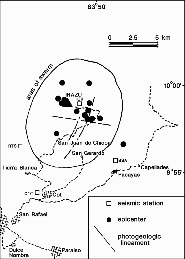 |
Figure 1. Epicenters of earthquakes recorded during the January 1991 seismic swarm at Irazú. Courtesy of Gerardo Soto. |
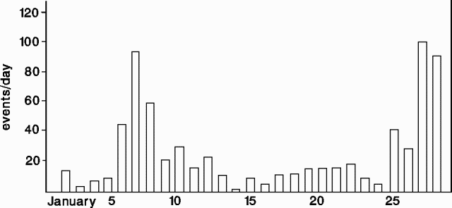 |
Figure 2. Daily number of earthquakes at Irazú, January 1991. Courtesy of Gerardo Soto. |
Table 2. Strongest events during the earthquake swarm at Irazú, January 1991.
| Date | Time | Magnitude |
| 07 Jan 1991 | 1011 | 2.1 |
| 07 Jan 1991 | 1013 | 2.1 |
| 07 Jan 1991 | 1234 | 2.5 |
| 07 Jan 1991 | 1352 | 2.7 |
| 08 Jan 1991 | 0407 | 3.3 |
| 13 Jan 1991 | 1017 | 3.5 |
| 16 Jan 1991 | 0708 | 3.8 |
| 16 Jan 1991 | 0748 | 2.0 |
| 27 Jan 1991 | 0117 | 3.2 |
| 27 Jan 1991 | 0258 | 3.3 |
| 27 Jan 1991 | 1049 | 3.4 |
| 27 Jan 1991 | 1109 | 3.6 |
| 27 Jan 1991 | 2109 | 3.8 |
Seismologists determined that the earthquakes were tectonic in origin and occurred at very shallow depth. No morphologic changes were noted at the volcano and fumarolic activity appeared to be similar to previous years. Seismic swarms had previously been recorded at Irazú in 1982 and 1987, although normal seismic activity is very low. Scientists noted that the shocks may be related to a fault SSE of the volcano, perhaps activated by the major earthquake [M 5.7] that occurred near Puriscal [50 km WSW] on 22 December.
Information Contacts: G. Soto and R. Barquero, ICE; Mario Fernández and Wilfredo Rojas, Escuela Centroamericana de Geología, Univ de Costa Rica.
Seismicity declines
The seismic swarm that began 2 January continued through late February, but seismicity decreased to three small recorded events daily by the end of the month.
Information Contacts: R. Barquero, ICE; Mario Fernández, Escuela Centroamericana de Geología, Univ de Costa Rica.
Tectonic earthquake swarm
A large swarm of tectonic earthquakes was recorded just S of the crater from 2 January through the end of February. On 25 May, a rapid increase in the number of tectonic earthquakes marked the start of a second swarm in the same zone. A shock located about 1 km E of the crater was felt on 28 May (M 3.5), and two others centered near the crater were felt on 5 June at 0534 (M 3.5) and 0540 (M 3.2). Scientists believe that the seismicity may represent reactivation of the fault zone involved in the M [7.6] earthquake that occurred about 90 km ESE on 22 April. No changes in surface activity at the volcano were reported.
Information Contacts: R. Barquero, ICE; Mario Fernández, Red Sismológica Nacional (RSN), Univ de Costa Rica; ACAN news service, Panamá City, Panamá.
Tectonic earthquake swarm; new fumaroles but temperatures remain <100°C
A swarm of tectonic earthquakes, centered near the summit at 0-8 km depth, began in late May (16:05) and continued through June. The swarm followed aftershocks of the 22 April earthquake (16:05), and has been interpreted as representing reactivation of a fault zone. A similar earthquake swarm in January (16:1-2) was interpreted as fault reactivation caused by an [M 5.7] earthquake on 22 December [50 km WSW] of Irazú.
During the second week of June, a group of new fumaroles formed in the NE, N, NW, and S parts of the crater. Temperatures of up to 94°C were measured during fieldwork the next week, similar to NW-flank fumarole temperatures (80-90°C) since 1965. Temperatures and activity at other fumaroles remained unchanged. The seasonal crater lake, which began to fill the last week of June, remained at ambient temperature except around fumaroles, where the water was 30-48°C and had a pH of 5.9 (similar to pH measurements in 1986 and 1987). Small landslides occurred down the E, NE, and SW crater walls. Deformation measurements indicated no significant changes.
Several small tremor episodes (durations <=60 seconds) and low-frequency events were recorded during June. Univ Nacional scientists suggested that the tremor could be related to shallow hydrothermal activity and degassing beneath the crater.
Information Contacts: J. Barquero, E. Fernández, V. Barboza, R. Van der Laat, and E. Malavassi, OVSICORI; R. Barquero, Guillermo Alvarado, Mario Fernández, Hector Flores, and Sergio Paniagua, ICE.
Seismicity remains high; crater lake level rises
In July, the turquoise-green crater lake continued to rise, eventually covering 2/3 of the crater floor, including several fumaroles that formed during early-mid June. Sulfur deposits had been observed at some of these fumaroles. On 17 July, the lake was 150 x 100 m, with a maximum depth of 2 m. Water temperatures increased with proximity to the bubbling springs (90°C), mud pots, and roaring fumaroles, ranging from 35°C to 55°C (compared to 30-48°C in late June). The lake had pH of 3.7.
Seismicity remained at high levels in July, but was decreased in comparison to late May-June (16:5-6). July's highest seismicity occurred on the 4th, when 75 earthquakes were recorded (seismic station IRZ2, 5 km WSW, Univ Nacional network; figure 3), 34 of which occurred in a NW-SE trend. The 4 July earthquakes (M 1.5-2.7) were centered 0.6-10 km from the crater at <10 km depth. Tremor episodes and B-type earthquakes continued to be recorded in July.
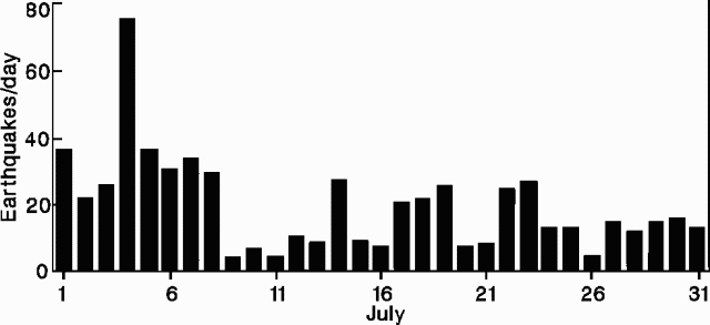 |
Figure 3. Daily number of earthquakes at Irazú, July 1991. Courtesy of Universidad Nacional. |
Information Contacts: R. Barquero, Guillermo Alvarado, and Alain Creussot, ICE; Mario Fernández and Hector Flores, Sección de Sismología y Vulcanología, Univ de Costa Rica; J. Barquero, E. Fernández, V. Barboza, and J. Brenes, OVSICORI.
New fumaroles but seismicity declines
Fumarolic activity continued in August, mainly in a large zone of sulfur and chloride deposition in the N section of the crater, while a new zone of fumarolic activity appeared in the SSE part. The crater lake grew to cover almost the entire floor, >150 m in diameter. Seismicity, abnormally high since late May, continued to decrease in August (figure 4). During the second week in June, a new group of fumaroles appeared in the crater.
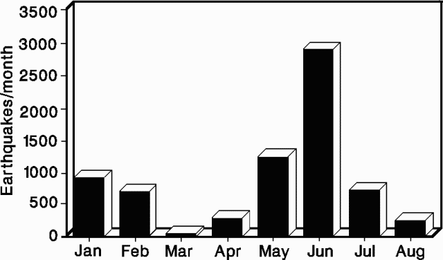 |
Figure 4. Monthly number of earthquakes at Irazú, January-August 1991. Courtesy of the Instituto Costarricense de Electricidad. |
Information Contacts: R. Barquero and G. Soto, ICE; Mario Fernández, Hector Flores, and Sergio Paniagua, Sección de Sismología y Vulcanología, Univ de Costa Rica.
Continued fumarolic activity and seismicity; crater lake rises
Crater fumarolic activity continued in September, with the most intense emissions in the N and NW sections, where distinct gas vents were visible. Gas temperatures were 90°C and condensates had a pH of 3.5. One fumarole produced a roaring sound audible at the summit rim overlook. The level of the turquoise-green crater lake continued to rise; numerous fumaroles were drowned but continued emitting subaqueously. The average lake temperature was 37°C (compared to 35°C in July), with a temperature of 90°C measured near active fumaroles in the N part of the lake. Weaker fumarolic activity occurred in the SE, E, and NE parts of the lake, and on the crater's E slope. In September, 74 earthquakes (M 1-2) were recorded, with depths <8 km.
Information Contacts: J. Barquero, E. Fernández, V. Barboza, and J. Brenes, OVSICORI.
Fumarole temperatures and seismicity decline
Fumarolic activity continued within the crater through October, with no significant changes, although there was an apparent slight temperature decrease from 90.0-91.6°C in September, to 83.8-90.4°C in October. The hottest and most vigorous fumarole was located in an alluvial fan on the crater's N side. Crater lake level increased in September, and stabilized through October at a maximum depth of 14 m. Small fluctuations were noted, corresponding with rainfall. Seismicity continued to decline in September, reaching very low levels in October.
Information Contacts: R. Barquero and G. Soto, ICE.
Fumarolic activity declines
The turquoise-green crater lake continued to rise in November. Fumarolic activity, concentrated in the N part of the crater, diminished considerably, and stopped entirely at some sites. Some submerged fumaroles persisted subaqueously. A fumarole in the NW part of the crater had a temperature of 90°C and a condensate pH of 3.5, both similar to measurements during the previous 2 months.
Information Contacts: E. Fernández and J. Barquero, OVSICORI.
Fumarolic activity; crater lake rises
Fieldwork on 19 November showed continued fumarolic activity at the base of the main crater, with temperatures of 90°C, similar to those of previous months. The crater lake had an average temperature of 26.7°C, and a pH of 3.0 (compared to 3.5 in September). Water level had risen 40 cm since October, and the lake radius had grown 5 m. The color of the lake had changed, probably from sediment input. Many subaqueous fumaroles were observed. The summit station (ICR) recorded 36 microearthquakes during November, a decline from the high rates during seismic swarms several months earlier.
Information Contacts: G. Soto, R. Barquero, and Mario Fernández, ICE.
Crater lake shrinks; activity stops at some fumaroles but continues at others
The water level in the main crater lake fell in January, following a rise of 1 m associated with heavy rains at the end of November. Although subaqueous and subaerial fumarolic activity continued unchanged along the N edge of the lake and crater wall, subaqueous fumaroles disappeared in the NE and SW parts of the lake in December. Fresh deposits from small landslides were observed on the NE and SW crater walls. A sulfur odor was strong on the SW crater rim, and vegetation S of the crater was partly "burned," probably due to acid rain and cold weather. Seismicity in January was at low levels, similar to December, with monthly totals of 29 low-frequency and 5 high-frequency earthquakes (recorded by OVSICORI).
Information Contacts: E. Fernández, V. Barboza, and J. Barquero, OVSICORI; G. Soto and R. Barquero, ICE.
Fumarolic activity in and around crater lake; continued seismicity; deflation
Fumarolic activity continued in February. Although the water level continued to drop, the crater lake remained larger than it had been in November (figure 5 and table 3). Water temperatures (measured by UNA) on the N side of the lake near the most active subaqueous fumaroles ranged from 37°C to 73°C; bubbling springs near the edge of the lake were
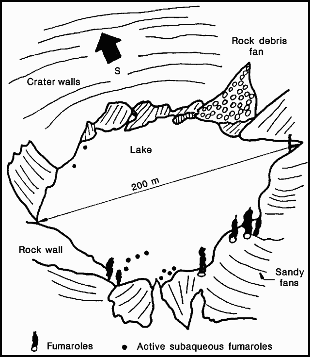 |
Figure 5. Oblique view of the crater lake at Irazú, 25 February 1992. Courtesy of ICE. |
Table 3. Crater lake characteristics at Irazú, November 1991 and February 1992. Courtesy of ICE.
| Date | Diameter | Max. Depth | Est. Volume | Avg. Temp. | Min. pH |
| 19 Nov 1991 | 195 m | 14.35 m | 280,000 m3 | 26.7°C | 2.85 |
| 12 Feb 1992 | 202 m | 15.25 m | 330,000 m3 | 28.3°C | 3.23 |
A monthly total of 234 earthquakes was recorded in February (at UNA station IRZ2, 5 km WSW of the crater), with a maximum of 37 on 21 February. Nine high-frequency earthquakes were recorded in February. Measurements of two geodetic lines across the summit on 13 February indicated contractions of 6.4 ppm in an E-W direction and 15.8 ppm in a N-S direction, since 10 October 1991 (UNA).
Information Contacts: E. Fernández, J. Barquero, V. Barboza, and R. Van der Laat, OVSICORI; G. Soto and R. Barquero, ICE.
Earthquakes in three epicentral zones; fumarolic activity
Fumarolic activity continued in March. The crater lake's water level was several centimeters lower than in February, with an average temperature of 28°C and a pH of 3.7 on 2 April. The 141 earthquakes recorded in March (at station IRZ2, 5 km W of the crater), included M 2.0-2.5 events on 2, 15, and 21-22 March. The larger earthquakes were centered 6-7 km NW, 1.5 km SE, and 3 km NE of the crater, at 0-17 km depth. Low-frequency seismicity continued beneath the crater.
Information Contacts: E. Fernández, J. Barquero, and V. Barboza, OVSICORI; G. Soto and R. Barquero, ICE; Guillermo Alvarado, GEOMAR, Christian-Albrechts-Universität, Germany; Mario Fernández, Sección de Sismología y Vulcanología, Escuela Centroamericana de Geología, Univ de Costa Rica.
Continued fumarolic activity; crater lake shrinks
The main crater's fumarolic activity continued in April. Although temperatures remained similar at 88-91.5°C, the jet-engine sound heard in prior months was no longer audible. Between 12 February and 2 April, the crater lake's water level dropped 16 cm and the lake diameter shrank by 2 m. Cold and warm springs around the volcano showed no measurable changes in temperature or pH. The portable seismic net continued to record low-frequency earthquakes of low energy. Fewer than 10 events were recorded in April (at station "ICR", near the summit).
Information Contacts: G. Soto and R. Barquero, ICE.
Fumarolic activity in and around crater lake; low-frequency seismicity
During May, water in the crater lake returned to the level of the previous summer. Fumarolic emissions N of the lake decreased, while subaqueous fumaroles in the SE, E, and N parts of the lakes remained active. Small landslides occurred along the crater's E, N, and SW walls. A monthly total of 126 earthquakes was recorded (at station IRZ2, 5 km W of the crater), with a M 1.8 event centered 3.6 km SW of the crater, at 1 km depth, on 5 May. Low-frequency seismicity continued through May.
Information Contacts: E. Fernández, J. Barquero, and V. Barboza, OVSICORI.
Fumarolic activity and seismicity continue
Fumarolic activity continued in the main crater. Its lime-green lake had a mean temperature of 28°C and a minimum pH of 4.9 on 3 June. Fumaroles persisted in the area NE of the lake, with temperatures of 84-90°C. Areas of bubbling to the NE remained vigorous, with strong emission of cold gas, perhaps CO2. Hot bubbling areas were stable at temperatures <=91°C. Fumarolic vents in the sedimentary fan N of the lake were buried by new sedimentation triggered by heavy rains. The resulting zone of steaming ground had surface temperatures of up to 90°C.
Seismicity continued, with 48 events recorded during June at a station (ICR) 2.2 km E of the active crater and 36 low-frequency microseisms registered 5 km WSW of the crater (at station IRZ2). The largest daily earthquake count was 7 on 2 June (at ICR). On 30 June, a M 1.9 event occurred 6.7 km SW of the main crater, at 3 km depth.
Information Contacts: E. Fernández, J. Barquero, and V. Barboza, OVSICORI; G.J. Soto, ICE; Mario Fernández, Escuela Centroamericana de Geología, Univ de Costa Rica.
Continued thermal activity and seismicity; crater lake rises
The level of the turquoise-green crater lake continued to rise. The subaqueous fumaroles on the lake's N and SE sides remained active, but fumarolic activity on the N and NW sides of the crater has diminished considerably. The seismic station (IRZ2) 5 km WSW of the main crater registered 33 low-frequency events in July, about the same number as in June. On 9 July at 0627, a M 2.5 earthquake occurred 6.6 km SE of the main crater at 5 km depth.
Information Contacts: E. Fernández, J. Barquero, and V. Barboza, OVSICORI.
Seismicity decreases; gas emission continues
Activity in the main crater remained stable in August, with weak vapor emission from sediment fans on the N side of the crater lake and active fumaroles in the NE part of the lake. The lake remained green, and its level has varied by only a few centimeters in recent months. Erosion of the crater walls carried sediment to fans on its N, W, and E sides. Temperature and pH of springs monitored around the volcano had not changed from previous months. The number and energy release of local seismic events have decreased considerably in the past 3 months. A UNA seismic station (IRZ2) 5 km WSW of the main crater registered 27 small events in August, down from 33 in July.
Information Contacts: G. Soto and R. Barquero, ICE; E. Fernández, J. Barquero, and V. Barboza, OVSICORI.
Continued fumarolic activity
Subaqueous fumaroles remained vigorous on the NE side of the dark-green crater lake, and continued to be active in its SE part. Only tenuous degassing was evident on the fans N of the lake. Lake level rose and fell with variations in rainfall. Landsliding of the N and SW walls continued to occur. UNA seismic station IRZ2, 5 km WSW of the main crater, recorded 51 low-frequency events in September.
Information Contacts: E. Fernández, J. Barquero, and V. Barboza, OVSICORI; G. Soto and R. Barquero, ICE.
Vigorous degassing from crater lake
Degassing continued from vigorous submarine fumaroles in the main crater's lake, and from the "steaming ground" (temperature less than 93°C) in the debris fans on the N side of the lake. On 8 October, the lake's temperature was less than 25°C and water level was 30 cm higher than on 3 June.
Information Contacts: E. Fernández, J. Barquero, and V. Barboza, OVSICORI; G. Soto and R. Barquero, ICE.
Fumarolic activity continues
Fumarolic activity continued from the lake in the main crater. The temperature of the "steaming ground" on the debris fans N of the lake was 92°C on 1 December, and fumaroles on the NE side of the lake were at 93°C. Lake temperature ranged from 19 to 24°C. All were similar to October values. Lake level was unchanged, as were temperature and pH of both hot and cold springs around the volcano.
Information Contacts: G. Soto and R. Barquero, ICE.
Crater lake rises; fumaroles
The level of the turquoise-green crater lake continued to rise; the lake covered almost all of the crater bottom. Subaqueous fumaroles on the lake's N and SE edges remained active. Fumaroles on the main crater's N wall and on the NW part of the volcano maintained temperatures of about 90°C.
Information Contacts: E. Fernández and J. Barquero, OVSCIORI.
Period of inflation has ended; fumarole gas analyses reported
The pulse of inflation (50 microradians/year) that began in August 1991 appears to have ended, with both leveling and dry-tilt measurements in the summit area showing constant deflation. Data from the geodesic net in the crater area, measured in April 1991 and March 1992, show a mean horizontal expansion of 13 ± 2.5 mm radial to the active crater. Four reoccupations of a sector of the geodesic net between January 1992 and January 1993 did not show significant changes in linear deformation. Areal dilatation, which had increased 48 ppm between April 1991 and September 1992, declined 10 ppm by January 1993, consistent with deflation of the summit dry-tilt net.
Gases were collected from a fumarole on the NE side of the crater lake by Marino Martini, Franco Prati, and Riccardo Balsotti on 21 November 1992. Chemical characteristics (table 4) and the apparent equilibrium temperature of 143°C fall within the range observed for most quiescent volcanic systems.
Table 4. Analysis of gases collected at Poás and Irazú, November 1992. Percentages shown are for dry gas. Poás: 19 November 1992; sample included 88.46 volume % water; temperature 118°C. Irazú: 21 November 1992; sample included 89.54 volume % water; temperature 93°C. Courtesy of M. Martini.
| Gas | Irazú | Poás |
| CO2 | 98.91 | 42.40 |
| SO2 | -- | 34.16 |
| H2S | 0.80 | 11.62 |
| HCl | 0.37 | 11.27 |
| HF | 0.0064 | 0.26 |
| H2 | 0.87 | 0.26 |
| CO | 0.0001 | 0.0003 |
| N2 | 1.03 | 0.027 |
| B | 0.0041 | 0.0056 |
Information Contacts: E. Fernández, J. Barquero, R. Van der Laat, F. de Obadía, T. Marino, and R. Sáenz, OVSICORI; M. Martini, Univ di Firenze, Italy.
Decreased fumarolic activity continues
Fumarolic activity in the main crater continued at a decreased level. The surface of the yellow-green crater lake rose about 12 cm from 1 December to January, but then dropped 40 cm by 15 February. Lake temperature ranged from 17.4 to 24.5°C. Areas along the edge of the lake with bubbles and gas emissions decreased in number and intensity, and had temperatures less than 92°C. The pH of the water has continued to rise since the low measurement of 5.7 on 15 February. The "steaming ground" on the debris fan N of the lake had fewer active fumaroles, and a maximum temperature of 87.9°C. There were no changes in the temperature or pH of the hot springs around the volcano.
Information Contacts: G. Soto and R. Barquero, ICE.
Fumarolic activity declines
Fumarolic activity in the N and NW portions of the crater decreased and the lake remained green. Lake temperature varied depending on the sampling site. ICE volcanologists measured 14°C at the surface, 17°C near the bottom, and 24°C near subaqueous fumaroles. UNA volcanologists measured 40°C near fumaroles and 24°C near the center of the lake. Lake level fluctuated 10-15 cm depending on rainfall, with smaller daily variations. Collapses continued from the E and SE crater walls.
Major fumaroles in the NW portion of the crater had temperatures of 91-92°C. No change was evident in the acidity or temperature of springs around the volcano. Dry-tilt measurements at the summit continued to indicate deflation through March. Areal dilatation has continued to decline, with decreases similar to those since September.
Information Contacts: G. Soto and R. Barquero, ICE; E. Fernández, J. Barquero, V. Barboza, T. Marino, R. Van Der Laat, F. de Obaldía, and R. Sáenz, OVSICORI.
Fumarolic activity; no deformation
Subaqueous fumarolic activity from the N and SE parts of the crater lake continued in April and May. Bubbling was also observed and heard in the NE part of the lake, and observed in some spots in the N and NW sectors. A new area of N-S oriented bubbling sites was recognized along the N edge of the lake. Maximum lake temperature in the NE sector was 90.6°C. The turquoise-green to yellow-green lake has risen about 20 cm since March. New vegetation was observed growing in the lake. Table 5 summarizes lake characteristics during the last 2 years.
Table 5. Characteristics of the crater lake at Irazú since 17 July, 1991. Courtesy of Gerardo Soto, ICE.
| Characteristic | 17 Jul 1991 | 19 Nov 1991 | 03 Jun 1992 | 01 Dec 1992 | 11 May 1993 |
| Diameter (m) | 150 | 195 | 203 | 210 | 203 |
| Maximum Depth (m) | 4 | 14.3 | 15.4 | 16.1 | 15.4 |
| Volume (103 m3) | 70.7 | 263 | 296 | 320 | 296 |
| Water Temp (°C) | 30 | 26.7 | 26.2 | 23.6 | 24.7 |
| Minimum pH | 3.8 | 2.8 | 4.9 | 5.6 | 5.4 |
| Fumarole Temp (°C) | 92 | 92.3 | 90 | 92.6 | 91.5 |
The steaming ground area on the sediment fan N of the lake remains active, with some noise, and a maximum temperature of 89.5°C. Fumaroles on the NE side, in the dike area, were slightly hotter with a maximum of 91.5°C. The acidity and temperature of hot and cold springs around the volcano were unchanged in May.
Measurements of distance (lineal strain) and areal dilatation showed no changes from 13 January to 7 May. Precision leveling lines located 0.5 km and 3 km SE of the main crater also showed no significant changes. The network of dry-tilt stations detected an average tilt of 20 microradians between January and April on the SE flank, which is probably due to local effects. A seismic station 5 km SW of the active crater recorded four high-frequency events and other smaller magnitude microearthquakes.
Information Contacts: E. Fernández, J. Barquero, F. De Obaldía, T. Marino, R. Van Der Laat, V. Barboza, and R. Saenz, OVSICORI; G. Soto, ICE.
Low-level seismic activity; small earthquake beneath flank
In June-September Irazú exhibited ongoing fumarolic activity and low-level seismicity. In mid-June the crater lake pH value remained stable at 5.5 compared to the more acidic values of 3.8-2.8 in 1991, and 4.9-5.6 in 1992. Also stable through mid-August was the maximum fumarole temperature, 91°C, which has changed comparatively little since July 1991. As of July, subaqueous fumaroles in the N and SE portions of the lake persisted, but fumaroles seen in 1991 at points to the N and NE have disappeared. Dry-tilt showed no changes in June or July, and was unreported thereafter. From June to September seismic station IRZ2, 5 km SW of the main crater, continued to register microseismic activity as well as sporadic low-frequency events. On 7 June a M 1.8 earthquake took place, focused at a point 2.3 km SW of the summit at a depth of 4.9 km.
Information Contacts: E. Fernández, J. Barquero, R. Van der Laat, F. de Obaldia, T. Marino, V. Barboza, and R. Sáenz, OVSICORI; G. Soto, ICE.
Low seismicity; migrating fumaroles; lake level rises
During October, Irazú exhibited low seismicity together with migrating subaqueous fumaroles and rising water in its crater lake. Over the 2-month interval from September to October the water level rose 40 cm. Scientists noted the following during October in Irazú's crater lake: an emerald-green color, a minimum pH of 5.6, and a typical water temperature range of 18.7-24.6°C. The maximum water temperature reached 92°C at bubbling sites within the NE part of the lake. Other sites with notable bubbling were situated in the N, NW, and E. Compared to the previous few months, steam emitted from the N fan decreased in vigor, discharged over a reduced area, and exhibited lower temperatures (less than 81.4°C in October). The seismometer, 5 km SW of the main crater, recorded little activity.
Information Contacts: E. Fernández, J. Barquero, R. Van der Laat, F. de Obaldia, T. Marino, V. Barboza, and R. Sáenz, OVSICORI; G. Soto, ICE.
Crater lake rises 20 cm
During November, greenish-turquoise water in the crater lake at Irazú rose 20 cm and supported subaqueous fumaroles in the N and SE. Summaries of the behavior of the crater lake, including chemical data that suggests similarities to other quiescent volcanic systems, appeared in earlier reports (18:1 and 5).
Irazú inflated at a rapid rate in 1991, but it has only deformed a limited amount since then (18:1 and 3). For November the network of dry-tilt meters measured insignificant change. Seismicity was unreported in October and November, but when reported in 1993 it was generally at low levels.
Information Contacts: E. Fernández, J. Barquero, R. Van der Laat, F. de Obaldia, T. Marino, V. Barboza, and R. Sáenz, OVSICORI.
Fumaroles grow in number, size, and vigor
Over the past year a lake covered the bottom of the main crater at Irazú, and in January 1994 fumaroles within it and on the NW flank grew in number, size, and vigor. Overall, reported lake temperatures for January were in the range 18-25°C (ICE); some subaqueous fumarole temperatures reached 40°C, up from near 24°C during previous visits (OVSICORI). In January the lake had a minimum pH of 5, and a color of green to turquoise-green. ICE reported that in late January the temperature and pH of hot and cold springs around the volcano were unchanged. OVSICORI reported Irazú's hottest fumarole temperature, 91°C, on the NW flank.
During 1993, seismicity took the form of sporadic, locally detected earthquakes. The earthquakes typically had magnitudes in the range 1.7-2.2. They were thought to originate along the Irazú fault, which lies within 5 km of the crater. Irazú inflated at a rapid rate during 1991, but it has only deformed a limited amount since then (18:1 & 3). In December and January, dry-tilt measurements, together with leveling and distance surveys, found insignificant changes.
Information Contacts: E. Fernández, J. Barquero, R. Van der Laat, F. de Obaldia, T. Marino, V. Barboza, and R. Sáenz, OVSICORI; G. Soto, Guillerma E. Alvarado, and Francisco (Chico) Arias, ICE; Héctor (Chopo) Flores, Escuela Centroamericana de Geologia, Univ de Costa Rica.
Crater lake remains yellow-green, slightly acidic, warm, and high
During March, yellow-green water in the crater lake at Irazú remained high, covering the bottom of the crater. Subaqueous fumaroles persisted in the N, NW, SW, and SE parts of the lake. At the contact between the slide deposit along the E crater wall and the lake, there appeared a new subaqueous fumarole. The lake temperature was 20-24.5°C, pH minimum was 5.5, and fumarole temperatures reached as high as 80°C.
Seismicity during 1993 took the form of sporadic, locally detected earthquakes with magnitudes in the 1.7-2.2 range. The earthquakes were thought to originate along a fault that lies within 5 km of the crater.
Information Contacts: G. Soto, Guillermo E. Alvarado, and Francisco (Chico) Arias, ICE; E. Fernández, J. Barquero, R. Van der Laat, F. de Obaldia, T. Marino, V. Barboza, and R. Sáenz, OVSICORI.
Warm grass-green lake still contains active fumaroles
An ICE report for May stated that fumarolic activity continued in the bottom of the main crater. The warm grass-green-colored lake remained at the same level as in January and March. Water temperature was in the range 20-24.5°C (temperature of the inner lake, 21.4°C), and the minimum pH was 5.5. Fumarole temperatures reached as high as 86°C, and subaqueous fumarolic activity, which involved mainly CO2, maintained the same vigor as seen in January and March. Fumarolic activity on the NW flank was unchanged. In May, the OVSICORI deformation network did not register significant changes.
Information Contacts: G. Soto, Guillermo E. Alvarado, and Francisco (Chico) Arias, ICE; Héctor (Chopo) Flores, Escuela Centroamericana de Geologia, Univ de Costa Rica; E. Fernández, J. Barquero, V. Barboza, and W. Jiménez, OVSICORI.
Ongoing fumarolic activity
Observations by ICE scientists at Irazú in late June indicated continued fumarolic activity in the bottom of the main crater. Compared with observations made in May, the warm crater lake changed color slightly (to a greenish brown) and the lake surface rose by about 1 m. The shifts in color and lake height may be attributable to debris from small rockfalls that typically came off the NE, E, S, and W sides of the inner crater walls. Lake pH was 5.5; its temperature was 20-24.5°C, averaging 21.1°C. The temperature of fumaroles ranged up to 84.2°C, and subaqueous fumaroles remained as vigorous as reported in January, March, and May. Since last reported, fumarolic activity on the NW flank also remained unchanged.
Information Contacts: E. Fernández, J. Barquero, R. Van der Laat, F. de Obaldia, T. Marino, V. Barboza, and R. Sáenz, OVSICORI; G. Soto, Guillerma E. Alvarado, and Francisco (Chico) Arias, ICE; Héctor (Chopo) Flores, Escuela Centroamericana de Geologia, Univ de Costa Rica.
Eighteen shallow earthquakes M <=2
During October, the crater lake at Irazú remained high, covering the crater floor with yellow-colored water. In addition to active flank fumaroles on the NW, subaqueous fumaroles bubbled consistently in the N, NW, W, SW, and SE parts of the lake, near the crater wall. Rockslides were seen coming down the N, SW, and E crater wall. Seismic events in October totaled 18 earthquakes with S minus P values of 2-3 seconds; some events reached M 2 with epicenters <3 km from the crater and focal depths of 4.0-4.5 km. Geodetic and leveling surveys in September found no significant changes.
Information Contacts: E. Fernández, J. Barquero, and V. Barboza, OVSICORI-UNA; G. Soto and F. Arias, ICE; Mauricio Mora, Escuela Centroamericana de Geología, Univ de Costa Rica.
Shallow earthquake (M 3.4) and early December explosion
During November, Irazú produced [no explosions, but] was shaken by a seismic event. In the interval 7-18 November a seismic swarm took place during which the OVSICORI seismic station registered a total of 255 seismic events. There were 42 locatable events that fell on a 10-km-long segment of the NW- to SE-trending Irazú fault (figure 6). The earthquakes ranged in magnitude, M 2.0-3.4, and some had focal depths of 27-29 km, though others had depths of <8 km. Similar alignments of epicenters have been seen on the fault since 1991. These epicenters suggest that the fault extends across Irazú. The seismic swarm terminated at 1337 on 18 November when a M 3.4 event occurred. Its epicenter fell 3 km SSE of the active crater. During this time, deformation detected via the inclinometer network failed to show significant changes. But, in contrast, around this time a leveling line 4 km S of the active crater did show a pulse of inflation: 32 µrad.
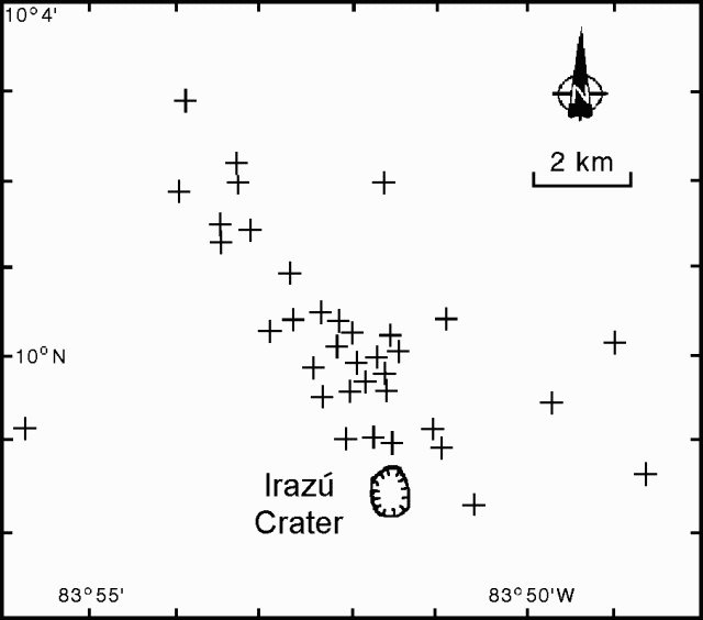 |
Figure 6. Irazú earthquake epicenters, 7-18 November 1994. Courtesy of OVSICORI-UNA. |
ICE reported that at 2248 on 8 December there was a phreatic explosion vented from a well-established fumarole on the upper NW-flank. They suggested that based on the response of the seismic station in San José, the released energy was similar to a M 4.4 earthquake. They further suggested that the explosion traveled toward the NW and destroyed forest on the upper slopes of the Rio Sucio, down to 2,500 m elevation. Explosion-triggered landslides and mudflows also followed along that drainage, but no lives were lost due to the absence of inhabitants in that area. The ash was composed of particles that appeared to be hydrothermally altered lithic fragments. The ash distribution pattern trended W (at an azimuth of 250°) and reached <= 30 km from the vent.
After the 8 December explosion, several tectonic earthquakes took place adjacent to Irazú, the largest, M 3.2 (at 0519 on 14 December) had a focal depth of 7 km. The explosion was also followed by many low-frequency and tremor-like signals. These were possibly triggered by the explosion.
Information Contacts: E. Fernández, J. Barquero, R. Van der Laat, F. de Obaldia, T. Marino, V. Barboza, and R. Sáenz, OVSICORI; G. Soto, Guillerma E. Alvarado, and Francisco (Chico) Arias, ICE.
Phreatic explosion on 8 December
On 8 December 1994 a small phreatic explosion vented from a well-established fumarole on the upper NW-flank (figure 7). Eighteen shallow October earthquakes (M <=2) and a 255-event November seismic swarm were both discussed in previous reports (19:10-11). ICE workers have suggested that based on the response in San José (station RSN of the national network), the explosion's released energy was similar to a M 4.4 earthquake. In addition, ICE workers noted that people living near Irazú felt the event with an intensity of IV on the modified Mercalli scale. Some residents also heard a jet-like sound and more than one explosion.
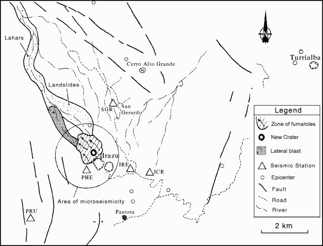 |
Figure 7. Sketch map illustrating the material associated with the phreatic explosion at Irazú, 8 December 1994. Courtesy of ICE. |
Prior to the 8 December explosion, but in the same area where it later took place, residents living nearby on the N-flank heard the sound of landslides beginning in November 1994. The sounds came from the N and NW sides of the volcano, an area underlain by deeply incised, altered rocks. The same area has hosted intense fumarolic activity, first observed in 1886. The fumaroles have remained active since then and in the last few years reached temperatures up to 95.4°C.
ICE reported that air surveys and field work completed a few days after the 8 December explosion revealed that the event left an irregularly shaped crater 60-80 m in diameter. Deposits related to landslides, lahars, and a small "lateral blast" were chiefly confined to one drainage radiating from the summit (figure 7). The blast apparently produced no juvenile material, but it deposited blocks, ash, sand, and mud. OVSICORI workers pointed out that after the explosion ash was carried SW and there were other tenuous reports of ashfall in an area 22 km W of the volcano and about 3 km from the capital.
Seismicity was erratic from the end of October through the end of December (figure 8). Although the 8 December event was followed neither by significant explosions nor earthquakes of comparable magnitude, on 9 December nearly 70 smaller earthquakes were registered on a newly installed portable system. That system, which began operation on 9 December, was placed very near the new explosion crater (station PHE, figure 7). Earthquakes declined in number after that (figures 8 and 9), and 5-7 days after the explosion even the system nearest the active crater detected only a few low-frequency events (figure 9).
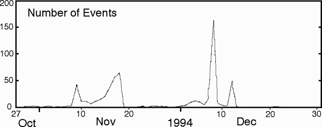 |
Figure 8. Number of earthquakes at Irazú during the interval 27 October through December 1994. Collected at seismic station IRZ2, 5 km SW of the main crater. Courtesy of OVSICORI. |
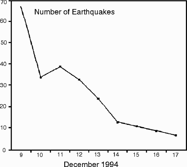 |
Figure 9. Number of earthquakes at Irazú during the interval 9 December to the middle of 17 December 1994. Collected using a portable system situated at the W end of Playa Hermosa ~800 m from the new explosion crater (station PHE, figure 1). Courtesy of ICE. |
ICE workers interpreted the explosion as small, phreatic, and they associated it with the November seismic swarm, decompression of a shallow hydrothermal system, and heavy rains destabilizing the NW flank. They also advocated increased seismic monitoring at the volcano.
Information Contacts: G. Soto, Guillermo E. Alvarado, and Francisco (Chico) Arias, ICE; E. Fernández, J. Barquero, R. Van der Laat, F. de Obaldia, T. Marino, V. Barboza, and R. Sáenz, OVSICORI.
Post-eruption mass wasting and fumaroles near source vent
The lake in the active crater remained greenish-yellow with its surface at a high level. Constant bubbling took place on the lake's N, NE, W, SW, and SE shores.
A phreatic eruption took place on 8 December, and since then mass wasting has partly covered the eruption's source vent. After the eruption an abnormally hot area appeared along the tributary east of the source vent, lying at a point with difficult access above a waterfall. The hot area caused vigorous evaporation and steam clouds to 50 m height. Steam columns from 50 to 100 m tall rose above both the source vent and an adjacent area located to the NW.
Small magnitude, sporadic microseisms were detected locally in January. During January the dry-tilt network and leveling lines showed no significant changes.
Information Contacts: Erick Fernández, Jorge Barquero, Rodolfo Van der Laat, Franklin de Obaldia, Tomás Marino, Vilma Barboza, and Rodrigo Sáenz, Observatorio Vulcanológico y Sismológico de Costa Rica, Universidad Nacional (OVSICORI-UNA); Gerardo J. Soto, Oficina de Sismología y Vulcanología, Departamento de Geología, Instituto Costarricense de Electricidad (ICE).
Lake rises one meter
"Irazú remains calm [in February]. Fumarolic activity is still weak in the main crater and on the NW flanks. The lake in the main crater has a temperature between 18 and 23°C, and the water surface rose about 1 m with respect to the same date last year. The lake holds an estimated 430 million m3 of water. Acidity and temperature of hot springs surrounding the volcano remain unchanged."
On 17 April Soto added that "tectonic-like seismic events have been recorded in the vicinity of the volcano during 1995 (8 in January, 8 in February, 14 in March . . . )." The hypocenters were located within 20 km of the main crater. The biggest earthquake took place on 21 March, about 15 km from the main crater.
Information Contacts: G. Soto, ICE.
Rainfall-induced mass wasting and three seismic events
OVSICORI-UNA reported that, with respect to January, the lake level in April dropped 50 cm. The greenish yellow lake constantly bubbled on its N, NE, W, and SW shores. Small landslides took place along the crater's N, E, and SW walls.
On the NW flank, where there had been a small phreatic eruption vented from a well-established fumarole in December 1994, fumaroles remained active at both the eruption site and on the adjacent crater's N wall. Rainfall caused new mass wasting that sent debris into the Rio Sucio.
ICE reported that Mauricio Mora recorded three seismic events in the vicinity of the volcano. These appeared similar to tectonic earthquakes; their hypocenters fell within about 10 km of Irazú's main crater.
Information Contacts: Erick Fernandez, Vilma Barboza, and Jorge Barquero, Observatorio Vulcanologico y Sismologico de Costa Rica, Universidad Nacional (OVSICORI-UNA), Apartado 86-3000, Heredia, Costa Rica; Gerardo J. Soto, Oficina de Sismologia y Vulcanologia del Arenal y Miravalles (OSIVAM), Instituto Costarricense de Electricidad (ICE), Apartado 10032-1000, San Jose, Costa Rica; Mauricio Mora, Escuela Centroamericana de Geologia, Universidad de Costa Rica.
Heavy rains trigger landslides and lahars
In June, the dark yellow, weakly bubbling lake rose to cover the entire crater floor at Irazú. Crater walls continued to slump into the lake on the N, E, and SE sides. At the site of the 9 December 1994 phreatic eruption (on the NW flank), the established fumaroles remained both near the collapsed wall and in the inner vent area. On the NE sector of the 9 December deposit, some fumaroles have ceased, while on the SW sector some new fumaroles have emerged. Accessible fumaroles had temperatures in the 80-90°C range.
The NE flank remained unstable and continued producing small landslides. Heavy rains have triggered lahars that have traveled down the upper to middle reaches of the Sucio river.
On 25 June, 3 earthquakes took place along local faults with epicenters 9-10 km NE of the main crater. The earthquake magnitudes were 2.5, 3.1, and 3.3; depths were 8, 6, and 8 km.
Information Contacts: E. Fernandez, R. Van der Laat, F. de Obaldia, T. Marino, V. Barboza, W. Jimenez, and R. Saenz, Observatorio Vulcanologico y Sismologico de Costa Rica, Universidad Nacional (OVSICORI-UNA), Apartado 86-3000, Heredia, Costa Rica; Mauricio Mora, Escuela Centroamericana de Geologia, Universidad de Costa Rica; G.J. Soto, Oficina de Sismologia y Vulcanologia del Arenal y Miravalles (OSIVAM), Instituto Costarricense de Electricidad (ICE), Apartado 10032-1000, San Jose, Costa Rica.
Minor increase in seismicity during August
Irazú's seismic station (IRZ2), located 5 km SW of the active crater, registered a minor increase in seismicity: During August and September there were low-frequency events detected 10 and 14 times, respectively. There were also higher-frequency events only detected locally during August and September; these occurred 30 and 48 times, respectively.
Information Contacts: E. Fernandez, E. Duarte, R. Saenz, W. Jimenez, and V. Barboza, Observatorio Vulcanologico y Sismologico de Costa Rica, Universidad Nacional (OVSICORI-UNA), Apartado 86-3000, Heredia, Costa Rica.
Local seismicity detected
During October Irazú's seismic station (IRZ2), located 5 km SW of the active crater, registered 14 low-frequency events and an additional 19 microseisms that were only detected locally.
Information Contacts: E. Fernandez, E. Duarte, R. Saenz, W. Jimenez, and V. Barboza, OVSICORI-UNA.
Dark yellow crater-lake water; discrete 7-hour seismic swarm
When visited in January, the crater lake's dark-yellow water remained high, covering the entire crater floor. Prominent fumaroles continued to bubble along the lake's N, NW, and SE shores. Slides continued to take place along the N, SW, and W walls. Seismic station IRZ2 (5 km SW) registered a swarm of 29 local earthquakes between 1512 and 2111 on 30 January; one was detected at a more distant station.
Information Contacts: Rodolfo Van der Laat, Vilma Barboza, Erick Fernández, Jorge Barquero, Franklin de Obaldia, Tomás Marino, and Rodrigo Sáenz, Observatorio Vulcanológico y Sismológico de Costa Rica, Universidad Nacional (OVSICORI-UNA), Apartado 86-3000, Heredia, Costa Rica.
Infrequent microseisms in February and March
During March, the dark-blue lake dropped 30 cm with respect to December 1995. Constant bubbling continued along the N, NW, W, and SE shores. The NW-flank site of the December 1994 eruption continued to emit low volumes of gas. During February and March seismic station IRZ2, 5 km SW of the crater, registered 31 and 19 microseisms, respectively. These events were only detected locally. Significant tilt was not detected over the deformation network.
Information Contacts: Erick Fernández, Elicer Duarte, Vilma Barboza, Rodolfo Van der Laat, and Enrique Hernandez, Observatorio Vulcanológico y Sismológico de Costa Rica, Universidad Nacional (OVSICORI-UNA), Apartado 86-3000, Heredia, Costa Rica; Gerardo J. Soto, Oficina de Sismología y Vulcanología, Departamento de Geología, Instituto Costarricense de Electricidad (ICE), Apartado 10032-1000, San José, Costa Rica.
No tilt in April-May but tens of local earthquakes
During May the lake's water was yellow in color and its surface dropped by 40 cm with respect to March 1996. Irazú's seismic station (IRZ2), located 5 km SW of the active crater, registered 55 and 26 events during April and May respectively; all were only detected locally. For the interval April through May dry-tilt measurements failed to show significant changes.
Information Contacts: Erick Fernández, Elicer Duarte, Vilma Barboza, Rodolfo Van der Laat, and Enrique Hernandez, Observatorio Vulcanológico y Sismológico de Costa Rica, Universidad Nacional (OVSICORI-UNA), Apartado 86-3000, Heredia, Costa Rica; Gerardo J. Soto, Oficina de Sismología y Vulcanología, Departamento de Geología, Instituto Costarricense de Electricidad (ICE), Apartado 10032-1000, San José, Costa Rica.
Earthquakes and deformation low to nearly absent
When visited in July the lake filled the crater with greenish yellow water. Constant bubbling issued from many parts of the lake (N, NW, W, SW, and SE sides) and landslides continued to occur down the E, N, and W crater walls. The area on the NW flank where the phreatic eruption had taken place in December 1994 remained fumarolically active.
During the months of June, July, and August the Irazú seismic station registered 48, 33, and 13 local earthquakes, respectively. Survey of the deformation network failed to detect any significant changes since 1994. During February through most of August, dry-tilt at three stations near the summit changed little if any.
Information Contacts: E. Fernández, E. Duarte, V. Barboza, R. Van der Laat, E. Hernandez, M. Martinez, and R. Sáenz, Observatorio Vulcanológico y Sismológico de Costa Rica, Universidad Nacional (OVSICORI-UNA), Apartado 86-3000, Heredia, Costa Rica.
Minor seismicity; no significant tilt in late 1996
Situated 5 km SW of the crater, the local seismic station (IRZ2) registered 18 local events during September 1995. Although a survey of the tilt network that extends 3.5 km S of the crater has detected no significant tilt since 1994, three of five electronic inclinometers measured an average tilt of 5.6 µrad/year since 1994 (figure 10).
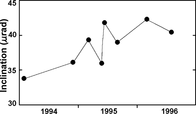 |
Figure 10. Tilt at Irazú from an electronic inclinometer ("dry-tilt" at station Torres) during 26 January 1994-1 August 1996. Measurement times are shown as dots. Courtesy of OVSICORI-UNA. |
Information Contacts: E. Fernández, E. Duarte, V. Barboza, R. Van der Laat, E. Hernandez, M. Martinez, and R. Sáenz, Observatorio Vulcanológico y Sismológico de Costa Rica, Universidad Nacional (OVSICORI-UNA), Apartado 86-3000, Heredia, Costa Rica.
Comparatively high numbers of earthquakes in April and May
In April and May there were 107 and 136 earthquakes, respectively, a higher number than is typical. These were mainly detected locally. One M 1.9 earthquake centered 4 km SW of the active crater at a depth of 3.8 km took place at 0054 on 6 April. A M 2.2 earthquake struck at 0437 the same day at 5.2 km depth centered 11 km NW of the crater. On 19 May the station 5 km SW (IRZ2) registed a swarm consisting of 23 high-frequency earthquakes.
Irazú lies along a fault zone shaken by repeated earthquakes in the past 6 years. It was estimated that ~40 of May's 136 earthquakes were associated with faulting. Earlier summaries of monthly earthquakes for December 1996, and January and March 1997 reported 51, 82, and 92 events, respectively.
Irazú's ashfalls frequently reached San Jose, 25 km to the E, during its historically most active period in 1963- 65. That period of intermittent, weak-to-moderate explosive activity severely affected agricultural areas over much of central Costa Rica, causing major economic problems. During the same interval, 46 secondary mudflows swept down the Rio Reventado valley.
Information Contacts: E. Fernandez, R. Van der Laat, F. de Obaldia, T. Marino, V. Barboza, W. Jimenez, R. Saenz, E. Duarte, M. Martinez, E. Hernandez, and F. Vega, Observatorio Vulcanologico y Sismologico de Costa Rica, Universidad Nacional (OVSICORI-UNA), Apartado 86-3000, Heredia, Costa Rica.
Four-days of earthquakes on nearby fault leave volcano undisturbed
A seismic swarm adjacent to Irazú occurred during 15-18 June (figure 11). During this interval there were 1,311 swarm-related earthquakes, but including other locally detected earthquakes, the total reached 1,550 (figure 11). The swarm's largest events, M 3.0 and 3.3, appeared in the midst of the swarm (at 0305 and 0530 on 16 June). The swarm failed to induce reported morphologic changes at the volcano; nor did it cause significant changes at the tilt network, which included the main crater.
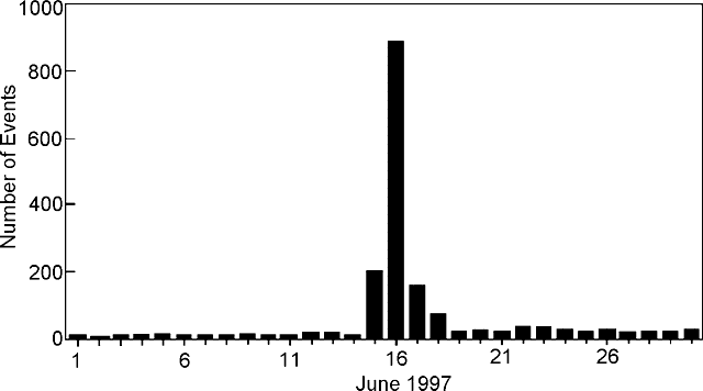 |
Figure 11. Histogram of daily earthquakes registered at Irazú's seismic station "IRZ2," 5 km SW of the active crater, showing the 15-18 June 1997 seismic swarm. Courtesy of OVSICORI-UNA. |
Many earthquakes fell on the Retes fault (figure 12); however, some of the stronger ones were felt near the volcano. Located epicenters chiefly clustered ~2-7 km SSE of the volcano. The earthquakes appeared at depths of 1-8 km, but those well-located were in the 1-4 km range. Epicenters remained confined to a narrow 8-km-long zone trending NW-SE; the similarly trending fault is thought to pass ~4 km SW of Irazú at the point where it intersects Cerro Retes.
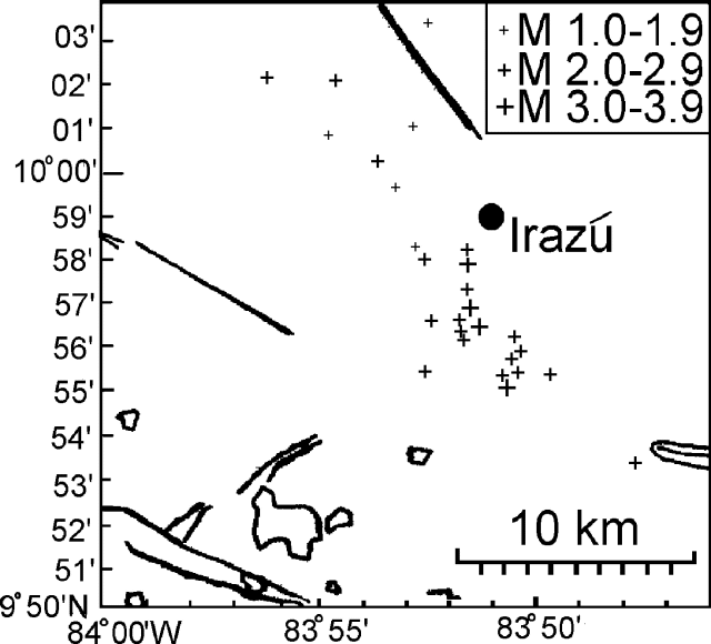 |
Figure 12. Sketch map of epicenters for the 15-18 June seismic event along the Retes fault adjacent Irazú. Heavy lines indicate faults; circled areas indicate lakes. The exact location of Retes fault is undisclosed. Courtesy of OVSICORI-UNA. |
During July there were 205 earthquakes, including two of M 2.1 and 2.6 at depths of 5.8 and 17 km, respectively. During August and September there were 106 and 185 small-magnitude local earthquakes.
Information Contacts: E. Fernandez, R. Van der Laat, F. de Obaldia, T. Marino, V. Barboza, W. Jimenez, R. Saenz, E. Duarte, M. Martinez, E. Hernandez, and F. Vega, Observatorio Vulcanologico y Sismologico de Costa Rica, Universidad Nacional (OVSICORI-UNA), Apartado 86-3000, Heredia, Costa Rica; G.J. Soto, Oficina de Sismologia y Vulcanologia del Arenal y Miravalles (OSIVAM), Instituto Costarricense de Electricidad (ICE), Apartado 10032-1000, San Jose, Costa Rica.
The 26-27 December seismic swarm 20 km from summit (220 earthquakes)
During 26-27 December a small seismic swarm at Irazú consisted of 220 earthquakes. At the swarm's peak 109 earthquakes occurred in 15 hours. The epicenters fell 20 km NNW of the summit, originating on a local fault. The largest earthquake, at 0154 on 27 December, was M 2.9. It had a focal depth of 5 km and an epicenter 20 km NW of the summit. For comparison, during the months of January, February, and March 1998, the respective counts consisted of 58, 59, and 70 local earthquakes.
During 20 and 22 February seven earthquakes took place, including one of M 2.3 and another of M 1.8. Both of these events had epicenters within 7 km of the summit; their respective focal depths were at 8 km and 1 km.
During January the lake in the active crater remained greenish yellow and lacked bubbling along its shores. These areas were not mentioned as active again during February-March, although the lake's color was later described as light green. The monthly fluctuations in lake level noted for December to March were under a meter. During early 1998 small landslides continued to occur along the crater's N, E, and W walls. During February, fumaroles remained active on the volcano's NW flanks; their visible outputs remained moderate and their temperatures measured 91°C.
Information Contacts: E. Fernandez, V. Barboza, R. Van der Laat, R. Saenz, E. Duarte, E. Malavassi, T. Marino, M. Martinez, and E. Hernandez, Observatorio Vulcanologico y Sismologico de Costa Rica, Universidad Nacional (OVSICORI-UNA), Apartado 86-3000, Heredia, Costa Rica; Mauricio Mora Fernandez, Sección de Sismologia, Vulcanologia y Exploración Geofisica, Escuela Centroamericana de Geología, Universidad de Costa Rica, P.O. Box 35-2060, San José, Costa Rica.
Minor earthquakes, tremor, and small landslides during May
During May, water in the active crater lake was pale yellow in color and small landslides on the N, E, and W walls continued. Gas emissions remained moderate. During May, the local seismic station (IRZ2) registered a total of 48 microseisms and three local tectonic earthquakes. Two of these earthquakes struck on 23 and 24 May, with epicenters 5.5 to 6.5 km SW of the principal crater. One was at about 5 km depth, the other at an unspecified depth with a magnitude of 2.2.
Information Contacts: E. Fernandez, V. Barboza, E. Duarte, R. Saenz, E. Malavassi, M. Martinez, and Rodolfo Van der Laat, Observatorio Vulcanologico y Sismologico de Costa Rica, Universidad Nacional (OVSICORI-UNA), Apartado 86-3000, Heredia, Costa Rica.
Occasional earthquakes and 5-70 microseisms a month during last 1.5 years
In late 1998 and early 1999, seismographic station IRZ2 continued to register a few microseisms and occasional earthquakes (figure 13). During February and March, the color of the lake was clear yellow; in May, green. As is typical, the lake contained zones of constant bubbling. Weak fumarolic activity continued on the NE flank.
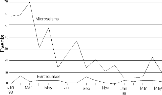 |
Figure 13. Monthly seismicity at Irazú, January 1998-April 1999. Courtesy of OVSICORI-UNA. |
Information Contacts: E. Fernandez, V. Barboza, E. Duarte, R. Saenz, E. Malavassi, M. Martinez, and R. Van der Laat, T. Marino, and E. Hernandez, Observatorio Vulcanologico y Sismologico de Costa Rica, Universidad Nacional (OVSICORI-UNA), Apartado 86-3000, Heredia, Costa Rica; Wendy Perez Fernandez, Seccion de Seismologia, Vulcanologia y Exploracion Geofisica, Escuela Centroamericana de Geologia, Universidad de Costa Rica, POB 35-2060, San Jose, Costa Rica.
Microseisms during June-November 1999 take place 12-61 times a month
Seismic monitoring disclosed many days during June-November 1999 without any detectable microseisms. Monthly averages for July-November 1999 (table 6) tallied 12 to 61 microseisms a month, an average of roughly 0.5-2 microseisms per day. Other monitoring data were absent. The last eruption at Irazú consisted of a small phreatic explosion in December 1994 (BGVN 19:12).
Table 6. Monthly microseisms at Irazú as recorded at station IRZ2, located 5 km SW of the active crater, July-November 1999. The two months with available RSAM data show the range of computed values (e.g., October estimates of 7 to 101 units). Courtesy of OVSICORI-UNA.
| Month | Number of microseisms | RSAM |
| Jul 1999 | 61 | -- |
| Aug 1999 | 17 | -- |
| Sep 1999 | 35 | -- |
| Oct 1999 | 29 | 7-101 |
| Nov 1999 | 12 | 8-136 |
Information Contacts: E. Fernandez, E. Duarte, V. Barboza, R. Sáenz, E. Malavassi, R. Van der Laat, T. Marino, J. Barquero, and E. Hernández, Observatorio Vulcanologico y Sismologico de Costa Rica, Universidad Nacional (OVSICORI-UNA), Apartado 86-3000, Heredia, Costa Rica.
Feeble microseismicity continues into early 2000
This report covers January-June 2000. In January seismographic station IRZ2 (5 km SW of the active crater) recorded seven small-magnitude earthquakes. During February and March no activity was recorded. In April, May, and June, respectively, IRZ2 recorded 10, 12, and 30 earthquakes. The latter month included low-frequency events.
During May the level of the crater lake decreased by 50 cm. During the dry period, the lake's color was yellow/green, and a significant amount of algae covered its surface. On the lake's NE and S shore lines constant bubbling continued; the temperature of the lake was 18°C. The E, N, and W crater walls continued sliding toward the lake. Fumarolic activity on the NE flank continued at a low level.
In June the crater lake's surface rose 40 cm in comparison to May. The lake color was now green and its surface was still covered by abundant algae. The NE crater wall continued sliding, partly covering some fumaroles while others completely disappeared. Also, along the NE wall three new thermal features appeared with temperatures that fluctuated between 22 and 54°C. On the NE and S shore the bubbling stopped during June.
Information Contacts: Observatorio Vulcanologico y Sismologico de Costa Rica, Universidad Nacional (OVSICORI-UNA), Apartado 86-3000, Heredia, Costa Rica.
Small-magnitude seismic events; crater lake level generally constant
Our last report (BGVN 25:06) covered activity at Irazú through June 2000, which included feeble microseismicity and small fluctuations in the water level of the crater lake. Similar activity occurred during August 2000 through at least September 2001.
The level of the crater lake generally stayed the same, covering the entire bottom of the crater. The IRZ2 seismograph continued to register varying numbers of small seismic events: 33 in August 2000, 21 in September 2000, 16 in March 2001, 10 in May 2001, 108 in June 2001, and 68 in July 2001 (data from other months not available).
The lake was green, with bubbling occurring mostly at the N end of the crater, and also in the NW and NE. Bubbling was reported at the S end of the crater during August 2001. The N and W wall continued sliding toward the lake. Fumarolic activity continued at the NW flank.
Information Contacts: Observatorio Vulcanológico y Sismológico de Costa Rica, Universidad Nacional (OVSICORI-UNA), Apartado 86-3000, Heredia, Costa Rica.
Tranquil in 2001-3; fumarolic condensate of pH 2.0-3.5, 0-2 earthquakes/day
This report consists of contributions from investigators at OVSICORI-UNA and UCR-ICE, who both monitor Irazú. Small-magnitude seismicity and stable fumarolic and crater lake conditions were noted in the previous Irazú report (BGVN 26:10). Weak seismicity and stable conditions continued through at least December 2003.
OVSICORI-UNA observations. Seismicity and fumarolic emissions at the volcano remained low over the reporting interval September 2001 to December 2003.
The color of the principal crater lake varied from greenish yellow (January, October, and December 2002; January and May 2003) to light yellow (June 2002), to yellow (February and March 2002), and strong yellow (February, March, and April 2003). From May 2003 on the color remained green, particularly dark green. The strong yellow color correlated with mass wasting from the crater walls, which introduced strongly colored fine-grained material into the lake. On 8 February 2003 the color briefly shifted from yellow to reddish due to mass wasting in zones along the E and ENE walls. The February mass-wasting events did not produce definable seismic signals at the volcano's sole station (IRZ2, located 5 km from the crater).
In January, September, October, and November 2002, the lake's surface was comparatively high, covering the crater floor. An interval of dry weather with consequent lower lake levels, bubbling along the lake's margins, and small landslides into the crater were noted during February and March 2002. In March and April 2002, the lake temperature was 17°C. During March 2002, fumaroles on the NE shore had temperatures of 39-50°C. The lake temperature measured 15°C during November 2002, with one fumarole measuring 42°C. During August 2003 a fumarolic temperature of 47°C was measured on the NE lake shore.
The highest temperature of the reporting interval was in July 2003 when the NE-flank fumarole was measured at 88°C (N-flank fumarole temperatures over 80°C have been reported for almost 40 years).
Seismicity seldom averaged more than about one or two local earthquakes per day (table 7). A few volcano-tectonic and long-period earthquakes were reported (e.g., 6 LP earthquakes in September 2001; 2 in November 2002; and 4 in May 2003). Tremor was not reported.
Table 7. Earthquakes registered at the Irazú seismic instrument, 5 km SW of the crater. "--" indicates a lack of mention or a malfunctioning system. When the system functioned for only part of the month, the number of functional days is in parenthesis. Courtesy of OVSICORI-UNA.
| Month | Total earthquakes (days of operation) |
| Sep 2001 | 39 (20 days) |
| Oct 2001 | 56 |
| Nov 2001 | -- |
| Dec 2001 | -- |
| Jan 2002 | 50 |
| Feb 2002 | 23 (16 days) |
| Mar 2002 | 50 |
| Apr 2002 | -- |
| May 2002 | -- |
| Jun 2002 | 54 |
| Jul 2002 | 19 |
| Aug 2002 | 11 |
| Sep 2002 | -- |
| Oct 2002 | 24 |
| Nov 2002 | 29 |
| Dec 2002 | -- |
| Jan 2003 | 16 |
| Feb 2003 | 20 |
| Mar 2003 | 15 |
| Apr 2003 | 7 |
| May 2003 | 24 |
| Jun 2003 | 11 |
| Jul 2003 | 8 |
| Aug 2003 | 23 |
| Sep 2003 | 29 |
| Oct 2003 | 43 |
| Nov 2003 | 11 |
| Dec 2003 | -- |
UCR-ICE observations. Mora (2001 and 2002) presented monthly temperature and condensate-pH data for a sulfurous fumarole on the outer N slopes of Irazú. Measurements of the temperature began in 2001. The temperature remained at 90.0 ± 1°C throughout that year except in June (88.6°C) and December (86.0°C). The year 2002 began with the fumarole at 79.6°C in January, but by April it was at 89.6°C and remained relatively constant (87.5-89.6°C) until cooling in December to 86.5°C. The cooler fumarole temperatures seen annually around December-January are well established and are thought to be caused by cool water descending from the summit into the headwater regions.
During the period January-August 2002, the pH of the fumarole's condensate was 2.0; increasing to 3.5 in September, and remaining near that value (3.0-3.5) throughout the rest of year. During 2002 the crater lake level changed by less than ~ 2 m overall. Mora commented that the green-colored water seen frequently in 2002 was the result of algae adapting to the low-pH conditions.
Heavy rains during November and December 2001 formed an ephemeral lake on the floor of the inactive oblong-shaped Diego de la Haya crater (SE of the principal crater), which grew to ~ 100 x 20 m.
References. Mora, R., 2002, Informe anual de la actividad de la Cordillera Volcánica Central, 2002, Costa Rica (proofed and revised by Alvarado, G., Fernández, M., Mora, M., Paniagua S., and Ramírez, C.): Universidad de Costa Rica, Red Sismológica Nacional, UCR-ICE, Sección de Sismología, Vulcanología y Exploración Geofísica (published June 2003 as mini-CD Rom with PDF files).
Mora, R., 2001a, Informe semestral de la actividad de la Cordillera Volcánica Central, Enero-Junio 2001, Costa Rica: Universidad de Costa Rica, Red Sismológica Nacional, UCR-ICE, Sección de Sismología, Vulcanología y Exploración Geofísica (published November 2001 as mini-CD Rom with PDF files).
Mora, R., 2001b, Informe semestral de la actividad de la Cordillera Volcánica Central, Julio-Diciembre 2001, Costa Rica (proofed and revised by Alvarado, G., Fernández, M., Montero, W., and Ramírez, C.): Universidad de Costa Rica, Red Sismológica Nacional, UCR-ICE, Sección de Sismología, Vulcanología y Exploración Geofísica (published 6 May 2001 as mini-CD Rom with PDF files).
Information Contacts: E. Fernández, E. Duarte, E. Malavassi, R. Sáenz, V. Barboza, R. Van der Laat, T. Marino, E. Hernández, and F. Chavarría, Observatorio Vulcanológico y Sismológico de Costa Rica (OVSICORI-UNA), Apartado 86-3000, Heredia, Costa Rica; Jorge Barquero and Wendy Sáenz, Laboratory de Química de la Atmósfera (LAQAT), Depto. de Química, Universidad Nacional, Heredia, Costa Rica; María Martínez (at both affiliations above); Orlando Vaselli and Franco Tassi, Department of Earth Sciences, University of Florence, Via La Pira 4, 50121 Florence, Italy; R. Mora (Amador), C. Ramírez, and M. Fernández, Universidad de Costa Rica, Laboratory de Sismología, Vulcanología y Exploración Geofisico, Apptd. 560-2300, Curridabat, San José, Costa Rica.
Seismicity and degassing remain low, January 2004-September 2007
The Observatorio Vulcanológico y Sismológico de Costa Rica (OVSICORI-UNA) reported small-magnitude seismicity and stable fumarolic and crater lake conditions at Irazú over the period September 2001 to December 2003 (BGVN 28:12). This report summarizes monthly contributions from OVSICORI-UNA from January 2004 through September 2007.
Activity during January-December 2004. The lake level at Irazú remained high through 2004 with a green color from January to September and a light green and greenish yellow color in October and November. Convection cells occurred in the NW, SW, SE, NE, N edges of the lake throughout the year. Small areas of minor mass wasting occurred in the NE and SW walls, and fumarolic activity on the NW side remained constant with a low level of gas emission. A seismograph located 5 km SW of the active crater registered mild tectonic and low-frequency earthquakes throughout 2004. Peak activity occurred on 19 July 2004, with nine earthquakes occurring over four hours and an intensity of M 1.2-1.8 at focal depths of 5-15 km.
Activity during January-November 2005. The lake level remained high through 2005 with a greenish yellow color through April and darker green from May through November. A ring of lighter yellow color indicating iron-oxide deposits was visible from March through November 2005. Convection cells occurred in similar manner to the 2004 interval, and toward the lake's center of the lake. Small areas of minor mass wasting occurred in the NE and SW walls and fumarolic activity on the NW side remained constantly low. From January through March and again in October 2005, earthquakes (M 1-2) 3-16 km deep occurred from the active crater to a distance of 20 km NW and 15 km SE .
Activity during March-December 2006. During March through December 2006, the lake level at Irazú was high with a yellowish green color. The SW crater wall showed areas of minor mass wasting moving toward the lake. Similar to January-November 2005, convection cells were observed in various areas. In August, the gas emission temperature of the NW-flank fumarole was measured at 86°C (N-flank fumarole temperatures over 80°C have been reported for almost 40 years). In November 2006, the lake level, convection cells, and fumarolic activity remained constant but the lake color changed to light green. A seismograph located 5 km SW of the active crater registered continuing low level tectonic and low-frequency earthquakes. In mid-December, earthquake activity was reported by local residents, but no other changes were recorded.
Activity during 2007. In February 2007, the lake level receded, and the color changed to yellowish green. In March, measurements of the lake level indicated a descent of 4.48 m, with regard to September of the 2005 and lake color remained a greenish yellow with a temperature of 15 °C. Temperature at a convection cell at the NE edge was 34 °C. During the period March-September, the lake level continued to descend and fell an additional 3.87 m. The lake retained a light green color, with convection calls in the NE, at the N edge, and toward the center. Small areas of minor mass wasting continued in the SW crater wall, and fumaroles on the NW side continued minor degassing.
Information Contacts: E. Fernández, E. Duarte, R. Van der Laat, W. Sáenz, M. Martínez, V. Barboza, E. Malavassi, R. Sáenz, and J. Brenes, Observatorio Vulcanologico Sismologica de Costa Rica-Universidad Nacional (OVSICORI-UNA), Apartado 86-3000, Heredia, Costa Rica (URL: http://www.ovsicori.una.ac.cr/).
Crater lake dries and regional acid-rain report
In April 2010 the lake within Irazú's crater dwindled to only a few centimeters depth and from May to August the lake was dry enough to allow plants to grow up to 10 cm high. Water began to accumulate in September 2010 but disappeared again during the following month. Since November 2010 water returned to the crater and as late as April 2011, a shallow turquoise-blue lake was maintained. Continuous monitoring of acid rain on Irazú's flanks reflected contributions from Turrialba. Often called Irazú's "twin volcano," Turrialba is less than 10 km to the ENE and during the past 4 years it has caused a region-wide increase in acid rain. Covering January 2004 through September 2007, the last Bulletin report on Irazú (BGVN 32:11) highlighted decreasing lake levels, fumarolic changes, and minor mass wasting on the crater walls during January 2004 to March 2007 (see table 8 for a summary of lake changes).
Table 8. Changing lake conditions based on observations of Irazú's crater. Double asterisks indicate times when the lake disappeared; "--" fills cells where no data is available; lake levels are reported qualitatively except for the 7 October to 12 March 2010 time interval when absolute values were measured. This summary is based on ICE data and OVSICORI Monthly Reports.
| Date | Lake level | Temp. °C | Water color | Notes |
| ** Apr 1990 | Empty | -- | -- | -- |
| 1991-1994 | Stable | -- | green | Infrequent Bubbles |
| 08 Dec 1994 | ~VEI 2 explosion from the NW outer flank fumarole~ | -- | -- | -- |
| 1994-1996 | Stable | -- | green | Bubbles |
| May 2000 | Decreasing | 18 | yellow-green | Bubbles |
| Jan 2001 | ~30 | -- | green | Bubbles |
| 08 Feb 2003 | Stable | 15 | reddish | Rockslide into lake |
| Jan-Dec 2004 | Stable | -- | green | Convection cells at edges |
| Jan-Nov 2005 | Stable | -- | green | Convection cells in center |
| Mar-Dec 2006 | Stable | -- | increasingly yellow-green | Convection cells in various locations |
| Mar-Sep 2007 | Decreasing | 145 | light-green | Convection cells at edges and center; bubbles |
| 20 Sep 2007-Mar 2008 | Decreasing | 17 | -- | Bubbles |
| 05 Mar 2008-07 Oct 2009 | Decreasing | 14 | dark green | Bubbles |
| 07 Oct 2009-12 Mar 2010 | 1.4 m | 16 | dark-to-light green | -- |
| Apr 2010 | Only few cm | -- | -- | -- |
| ** May-Aug 2010 | Empty | -- | -- | Plants on crater floor |
| Sep 2010 | Re-forming | -- | -- | -- |
| ** Oct 2010 | Empty | -- | -- | -- |
| Nov 2010-Jan 2011 | Forming | -- | turquoise | -- |
| Feb-Apr 2011 | Few meters | -- | turquoise-to-blue | -- |
On 22 July 2010 a team of investigators from Observatorio Vulcanologico Sismologica de Costa Rica-Universidad Nacional (OVSICORI-UNA) descended to the dry crater floor. They documented changes in vegetation, fumaroles, and clay deposition on the crater floor. Photos taken during prior trips provided comparisons with previous conditions (figure 14). Rockfalls and minor mass wasting had been occurring regularly and the long runout of debris across the crater floor was visible during this investigation. Most of the debris fell from the E and SW walls. On the NE side of the dry crater a rocky area emitted low temperature (24°C) sulfur-smelling gases from three aligned vents. Higher temperatures (86°C) were measured from fumaroles on the N side of the crater but they appeared to be releasing gas with less energy than observed in the past years when bubbles were visible within the lake. Another interesting finding was a waterfall on the inside of the crater on the SW wall; this small waterfall did not have sufficient volume to pool on the crater floor and instead soaked directly into the surrounding clay.
|
Figure 14. Views taken from Irazú's S rim. (top) The crater on 24 April 2004 contained a turquoise lake. (bottom) A repeat photo taken on 22 July 2010 shows the lake had disappeared; the former lake level and the clay base on the crater floor are marked. Since November 2010 water had accumulated and as of April 2011, was several meters deep. Courtesy of Eliecer Duarte, OVSICORI-UNA. |
The water level in Irazú's crater has been variable throughout time; the Bulletin recorded a dry crater during February 1977 and June 1987 (SEAN 12:07), and April 1990 (BGVN 15:04). Factors highlighted during the IAVCEI CVL-7 ("Commission of Volcanic Lakes" Costa Rica, 10-19 March 2010) included complex connections with Turrialba, seasonal effects, infiltration within the crater, and the role of mass wasting. The mechanism for the recent disappearance of the lake is still under investigation by OVSICORI-UNA and ICE investigators (Guillermo Alvarado, personal communication).
Erosion. Mass wasting had been an ongoing process for at least 10 years. Material is primarily shed from the E and SW walls and the lake contained islands of black and red material formed from the debris. In February 2003 a major rockslide into the lake caused the water color to change from green to shades of red. An analysis of seismicity during that month showed no correlation to these slope failures (BGVN 28:12). Cracks along the NW rim formed and widened since December 2007; these cracks caused blocks up to 3 x 20 m to fall from the rim in March 2008.
Local gas measurements. Since the large phreatic explosion in December 1994 (BGVN 19:12), the NW fumarole has been releasing low gas emissions regularly. Different temperature measurements recorded since June 2010 ranged between 90°C to 86°C. To monitor changes in sulfur dioxide output from Irazú, a network of three stations collected rain samples from sites along the volcano's flanks.
The pH data from September 2004 through July 2010 were plotted in the OVSICORI-UNA July 2010 monthly report. The results correlate pH changes to much larger degassing events occurring at Turrialba, a neighboring volcano that began major degassing in 2007. Only the "Borde Sur" station was sampling continuously but the other two stations reflected similar trends in acidity. Despite irregular fluctuations, a decreasing pH trend began in 2007. The lowest point of the trend was measured by "Borde Este" at approximately pH 3.25. Where there "Pacayas" station data began, the trend appeared to have stabilized between pH 3.25 and 4.75.
References. D. Rouwet, R.A. Mora-Amador, C.J. Ramírez-Umaña, G. González, Seepage of "aggressive" fluids reduce volcano flank stability: the Irazú and Turrialba case, Costa Rica, Abstract, CVL 7 Workshop Costa Rica, IAVCEI-Commission of Volcanic Lakes, March 2010.
Information Contacts: E. Duarte, Observatorio Vulcanologico Sismologica de Costa Rica-Universidad Nacional (OVSICORI-UNA), Apartado 86-3000, Heredia, Costa Rica (URL: http://www.ovsicori.una.ac.cr/); G. Alvarado and G.J. Soto, Oficina de Sismologia y Vulcanologia del Arenal y Miravalles (OSIVAM), Instituto Costarricense de Electricidad (ICE), Apartado 10032-1000, San Jose, Costa Rica.
This compilation of synonyms and subsidiary features may not be comprehensive. Features are organized into four major categories: Cones, Craters, Domes, and Thermal Features. Synonyms of features appear indented below the primary name. In some cases additional feature type, elevation, or location details are provided.
Synonyms |
||||
| Cartago, Volcán de | Santabárbara Mortal de la Naturalez | ||||
Cones |
||||
| Feature Name | Feature Type | Elevation | Latitude | Longitude |
| Alto Grande, Cerro | Cone | 2803 m | ||
| Cabeza de Vaca, Cerro | Stratovolcano | 3059 m | 9° 58' 10" N | 83° 53' 14" W |
| Doussaints | Cone | 2824 m | 9° 56' 38" N | 83° 51' 13" W |
| Guardián, Cerro | Pyroclastic cone | 3030 m | 9° 57' 12" N | 83° 51' 1" W |
| Noche Buena, Cerro | Pyroclastic cone | 3210 m | 9° 58' 12" N | 83° 50' 34" W |
| Pasquí, Cerro | Pyroclastic cone | 2552 m | 9° 55' 49" N | 83° 50' 48" W |
| Quemados, Cerro de | Pyroclastic cone | 2733 m | 9° 56' 19" N | 83° 51' 2" W |
| Retes, Cerro | Cone | 3179 m | 9° 58' 10" N | 83° 52' 21" W |
Craters |
||||
| Feature Name | Feature Type | Elevation | Latitude | Longitude |
| Crater Principal | Crater | 3055 m | 9° 58' 57" N | 83° 50' 59" W |
|
Diego de la Haya
Diego de la Haya Fernández |
Crater | 3325 m | 9° 58' 52" N | 83° 50' 45" W |
| Playa Hermosa | Crater | 3318 m | 9° 58' 40" N | 83° 50' 55" W |
Thermal |
||||
| Feature Name | Feature Type | Elevation | Latitude | Longitude |
| Fumaroles, Las | Fumarole | |||
|
|
||||||||||||||||||||||||
There is data available for 24 confirmed Holocene eruptive periods.
[ 1994 Dec 8 - 1994 Dec 8 ] Uncertain Eruption
| Episode 1 | Phreatic Episode | Upper NW flank | |||||||||||||||||||||||||||||||||||||||
|---|---|---|---|---|---|---|---|---|---|---|---|---|---|---|---|---|---|---|---|---|---|---|---|---|---|---|---|---|---|---|---|---|---|---|---|---|---|---|---|---|
| 1994 Dec 8 - 1994 Dec 8 | Evidence from Observations: Reported | |||||||||||||||||||||||||||||||||||||||
|
List of 6 Events for Episode 1 at Upper NW flank
| ||||||||||||||||||||||||||||||||||||||||
1977 Mar 3 Confirmed Eruption Max VEI: 1
| Episode 1 | Eruption Episode | |||||||||||||||||||||||||
|---|---|---|---|---|---|---|---|---|---|---|---|---|---|---|---|---|---|---|---|---|---|---|---|---|---|
| 1977 Mar 3 - Unknown | Evidence from Observations: Reported | ||||||||||||||||||||||||
|
List of 3 Events for Episode 1
| |||||||||||||||||||||||||
[ 1974 Mar 2 - 1974 Mar 7 ] Discredited Eruption
[ 1967 Aug 7 ] Discredited Eruption
1963 Mar 13 - 1965 Feb 13 Confirmed Eruption Max VEI: 3
| Episode 1 | Eruption Episode | ||||||||||||||||||||||||||||||||||||||||||||||||||||||||||||||||||||||||||||||||||||||||||||||||||||||||||||||||||||||||||||||||||
|---|---|---|---|---|---|---|---|---|---|---|---|---|---|---|---|---|---|---|---|---|---|---|---|---|---|---|---|---|---|---|---|---|---|---|---|---|---|---|---|---|---|---|---|---|---|---|---|---|---|---|---|---|---|---|---|---|---|---|---|---|---|---|---|---|---|---|---|---|---|---|---|---|---|---|---|---|---|---|---|---|---|---|---|---|---|---|---|---|---|---|---|---|---|---|---|---|---|---|---|---|---|---|---|---|---|---|---|---|---|---|---|---|---|---|---|---|---|---|---|---|---|---|---|---|---|---|---|---|---|---|
| 1963 Mar 13 - 1965 Feb 13 | Evidence from Observations: Reported | |||||||||||||||||||||||||||||||||||||||||||||||||||||||||||||||||||||||||||||||||||||||||||||||||||||||||||||||||||||||||||||||||
|
List of 24 Events for Episode 1
| ||||||||||||||||||||||||||||||||||||||||||||||||||||||||||||||||||||||||||||||||||||||||||||||||||||||||||||||||||||||||||||||||||
[ 1962 Aug 9 ] Discredited Eruption
1939 May 18 - 1940 Feb Confirmed Eruption Max VEI: 2
| Episode 1 | Eruption Episode | |||||||||||||||||||||||||||||||||||
|---|---|---|---|---|---|---|---|---|---|---|---|---|---|---|---|---|---|---|---|---|---|---|---|---|---|---|---|---|---|---|---|---|---|---|---|
| 1939 May 18 - 1940 Feb | Evidence from Observations: Reported | ||||||||||||||||||||||||||||||||||
|
List of 5 Events for Episode 1
| |||||||||||||||||||||||||||||||||||
1933 Mar 22 (?) - 1933 Jul 25 Confirmed Eruption Max VEI: 2
| Episode 1 | Eruption Episode | |||||||||||||||||||||||||||||||||||||||||||||
|---|---|---|---|---|---|---|---|---|---|---|---|---|---|---|---|---|---|---|---|---|---|---|---|---|---|---|---|---|---|---|---|---|---|---|---|---|---|---|---|---|---|---|---|---|---|
| 1933 Mar 22 (?) - 1933 Jul 25 | Evidence from Observations: Reported | ||||||||||||||||||||||||||||||||||||||||||||
|
List of 7 Events for Episode 1
| |||||||||||||||||||||||||||||||||||||||||||||
1930 Oct Confirmed Eruption Max VEI: 2
| Episode 1 | Eruption Episode | |||||||||||||||||||||||||
|---|---|---|---|---|---|---|---|---|---|---|---|---|---|---|---|---|---|---|---|---|---|---|---|---|---|
| 1930 Oct - Unknown | Evidence from Observations: Reported | ||||||||||||||||||||||||
|
List of 3 Events for Episode 1
| |||||||||||||||||||||||||
1928 Feb 14 - 1928 May 26 ± 5 days Confirmed Eruption Max VEI: 2
| Episode 1 | Eruption Episode | |||||||||||||||||||||||||
|---|---|---|---|---|---|---|---|---|---|---|---|---|---|---|---|---|---|---|---|---|---|---|---|---|---|
| 1928 Feb 14 - 1928 May 26 ± 5 days | Evidence from Observations: Reported | ||||||||||||||||||||||||
|
List of 3 Events for Episode 1
| |||||||||||||||||||||||||
1924 Mar - 1924 Apr Confirmed Eruption Max VEI: 2
| Episode 1 | Eruption Episode | |||||||||||||||||||||||||
|---|---|---|---|---|---|---|---|---|---|---|---|---|---|---|---|---|---|---|---|---|---|---|---|---|---|
| 1924 Mar - 1924 Apr | Evidence from Observations: Reported | ||||||||||||||||||||||||
|
List of 3 Events for Episode 1
| |||||||||||||||||||||||||
1917 Sep 27 - 1921 Confirmed Eruption Max VEI: 3
| Episode 1 | Eruption Episode | ||||||||||||||||||||||||||||||||||||||||||||||||||||||||||||
|---|---|---|---|---|---|---|---|---|---|---|---|---|---|---|---|---|---|---|---|---|---|---|---|---|---|---|---|---|---|---|---|---|---|---|---|---|---|---|---|---|---|---|---|---|---|---|---|---|---|---|---|---|---|---|---|---|---|---|---|---|
| 1917 Sep 27 - 1921 | Evidence from Observations: Reported | |||||||||||||||||||||||||||||||||||||||||||||||||||||||||||
|
List of 10 Events for Episode 1
| ||||||||||||||||||||||||||||||||||||||||||||||||||||||||||||
[ 1914 Feb 21 ] Uncertain Eruption
| Episode 1 | Eruption Episode | ||||||||||||||||||||
|---|---|---|---|---|---|---|---|---|---|---|---|---|---|---|---|---|---|---|---|---|
| 1914 Feb 21 - Unknown | Evidence from Unknown | |||||||||||||||||||
|
List of 2 Events for Episode 1
| ||||||||||||||||||||
[ 1910 ] Discredited Eruption
[ 1909 ] Uncertain Eruption
| Episode 1 | Eruption Episode | |||||||||||||||||||||||||
|---|---|---|---|---|---|---|---|---|---|---|---|---|---|---|---|---|---|---|---|---|---|---|---|---|---|
| 1909 - Unknown | Evidence from Unknown | ||||||||||||||||||||||||
|
List of 3 Events for Episode 1
| |||||||||||||||||||||||||
[ 1899 ] Discredited Eruption
[ 1894 ] Discredited Eruption
[ 1889 Feb 28 ] Discredited Eruption
1886 Confirmed Eruption Max VEI: 2 (?)
| Episode 1 | Eruption Episode | ||||||||||||||||||||
|---|---|---|---|---|---|---|---|---|---|---|---|---|---|---|---|---|---|---|---|---|
| 1886 - Unknown | Evidence from Observations: Reported | |||||||||||||||||||
|
List of 2 Events for Episode 1
| ||||||||||||||||||||
1885 Confirmed Eruption Max VEI: 2 (?)
| Episode 1 | Eruption Episode | ||||||||||||||||||||
|---|---|---|---|---|---|---|---|---|---|---|---|---|---|---|---|---|---|---|---|---|
| 1885 - Unknown | Evidence from Observations: Reported | |||||||||||||||||||
|
List of 2 Events for Episode 1
| ||||||||||||||||||||
[ 1883 Jan 3 ] Discredited Eruption
[ 1882 ] Uncertain Eruption
| Episode 1 | Eruption Episode | |||||||||||||||||||||||||
|---|---|---|---|---|---|---|---|---|---|---|---|---|---|---|---|---|---|---|---|---|---|---|---|---|---|
| 1882 - Unknown | Evidence from Unknown | ||||||||||||||||||||||||
|
List of 3 Events for Episode 1
| |||||||||||||||||||||||||
1875 ± 5 years Confirmed Eruption Max VEI: 2
| Episode 1 | Eruption Episode | |||||||||||||||||||||||||
|---|---|---|---|---|---|---|---|---|---|---|---|---|---|---|---|---|---|---|---|---|---|---|---|---|---|
| 1875 ± 5 years - Unknown | Evidence from Observations: Reported | ||||||||||||||||||||||||
|
List of 3 Events for Episode 1
| |||||||||||||||||||||||||
1864 Sep 16 - 1864 Sep 17 Confirmed Eruption Max VEI: 2
| Episode 1 | Eruption Episode | |||||||||||||||||||||||||
|---|---|---|---|---|---|---|---|---|---|---|---|---|---|---|---|---|---|---|---|---|---|---|---|---|---|
| 1864 Sep 16 - 1864 Sep 17 | Evidence from Observations: Reported | ||||||||||||||||||||||||
|
List of 3 Events for Episode 1
| |||||||||||||||||||||||||
1847 May 18 Confirmed Eruption Max VEI: 2
| Episode 1 | Eruption Episode | |||||||||||||||||||||||||||||||||||
|---|---|---|---|---|---|---|---|---|---|---|---|---|---|---|---|---|---|---|---|---|---|---|---|---|---|---|---|---|---|---|---|---|---|---|---|
| 1847 May 18 - Unknown | Evidence from Observations: Reported | ||||||||||||||||||||||||||||||||||
|
List of 5 Events for Episode 1
| |||||||||||||||||||||||||||||||||||
[ 1844 May ] Uncertain Eruption
| Episode 1 | Eruption Episode | ||||||||||||||||||||
|---|---|---|---|---|---|---|---|---|---|---|---|---|---|---|---|---|---|---|---|---|
| 1844 May - Unknown | Evidence from Unknown | |||||||||||||||||||
|
List of 2 Events for Episode 1
| ||||||||||||||||||||
1842 Confirmed Eruption Max VEI: 2
| Episode 1 | Eruption Episode | |||||||||||||||||||||||||
|---|---|---|---|---|---|---|---|---|---|---|---|---|---|---|---|---|---|---|---|---|---|---|---|---|---|
| 1842 - Unknown | Evidence from Observations: Reported | ||||||||||||||||||||||||
|
List of 3 Events for Episode 1
| |||||||||||||||||||||||||
[ 1826 ] Uncertain Eruption
| Episode 1 | Eruption Episode | ||||||||||||||||||||
|---|---|---|---|---|---|---|---|---|---|---|---|---|---|---|---|---|---|---|---|---|
| 1826 - Unknown | Evidence from Unknown | |||||||||||||||||||
|
List of 2 Events for Episode 1
| ||||||||||||||||||||
1823 Confirmed Eruption Max VEI: 2 (?)
| Episode 1 | Eruption Episode | |||||||||||||||||||||||||
|---|---|---|---|---|---|---|---|---|---|---|---|---|---|---|---|---|---|---|---|---|---|---|---|---|---|
| 1823 - Unknown | Evidence from Observations: Reported | ||||||||||||||||||||||||
|
List of 3 Events for Episode 1
| |||||||||||||||||||||||||
1822 May 7 Confirmed Eruption Max VEI: 2
| Episode 1 | Eruption Episode | |||||||||||||||||||||||||
|---|---|---|---|---|---|---|---|---|---|---|---|---|---|---|---|---|---|---|---|---|---|---|---|---|---|
| 1822 May 7 - Unknown | Evidence from Observations: Reported | ||||||||||||||||||||||||
|
List of 3 Events for Episode 1
| |||||||||||||||||||||||||
[ 1821 May ] Uncertain Eruption
| Episode 1 | Eruption Episode | ||||||||||||||||||||
|---|---|---|---|---|---|---|---|---|---|---|---|---|---|---|---|---|---|---|---|---|
| 1821 May - Unknown | Evidence from Unknown | |||||||||||||||||||
|
List of 2 Events for Episode 1
| ||||||||||||||||||||
1775 (?) Confirmed Eruption Max VEI: 2 (?)
| Episode 1 | Eruption Episode | |||||||||||||||||||||||||||||||||||
|---|---|---|---|---|---|---|---|---|---|---|---|---|---|---|---|---|---|---|---|---|---|---|---|---|---|---|---|---|---|---|---|---|---|---|---|
| 1775 (?) - Unknown | Evidence from Observations: Reported | ||||||||||||||||||||||||||||||||||
|
List of 5 Events for Episode 1
| |||||||||||||||||||||||||||||||||||
1726 May Confirmed Eruption Max VEI: 2
| Episode 1 | Eruption Episode | Diego de la Haya Crater | |||||||||||||||||||||||||||||
|---|---|---|---|---|---|---|---|---|---|---|---|---|---|---|---|---|---|---|---|---|---|---|---|---|---|---|---|---|---|---|
| 1726 May - Unknown | Evidence from Observations: Reported | |||||||||||||||||||||||||||||
|
List of 4 Events for Episode 1 at Diego de la Haya Crater
| ||||||||||||||||||||||||||||||
1723 Feb 16 - 1724 Feb (?) Confirmed Eruption Max VEI: 3
| Episode 1 | Eruption Episode | Diego de la Haya Crater | ||||||||||||||||||||||||||||||||||||||||||||||||||||||
|---|---|---|---|---|---|---|---|---|---|---|---|---|---|---|---|---|---|---|---|---|---|---|---|---|---|---|---|---|---|---|---|---|---|---|---|---|---|---|---|---|---|---|---|---|---|---|---|---|---|---|---|---|---|---|---|
| 1723 Feb 16 - 1724 Feb (?) | Evidence from Observations: Reported | ||||||||||||||||||||||||||||||||||||||||||||||||||||||
|
List of 9 Events for Episode 1 at Diego de la Haya Crater
| |||||||||||||||||||||||||||||||||||||||||||||||||||||||
1560 ± 75 years Confirmed Eruption Max VEI: 3
| Episode 1 | Eruption Episode | |||||||||||||||||||||||||
|---|---|---|---|---|---|---|---|---|---|---|---|---|---|---|---|---|---|---|---|---|---|---|---|---|---|
| 1560 ± 75 years - Unknown | Evidence from Isotopic: 14C (calibrated) | ||||||||||||||||||||||||
|
List of 3 Events for Episode 1
| |||||||||||||||||||||||||
1110 ± 100 years Confirmed Eruption Max VEI: 3
| Episode 1 | Eruption Episode | |||||||||||||||||||||||||
|---|---|---|---|---|---|---|---|---|---|---|---|---|---|---|---|---|---|---|---|---|---|---|---|---|---|
| 1110 ± 100 years - Unknown | Evidence from Isotopic: 14C (calibrated) | ||||||||||||||||||||||||
|
List of 3 Events for Episode 1
| |||||||||||||||||||||||||
0690 ± 40 years Confirmed Eruption Max VEI: 3
| Episode 1 | Eruption Episode | |||||||||||||||||||||||||
|---|---|---|---|---|---|---|---|---|---|---|---|---|---|---|---|---|---|---|---|---|---|---|---|---|---|
| 0690 ± 40 years - Unknown | Evidence from Isotopic: 14C (calibrated) | ||||||||||||||||||||||||
|
List of 3 Events for Episode 1
| |||||||||||||||||||||||||
0430 ± 500 years Confirmed Eruption Max VEI: 3
| Episode 1 | Eruption Episode | |||||||||||||||||||||||||
|---|---|---|---|---|---|---|---|---|---|---|---|---|---|---|---|---|---|---|---|---|---|---|---|---|---|
| 0430 ± 500 years - Unknown | Evidence from Isotopic: 14C (calibrated) | ||||||||||||||||||||||||
|
List of 3 Events for Episode 1
| |||||||||||||||||||||||||
0640 BCE ± 500 years Confirmed Eruption Max VEI: 3
| Episode 1 | Eruption Episode | ||||||||||||||||||||||||||||||
|---|---|---|---|---|---|---|---|---|---|---|---|---|---|---|---|---|---|---|---|---|---|---|---|---|---|---|---|---|---|---|
| 0640 BCE ± 500 years - Unknown | Evidence from Isotopic: 14C (calibrated) | |||||||||||||||||||||||||||||
|
List of 4 Events for Episode 1
| ||||||||||||||||||||||||||||||
There is no Deformation History data available for Irazú.
There is no Emissions History data available for Irazú.
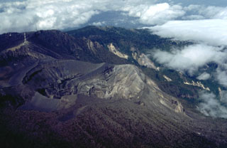 This view from the east shows the active 600-m-wide crater that has been the site of most of Irazú's historical eruptions. The smaller, shallow crater to the lower left is the Diego de la Haya crater.
 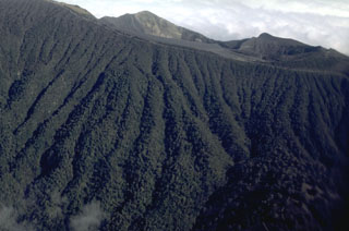 The upper southern flanks of Irazú contain abundant erosional gullies. The summit is just out of view at the upper right. The northern rim of the currently active summit crater is at the top of this photo, in the center. To the right is the northern rim of the older Diego de la Haya crater.
 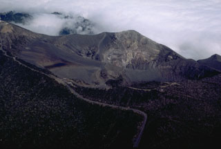 This view of Irazú from the SE shows the road leading to the summit (upper left) and principal crater (right center). The road winds 32 km up the flanks to the summit crater complex, a tourist attraction near the capital city of San José. The roughly 200-m-deep summit crater has been the source of most historical eruptions.
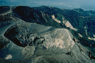 Irazú, Costa Rica's highest volcano, rises to 3432 m east of the capital city of San José. The volcano is vegetated to within a few hundred meters of its broad summit crater complex. At least 10 satellitic cones are located on the south flank of Irazú. The focus of eruptions at the summit crater complex has migrated to the west towards the historically active crater, which contains a small lake. Ashfall from its last major eruption during 1963-65 caused significant disruption to San José and surrounding areas.
 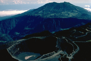 The foreground crater in this aerial photo from the SW is the principal summit crater of 3432-m-high Irazú volcano. The massive stratovolcano in the background is 3340-m-high Turrialba volcano. Roads of widely divergent quality lead to the summit craters of both these historically active volcanoes, the two highest in Costa Rica.
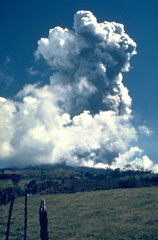 The first of several major eruptions of Irazú between 1963 and 1965 took place on 13 March 1963. These eruptions produced heavy ashfall over much of central Costa Rica, severely affecting agricultural areas and causing major economic problems. Lahars caused fatalities and destroyed hundreds of houses.
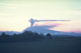 An ash plume above the summit of Irazú is seen in March 1963 from the old San José airport. Eruptions during 1963-65 were among the largest in historical time from the volcano. Intermittent mild-to-moderate explosive activity produced heavy ashfall that severely affected agricultural areas and caused economic disruption.
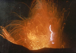 This photo captures volcanic lightning within incandescent ejecta from the Irazú summit crater in 1963. Intermittent ejection of ash, lapilli, blocks, and bombs took place for two years beginning from March 1963. Late in 1963 an ash plume reached 8 km above the vent in four minutes.
 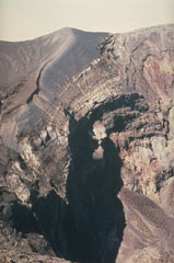 Frequent eruptions have kept the Irazú summit craters devoid of vegetation. The thick dark-gray ash and scoria units that form the crater walls were emplaced during the 1963-65 eruptions.
 The Cervantes lava flows formed this uneven terrain on the south flank of Irazú. This massive flow deposit originated from two vents, Cerro Pasquí and another to the NW, producing the eastern and western Cervantes flows, respectively. The former traveled about 10 km to the base of the volcano. These flows are geochemically different, with the 0.17 km3 western flow being basaltic in composition and the 0.9 km3 eastern flow basaltic andesite. Radiocarbon ages for the flows range between about 14,000 and 17,000 years ago.
 The two main summit craters of Irazú are seen here from the west in 1998. A lake fills the bottom of the main crater (Cráter Principal), with the older Diego de la Haya crater at the top of the photo.
  The Irazú main crater is about 700 m wide and 200 m deep. It is seen here in 1998 from the summit, with ash-covered Playa Hermosa (a largely buried older crater) to the lower right, and the edge of Diego de la Haya crater to the upper right.
  The infilled, 400 x 500 m wide Diego de la Haya crater in the background was the site of Irazú's first documented eruption in 1723. The eruption began on 16 February 1723, reached peak intensity in February and March, and continued sporadically until 11 December. Incandescent blocks and bombs were ejected, and ash fell on the cities of Cartago, San José, Barva, and Heredia. The active summit crater is to the lower left in this 1998 photo.
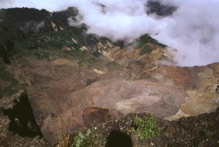 This area was impacted by an 8 December 1994 phreatic explosion is visible from the NW rim of Irazú's summit crater, seen here in 1998. The explosion originated from a geothermal area (lower right) on the upper NW flank and destroyed vegetation down to 2,500 m elevation. The explosion, which produced no juvenile material, created an irregular crater 60-80 m in diameter and sent ashfall to about 30 km distance. Landslides and lahars traveled down the Río Sucio drainage (right center).
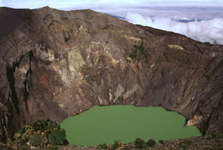 The Irazú summit crater is about 700 m wide and nearly 200 m deep and has been the source of most of Irazú's historical eruptions. Geothermal activity is frequently observed around of the lake, and the water color varies with changing atmospheric conditions.
 A lake occupies one of the Irazú summit craters (seen here from the southern crater rim in 1996), which has been the source of many recent eruptions. The first well-documented eruption of Irazú occurred in 1723, and frequent explosive eruptions have occurred since. Ashfall from its last major eruption during 1963-65 caused significant disruption to San José and surrounding areas.
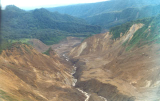 An avalanche produced during an 8 December 1994 phreatic explosion at Irazú traveled down the Río Sucio to the north, destroying trees high up the banks of the river. Associated lahars swept many kilometers farther down the river, which flows through the Cordillera Volcánica Central Forest Reserve. The explosion formed a new crater in a geothermal area north of the main crater.
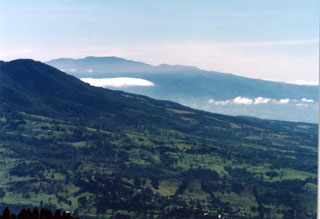 The southern flank of Barva is in the foreground of this photo, with Irazú massif to the SE in the background. One of the youngest lava flows on Barva, the Los Angeles flow, traveled down the south flank almost as far as the city of Heredia. Barva and Irazú are visible from the nation's capital city, San José out of view to the right. Irazú is sometimes known as the "Colossus" due to its size and occasionally destructive eruptions.
 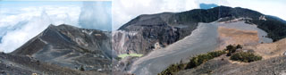 A panoramic view from the summit of Irazú volcano shows the E-W-trending summit crater complex. The main crater is partially filled by a lake in the center of the photo, the floor of the broad flat-bottomed Playa Hermosa crater at the right is covered by deposits of historical eruptions, and the Diego de la Haya crater lies in the right background.
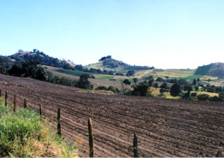 There is a group of scoria cones on the southern flank of Irazú near the road to the summit. Flank cones were the source of voluminous lava flows such as the roughly 1.2 km3 Cervantes flow, which traveled about 10 km down the SSE flank to the Río Reventazon at the base of the volcano.
 An ash plume above the Irazú summit crater is seen here in 1917 from the national theater in San José. All summit craters were reported to be active on 27 September 1917, after which activity steadily intensified. Ash fell in Curridabat on 18 November and again a month later, when ash also fell in Tres Ríos. On 6 January 1918 ashfall reached San José, Heredia, and Puriscal. Intermittent explosive activity continued until 1921, with an explosion on 30 November 1918 producing ashfall as far as Nicoya.
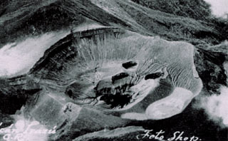 An aerial view shows the summit crater of Irazú volcano prior to the 1963 eruption, with the Diego de la Haya crater at the lower left and Playa Hermosa at the left-center. The floor of the main crater (Cráter Principal) contains several small explosion craters. The ridge on the right side of the crater floor is the remnant of the pyroclastic cone formed during the 1723 eruption. Repeated explosive eruptions during 1963-65 greatly modified the summit crater, and the individual vents seen here were merged into a single large crater.
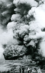 This 1964 photo shows visitors at the edge of the Irazú active crater; seven people were killed and many more injured by explosive ejecta in April and August of that year. Secondary lahars produced by the remobilization of thick ash deposits also caused fatalities. Over a 2-year period, 46 lahars occurred along the Río Reventado valley; one killed at least 20 people and destroyed 400 houses and some factories.
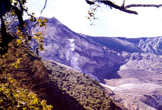 This view of the less-frequently seen northern side of Irazú's summit crater complex shows fumaroles rising from vents below a steep escarpment cutting the outer NW flank of the volcano's main crater (which lies behind the high point on the left horizon). This thermal area, known as Las Fumaroles, was the source of an explosive eruption in December 1994 that also produced an avalanche and mudflow down the Río Sucio, the valley at the lower right.
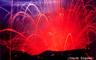 Strombolian explosions during the 1963-65 eruption ejected incandescent lava bombs from the crater, seen here in a time-lapse photo. Similar activity occurred in December 1963 and January 1964.
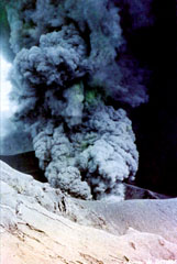 Intermittent explosive activity during the 1963-65 Irazú eruption cumulatively produced extensive ashfall that caused significant economic damage to San Jose and other populated areas of the Central Valley of Costa Rica. During the first weeks of January 1964 heavy ashfall was deposited as far away as Tamarindo beach on the Pacific coast and Lake Nicaragua, 180 km NE of the volcano.
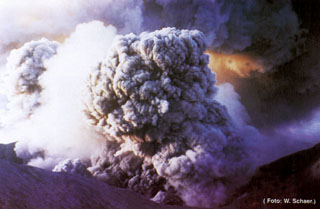 Ashfall from the 1963-65 eruption of Irazú affected both populated areas and agricultural lands. In the weeks following the beginning of the eruption on 13 March 1963 ashfall at times restricted visibility to 30 m in the capital city of San José, paralyzing traffic. Ashfall caused extensive damage to farmlands, resulting in the death of livestock. Remobilization of ash during the rainy season caused lahars that destroyed houses, roads, and bridges, and caused fatalities.
 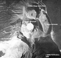 The Irazú summit crater complex is seen in this aerial view with north to the left. The Diego de la Haya crater is at the top and then to the main crater (Cráter Principal) contains a small lake. Playa Hermosa is a largely buried older crater. The road at the right leads to communication towers at the summit (lower right).
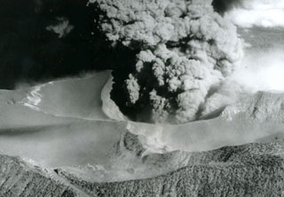 An ash plume erupts from the Irazú summit crater on 14 April 1964, about midway through a major explosive eruption that began in 1963. The ash-covered plateau to the left is Playa Hermosa, an older buried crater. The road to the summit is to the lower left. Heavy ashfall from the 1963-65 eruption was deposited across the Central Valley and caused major economic disruption.
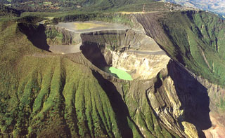 Several craters have formed at the summit of Irazú: the gray, flat floor of the Playa Hermosa crater, Irazú's main crater (center), and the Diego de la Haya crater (top left). A green lake fills the bottom of the main crater in this 1999 view, the source of most of Irazú's historical eruptions.
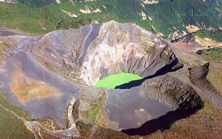 An aerial view from the SE looks down on the Irazú summit crater complex in 1999. Three craters are visible here, the 700-m-wide main crater with a green lake, the Diego de la Haya crater (lower right), and the older Playa Hermosa crater (lower left).
 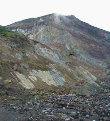 Hydrothermally altered rocks and lava flows are exposed in cliffs on the Irazú upper northern flank. Las Fumaroles (near top center), a thermal area below the cliffs, was the source of an explosive eruption in December 1994 that also produced an avalanche and lahar down the Río Sucio.
The maps shown below have been scanned from the GVP map archives and include the volcano on this page. Clicking on the small images will load the full 300 dpi map. Very small-scale maps (such as world maps) are not included. The maps database originated over 30 years ago, but was only recently updated and connected to our main database. We welcome users to tell us if they see incorrect information or other problems with the maps; please use the Contact GVP link at the bottom of the page to send us email.
The following 33 samples associated with this volcano can be found in the Smithsonian's NMNH Department of Mineral Sciences collections, and may be availble for research (contact the Rock and Ore Collections Manager). Catalog number links will open a window with more information.
| Catalog Number | Sample Description | Lava Source | Collection Date |
|---|---|---|---|
| NMNH 109392-41 | Volcanic Rock | -- | -- |
| NMNH 109392-42 | Volcanic Rock | -- | -- |
| NMNH 113067-1 | Basalt | -- | -- |
| NMNH 113067-2 | Aplite | -- | -- |
| NMNH 113437 | Basaltic Andesite | -- | -- |
| NMNH 113438 | Basaltic Andesite | -- | -- |
| NMNH 113439 | Basaltic Andesite | -- | -- |
| NMNH 113440 | Basaltic Andesite | -- | -- |
| NMNH 113441 | Basaltic Andesite | -- | -- |
| NMNH 113442 | Basaltic Andesite | -- | -- |
| NMNH 116066-503 | Tephra | -- | 24 May 1985 |
| NMNH 116066-504 | Tephra | -- | 24 May 1985 |
| NMNH 116066-505 | Tephra | -- | 24 May 1985 |
| NMNH 116066-506 | Tephra | -- | 24 May 1985 |
| NMNH 116066-507 | Tephra | -- | 24 May 1985 |
| NMNH 116066-508 | Tephra | -- | 24 May 1985 |
| NMNH 116066-509 | Volcanic Rock | -- | 24 May 1985 |
| NMNH 116066-834 | Tephra | -- | -- |
| NMNH 116066-835 | Tephra | -- | -- |
| NMNH 116066-836 | Tephra | -- | -- |
| NMNH 116066-837 | Tephra | -- | -- |
| NMNH 116066-838 | Tephra | -- | -- |
| NMNH 116066-839 | Tephra | -- | -- |
| NMNH 116066-840 | Tephra | -- | -- |
| NMNH 116066-841 | Tephra | -- | -- |
| NMNH 116066-842 | Tephra | -- | -- |
| NMNH 116066-843 | Tephra | -- | -- |
| NMNH 116066-844 | Tephra | -- | -- |
| NMNH 116066-845 | Tephra | -- | -- |
| NMNH 116066-846 | Tephra | -- | -- |
| NMNH 116066-847 | Tephra | -- | -- |
| NMNH 116066-848 | Tephra | -- | -- |
| NMNH 116066-849 | Tephra | -- | -- |
| Copernicus Browser | The Copernicus Browser replaced the Sentinel Hub Playground browser in 2023, to provide access to Earth observation archives from the Copernicus Data Space Ecosystem, the main distribution platform for data from the EU Copernicus missions. |
| MIROVA | Middle InfraRed Observation of Volcanic Activity (MIROVA) is a near real time volcanic hot-spot detection system based on the analysis of MODIS (Moderate Resolution Imaging Spectroradiometer) data. In particular, MIROVA uses the Middle InfraRed Radiation (MIR), measured over target volcanoes, in order to detect, locate and measure the heat radiation sourced from volcanic activity. |
| MODVOLC Thermal Alerts | Using infrared satellite Moderate Resolution Imaging Spectroradiometer (MODIS) data, scientists at the Hawai'i Institute of Geophysics and Planetology, University of Hawai'i, developed an automated system called MODVOLC to map thermal hot-spots in near real time. For each MODIS image, the algorithm automatically scans each 1 km pixel within it to check for high-temperature hot-spots. When one is found the date, time, location, and intensity are recorded. MODIS looks at every square km of the Earth every 48 hours, once during the day and once during the night, and the presence of two MODIS sensors in space allows at least four hot-spot observations every two days. Each day updated global maps are compiled to display the locations of all hot spots detected in the previous 24 hours. There is a drop-down list with volcano names which allow users to 'zoom-in' and examine the distribution of hot-spots at a variety of spatial scales. |
|
WOVOdat
Single Volcano View Temporal Evolution of Unrest Side by Side Volcanoes |
WOVOdat is a database of volcanic unrest; instrumentally and visually recorded changes in seismicity, ground deformation, gas emission, and other parameters from their normal baselines. It is sponsored by the World Organization of Volcano Observatories (WOVO) and presently hosted at the Earth Observatory of Singapore.
GVMID Data on Volcano Monitoring Infrastructure The Global Volcano Monitoring Infrastructure Database GVMID, is aimed at documenting and improving capabilities of volcano monitoring from the ground and space. GVMID should provide a snapshot and baseline view of the techniques and instrumentation that are in place at various volcanoes, which can be use by volcano observatories as reference to setup new monitoring system or improving networks at a specific volcano. These data will allow identification of what monitoring gaps exist, which can be then targeted by remote sensing infrastructure and future instrument deployments. |
| Volcanic Hazard Maps | The IAVCEI Commission on Volcanic Hazards and Risk has a Volcanic Hazard Maps database designed to serve as a resource for hazard mappers (or other interested parties) to explore how common issues in hazard map development have been addressed at different volcanoes, in different countries, for different hazards, and for different intended audiences. In addition to the comprehensive, searchable Volcanic Hazard Maps Database, this website contains information about diversity of volcanic hazard maps, illustrated using examples from the database. This site is for educational purposes related to volcanic hazard maps. Hazard maps found on this website should not be used for emergency purposes. For the most recent, official hazard map for a particular volcano, please seek out the proper institutional authorities on the matter. |
| IRIS seismic stations/networks | Incorporated Research Institutions for Seismology (IRIS) Data Services map showing the location of seismic stations from all available networks (permanent or temporary) within a radius of 0.18° (about 20 km at mid-latitudes) from the given location of Irazú. Users can customize a variety of filters and options in the left panel. Note that if there are no stations are known the map will default to show the entire world with a "No data matched request" error notice. |
| UNAVCO GPS/GNSS stations | Geodetic Data Services map from UNAVCO showing the location of GPS/GNSS stations from all available networks (permanent or temporary) within a radius of 20 km from the given location of Irazú. Users can customize the data search based on station or network names, location, and time window. Requires Adobe Flash Player. |
| DECADE Data | The DECADE portal, still in the developmental stage, serves as an example of the proposed interoperability between The Smithsonian Institution's Global Volcanism Program, the Mapping Gas Emissions (MaGa) Database, and the EarthChem Geochemical Portal. The Deep Earth Carbon Degassing (DECADE) initiative seeks to use new and established technologies to determine accurate global fluxes of volcanic CO2 to the atmosphere, but installing CO2 monitoring networks on 20 of the world's 150 most actively degassing volcanoes. The group uses related laboratory-based studies (direct gas sampling and analysis, melt inclusions) to provide new data for direct degassing of deep earth carbon to the atmosphere. |
| Large Eruptions of Irazú | Information about large Quaternary eruptions (VEI >= 4) is cataloged in the Large Magnitude Explosive Volcanic Eruptions (LaMEVE) database of the Volcano Global Risk Identification and Analysis Project (VOGRIPA). |
| EarthChem | EarthChem develops and maintains databases, software, and services that support the preservation, discovery, access and analysis of geochemical data, and facilitate their integration with the broad array of other available earth science parameters. EarthChem is operated by a joint team of disciplinary scientists, data scientists, data managers and information technology developers who are part of the NSF-funded data facility Integrated Earth Data Applications (IEDA). IEDA is a collaborative effort of EarthChem and the Marine Geoscience Data System (MGDS). |

