
Smithsonian Institution / US Geological Survey
Weekly Volcanic Activity Report, 17 January-23 January 2007
Managing Editor: Sally Sennert
Please cite this report as:
Global Volcanism Program, 2007. Report on Ulawun (Papua New Guinea) (Sennert, S, ed.). Weekly Volcanic Activity Report, 17 January-23 January 2007. Smithsonian Institution and US Geological Survey. https://volcano.si.edu/showreport.cfm?gvpvar=GVP.WVAR20070117-252120
Based on a pilot report, the Darwin VAAC reported that an ash plume from Ulawun rose to an altitude of 2.4 km (8,000 ft) a.s.l. on 18 January and drifted SW.
Source: Darwin Volcanic Ash Advisory Centre (VAAC)
Geological Summary. The symmetrical basaltic-to-andesitic Ulawun stratovolcano is the highest volcano of the Bismarck arc, and one of Papua New Guinea's most frequently active. The volcano, also known as the Father, rises above the N coast of the island of New Britain across a low saddle NE of Bamus volcano, the South Son. The upper 1,000 m is unvegetated. A prominent E-W escarpment on the south may be the result of large-scale slumping. Satellitic cones occupy the NW and E flanks. A steep-walled valley cuts the NW side, and a flank lava-flow complex lies to the south of this valley. Historical eruptions date back to the beginning of the 18th century. Twentieth-century eruptions were mildly explosive until 1967, but after 1970 several larger eruptions produced lava flows and basaltic pyroclastic flows, greatly modifying the summit crater.


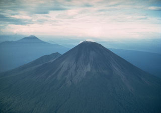 Ulawun