
Smithsonian Institution / US Geological Survey
Weekly Volcanic Activity Report, 1 July-7 July 2009
Managing Editor: Sally Sennert
Please cite this report as:
Global Volcanism Program, 2009. Report on Santa Maria (Guatemala) (Sennert, S, ed.). Weekly Volcanic Activity Report, 1 July-7 July 2009. Smithsonian Institution and US Geological Survey. https://volcano.si.edu/showreport.cfm?gvpvar=GVP.WVAR20090701-342030
INSIVUMEH reported that on 2 July lahars descended the Nimá I and Nimá II rivers on the S flank of Santa María's Santiaguito lava dome complex, carrying tree branches and blocks 50-75 cm in diameter. The lahars were 15 and 20 m wide. On 6 July, explosions produced ash plumes that rose to altitudes of 2.8-3.2 km (9,200-10,500 ft) a.s.l. and drifted W.
Source: Instituto Nacional de Sismologia, Vulcanologia, Meteorologia, e Hidrologia (INSIVUMEH)
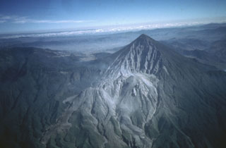
Geological Summary. Symmetrical, forest-covered Santa María volcano is part of a chain of large stratovolcanoes that rise above the Pacific coastal plain of Guatemala. The sharp-topped, conical profile is cut on the SW flank by a 1.5-km-wide crater. The oval-shaped crater extends from just below the summit to the lower flank, and was formed during a catastrophic eruption in 1902. The renowned Plinian eruption of 1902 that devastated much of SW Guatemala followed a long repose period after construction of the large basaltic andesite stratovolcano. The massive dacitic Santiaguito lava-dome complex has been growing at the base of the 1902 crater since 1922. Compound dome growth at Santiaguito has occurred episodically from four vents, with activity progressing E towards the most recent, Caliente. Dome growth has been accompanied by almost continuous minor explosions, with periodic lava extrusion, larger explosions, pyroclastic flows, and lahars.


 Santa Maria