
The Instituto Nacional de Sismología, Vulcanología, Meteorología e Hidrología (INSIVUMEH) reported high levels of ongoing eruptive activity at Santa Maria’s Santiaguito dome complex during 16-23 September, with continuing lava extrusion at Caliente dome. Daily explosions, 2-6 per hour when reported, generated gas-and-ash plumes that rose 700-1,000 m above the dome and drifted in multiple directions. Effusion of blocky lava and collapses of previous deposits produced block avalanches that descended mainly the W and SW flanks; the collapsed material produced short pyroclastic density currents during 22-23 September. Incandescence during dark hours was visible from Caliente dome and block avalanches. Special reports issued at 1305 on 16 September and at 1337 on 20 September noted that heavy rainfall generated hot lahars in the Cabello de Ángel drainage (SE). The lahars were a mixture of water and sediments, along with tree trunks, branches, and blocks up to 3 m in diameter, and a sulfur odor. Hot lahars moving down the Tambor drainage (SSW) were noted in special reports issued at 1317 on 16 September, at 1345 on 18 September, and at 1346 on 20 September. These lahars were also a mixture of water and sediments, with tree trunks, branches, and blocks up to 1 m in diameter, and a sulfur odor.
Source: Instituto Nacional de Sismologia, Vulcanologia, Meteorologia, e Hidrologia (INSIVUMEH)
Continuing lava effusion, explosions, ash plumes, and pyroclastic flows during August-November 2023
The Santiaguito lava dome complex of Guatemala’s Santa María volcano has been actively erupting since 1922. The lava dome complex lies within a large crater on the SW flank of Santa María that was formed during the 1902 eruption. Ash explosions, pyroclastic flows, and lava flows have emerged from Caliente, the youngest of the four vents in the complex for more than 40 years. A lava dome that appeared within Caliente’s summit crater in October 2016 has continued to grow, producing frequent block avalanches down the flanks. More recently, activity has been characterized by frequent explosions, lava flows, ash plumes, and pyroclastic flows (BGVN 48:09). This report covers activity during August through November 2023 based on information from Guatemala's INSIVUMEH (Instituto Nacional de Sismologia, Vulcanologia, Meterologia e Hidrologia) and various satellite data.
Activity during August consisted of weak-to-moderate explosions, avalanches of material, gas-and-ash plumes, and incandescence observed at night and in the early morning. Weak degassing plumes rose 300-600 m above the crater. Frequent explosions were detected at a rate of 1-2 per hour, which produced gas-and-ash plumes that rose 200-1,000 m above the crater and drifted W, NW, SW, S, E, and NE. Two active lava flows continued mainly in the Zanjón Seco (SW) and San Isidro (W) drainages. Incandescent block avalanches and occasional block-and-ash flows were reported on the W, S, E, SE, and SW flanks, as well as on the lava flows. On 26 and 29 August, fine ash plumes rose to 3.5 km altitude and drifted E and NE, causing ashfall in Belén (10 km S) and Calaguache (9 km S), as well as Santa María de Jesús (5 km SE) on 29 August.
Daily degassing, weak-to-moderate explosions, gas-and-ash plumes, and nighttime and early morning incandescence in the upper part of the dome continued during September. Explosions occurred at a rate of 1-2 per hour. Gas-and-ash plumes rose 200-1,000 m above the crater and drifted SW, W, SE, and NW. Block avalanches descended the SW, S, SE, and E flanks, often reaching the base of the Caliente dome. These avalanches were sometimes accompanied by short pyroclastic flows, resulting in fires in some vegetated areas. Block-and-ash flows descended all flanks of the Caliente dome on 16 and 24 September following the eruption of gas-and-ash plumes that rose 700-1,000 m above the crater. Gray ash was primarily deposited in the drainages.
Continuous gas-and-steam emissions occurred in October, along with weak-to-moderate explosions, block avalanches, crater incandescence, and an active lava flow on the WSW flank. Explosions occurred at a rate of 1-4 per hour, that generated gas-and-ash plumes rose 200-1,000 m above the crater and drifted in different directions. Block avalanches traveled down the SW, S, SE, and E flanks, sometimes accompanied by small pyroclastic flows. On 21 and 25 October as many as 50 explosions occurred over the course of 24 hours.
Similar activity persisted during November, with frequent explosions, crater incandescence, and block avalanches. The active lava flow persisted on the WSW flank. Weak-to-moderate explosions occurred at a rate of 1-4 per hour. Incandescence was observed at night and in the early morning. Gas-and-ash emissions rose 700-900 m above the crater and drifted W, SW, S, and NW. Block avalanches were reported on the SW, W, S, SE, and E flanks, which deposited gray ash material in the drainages, sometimes reaching the base of the Caliente dome. Those avalanches were sometimes accompanied by small pyroclastic flows that reached the base of the dome on the W, SW, and S flanks. Ashfall was reported in Las Marías (10 km S), El Viejo Palmar (12 km SSW), El Patrocinio, and San Marcos (8 km SW) on 18 and 22 November. On 26 and 30 November ashfall was reported in San Marcos and Loma Linda Palajunoj (7 km SW).
The MIROVA (Middle InfraRed Observation of Volcanic Activity) graph showed frequent moderate-power thermal anomalies during the reporting period (figure 140). A total of 26 MODVOLC thermal alerts were issued on 6, 7, 7, 15, 16, and 21 August, 15 and 23 September, 19, 26, 27, and 29 October, and 2, 7, 11, 27, 28, and 29 November. Clouds covered the summit of the volcano on most days, so thermal anomalies could not be identified in most Sentinel infrared satellite images.
 |
Figure 140. Moderate-power thermal anomalies were frequently detected at Santa María during August through November 2023, as shown on this MIROVA graph (Log Radiative Power). Courtesy of MIROVA. |
Information Contacts: Instituto Nacional de Sismologia, Vulcanologia, Meteorologia e Hydrologia (INSIVUMEH), Unit of Volcanology, Geologic Department of Investigation and Services, 7a Av. 14-57, Zona 13, Guatemala City, Guatemala (URL: http://www.insivumeh.gob.gt/); MIROVA (Middle InfraRed Observation of Volcanic Activity), a collaborative project between the Universities of Turin and Florence (Italy) supported by the Centre for Volcanic Risk of the Italian Civil Protection Department (URL: http://www.mirovaweb.it/); Hawai'i Institute of Geophysics and Planetology (HIGP) - MODVOLC Thermal Alerts System, School of Ocean and Earth Science and Technology (SOEST), Univ. of Hawai'i, 2525 Correa Road, Honolulu, HI 96822, USA (URL: http://modis.higp.hawaii.edu/); Copernicus Browser, Copernicus Data Space Ecosystem, European Space Agency (URL: https://dataspace.copernicus.eu/browser/).
2025: January
| February
| March
| April
| May
| June
| July
| August
| September
2024: January
| February
| March
| April
| May
| June
| July
| August
| September
| October
| November
2023: January
| February
| March
| April
| May
| June
| July
| August
| September
| October
| November
| December
2022: January
| February
| March
| April
| May
| June
| August
| October
| November
2021: January
| February
| March
| May
| June
| July
| August
| September
| October
| December
2020: January
| March
| April
| May
| June
| July
| August
| October
| November
| December
2019: February
| March
| May
| June
| August
| October
| November
2018: February
| May
| June
| July
| August
| September
| October
| November
2017: February
| May
| July
| October
2016: January
| February
| March
| April
| May
| June
| July
| August
| September
| October
| November
2015: January
| March
| April
| May
| July
| August
| September
| October
2014: January
| February
| March
| April
| May
| June
| July
| August
| September
| October
2013: January
| February
| March
| April
| May
| June
| July
| August
| September
2012: January
| February
| March
| April
| May
| June
| July
| August
| September
| October
| November
| December
2011: January
| February
| March
| April
| May
| June
| July
| September
| October
| November
| December
2010: January
| February
| March
| April
| May
| June
| July
| August
| September
| October
| November
| December
2009: January
| February
| March
| April
| June
| July
| August
| September
| October
| November
| December
2008: January
| February
| March
| April
| May
| June
| July
| August
| September
| November
| December
2007: January
| February
| March
| April
| May
| June
| July
| August
| September
| October
| December
2006: January
| February
| March
| April
| June
| August
| September
| October
| November
| December
2005: March
| April
| May
| June
| July
| September
| October
| November
| December
2004: January
| February
| March
| April
| May
| June
| July
| August
| September
| October
| November
| December
2003: February
| July
| August
| September
| October
| November
| December
2002: March
| May
| August
The Instituto Nacional de Sismología, Vulcanología, Meteorología e Hidrología (INSIVUMEH) reported high levels of ongoing eruptive activity at Santa Maria’s Santiaguito dome complex during 16-23 September, with continuing lava extrusion at Caliente dome. Daily explosions, 2-6 per hour when reported, generated gas-and-ash plumes that rose 700-1,000 m above the dome and drifted in multiple directions. Effusion of blocky lava and collapses of previous deposits produced block avalanches that descended mainly the W and SW flanks; the collapsed material produced short pyroclastic density currents during 22-23 September. Incandescence during dark hours was visible from Caliente dome and block avalanches. Special reports issued at 1305 on 16 September and at 1337 on 20 September noted that heavy rainfall generated hot lahars in the Cabello de Ángel drainage (SE). The lahars were a mixture of water and sediments, along with tree trunks, branches, and blocks up to 3 m in diameter, and a sulfur odor. Hot lahars moving down the Tambor drainage (SSW) were noted in special reports issued at 1317 on 16 September, at 1345 on 18 September, and at 1346 on 20 September. These lahars were also a mixture of water and sediments, with tree trunks, branches, and blocks up to 1 m in diameter, and a sulfur odor.
Source: Instituto Nacional de Sismologia, Vulcanologia, Meteorologia, e Hidrologia (INSIVUMEH)
The Instituto Nacional de Sismología, Vulcanología, Meteorología e Hidrología (INSIVUMEH) reported high levels of ongoing eruptive activity at Santa Maria’s Santiaguito dome complex during 2-9 September, with continuing lava extrusion at Caliente dome. Daily explosions, 1-3 per hour when reported, generated gas-and-ash plumes that rose as high as 1 km above the dome and drifted as far as 20 km W, WSW, and SW. Effusion of blocky lava produced incandescent block avalanches that descended mainly the W and SW flanks; the collapsed material occasionally produced short pyroclastic flows that reached the base of the cone. Incandescence was visible at Caliente dome mostly during dark hours. During the early afternoon of 3 September heavy rainfall generated a minor lahar in the Cabello de Ángel drainage (SSW) that carried blocks up to 3 m in diameter mixed with fine sediment, tree trunks, and branches. Another lahar descended the Tambor drainage (SSW) that carried blocks up to 1 m in diameter mixed with fine sediment, tree trunks, and branches. Both lahars were hot and had a sulfur odor. Ashfall was reported in local areas on several days downwind including San Marcos Palajunoj (8 km SW) and Loma Linda (7 km W).
Source: Instituto Nacional de Sismologia, Vulcanologia, Meteorologia, e Hidrologia (INSIVUMEH)
The Instituto Nacional de Sismología, Vulcanología, Meteorología e Hidrología (INSIVUMEH) reported high levels of ongoing eruptive activity at Santa Maria’s Santiaguito dome complex during 12-19 August, with continuing lava extrusion at Caliente dome. Daily explosions, 1-2 per hour when reported, generated gas-and-ash plumes that rose 800-900 m above the dome and drifted W and SW. Effusion of blocky lava and collapses of previous deposits produced block avalanches that descended mainly the W and SW flanks; the collapsed material produced short pyroclastic flows that descended the SW and S flanks during 12-13 August. Incandescence during dark hours was visible from Caliente dome and block avalanches. During the early afternoon of 12 August heavy rainfall generated lahars in the Tambor drainage (SSW) that carried blocks up to 1 m in diameter mixed with fine sediment, tree trunks, and branches. The lahars were hot and had a sulfur odor. Material accumulated at the W crater rim began collapsing at 1630 on 16 August, generating pyroclastic flows that descended the San Isidro drainage as far as 4 km. Associated gas-and-ash plumes rose 1 km and drifted 30-60 km W and SW, causing abundant ashfall in San Marcos Palajunoj (8 km SW), Loma Linda (7 km W), San Martín Sacatepéquez (11 km NW), and Colomba (18 km WSW) and minor ashfall in more distance areas including La Reforma (28 km WNW), El Quetzal (26 km WNW), Coatepeque (31 km W), and Pajapita (50 km W). In the early evening of 16 August minor lahars descended the Zanjón Seco (SW) and Tambor River channels.
Source: Instituto Nacional de Sismologia, Vulcanologia, Meteorologia, e Hidrologia (INSIVUMEH)
The Instituto Nacional de Sismología, Vulcanología, Meteorología e Hidrología (INSIVUMEH) reported strong eruptive activity continuing at Santa Maria’s Santiaguito dome complex during 30 July-5 August, including lava extrusion at Caliente dome. Daily explosions, 1-2 per hour when reported, generated gas-and-ash plumes that rose as high as 1 km above the dome and drifted W. Effusion of blocky lava and collapses of previous deposits produced block avalanches that descended multiple flanks; the collapsed material sometimes produced pyroclastic flows that reached the base of the volcano. Incandescence was visible at Caliente dome mostly during dark hours. Minor ashfall was reported in communities to the S and SW during 1 and 3-5 August.
Source: Instituto Nacional de Sismologia, Vulcanologia, Meteorologia, e Hidrologia (INSIVUMEH)
The Instituto Nacional de Sismología, Vulcanología, Meteorología e Hidrología (INSIVUMEH) reported high levels of ongoing eruptive activity at Santa Maria’s Santiaguito dome complex during 22-29 July with continuing lava extrusion at Caliente dome. Daily explosions, 1-5 per hour when reported, generated gas-and-ash plumes that rose as high as 1 km above the dome and drifted as far as 20 km W and SW. Effusion of blocky lava and collapses of previous deposits produced block avalanches that descended multiple flanks; the collapsed material sometimes produced pyroclastic flows that reached the base of the volcano. Incandescence was visible at Caliente dome mostly during dark hours. On 25 July a minor lahar descended the Cabello de Ángel river, a tributary of the Nimá I, on the E flank, carrying tree trunks, branches, and volcanic blocks up to 3 m in diameter. The lahar was hot and has a sulfur odor. Minor ashfall was reported in communities to the S and SW during 25-26 July.
Source: Instituto Nacional de Sismologia, Vulcanologia, Meteorologia, e Hidrologia (INSIVUMEH)
The Instituto Nacional de Sismología, Vulcanología, Meteorología e Hidrología (INSIVUMEH) reported high levels of ongoing eruptive activity at Santa Maria’s Santiaguito dome complex during 8-15 July with continuing lava extrusion at Caliente dome. Daily explosions, 1-2 per hour when reported, generated gas-and-ash plumes that rose as high as 1 km above the dome and drifted as far as 30 km W and SW. Effusion of blocky lava and collapses of material produced block avalanches that descended multiple flanks; the collapsed material sometimes produced short pyroclastic flows that reached the base of the volcano. Incandescence was visible at Caliente dome and upper part of the W flank lava flow. Minor ashfall was reported in communities surrounding the volcano during 8-9 July inclsuing San Marcos (10 km SW), Loma Linda (7 km W), Palajunoj (17 km SSW).
Source: Instituto Nacional de Sismologia, Vulcanologia, Meteorologia, e Hidrologia (INSIVUMEH)
The Instituto Nacional de Sismología, Vulcanología, Meteorología e Hidrología (INSIVUMEH) reported high levels of ongoing eruptive activity at Santa Maria’s Santiaguito dome complex during 24 June-1 July with continuing lava extrusion at Caliente dome. Daily explosions, 1-2 per hour when reported, generated gas-and-ash plumes that rose as high as 1.2 km above the dome and drifted as far as 30 km N, NW, W, and SW. Effusion of blocky lava and collapses of material produced block avalanches that descended multiple flanks; the collapsed material sometimes produced short pyroclastic flows that reached the base of Caliente cone. Incandescence was visible at Caliente dome and upper part of the W flank lava flow. Minor ashfall was reported in communities surrounding the volcano during 25-26 June and in San Marcos (10 km SW), Loma Linda (7 km W), Palajunoj (17 km SSW), and other areas downwind during 29-30 June.
Source: Instituto Nacional de Sismologia, Vulcanologia, Meteorologia, e Hidrologia (INSIVUMEH)
The Instituto Nacional de Sismología, Vulcanología, Meteorología e Hidrología (INSIVUMEH) reported ongoing eruptive activity at Santa Maria’s Santiaguito dome complex during 10-17 June with continuing lava extrusion at Caliente dome. Daily weak and moderate explosions, as many as five per hour when reported, generated gas-and-ash plumes that rose as high as 1 km above the dome and drifted downwind. Effusion of blocky lava and collapses of material produced block avalanches that descended multiple flanks. Incandescence was visible at Caliente dome and the upper part of the lava flow on the SW flank.
Source: Instituto Nacional de Sismologia, Vulcanologia, Meteorologia, e Hidrologia (INSIVUMEH)
The Instituto Nacional de Sismología, Vulcanología, Meteorología e Hidrología (INSIVUMEH) reported high levels of ongoing eruptive activity at Santa Maria’s Santiaguito dome complex during 27 May-3 June with continuing lava extrusion at Caliente dome. Daily weak and moderate explosions, as many as three per hour when reported, generated gas-and-ash plumes that rose as high as 1 km above the dome and drifted as far as 40 km in various directions. Effusion of blocky lava and collapses of material produced block avalanches that descended multiple flanks; the collapsed material sometimes produced short pyroclastic flows that reached the base of Caliente cone. Incandescence was visible at Caliente dome and upper part of the SW flank lava flow. Ashfall was reported in areas downwind including San Marcos (10 km SW), Loma Linda (7 km W), Palajunoj (17 km SSW), Finca Monte Bello (6 km WSW), and Monte María during 27-31 May.
Source: Instituto Nacional de Sismologia, Vulcanologia, Meteorologia, e Hidrologia (INSIVUMEH)
The Instituto Nacional de Sismología, Vulcanología, Meteorología e Hidrología (INSIVUMEH) reported ongoing eruptive activity at Santa Maria’s Santiaguito dome complex during 6-13 May with continuing lava extrusion at Caliente dome. Daily explosions, as many as five per hour when reported, sometimes generated gas-and-ash plumes that rose as high as 1 km above the dome and possibly drifted as far as 15 km E, S, SW, and W. Effusion of blocky lava and collapses of material produced block avalanches that descended multiple flanks; the collapsed material sometimes produced short pyroclastic flows. Incandescence was visible at Caliente dome and upper part of the SW flank lava flow. During the evening of 10 May heavy rainfall generated lahars in the Tambor drainage (SSW) that carried blocks up to 1 m in diameter mixed with fine sediment, tree trunks, and branches. Ashfall was reported in San Marcos (10 km SW), Loma Linda (7 km W), and Palajunoj (17 km SSW) during 12-13 May.
Source: Instituto Nacional de Sismologia, Vulcanologia, Meteorologia, e Hidrologia (INSIVUMEH)
The Instituto Nacional de Sismología, Vulcanología, Meteorología e Hidrología (INSIVUMEH) reported ongoing eruptive activity at Santa Maria’s Santiaguito dome complex during 9-15 April with continuing lava extrusion at Caliente dome. Daily explosions, as many as seven per hour when reported, generated gas-and-ash plumes that rose as high as 1.2 km above the dome and possibly drifted as far as 40 km S, E, SE, and NE. Effusion of blocky lava and collapses of material produced block avalanches that mainly descended the S, SW, and W flanks. Collapsed material sometimes produced short pyroclastic flows that descended the flanks in all directions. Incandescence was visible at Caliente dome and upper part of the SW flank lava flow. On 9 April heavy rainfall generated lahars in the Tambor drainage (SSW) that carried blocks up to 1 m in diameter mixed with fine sediment, tree trunks, and branches. A sulfurous odor was also reported. Ashfall was reported from Nuevo Palmar (12 km SSW) and Pueblo Nuevo to San Felipe (15 km SSW) and Loma Linda (7 km W) during 11-12 April and in Las Marías (9.5 km S), Calaguaché (9 km S), and Belén (10 km S) during 12-13 April.
Source: Instituto Nacional de Sismologia, Vulcanologia, Meteorologia, e Hidrologia (INSIVUMEH)
The Instituto Nacional de Sismología, Vulcanología, Meteorología e Hidrología (INSIVUMEH) reported ongoing, high-level eruptive activity at Santa Maria’s Santiaguito dome complex during 2-8 April with continuing lava extrusion at Caliente dome. Daily explosions, as many as five per hour when reported, generated gas-and-ash plumes that rose as high as 1.2 km above the dome and possibly drifted as far as 40 km N, NW, W, and SW. Effusion of blocky lava and collapses of material produced block avalanches that were sometimes heard several kilometers away; these mainly descended the SE, S, SW, and W flanks. Collapsed material sometimes produced short pyroclastic flows that descended the flanks in all directions. Incandescence was visible at Caliente dome and upper part of the SW flank lava flow. Ashfall was forecast for areas downwind on most days. Ashfall was reported in Finca El Patrocinio (8 km SW), San Marcos (10 km SW), Loma Linda (7 km W), Palajunoj (17 km SSW), Llanos de Pinal, and other nearby communities during 2-3 April, from Calahuaché (8 km SSE) to Viejo Palmar (11 km S) and Loma Linda during 6-7 April, and forecasted for areas downwind on most other days.
Source: Instituto Nacional de Sismologia, Vulcanologia, Meteorologia, e Hidrologia (INSIVUMEH)
The Instituto Nacional de Sismología, Vulcanología, Meteorología e Hidrología (INSIVUMEH) reported ongoing, high-level eruptive activity at Santa Maria’s Santiaguito dome complex during 11-18 March with continuing lava extrusion at Caliente dome. Daily explosions, as many as seven per hour when reported, generated gas-and-ash plumes that rose as high as 1.2 km above the dome and possibly drifted as far as 40 km S, SW, W, and NE. Effusion of blocky lava and collapses of material produced block avalanches that were sometimes heard several kilometers away; these mainly descended the SW and S flanks. Collapsed material sometimes produced short pyroclastic flows that descended the flanks in all directions. Incandescence was visible at the crater and upper part of the SW flank lava flow. Ashfall was forecast for areas downwind on most days.
Source: Instituto Nacional de Sismologia, Vulcanologia, Meteorologia, e Hidrologia (INSIVUMEH)
The Instituto Nacional de Sismología, Vulcanología, Meteorología e Hidrología (INSIVUMEH) reported ongoing eruptive activity at Santa Maria’s Santiaguito dome complex during 18-25 February with continuing lava extrusion at Caliente dome. Daily explosions, as many as seven per hour when reported, generated gas-and-ash plumes that rose as high as 1.2 km above the dome and drifted as far as 40 km W, SW, S, and SE. Effusion of blocky lava and collapses of material produced daily block avalanches that were sometimes heard several kilometers away; these mainly descended the SW and S flanks, but occasionally went SE. Collapsed material sometimes produced short pyroclastic flows. Incandescence was visible at the crater and upper part of the SW flank lava flow. During 19-20 February ashfall was reported in Las Marías (9.5 km S), Finca El Patrocinio (8 km SW), San Marcos (10 km SW), Loma Linda Palajunoj (7 km SW), and other nearby communities, and forecasted for areas downwind on most days.
Source: Instituto Nacional de Sismologia, Vulcanologia, Meteorologia, e Hidrologia (INSIVUMEH)
The Instituto Nacional de Sismología, Vulcanología, Meteorología e Hidrología (INSIVUMEH) reported ongoing eruptive activity at Santa Maria’s Santiaguito dome complex during 4-11 February with continuing lava extrusion at Caliente dome. Daily explosions, as many as seven per hour when reported, generated gas-and-ash plumes that rose as high as 1.2 km above the dome and drifted SW and W. Effusion of blocky lava and collapses of material produced daily block avalanches that were sometimes heard several kilometers away; these mainly descended the SW and S flanks, but occasionally went SE and E. Incandescence was visible at the crater and upper part of the WSW flank lava flow, and occasionally from ejected incandescent blocks. During 9-10 February ashfall was reported at Finca Monte Bello (6 km WSW) and surrounding areas. Explosions and collapses generated short pyroclastic flows during 10-11 February.
Source: Instituto Nacional de Sismologia, Vulcanologia, Meteorologia, e Hidrologia (INSIVUMEH)
The Instituto Nacional de Sismología, Vulcanología, Meteorología e Hidrología (INSIVUMEH) reported ongoing eruptive activity at Santa Maria’s Santiaguito dome complex during 22-28 January with continuing lava extrusion at Caliente dome. Daily explosions, as many as 6 per hour when reported, generated gas-and-ash plumes that rose as high as 1.2 km above the dome and drifted SW, W, and NW. Effusion of blocky lava and collapses of material produced block avalanches that descended the flanks in multiple directions almost daily; the avalanches could sometimes be heard in areas several kilometers away. Collapsed material produced short pyroclastic flows on 26 and 27 January. Incandescence at the crater was sometimes visible during dark hours. On 28 January ashfall was reported in Las Marías (9.5 km S), Finca El Patrocinio (8 km SW), San Marcos (10 km SW), Loma Linda Palajunoj (7 km SW), and other nearby communities, and forecasted for areas downwind on most days.
Source: Instituto Nacional de Sismologia, Vulcanologia, Meteorologia, e Hidrologia (INSIVUMEH)
The Instituto Nacional de Sismologia, Vulcanologia, Meteorologia, e Hidrologia (INSIVUMEH) reported ongoing eruptive activity at Santa Maria’s Santiaguito dome complex during 7-14 January with continuing lava extrusion at Caliente dome. Daily explosions, as many as 11 per hour when reported, generated gas-and-ash plumes that rose as high as 1.2 km above the dome and drifted as far as 40 km NW, W, SW, S, and SE. Effusion of blocky lava and collapses of material produced block avalanches that descended the flanks in multiple directions almost daily; the avalanches could sometimes be heard in areas several kilometers away. Collapsed material produced short pyroclastic flows on a few of the days. Incandescence at the crater was sometimes visible during dark hours. Ashfall was reported during 10-11 January in areas downwind including San Marcos (10 km SW), Finca El Patrocinio (9 km SSW), Loma Linda Palajunoj (7 km SW), Llanos de Pinal, and surrounding areas, and forecasted for areas downwind on most of the other days.
Source: Instituto Nacional de Sismologia, Vulcanologia, Meteorologia, e Hidrologia (INSIVUMEH)
The Instituto Nacional de Sismologia, Vulcanologia, Meteorologia, e Hidrologia (INSIVUMEH) reported ongoing eruptive activity at Santa Maria’s Santiaguito dome complex during 19 November-3 December with continuing lava extrusion at Caliente dome. Daily explosions, as many as 11 per hour when reported, generated gas-and-ash plumes that rose as high as 900 m above the dome and drifted W, SW, S, and SE. Effusion of blocky lava and collapses of material produced block avalanches that descended the SE, S, and SW flanks; the avalanches could sometimes be heard in areas several kilometers away. Collapsed material produced short pyroclastic flows on a few of the days. Incandescence at the crater was sometimes visible during dark hours. Ashfall was reported on a few of the days in areas downwind including on farms to the SW, Monte Bello, Las Marías (10 km S), San Marcos (10 km SW), El Faro (7 km S), Finca El Patrocinio (9 km SSW), San Felipe Retalhuleu (27 km SSW), Paulownia, Palajunoj (17 km SSW), and surrounding areas.
Source: Instituto Nacional de Sismologia, Vulcanologia, Meteorologia, e Hidrologia (INSIVUMEH)
Instituto Nacional de Sismologia, Vulcanologia, Meteorologia, e Hidrologia (INSIVUMEH) reported ongoing eruptive activity at Santa Maria’s Santiaguito dome complex during 12-19 November with continuing lava extrusion at Caliente dome. Daily explosions (a few per hour) generated gas-and-ash plumes that rose as high as 900 m above the dome and drifted in several directions; cloudy weather during 17-18 November prevented visual observations, though explosions and avalanches were heard. Effusion of blocky lava and collapses of material produced block avalanches that descended the SE, S, and SW flanks. Collapsed material produced short pyroclastic flows during 14-16 November. Incandescence was sometimes visible during dark hours from avalanches of material at the dome as well as explosions. Ashfall was reported in areas downwind during 15-16 November including San Marcos (8 km SW), Lome Linda Palajunoj (7 km SW), Las Marías (10 km S), Calaguaché (9 km S), and Belén (10 km S). On 19 November ashfall was reported in Santa María de Jesús (5 km SE), La Muralla (8 km ENE), Zunil (10 km NE), and surrounding areas.
Source: Instituto Nacional de Sismologia, Vulcanologia, Meteorologia, e Hidrologia (INSIVUMEH)
Instituto Nacional de Sismologia, Vulcanologia, Meteorologia, e Hidrologia (INSIVUMEH) reported ongoing eruptive activity at Santa Maria’s Santiaguito cone during 30 October and 5 November with continuing lava extrusion at Caliente dome. Daily explosions (a few per hour) generated gas-and-ash plumes that rose as high as 1 km above the dome and drifted several directions. The explosions and emissions generated short pyroclastic density currents (PDC) during 30-31 October. Effusion of blocky lava and collapses of material produced block avalanches that descended the flanks. Incandescence was sometimes visible during dark hours from avalanches of material at the dome as well as explosions. Ashfall was reported in San Marcos (8 km SW), Lome Linda Palajunoj (7 km SW), Finca El Patrocinio on 31 October.
Source: Instituto Nacional de Sismologia, Vulcanologia, Meteorologia, e Hidrologia (INSIVUMEH)
Instituto Nacional de Sismologia, Vulcanologia, Meteorologia, e Hidrologia (INSIVUMEH) reported ongoing eruptive activity at Santa Maria’s Santiaguito cone during 16-21 October with continuing lava extrusion at Caliente dome. Daily explosions (a few per hour) generated gas-and-ash plumes that rose as high as 900 m above the summit and drifted mainly NW, S, and SW. Effusion of blocky lava and collapses of material produced block avalanches that descended the flanks. Incandescence was sometimes visible during dark hours from avalanches of material at the dome as well as explosions. Ashfall was reported in San Marcos (8 km SW) on 19 October.
Source: Instituto Nacional de Sismologia, Vulcanologia, Meteorologia, e Hidrologia (INSIVUMEH)
Instituto Nacional de Sismologia, Vulcanologia, Meteorologia, e Hidrologia (INSIVUMEH) reported ongoing eruptive activity at Santa Maria’s Santiaguito cone during 1-8 October with continuing lava extrusion at Caliente dome. Daily explosions (a few per hour) generated gas-and-ash plumes that rose as high as 900 m above the summit and drifted mainly SW, W, N, and NE. Effusion of blocky lava and collapses of material produced block avalanches and occasional short pyroclastic flows that descended the flanks. Incandescence was sometimes visible during dark hours from avalanches of material at the dome as well as explosions. Ashfall was reported in Santa María de Jesús (5 km SE), Calaguaché (9 km S), Belén (10 km S), and other areas downwind during 6-7 October.
Source: Instituto Nacional de Sismologia, Vulcanologia, Meteorologia, e Hidrologia (INSIVUMEH)
Instituto Nacional de Sismologia, Vulcanologia, Meteorologia, e Hidrologia (INSIVUMEH) reported ongoing eruptive activity at Santa Maria’s Santiaguito lava-dome complex during 17-24 September with lava extrusion, block collapses, and avalanches at the Caliente dome complex. Effusion of blocky lava produced block avalanches on the dome’s flanks and occasional short pyroclastic flows that descended the W, SW, and S flanks; the deposits created promontories of unstable material near the top of the 2022 lava flow located in the Zanjón Seco and San Isidro drainages. Incandescence was visible during dark hours from avalanches of material at the dome as well as explosions. Daily explosions (a few per hour) generated gas-and-ash plumes that rose as high as 800 m above the summit and sometimes drifted mainly W and SW. Ashfall was reported in San Marcos (8 km SW), Loma Linda Palajunoj (7 km SW), and surrounding areas during 17-18 September.
Source: Instituto Nacional de Sismologia, Vulcanologia, Meteorologia, e Hidrologia (INSIVUMEH)
INSIVUMEH reported ongoing eruptive activity at Santa Maria’s Santiaguito lava-dome complex during 3-10 September with lava extrusion, block collapses, and avalanches at the Caliente dome complex. Effusion of blocky lava produced block avalanches on the dome’s flanks and occasional short pyroclastic flows that descended multiple flanks; the deposits created promontories of unstable material near the top of the 2022 lava flow located in the Zanjón Seco and San Isidro drainages. Incandescence from avalanches of material at the dome as well as explosions was visible during dark hours. Daily explosions (a few per hour) generated gas-and-ash plumes that rose 500-900 m above the summit and drifted mainly N, W, and SW. Ashfall was reported in San Marcos (8 km SW) and Loma Linda Palajunoj (7 km SW) during 5-6 September. Ash fell on the flanks and in surrounding areas during 7-8 September.
Source: Instituto Nacional de Sismologia, Vulcanologia, Meteorologia, e Hidrologia (INSIVUMEH)
Instituto Nacional de Sismología, Vulcanologia, Meteorologia e Hidrología (INSIVUMEH) reported that high-level eruptive activity continued at Santa Maria’s Santiaguito lava-dome complex during 13-20 August with lava extrusion, block collapses, and avalanches at the Caliente dome complex. The continuous effusion of blocky lava produced block avalanches on the dome’s flanks and occasional short-range pyroclastic flows that descended multiple flanks. Accumulated material formed a promontory upslope of the 2022 lava flows in the Zanjón Seco (SW) and San Isidro (W) drainages. During most nights and early mornings incandescence was visible around Caliente dome. Daily explosions generated gas-and-ash plumes that rose 700-900 m above the summit and drifted mainly NW, W, and SW. Ashfall was reported in areas downwind includinh Monte Claro (S) during 14-15 August and in San Marcos (8 km SW) and Loma Linda Palajunoj (7 km SW) during 18-19 August. On 18 August a lahar descended the Tambor river in the SSW sector of the volcano carrying sediment, tree trunks, branches, and volcanic blocks up to 1 m in diameter. The lahar was hot and had a sulfur odor.
Source: Instituto Nacional de Sismologia, Vulcanologia, Meteorologia, e Hidrologia (INSIVUMEH)
Instituto Nacional de Sismología, Vulcanologia, Meteorologia e Hidrología (INSIVUMEH) reported that eruptive activity continued at Santa Maria’s Santiaguito lava-dome complex during 31 July-6 August with lava extrusion, block collapses, and avalanches at the Caliente dome complex. The continuous effusion of blocky lava produced block avalanches on the dome’s flanks and occasional short pyroclastic flows that descended multiple flanks. During most nights and early mornings incandescence was visible around Caliente dome, along the upper parts of the lava flow, and at several locations on other flanks. Daily explosions (a few per hour on most days) generated gas-and-ash plumes that rose 400-800 m above the summit and drifted NW, W, and SW. Ashfall was reported in San Marcos (8 km SW) and Loma Linda Palajunoj (7 km SW) on 1 and 4 August.
Source: Instituto Nacional de Sismologia, Vulcanologia, Meteorologia, e Hidrologia (INSIVUMEH)
Instituto Nacional de Sismología, Vulcanologia, Meteorologia e Hidrología (INSIVUMEH) reported that high-level eruptive activity continued at Santa Maria’s Santiaguito lava-dome complex during 10-16 July with lava extrusion, block collapses, and avalanches at the Caliente dome complex. The continuous effusion of blocky lava produced block avalanches on the dome’s flanks and occasional short-range pyroclastic flows that descended multiple flanks. During most nights and early mornings incandescence was visible around Caliente dome and along the upper parts of the lava flow on the WSW flank. Lava extrusion fed the upper parts of the lava flow, and block avalanches occasionally traveled over the lava flow. Daily explosions (a few per hour on most days) generated gas-and-ash plumes that rose 700-900 m above the summit and drifted mainly NW, W, and SW. Ashfall was reported in San Marcos (8 km SW) and Loma Linda Palajunoj (7 km SW) on 14 July. On 10 July a lahar descended the Tambor river in the SSW sector of the volcano carrying tree trunks, branches, and volcanic blocks up to 1 m in diameter. Weather conditions sometimes prevented visual observations.
Source: Instituto Nacional de Sismologia, Vulcanologia, Meteorologia, e Hidrologia (INSIVUMEH)
INSIVUMEH reported that high-level eruptive activity continued at Santa Maria’s Santiaguito lava-dome complex during 25 June-2 July with lava extrusion, block collapses, and avalanches at the Caliente dome complex. The continuous effusion of blocky lava produced block avalanches on the dome’s flanks and occasional short pyroclastic flows that descended multiple flanks, creating promontories of unstable material. Incandescence from avalanches of material at the dome as well as explosions was visible during most nights and early mornings, and occasional incandescence was also present along the upper parts of the lava flow on the WSW flank. Lava extrusion fed the upper parts of the lava flow, and block avalanches occasionally traveled over the lava flow. Daily explosions (a few per hour on most days) generated gas-and-ash plumes that rose 700-900 m above the summit and drifted mainly NW, W, and SW. Ashfall was reported in San Marcos (8 km SW) and Loma Linda Palajunoj (7 km SW) during 26-27 June. Rain caused steam to rise from the lava flows in the Zanjón Seco (SW) and San Isidro (W) drainages during 29-30 June. On 1 July a lahar descended the Cabello de Ángel river, a tributary of the Nimá I, on the SE flank, carrying tree trunks, branches, and volcanic blocks up to 1 m in diameter. Weather conditions sometimes prevented visual observations.
Source: Instituto Nacional de Sismologia, Vulcanologia, Meteorologia, e Hidrologia (INSIVUMEH)
INSIVUMEH reported that eruptive activity continued at Santa Maria’s Santiaguito lava-dome complex during 10-18 June with lava extrusion, block collapses, and avalanches at the Caliente dome. Sometimes the avalanches are audible several kilometers away. Incandescence from avalanches of material at the dome as well as explosions was visible during most nights and early mornings, and occasional incandescence was also present along the upper parts of the lava flow on the WSW flank. Lava extrusion fed the upper parts of the lava flow, and block avalanches occasionally traveled over the lava flow. Daily explosions (a few per hour on most days) generated gas-and-ash plumes that rose 700-900 m above the summit and drifted in multiple directions. The explosions produced block avalanches on the dome’s flanks and generated occasional short-range pyroclastic flows that descended multiple flanks. On 10 June a minor lahar descended the Cabello de Ángel river, a tributary of the Nimá I, on the E flank, possibly carrying tree trunks, branches, and volcanic blocks up to 1 m in diameter. Weather conditions sometimes prevented visual observations.
Source: Instituto Nacional de Sismologia, Vulcanologia, Meteorologia, e Hidrologia (INSIVUMEH)
INSIVUMEH reported that eruptive activity continued at Santa Maria’s Santiaguito lava-dome complex during 21-28 May with continuing lava extrusion and block collapses and avalanches at the Caliente dome. Sometimes the avalanches are audible several kilometers away. Incandescence from the dome was visible during most nights and early mornings, and occasional incandescence was also present along the upper parts of the lava flow on the WSW flank. Daily explosions (a few per hour) generated gas-and-ash plumes that rose 700-1,400 m above the summit and drifted E, SE, SW, and W. The explosions produced block avalanches on the dome’s flanks and generated occasional short-range pyroclastic flows that descended multiple flanks. The ash plumes caused hazy conditions around the volcano during 22-23 and 27-28 May.
Source: Instituto Nacional de Sismologia, Vulcanologia, Meteorologia, e Hidrologia (INSIVUMEH)
INSIVUMEH reported that eruptive activity continued at Santa Maria’s Santiaguito lava-dome complex during 30 April-7 May with a lava extrusion and blocks avalanches at the Caliente dome. Incandescence from the dome was visible during most nights and early mornings, and occasional incandescence was also present along the upper parts of the lava flow on the WSW flank. Daily explosions (1-5 per hour on most days) generated gas-and-ash plumes that rose 600-1,400 m above the summit and drifted as far as 25 km W, SW, S. The explosions produced block avalanches on the dome’s flanks and generated occasional short-range pyroclastic flows that descended multiple flanks. Block avalanches from collapses at the dome and at the margins of the upper part of the lava flow were sometimes audible several kilometers from the volcano. Ashfall caused hazy conditions around the volcano during 2-3 April. Minor ashfall was reported in San Marcos Palajunoj (8 km SW) and Finca Pauwlonias (S) during 3-4 and 6-7 April.
Source: Instituto Nacional de Sismologia, Vulcanologia, Meteorologia, e Hidrologia (INSIVUMEH)
INSIVUMEH reported that eruptive activity continued at Santa Maria’s Santiaguito lava-dome complex during 1-9 April with a lava extrusion and avalanches at the Caliente dome. Incandescence from the dome was visible during most nights and early mornings, and occasional incandescence was also present along the upper parts of the lava flow on the WSW, S, and SE flanks. Daily explosions (1-7 per hour on some days) generated gas-and-ash plumes that mainly rose 600-900 m above the summit and drifted as far as 20 km NW, W, and SW. The explosions produced block avalanches on the dome’s flanks and generated occasional, short-range pyroclastic flows that mainly descended E, SE, and SW flanks. Block avalanches from the dome and the margins of the upper part of the lava flow were also sometimes visible. Rumblings were occasionally heard. Ashfall was reported in San Marcos Palajunoj (8 km SW), Loma Linda (7 km W), Llanos de Pinal, and other nearby communities during 4-5 April.
Source: Instituto Nacional de Sismologia, Vulcanologia, Meteorologia, e Hidrologia (INSIVUMEH)
INSIVUMEH reported that eruptive activity continued at Santa Maria’s Santiaguito lava dome complex during 20-26 March with a lava extrusion and avalanches at the Caliente dome. Incandescence from the dome was visible during most nights and early mornings, and occasional incandescence was also present along the upper WSW flank lava flow. Daily explosions generated ash, gas, and steam plumes that rose as high as 900 m above the summit and drifted multiple directions on most days, and on 20 March rose 2.2 km above the summit. The explosions occurred at rates between 1 and 7 per hour that generated block avalanches on the dome’s flanks and occasional short pyroclastic flows that descended multiple flanks. Sometimes the block avalanches were accompanied by rumbling sounds. On 21 and 22 March ashfall was reported in Loma Linda (7 km W), San Marcos Palajunoj (8 km SW) and other communities in this area; ash caused hazy conditions around the volcano on 24 and 25 March.
Source: Instituto Nacional de Sismologia, Vulcanologia, Meteorologia, e Hidrologia (INSIVUMEH)
INSIVUMEH reported that eruptive activity continued at Santa Maria’s Santiaguito lava dome complex during 6-12 March with a lava extrusion and avalanches at the Caliente dome. Incandescence from the dome was visible during most nights and early mornings, and occasional incandescence was also present along the upper part of the lava flow on the WSW flank. Daily explosions generated gas-and-ash plumes that rose 600-900 m above the summit and drifted NW, W, SW, and S; the explosions occurred at a rate of 1-8 per hour on at least a few of the days where reported. The explosions produced block avalanches on the dome’s flanks and generated occasional, short-range pyroclastic flows that mainly descended the W, S, and E flanks. Block avalanches from the dome and the margins of the upper part of the lava flow were also sometimes visible. Rumblings were heard occasionally. Ashfall was reported in Belén (10 km S), Calaguache (9 km S), and Las Marías (10 km S) during 5-6 March and in San Marcos Palajunoj (8 km SW), Loma Linda (7 km W), and other nearby communities during 6-7 and 10-12 March; ash caused hazy conditions around the volcano during 8-9 March.
Source: Instituto Nacional de Sismologia, Vulcanologia, Meteorologia, e Hidrologia (INSIVUMEH)
INSIVUMEH reported that eruptive activity continued at Santa Maria’s Santiaguito lava dome complex during 20-27 February with a lava extrusion at the Caliente dome. Incandescence from the dome was visible during most nights and early mornings, and occasional incandescence was also present along the upper part of the SW-flank lava flow. Daily explosions generated gas-and-ash plumes that rose 600-900 m above the summit and drifted W, SW, and S; the explosions occurred at a rate of 1-7 per hour on at least a few of the days. The explosions produced block avalanches on the dome’s W, SW, S, and E flanks and generated occasional, short-range pyroclastic flows that descended multiple flanks. Block avalanches from the margins of the upper part of the lava flow on the WSW flank were also occasionally visible. Ashfall occurred in Loma Linda (7 km W) and San Marcos Palajunoj (8 km SW) during 20-21 February and caused hazy conditions around the volcano during 22-23 February.
Source: Instituto Nacional de Sismologia, Vulcanologia, Meteorologia, e Hidrologia (INSIVUMEH)
INSIVUMEH reported that eruptive activity continued at Santa Maria’s Santiaguito lava dome complex during 7-13 February with lava extrusion at the Caliente dome. Weak, moderate, and sometimes abundant degassing was observed daily and rose as high as 200 m above the crater. Incandescence from the dome and upper lava flow was visible during most nights and early mornings. Daily explosions generated gas-and-ash plumes that rose as high as 900 m above the dome and drifted S, SW, W, and NW. The explosions produced block avalanches around the dome and along the SE, S, SW, and W flanks. Explosions generated short-range pyroclastic flows that descended the E and SE flanks on 9 February and the S, SW, and W flanks on 12 February. On 8 February ashfall was observed in the direct vicinity of the volcano.
Source: Instituto Nacional de Sismologia, Vulcanologia, Meteorologia, e Hidrologia (INSIVUMEH)
INSIVUMEH reported that eruptive activity continued at Santa Maria’s Santiaguito lava dome complex during 23-31 January with a lava extrusion at the Caliente dome. Daily reports were not available on 29 and 30 January. Incandescence from the dome was visible during most nights and early mornings. Explosions occurring at a rate of 1-6 per hour on most days generated gas-and-ash plumes that rose 600-900 m above the dome and drifted mainly NW, W, and SW. The explosions produced block avalanches on the dome’s W, SW, S, and E flanks and generated occasional, short-range pyroclastic flows that predominantly descended the W, SW, and S flanks. Block avalanches were visible from the margins of the upper part of the lava flow on the SW flank. Ashfall occurred in Loma Linda (7 km W) and San Marcos Palajunoj (8 km SW) during 25-26 January.
Source: Instituto Nacional de Sismologia, Vulcanologia, Meteorologia, e Hidrologia (INSIVUMEH)
INSIVUMEH reported that eruptive activity continued at Santa Maria’s Santiaguito lava dome complex during 26 December 2023-2 January 2024 with lava extrusion at Caliente dome. Incandescence from the dome was visible during most nights and early mornings. Explosions occurring at a rate of 1-4 per hour on most days generated gas-and-ash plumes that rose as high as 1 km above the dome and drifted as far as 25 km in multiple directions. The explosions produced block avalanches on the dome’s S, SE, and E flanks in addition to generating short-range pyroclastic flows on the W, SW, and S flanks. Ashfall was reported in areas downwind including Llanos del Pinal (6 km NNE), Santa María de Jesús (5 km SE), Calaguaché (9 km S), Loma Linda (7 km W), and Quetzaltenango (18 km WNW) on a few of the days. During 31 December-1 January block-and-ash or pyroclastic flows traveled as far as 3 km down the flank.
Source: Instituto Nacional de Sismologia, Vulcanologia, Meteorologia, e Hidrologia (INSIVUMEH)
INSIVUMEH reported that eruptive activity continued at Santa Maria’s Santiaguito lava dome complex during 29 November-5 December. Extrusion at the El Caliente dome continued, with growth concentrated toward the WSW. Weak to moderate degassing was observed daily; gas-and-steam plumes rose to 300 m above the lava dome and drifted SW and W. Daily explosions produced gas-and-ash plumes to 3.2-3.5 km a.s.l. (700-1,000 m above the dome complex) that drifted S, SW, and NW; sometimes areas around the volcano appeared hazy due to ashfall. Ashfall was reported in Loma Linda (6 km WSW), San Marcos (8 km SW), and nearby farms on 30 November and 4 December. Block avalanches descended the SE, S, and SW flanks, and some were accompanied by pyroclastic flows (PDCs). On 30 November and 5 December PDCs nearly reached the base of the edifice. Incandescence from the lava dome and flow was observed in the crater and along the flanks during most nights and early mornings.
Source: Instituto Nacional de Sismologia, Vulcanologia, Meteorologia, e Hidrologia (INSIVUMEH)
INSIVUMEH reported that eruptive activity continued at Santa Maria’s Santiaguito lava dome complex during 8-14 November. Extrusion at the El Caliente dome continued, with growth concentrated toward the WSW. Degassing activity was observed during most days; white and blue gas-and-steam plumes rose to 400 m above the lava dome and drifted SW. Daily weak to moderate explosions produced gas-and-ash plumes to 3.2-3.5 km a.s.l. (700-1,000 m above the dome complex) that drifted SW and W; sometimes areas around the volcano appeared hazy due to ashfall. Block avalanches descended the SE, S, and SW flanks, and some were accompanied by small pyroclastic flows. Incandescence from the lava dome and flow was observed in the crater during most nights and early mornings.
Source: Instituto Nacional de Sismologia, Vulcanologia, Meteorologia, e Hidrologia (INSIVUMEH)
INSIVUMEH reported that eruptive activity continued at Santa Maria’s Santiaguito lava dome complex during 24-31 October with lava extrusion at Caliente dome. Incandescence from the dome was visible during most nights and early mornings, and occasionally from the lava flow on the upper WSW flank. Daily weak-to-moderate explosions occurring at a rate of 1-4 per hour generated gas-and-ash plumes that rose 700-1,000 m above the dome and drifted W and SW. Explosions produced block-and-ash flows that descended the SW, S, SE, and E flanks of Caliente dome and were occasionally accompanied by small pyroclastic flows.
Source: Instituto Nacional de Sismologia, Vulcanologia, Meteorologia, e Hidrologia (INSIVUMEH)
INSIVUMEH reported that eruptive activity continued at Santa Maria’s Santiaguito lava dome complex during 11-17 October with lava extrusion at Caliente dome. Incandescence from the dome was visible during most nights and early mornings, and occasionally from the lava flow on the WSW flank. Explosions triggered incandescent avalanches that descended the dome’s flanks in all directions. Block avalanches descended drainages on the SW, S, SE, and E flanks; during 12-13 and 16-17 October the avalanches were occasionally accompanied by small pyroclastic flows. Daily weak-to-moderate explosions generated gas-and-ash plumes that rose 800-1,000 m above the dome and drifted in multiple directions. During 13-14 October explosions occurred at a rate of 1-2 per hour and produced block-and-ash flows that descended the SW, S, and SE flanks and left gray ash deposits.
Source: Instituto Nacional de Sismologia, Vulcanologia, Meteorologia, e Hidrologia (INSIVUMEH)
INSIVUMEH reported that eruptive activity continued at Santa Maria’s Santiaguito lava dome complex during 26 September-3 October. Incandescence from Caliente dome was visible during most nights and early mornings, and occasionally from the lava flow on the SW flank. Lava extrusion continued and generated block avalanches on the SW, S, and E flanks. Daily weak-to-moderate explosions generated gas-and-ash plumes that rose 700-1,000 m above the dome and drifted mainly W and SW. Explosions triggered incandescent avalanches that descended the dome’s flanks in all directions. A special bulletin issued at 1300 on 27 September described a hot lahar with a sulfur odor that descended the Zanjón Seco drainage on the SW flank carrying blocks 1-2 m in diameter. About 40 minutes later a viscous lahar descended the Cabello de Ángel river, a tributary of the Nimá I, on the E flank, carrying volcanic blocks up to 1 m in diameter, tree trunks, and branches. During 29-30 September explosions occurred at a rate of 1-2 per hour and produced block-and-ash flows that descended the W and SW flanks and left deposits of gray ash. Block avalanches descended the SW, S, and SE flanks during 30 September-1 October and occasionally produced small pyroclastic flows.
Source: Instituto Nacional de Sismologia, Vulcanologia, Meteorologia, e Hidrologia (INSIVUMEH)
INSIVUMEH reported that eruptive activity continued at Santa Maria’s Santiaguito lava dome complex during 12-19 September. Incandescence from the dome was visible during most nights and early mornings, and occasionally from the lava flow on the WSW flank. Lava extrusion continued. Daily weak-to-moderate explosions generated gas-and-ash plumes that rose 900-1,000 m above the dome and drifted NW, W, and SW. Some explosions triggered incandescent avalanches that descended the dome’s flanks in all directions, and occasionally into drainages on the S, SE, and E flanks. Deposits from block-and-ash-flows accumulated on top of the lava flows in the Zanjón, Seco, and San Isidro drainages.
Source: Instituto Nacional de Sismologia, Vulcanologia, Meteorologia, e Hidrologia (INSIVUMEH)
INSIVUMEH reported that eruptive activity continued at Santa Maria’s Santiaguito lava dome complex during 23-29 August. Incandescence from the dome was visible during most nights and early mornings, and occasionally from the SW lava flow. Lava extrusion continued and caused dome collapses and occasional short pyroclastic flows. Lava flows remained active in the Zanjón, Seco, and San Isidro drainages. Daily weak-to-moderate explosions generated gas-and-ash plumes that rose 700-1,000 m above the dome and drifted in multiple directions. Some explosions also triggered incandescent avalanches that descended the dome’s flanks in all directions, and into the Zanjón, Seco, and San Isidro drainages. Ashfall was reported in Belén (10 km S), Calaguache (9 km S), Santa María de Jesús (5 km SE) during 25-26 and 28-29 August.
Source: Instituto Nacional de Sismologia, Vulcanologia, Meteorologia, e Hidrologia (INSIVUMEH)
INSIVUMEH reported that eruptive activity continued at Santa Maria’s Santiaguito lava dome complex during 9-15 August. Incandescence from the dome was visible during most nights and early mornings, and occasionally from the SW lava flow. Lava extrusion continued and formed a more prominent high point in the middle of the dome that was the main source of collapses and occasional short pyroclastic flows. Daily weak-to-moderate explosions generated gas-and-ash plumes that rose 700-1,000 m above the dome and drifted NW, W, and SW. Explosions also triggered incandescent avalanches that descended the dome’s flanks in all directions, and into the Zanjón, Seco, and San Isidro drainages. Incandescence was observed at the crater and along lava flow margins during the night and early morning.
Source: Instituto Nacional de Sismologia, Vulcanologia, Meteorologia, e Hidrologia (INSIVUMEH)
INSIVUMEH reported that eruptive activity continued at Santa Maria’s Santiaguito lava dome complex during 26 July through 1 August. Weak degassing was reported 500-700 m above the dome. Daily weak to moderate explosions generated gas-and-ash plumes 200-1,000 m above the dome, which drifted NW, W, and SW, and triggered incandescent avalanches down the W, S, E, and SE flanks. Lava effusion at Caliente dome fed a lava flow on the WSW flank, and occasionally produced both avalanches and pyroclastic flows that traveled short distances down the W, S, and E flanks, especially moving toward the Zanjón Seco and San Isidro drainages on the W and SW flanks. Incandescence was observed at the crater and along lava flow margins during the night and early morning.
Source: Instituto Nacional de Sismologia, Vulcanologia, Meteorologia, e Hidrologia (INSIVUMEH)
INSIVUMEH reported that eruptive activity continued at Santa Maria’s Santiaguito lava dome complex during 5-11 July. Lava effusion at Caliente dome fed lava flows, and occasionally produced both avalanches and pyroclastic flows that traveled short distances down the S, SW, and W flanks. Daily weak and sometimes moderate explosions ejected ash plumes as high as 900 m above the dome that drifted W and NW, and triggered avalanches down the E, SE, and S flanks. Incandescence was observed at the crater and along lava flow margins during most nights and early mornings.
Source: Instituto Nacional de Sismologia, Vulcanologia, Meteorologia, e Hidrologia (INSIVUMEH)
INSIVUMEH reported that the eruption at Santa Maria’s Santiaguito lava dome complex continued during 27 June-4 July. Lava dome effusion generated avalanches, pyroclastic density currents (PDC) on all flanks, and fed active lava flows. Daily weak-to-moderate explosions also caused avalanches on all flanks. Explosive activity was highest during 28-29 June with 40 events that produced W- and NW-drifting ash plumes. Almost daily emissions of steam, gas, and sometimes ash rose as high as 1 km above the dome and drifted in multiple directions. Incandescence at the crater and along lava flow margins was visible during most nights and early mornings.
Source: Instituto Nacional de Sismologia, Vulcanologia, Meteorologia, e Hidrologia (INSIVUMEH)
INSIVUMEH reported that the eruption at Santa Maria’s Santiaguito lava dome complex continued during 20-27 June, with effusion of lava flows, explosions, and avalanches. Dome growth sometimes produced avalanches and short pyroclastic flows that traveled down the S, SW, and W flanks. Weak and moderate explosions were recorded daily. Explosions also triggered dome collapses, resulting in weak and moderate debris avalanches that descended the flanks in many directions. Incandescence at the crater and along lava flow margins was visible during most nights and early mornings. During 20-21 June ash-and-gas plumes rose 800 m and drifted W and SW. On 23 June a lahar descended the Río Cabello de Ángel, a tributary of the Nimá I and Samalá rivers on the E flank. The lahar consisted of a mixture of fine volcanic material, water, volcanic blocks up to 1 m in diameter, and tree trunks and branches.
Source: Instituto Nacional de Sismologia, Vulcanologia, Meteorologia, e Hidrologia (INSIVUMEH)
INSIVUMEH reported that the eruption at Santa María’s Santiaguito lava-dome complex continued during 31 May-6 June. Effusion from the Caliente dome complex fed lava flows that descended the San Isidro and Zanjón Seco drainages on the W and SW flanks; the main lava flow was 4.3 km long and remained active. Avalanches of material from the growing dome and occasional explosions descended all flanks of the dome, and avalanches from the margins of lava flows descended the S and SW flanks. Incandescence from the dome and lava flows was visible during the nights and early mornings. An average of 1-2 explosions per hour were recorded on most days, generating ash-and-steam plumes that rose up to 1 km above the dome and on some days drifted S and SE.
Source: Instituto Nacional de Sismologia, Vulcanologia, Meteorologia, e Hidrologia (INSIVUMEH)
INSIVUMEH reported that the eruption at Santa María’s Santiaguito lava-dome complex continued during 16-23 May. Effusion from the Caliente dome complex fed lava flows that descended the San Isidro and Zanjón Seco drainages on the W and SW flanks; the main lava flow was 4.3 km long and remained active. Avalanches of material from the growing dome and occasional explosions descended all sides of the dome and avalanches from the lava flow descended the S and SW flanks. Explosions generated gas, steam, and ash plumes that drifted S and SW on a few days. Incandescence from the dome and lava flows was visible during the nights and early mornings. An average of 40 explosions per day were recorded during 21-22 May, generating ash plumes that rose up to 1 km above the dome and drifted SW.
Source: Instituto Nacional de Sismologia, Vulcanologia, Meteorologia, e Hidrologia (INSIVUMEH)
INSIVUMEH reported that the eruption at Santa María’s Santiaguito lava-dome complex continued during 10-16 May. Effusion from the Caliente dome complex fed lava flows that descended the San Isidro and Zanjón Seco drainages on the W and SW flanks; the main lava flow was 4.3 km long and remained active. Daily weak-to-moderate explosions generated gas, steam, and ash plumes that generally rose up to 800 m above the crater and drifted SE, S, SW, and W. Explosions were sometimes accompanied by block-and-ash flows that descended multiple flanks of the dome. Incandescence from the dome and lava flows was visible during the nights and early mornings. An average of 40 explosions per day were recorded during 9-10 and 13-14 May, generating ash plumes that rose up to 1 km above the dome and drifted S and SW. Ashfall was reported in Fincas El Patrocinio, El Faro (7 km S), Las Marías (10 km S), and others nearby on 10 May.
Source: Instituto Nacional de Sismologia, Vulcanologia, Meteorologia, e Hidrologia (INSIVUMEH)
INSIVUMEH reported that the eruption at Santa María’s Santiaguito lava-dome complex continued during 2-9 May. Effusion from the Caliente dome complex fed lava flows that descended the San Isidro and Zanjón Seco drainages on the W and SW flanks; the main lava flow was 4.3 km long and remained active. Daily weak-to-moderate explosions generated ash-and-steam plumes that generally rose as high as 800 m and drifted SW. The explosions were also accompanied by block-and-ash flows that descended multiple flanks of the dome. Incandescence from the dome and the lava flows was visible each morning and night. Avalanches of material from the lava-flow front and margins caused ash plumes around the flanks. Activity during 5-6 May was characterized by high levels of extrusive and explosive activity; 40 explosions were recorded, producing ash plumes that rose 3.5 km above the dome and drifted SW. Ashfall was reported in San Marcos Palajunoj (8 km SW), Loma Linda (7 km W), and other nearby communities. During 6-7 May quiet rumbling sounds were heard on nearby farms. Residents were warned to stay 6 km away from the lava-dome complex.
Source: Instituto Nacional de Sismologia, Vulcanologia, Meteorologia, e Hidrologia (INSIVUMEH)
INSIVUMEH reported that the eruption at Santa María’s Santiaguito lava-dome complex continued during 26 April-2 May. Effusion from the Caliente dome complex fed lava flows that descended the San Isidro and Zanjón Seco drainages on the W and SW flanks; the main lava flow was 4.3 km long and remained active. Daily weak-to-moderate explosions generated ash-and-steam plumes that rose as high as 1 km above the dome and drifted W and SW. The explosions were also accompanied by block-and-ash flows that descended multiple flanks of the dome. Avalanches of material were also generated from the lava-flow front and margins. During 28-29 April quiet rumbling sounds were barely heard on nearby farms. Incandescence from the dome and the lava flows was visible nightly. On 28 April a lahar descended the Cabello de Angel River, a tributary of the Nimá I and Samalá rivers, on the E flank and was registered by the nearby seismic stations. The lahar consisted of volcanic material, water, volcanic blocks up to 1 m in diameter, and tree trunks and branches. On 30 April at 0920 a moderate explosion generated a pyroclastic flow that traveled 5 km SW and produced an ash cloud that rose 100 m along the flow. Seismic data confirmed that the event lasted 40 minutes.
Source: Instituto Nacional de Sismologia, Vulcanologia, Meteorologia, e Hidrologia (INSIVUMEH)
INSIVUMEH reported that the eruption at Santa María’s Santiaguito lava-dome complex continued during 18-25 April. Effusion from the Caliente dome complex fed lava flows that descended the San Isidro and Zanjón Seco drainages on the W and SW flanks; the main lava flow was 4.3 km long and remained active. Incandescence from the dome and the lava flows was frequently visible at night. Daily avalanches descended multiple flanks of the dome and were also occasionally generated from the lava-flow front and margins. Daily weak or weak-to-moderate explosions recorded by the seismic network generated ash plumes that rose as high as 1 km above the complex and drifted mainly S and SW. During 18-19 April ash fall was reported in Finca El Faro (6.7 km S). On 21 April quiet rumbling sounds were barely heard on nearby farms. Residents were reminded to stay away from the lava flow and at least 6 km away from the dome complex.
Source: Instituto Nacional de Sismologia, Vulcanologia, Meteorologia, e Hidrologia (INSIVUMEH)
INSIVUMEH reported that the eruption at Santa María’s Santiaguito lava-dome complex continued during 12-18 April. Effusion from the Caliente dome complex fed lava flows that descended the San Isidro and Zanjón Seco drainages on the W and SW flanks; the main lava flow was 4.3 km long and remained active. Incandescence from the dome and the lava flows was frequently visible at night. Avalanches down the N, E, S, and SW flanks of the dome were sometimes generated from the lava-flow front and margins. Daily weak or weak-to-moderate explosions were recorded by the seismic network and on most days the explosions generated ash plumes that rose as high as 1 km above the complex and drifted mainly E, S, and SW. Weak rumbling was barely heard on nearby farms during 16-17 April. Residents were reminded to stay at least 6 km away from the complex.
Source: Instituto Nacional de Sismologia, Vulcanologia, Meteorologia, e Hidrologia (INSIVUMEH)
INSIVUMEH reported that the eruption at Santa María’s Santiaguito lava-dome complex continued during 4-11 April. Daily explosions produced gas, steam, ash plumes that rose as high as 1 km above the complex and drifted sometimes as far as 8 km W, SW, and S; during 8-9 April the plumes drifted W and rose as high as 1.8 km. Rumbling was barely audible on nearby farms during 8-9 April. Effusion from Caliente dome fed lava flows that slowly descended the San Isidro and Zanjón Seco drainages on the W and SW flanks. Incandescence from the dome and the lava flows was visible nightly and some early mornings. Block avalanches from the dome, and from both the ends and sides of the flows, descended the S, SW, and W flanks were reported almost daily. Residents were reminded to stay at least 6 km away from the complex.
Source: Instituto Nacional de Sismologia, Vulcanologia, Meteorologia, e Hidrologia (INSIVUMEH)
INSIVUMEH reported that the Santa Maria-Santiaguito lava dome complex remained highly active during 29 March-4 April. Seismic stations and webcams recorded weak-to-moderate explosions which produced ash plumes to 4.3 km altitude (14,100 ft a.s.l.). Incandescence from the dome and along lava flow margins was visible most nights or early mornings. Weak-to-moderate block-and-ash flows were recorded around the crater, on the S, W, SE, SW, and E flanks, and at the front of the western lava flow. Ash plumes rose 3.5 km above the crater and drifted W on 31 March. Avalanches traveled down the S, SW, E, and N flanks; on 31 March the avalanches were accompanied by small pyroclastic flows. The active lava flow measured 4.3 km long in the WSW direction down the San Isidro and Zanión Seco drainages on 1 April, with some block collapses that generated ash clouds several hundred meters high. On 4 April ash plumes rose 3.5 km above the crater and drifted W and the active lava flow generated avalanches and moderate-to-strong pyroclastic flows.
Source: Instituto Nacional de Sismologia, Vulcanologia, Meteorologia, e Hidrologia (INSIVUMEH)
INSIVUMEH reported that the Santa Maria-Santiaguito lava dome complex remained highly active during 22-28 March. On most days steady degassing from the dome produced gas plumes that drifted S and SW. Incandescence from the dome and along lava flow margins was visible most nights or early mornings. The lava flow that extended 4.3 km down the SW flank in the San Isidro and Zanjón Seco drainages was active. Activity from the lava dome included explosions and avalanches, and small pyroclastic flows during 22-23 March. Daily weak to moderate explosions generated ash plumes up to 1 km above the crater that drifted SW and W, and avalanches traveled down multiple flanks.
Source: Instituto Nacional de Sismologia, Vulcanologia, Meteorologia, e Hidrologia (INSIVUMEH)
INSIVUMEH reported that the Santa Maria-Santiaguito lava dome complex remained highly active during 15-21 March. Emissions of gas and steam rose up to 800 m above the crater and drifted S, SW, and SE. Almost daily explosions produced ash plumes that rose as high as 800 m above the summit and often drifted SW. Effusion from Caliente dome fed lava flows that slowly descended the San Isidro and Zanjón Seco drainages on the W and SW flanks. Incandescence from the dome during the nights and early mornings. Block-and-ash flows originated from Caliente, and the middle and front of the lava flow. Lahars descended the Cabello de Ángel drainage (a tributary of Nimá I on the SE flank) on 19 March and consisted of a cement-like mixture of volcanic material, branches, and tree trunks.
Source: Instituto Nacional de Sismologia, Vulcanologia, Meteorologia, e Hidrologia (INSIVUMEH)
INSIVUMEH reported that the eruption at Santa María’s Santiaguito lava-dome complex continued during 22-28 February. Effusion from Caliente dome fed lava flows that slowly descended the San Isidro and Zanjón Seco drainages on the W and SW flanks. Incandescence from the dome and the lava flows was visible nightly. Block-and-ash flows from the dome, and from both the ends and sides of the flows, descended the S, SW, and W flanks almost daily. Ash plumes from the avalanches and from occasional explosions at the summit rose a few hundred meters high; during 22-23 February ash plumes rose 700 m above the summit and drifted WNW.
Source: Instituto Nacional de Sismologia, Vulcanologia, Meteorologia, e Hidrologia (INSIVUMEH)
INSIVUMEH reported that the eruption at Santa María’s Santiaguito lava-dome complex continued during 31 January-6 February. Effusion from Caliente cone fed lava flows that descended the San Isidro and Zanjón Seco drainages on the W and SW flanks; the longest part of the lava flow was 4.4 km on 15 January. Incandescence from the dome and the lava flows was visible nightly. Block-and-ash flows from the dome, and from both the ends and sides of the flows, descended the S, SW, and W flanks almost daily. “Curtains” of ash sometimes rose several hundred meters along their paths. Explosions were generally weak-to-moderate in size and produced gas-and-steam plumes with minor amounts of ash that rose several hundred meters above the complex. Explosions and accompanying rumbling were heard in El Palmar (12 km SSW) during 3-4 February. Ashfall from both explosions and block-and-ash flows was reported in the Monte Claro (S), El Faro, and La Florida (6 km S), Santa Marta, and El Viejo Palmar (11 km S) ranches during 3-4 February.
Source: Instituto Nacional de Sismologia, Vulcanologia, Meteorologia, e Hidrologia (INSIVUMEH)
INSIVUMEH reported that the eruption at Santa María’s Santiaguito lava-dome complex continued during 3-10 January. Effusion from Caliente cone fed lava flows that descended the San Isidro and El Tambor drainages on the W and SW flanks. Occasional block avalanches from the dome, and from both the ends and sides of the flows, descended the S, SW, and W flanks. The avalanches sometimes generated minor ash plumes that rose along their paths. Almost daily explosions produced gas-and-steam plumes with minor amounts of ash that rose as high as 800 m above the complex and sometimes drifted 5-8 km SW. Ashfall was reported in Las Marías (10 km S) and El Viejo Palmar (11 km S) during 8-9 January.
Source: Instituto Nacional de Sismologia, Vulcanologia, Meteorologia, e Hidrologia (INSIVUMEH)
INSIVUMEH reported that the eruption at Santa María’s Santiaguito lava-dome complex continued during 29 November-6 December. Effusion from Caliente cone fed lava flows that descended the San Isidro and El Tambor drainages on the W and SW flanks. Occasional block avalanches from the dome, and from both the ends and sides of the flows, descended the S, SW, and W flanks. The avalanches sometimes generated minor ash plumes that rose along their paths. Almost daily explosions produced gas-and-steam plumes with minor amounts of ash that rose as high as 800 m above the complex and sometimes drifted 5-8 km SW.
Source: Instituto Nacional de Sismologia, Vulcanologia, Meteorologia, e Hidrologia (INSIVUMEH)
INSIVUMEH reported that nighttime incandescence was observed in the crater of Santa María’s Santiaguito lava-dome complex during 9-15 November. The lava flows continued to descend the San Isidro and El Tambor drainages, as well as the S flank. Block-and-ash avalanches from the dome, and from the middle and front of the lava flows, descended the W, SW, and S flanks. Fine ash fell on the perimeter of the volcano. Moderate gas-and-steam plumes rose as high as 500-700 m above the dome complex that extended 3-6 km E, SE, S, SW, and W.
Source: Instituto Nacional de Sismologia, Vulcanologia, Meteorologia, e Hidrologia (INSIVUMEH)
On 6 November INSIVUMEH reported that activity at Santa María’s Santiaguito lava-dome complex transitioned from more extrusive to more explosive. The rate of lava effusion and advancement of the lava flows in the San Isidro and El Tambor drainages on the W and SW flanks had notably decreased. Explosivity had become more intense and audible in the recent weeks and particularly in the previous few days, according to seismic and infrasound data, webcam images, and reports from surrounding residents. Gas emissions had increased, and sulfur dioxide emissions were identified in satellite images during recent days. Gas, ash, and steam plumes rose as high as 500 m above the dome complex. Block avalanches from the dome, along with the ends and sides of the flows, descended the S, SW, and W flanks. Some block collapses generated ash clouds that rose to several hundred meters high. Lahars descended the Cabello de Ángel drainage (a tributary of Nimá I on the SE flank) on 3 November, carrying tree trunks, branches, and blocks up to 1 m in diameter. Minor ashfall was reported in Finca San José and La Quina on 5 November.
Source: Instituto Nacional de Sismologia, Vulcanologia, Meteorologia, e Hidrologia (INSIVUMEH)
INSIVUMEH reported that the eruption at Santa María’s Santiaguito lava-dome complex continued during 4-11 October. Effusion from Caliente cone fed lava flows that descended the San Isidro and El Tambor drainages on the W and SW flanks. Block avalanches from the dome, and from both the ends and sides of the flows, descended the S, SW, and W flanks. The avalanches sometimes generated minor ash plumes. Incandescence from the dome and the lava flows was often visible at night or during early mornings. Explosions during 6-7 October ejected incandescent material onto all flanks. A sulfur odor was reported in Mirador de Samriaguito. Small explosions were recorded during 9-10 October.
Source: Instituto Nacional de Sismologia, Vulcanologia, Meteorologia, e Hidrologia (INSIVUMEH)
INSIVUMEH reported that the eruption at Santa María’s Santiaguito lava-dome complex continued during 30 August-6 September. Lava-dome effusion at Caliente cone fed lava flows that descended the San Isidro and El Tambor drainages on the W and SW flanks; the flows were as long as 4.2 km by 30 August. Block avalanches from the dome, and from both the ends and sides of the flows, descended the SW and W flanks. The avalanches sometimes generated ash plumes that rose as high as 500 m above the complex. Incandescence from the dome and the lava flows was sometimes visible at night or during early mornings. Explosions during 31 August-1 September occasionally ejected incandescent material onto the flanks in all directions.
Source: Instituto Nacional de Sismologia, Vulcanologia, Meteorologia, e Hidrologia (INSIVUMEH)
INSIVUMEH reported that the eruption at Santa María’s Santiaguito lava-dome complex continued during 2-9 August. Lava flows continued to advance in the San Isidro and El Tambor drainages on the W and SW flanks and were as long as 3.7 km by 5 August. Block avalanches from the W part of Caliente cone, and from both the ends and sides of the flows descended the S, SW, and W flanks. The avalanches generated ash plumes that rose about 1 km and drifted SW, S, and E, causing ashfall in areas downwind including La Florida, Monte Claro, San Marcos Palajunoj, Loma Linda, and Las Marías. Incandescence from Caliente cone and the lava-flow fronts was sometimes visible at night.
Source: Instituto Nacional de Sismologia, Vulcanologia, Meteorologia, e Hidrologia (INSIVUMEH)
INSIVUMEH reported that the eruption at Santa María’s Santiaguito lava-dome complex continued during 29 June-5 July. Incandescence from Caliente crater and the lava flows on the W and SW flanks was visible nightly. Lava flows continued to advance in the San Isidro channel and were 3 km long by 1 July. Block avalanches from the ends and sides of the flows that descended the S, SW, and S flanks. Ash from these avalanches sometimes produced ash curtains and ashfall around the volcano.
Source: Instituto Nacional de Sismologia, Vulcanologia, Meteorologia, e Hidrologia (INSIVUMEH)
INSIVUMEH reported that the eruption at Santa María’s Santiaguito lava-dome complex continued during 23-31 May. Incandescence from Caliente crater and the lava flows on the W and SW flanks was visible nightly and during some early mornings. Avalanches of incandescent blocks descended the W, SW, and S flanks of Caliente. The lava flows continued to advance in the San Isidro channel, and produced block avalanches from the ends and sides of the flows that descended the S, SW, and S flanks. Ash from these avalanches fell in areas on and around the volcano. The lava flow was 3.3 km long by 27 May. Cement-like lahars descended the Cabello de Ángel drainage (a tributary of Nimá I on the SE flank) during 27-28 May, carrying tree trunks, branches, and blocks up to 1 m in diameter.
Source: Instituto Nacional de Sismologia, Vulcanologia, Meteorologia, e Hidrologia (INSIVUMEH)
INSIVUMEH reported that the eruption at Santa María’s Santiaguito lava-dome complex continued during 10-17 May. Incandescence from Caliente crater and the lava flows on the W and SW flanks was visible nightly and during some early mornings. The lava flows continued to advance in the San Isidro channel, and produced block avalanches from the ends and sides of the flows that descended the S, SW, and S flanks. Ash from these avalanches fell in areas on and around the volcano.
Source: Instituto Nacional de Sismologia, Vulcanologia, Meteorologia, e Hidrologia (INSIVUMEH)
INSIVUMEH reported that the eruption at Santa María’s Santiaguito lava-dome complex continued during 21-25 April. Incandescence from Caliente crater and the lava flows on the W and SW flanks was visible nightly and early mornings. Avalanches of blocks descended the W and SW flanks of Caliente. The lava flows continued to advance, traveling as far as 2.5 km in the San Isidro channel, and produced block avalanches from the ends and sides of the flows that descended the S, SW, and S flanks. Ash from these avalanches fell in areas around the volcano and a sulfur odor was also occasionally noticed.
Source: Instituto Nacional de Sismologia, Vulcanologia, Meteorologia, e Hidrologia (INSIVUMEH)
INSIVUMEH reported that the eruption at Santa María’s Santiaguito lava-dome complex continued during 30 March through 5 April. Incandescence from Caliente crater and the lava flows on the W and SW flanks were visible during the night and early morning, accompanied by weak-to-moderate block-and-ash avalanches along its path down the W, SW, and S flanks that reached the base of the dome. The avalanches generated ash plumes that drifted W. Fine ashfall occurred near the volcano on 3 April, including in San Marcos (8 km SW) and Loma Linda Palajunoj (7 km SW). The smell of sulfur was sometimes detected in Las Marias.
Source: Instituto Nacional de Sismologia, Vulcanologia, Meteorologia, e Hidrologia (INSIVUMEH)
INSIVUMEH reported that the eruption at Santa María’s Santiaguito lava-dome complex continued during 1-8 March. Incandescence from Caliente crater and the lava flows on the W and SW flanks was visible nightly. Avalanches generated by both lava effusion and collapsing material descended the W, SW, and S flanks, often reaching the base of the dome. Periodically the avalanches produced ash along their paths that fell on to the flanks or dissipated near the volcano.
Source: Instituto Nacional de Sismologia, Vulcanologia, Meteorologia, e Hidrologia (INSIVUMEH)
INSIVUMEH reported that activity at Santa María’s Santiaguito lava-dome complex had increased on 29 January and remained elevated. Block-and-ash flows on 3 February descended the W and SW flanks and generated ash clouds that rose 600-800 m high and drifted W and NW. Ashfall was reported in San Martin Sacatepéquez (11 km NW), Llanos del Pinal (6 km NNE), Xecaracoj (7 km NNE), Loma Linda (6 km WSW), and El Palmar (12 km SSW), all in the department of Quetzaltenango. The report noted that during 30 January-3 February a total of 20 pyroclastic flows had traveled 1-3 km down the San Isidro drainage. Block-and-ash flows descended the W, SW, and NE flanks during 3-4 February. A lahar descended the San Isidro River, a SSW-flank tributary of the Tambor River, on 8 February.
Sources: Instituto Nacional de Sismologia, Vulcanologia, Meteorologia, e Hidrologia (INSIVUMEH); Coordinadora Nacional para la Reducción de Desastres (CONRED)
In a special bulletin posted on 29 January, INSIVUMEH reiterated that the eruption at Santa María’s Santiaguito lava-dome complex is in a high-extrusion phase. The lava dome in the crater continued to grow and produce avalanches, and two lava flows were active on the W and SW flanks. Seismic data indicated an intensification of descending avalanches starting around 1845 that likely affected the S and SW flanks, though cloudy weather prevented visual confirmation. Notable ashfall was reported in San Marcos Palajunoj (8 km SW), El Palmar (12 km SSW), Quetzaltenango (18 km WNW), and especially in Loma Linda (6 km WSW). Avalanches continued to be detected by the network and seen by OVSAN (Observatorio del volcán Santiaguito) observers through 31 January. The avalanches originated from collapses of the lava flow on the SW flank and descended the W and SW flanks. During 30 January until about 1800 on 31 January a total of 10 pyroclastic flows were detected by the seismic network and observed in webcam images. During 31 January-1 February dense gas emissions rose 600-800 m above the dome, and nighttime incandescence emanated from the dome and the W-flank flow. Avalanches continued to descend the SW and W flanks, several reached the base of the cone.
Source: Instituto Nacional de Sismologia, Vulcanologia, Meteorologia, e Hidrologia (INSIVUMEH)
INSIVUMEH reported that the eruption at Santa María’s Santiaguito lava-dome complex continued during 19-25 January. Crater incandescence was visible at night. Avalanches generated by both lava effusion at the W and SW part of Caliente dome and collapsing material descended the W, SW, and SE flanks, often reaching the base of the dome. Periodically the avalanches produced curtains of ash along their paths that dissipated near the volcano. Almost daily explosions produced ash plumes that rose 700-900 m above the summit and drifted 10-15 km W and SW; ashfall was reported in areas downwind during 21-23 January including in San Marcos Palajunoj (8 km SW) and Loma Linda (6 km WSW). Lava flows on the W and SW flanks were 500 and 700 m long, respectively.
Source: Instituto Nacional de Sismologia, Vulcanologia, Meteorologia, e Hidrologia (INSIVUMEH)
INSIVUMEH reported that in recent months the dome in Caliente crater, the active part of Santa María’s Santiaguito lava-dome complex, has grown due to a higher rate of extrusion. Blocky lava descending the W flank of the dome produced block avalanches, though avalanches often descended the flanks in multiple directions. A larger number of volcano-tectonic earthquakes began to be recorded on 11 December simultaneously with increased surficial activity. The lava extrusion rate increased on 16 December at the WSW part of the dome, causing intense incandescence at the dome, an increase in block avalanches on the W, S, and E flanks, and higher gas emissions. On 17 December strong explosions produced ash plumes that rose as high has 2 km above the dome and drifted 30 km W. Strong explosions continued to be recorded though 19 December; explosions were weak during 20-21 December. Ash fell in areas downwind including San Marcos Palajunoj (8 km SW) and Loma Linda (6 km WSW) during 16-18 December. Strong incandescence and block avalanches on the W, SW, and S flanks continued through 21 December.
Source: Instituto Nacional de Sismologia, Vulcanologia, Meteorologia, e Hidrologia (INSIVUMEH)
INSIVUMEH reported that the eruption at Santa María’s Santiaguito lava-dome complex continued during 1-7 December. Avalanches generated by both lava effusion at the WSW part of Caliente dome and collapsing material descended the flanks in multiple directions, often reaching the base of the dome. Periodically the avalanches produced curtains of ash along their paths that dissipated near the volcano. Some of the avalanches were preceded by explosions detected by the seismic network and some were audible several kilometers away. During 2-3 and 6-7 December ash plumes rose 500 m above the summit and drifted 10 km NW and W, causing ashfall in areas downwind including San Marcos Palajunoj (8 km SW) and Loma Linda (6 km WSW). During 3-4 December ash-and-steam plumes rose 900 m and drifted SW and W.
Source: Instituto Nacional de Sismologia, Vulcanologia, Meteorologia, e Hidrologia (INSIVUMEH)
INSIVUMEH reported that almost daily ash plumes from Santa Maria’s Santiaguito lava-dome complex rose 500-900 m during 26 October-2 November, depositing ash on the flanks and in Monte Claro during 1-2 November. Extrusion continued at the summit dome complex and generated block-and-ash flows that traveled down the dome’s flanks in several directions, often reaching the base. Incandescence from the crater was visible at night.
Source: Instituto Nacional de Sismologia, Vulcanologia, Meteorologia, e Hidrologia (INSIVUMEH)
INSIVUMEH reported that almost daily ash plumes from Santa Maria’s Santiaguito lava-dome complex rose 500-900 m and drifted W and SW during 19-27 September, depositing ash on the flanks. Extrusion continued at the summit dome complex, mainly from the W part of the dome. Avalanches produced by the active dome were sometimes incandescent and predominantly descended the W flank, though some also traveled S and SW. The avalanches often reached vegetated areas on the flanks.
Source: Instituto Nacional de Sismologia, Vulcanologia, Meteorologia, e Hidrologia (INSIVUMEH)
INSIVUMEH reported that daily ash plumes from Santa Maria’s Santiaguito lava-dome complex during 18-25 August rose to 2.8-3.5 km (9,200-11,500 ft) a.s.l. and drifted as far as 8 km W and SW. Ashfall was reported in San Marcos (8 km SW), Loma Linda Palajunoj (6 km WSW), and surrounding farms on 24 August. An active lava flow 600 m long extended down the W and S flanks of the dome during 18-24 August. Collapses of blocky lava from the Caliente dome generated block-and-ash avalanches down the W, S, and SW flanks, often reaching the base and causing minor ashfall on the flanks. Weak explosions accompanied these avalanches on 21 August and generated abundant gas-and-steam emissions. Nighttime incandescence was often observed from the lava flow and dome.
Source: Instituto Nacional de Sismologia, Vulcanologia, Meteorologia, e Hidrologia (INSIVUMEH)
INSIVUMEH reported that during 4-10 August daily explosions at Santa María’s Santiaguito lava-dome complex generated ash plumes that rose as high as 1 km above the summit and drifted as far as 7 km SW and W. Incandescence from the complex was occasionally visible at night. Collapses of blocky lava from Caliente dome sent avalanches down the S, SW, and W flanks, often reaching the base, and caused minor ashfall mostly on the volcano’s flank. Ashfall was also reported in San Marcos (8 km SW), Loma Linda Palajunoj (6 km WSW), and surrounding farms during 3-4 and 8-9 August. Heavy rainfall on 7 August caused a lahar to descend the Tambor River, carrying branches, tree trunks, and blocks up to 3 m in diameter.
Source: Instituto Nacional de Sismologia, Vulcanologia, Meteorologia, e Hidrologia (INSIVUMEH)
INSIVUMEH reported that during 13-20 July daily explosions at Santa María’s Santiaguito lava-dome complex generated ash plumes that rose as high as 1 km above the summit and drifted as far as 12 km SW and W. Collapses of blocky lava from Caliente dome sent avalanches down the SW and W flanks, often reaching the base, and caused minor ashfall mostly on the volcano’s flank. Ashfall was also reported in San Marcos (8 km SW) and Loma Linda Palajunoj (6 km WSW) during 14-15 and 19-20 July. On 15 July blocks of extruded lava formed a lava flow on the W flank that was 700 m long. Block-and-ash flows descended the W and NE flanks.
Source: Instituto Nacional de Sismologia, Vulcanologia, Meteorologia, e Hidrologia (INSIVUMEH)
INSIVUMEH reported that during 1-8 June daily explosions at Santa María’s Santiaguito lava-dome complex generated ash plumes that rose as high as 1.1 km above the summit and drifted SE, SW, and W. Collapses of blocky lava from Caliente dome sent avalanches down the S, SW, and W flanks, sometimes reaching the base, and caused minor ashfall mostly on the volcano’s flank. Ashfall was also reported in San Marcos (8 km SW) and Loma Linda Palajunoj (6 km WSW) during 4-5 June.
Source: Instituto Nacional de Sismologia, Vulcanologia, Meteorologia, e Hidrologia (INSIVUMEH)
INSIVUMEH reported that on 15 May lahars descended Santa María's Cabello de Ángel (a tributary of Nimá I) drainage, carrying tree trunks, branches, and blocks 1-3 m in diameter. The lahars reached the El Faro estate. The next day lahars descended the Cabello de Ángel and Nimá I drainages carrying blocks up to 1 m in diameter. The lahars were 25 m wide and 1 m deep, and had a sulfur odor.
Source: Instituto Nacional de Sismologia, Vulcanologia, Meteorologia, e Hidrologia (INSIVUMEH)
INSIVUMEH reported that during 4-11 May daily explosions at Santa María’s Santiaguito lava-dome complex generated ash plumes that rose as high as 1.1 km above the summit and drifted W, SW, and S. Collapses of blocky lava from Caliente dome sent avalanches down the SE, S, SW, and W flanks, sometimes reaching the base, and causing minor ashfall around the volcano. Ashfall was also reported in San Marcos (8 km SW) and Loma Linda Palajunoj (6 km WSW) during 5-6 and 10-11 May.
Source: Instituto Nacional de Sismologia, Vulcanologia, Meteorologia, e Hidrologia (INSIVUMEH)
INSIVUMEH reported that during 24-30 March weak explosions at Santa María’s Santiaguito lava-dome complex generate ash plumes that rose to 2.8-3.4 km (9,000 ft-11,000 ft) a.s.l. and drifted W, NE, SW. Collapses of blocky lava from the Caliente dome sent avalanches on the S and SW flank of the Caliente dome, causing minor ashfall around the volcano. Block avalanches were also observed on the E and S flanks; ashfall was reported in San Marcos (8 km SW) and Loma Linda Palajunoj (6 km WSW) on 25 and 27 March. Minor pyroclastic flows were reported on 28 March.
Source: Instituto Nacional de Sismologia, Vulcanologia, Meteorologia, e Hidrologia (INSIVUMEH)
INSIVUMEH reported that during 23 February-2 March explosions at Santa María's Santiaguito lava-dome complex generated ash plumes that rose as high as 1 km above the complex. Collapses of blocky lava from the Caliente dome sent avalanches mainly down the SW flank, often reaching the base of the complex. Minor pyroclastic flows were occasionally generated. Ash plumes drifted W and SW, often causing minor ashfall around the volcano.
Source: Instituto Nacional de Sismologia, Vulcanologia, Meteorologia, e Hidrologia (INSIVUMEH)
INSIVUMEH reported that during 19-25 January explosions at Santa María's Santiaguito lava-dome complex generated ash plumes that rose 600-900 m above the complex. The extrusion of blocky lava at Caliente dome generated block-and-ash flows that mainly descended the W and SW flanks, often reaching the base of the complex. Ash plumes drifted W and SW during 20-21 January, causing ashfall in Loma Linda (6 km WSW) and San Marcos Palajunoj (8 km SW). On 22 January collapses of material to the E and SE generated pyroclastic flows.
Source: Instituto Nacional de Sismologia, Vulcanologia, Meteorologia, e Hidrologia (INSIVUMEH)
INSIVUMEH reported that during 29 December-5 January explosions at Santa María's Santiaguito lava-dome complex generated ash plumes that rose 800-900 m above the complex. Plumes sometimes drifted about 1 km SW. The extrusion of blocky lava at Caliente dome generated block-and-ash flows that descended the NW, W, SW, and E flanks, often reaching the base of the complex. Ashfall on the flanks was noted almost daily, though during 1-2 January ashfall was also reported in Loma Linda (6 km WSW) and San Marcos Palajunoj (8 km SW).
Source: Instituto Nacional de Sismologia, Vulcanologia, Meteorologia, e Hidrologia (INSIVUMEH)
INSIVUMEH reported that during 9-15 December explosions at Santa María's Santiaguito lava-dome complex generated ash plumes that rose as high as 900 m above the complex. The extrusion of blocky lava at the WSW part of Caliente dome generated block-and-ash flows that descended the NW, WSW, SW, and E flanks often reaching the base of the complex. The activity increased at 0430 on 11 December with notable avalanches of material and block-and-ash flows lava dome traveling down the W and SW flanks. Ash plumes drifted 15 km SW, causing ashfall in areas downwind including Finca Montebello, Loma Linda, and San Marcos Palajunoj. Activity remained elevated at least through 13 December; ash plumes drifted as far as 20 km W, SW, and S, and pyroclastic flows descended the flanks.
Source: Instituto Nacional de Sismologia, Vulcanologia, Meteorologia, e Hidrologia (INSIVUMEH)
INSIVUMEH reported that explosions at Santa María's Santiaguito lava-dome complex generated ash plumes that rose 1.1 km above the complex and caused ashfall in areas SW and E, based on El Observatorio Vulcanológico del Complejo Volcánico Santa María-Santiaguito (OVSAN) observations. Weak pyroclastic flows descended the W flank of Caliente cone.
Source: Instituto Nacional de Sismologia, Vulcanologia, Meteorologia, e Hidrologia (INSIVUMEH)
INSIVUMEH reported that a moderate explosion at Santa María's Santiaguito lava-dome complex was recorded at 0715 on 16 November and produced an ash plume that rose 1.1 km above the complex. Pyroclastic flows descended multiple directions; the longest one reached the upper part of the San Isidro drainage. Ash plumes drifted SW.
Source: Instituto Nacional de Sismologia, Vulcanologia, Meteorologia, e Hidrologia (INSIVUMEH)
INSIVUMEH reported that during 27 October-3 November lava extrusion at Santa María's Santiaguito lava-dome complex generated block-and-ash flows that descended the W, SW, S, and SE flanks. Explosions generated ash plumes that rose as high as 900 m above the summit; ash plumes drifted 1 km SW during 27-28 and 30-31 October and as far as 10 km SW during 1-2 November. The lava dome was incandescent most nights.
Source: Instituto Nacional de Sismologia, Vulcanologia, Meteorologia, e Hidrologia (INSIVUMEH)
INSIVUMEH reported that during 7-13 October lava extrusion at Santa María's Santiaguito lava-dome complex generated block-and-ash flows that descended the W, SW, S, and SE flanks, sometimes reaching the base of Caliente cone. Explosions generated ash plumes that rose as high as 1 km above the summit and drifted as far as 10 km NW, W, and SW. The lava dome was incandescent most nights, sometimes for prolonged periods of time.
Source: Instituto Nacional de Sismologia, Vulcanologia, Meteorologia, e Hidrologia (INSIVUMEH)
INSIVUMEH reported that during 26 August-1 September explosions at Santa María's Santiaguito lava-dome complex generated ash plumes that rose as high as 1 km above the crater and drifted as far as 1 km W and SW. Block avalanches descended multiple flanks of Caliente cone; some reached the base of the cone and were sometimes accompanied by small pyroclastic flows. The lava dome was incandescent most nights, sometimes for prolonged periods of time.
Source: Instituto Nacional de Sismologia, Vulcanologia, Meteorologia, e Hidrologia (INSIVUMEH)
INSIVUMEH reported that during 29 July-4 August explosions at Santa María's Santiaguito lava-dome complex generated ash plumes that rose 900 m above the crater and drifted as far as 1 km W and SW. Avalanches of blocks descended the SE, S, and SW flanks of Caliente cone; some reached the base of the cone and were sometimes accompanied by small pyroclastic flows. Minor ashfall was noted in areas downwind including San Marcos (10 km SW), Loma Linda (6 km WSW), and Palajunoj (18 km SSW) during 29-30 July and 2-4 August.
Source: Instituto Nacional de Sismologia, Vulcanologia, Meteorologia, e Hidrologia (INSIVUMEH)
INSIVUMEH reported that during 24-29 June explosions at Santa María's Santiaguito lava-dome complex generated ash plumes that rose 700-1,000 m above the crater and drifted as far as 1 km S, SW, W, and N. Crater incandescence was visible most nights. Avalanches of blocks descended the SE, S, and SW flanks of Caliente cone and sometimes reached the base of the complex. Local ashfall around the volcano was sometimes reported.
Source: Instituto Nacional de Sismologia, Vulcanologia, Meteorologia, e Hidrologia (INSIVUMEH)
INSIVUMEH reported that during 19-26 May explosions at Santa María's Santiaguito lava-dome complex generated ash plumes that rose 700-1,000 m above the crater and drifted as far as 1 km NW, W, and SW. Avalanches of blocks descended the S, SE, and SW flanks of Caliente cone. Local ashfall around the volcano was sometimes reported.
Source: Instituto Nacional de Sismologia, Vulcanologia, Meteorologia, e Hidrologia (INSIVUMEH)
INSIVUMEH reported that explosions at Santa María's Santiaguito lava-dome complex generated ash plumes that rose 800-900 m above the crater and drifted as far as 1.2 km NW, W, and SW. Avalanches of blocks descended the S, SE, and E flanks of Caliente cone. Ashfall was recorded in areas downwind including Loma Linda, San Marcos Palajunoj, and La Florida and Santa Marta fincas.
Source: Instituto Nacional de Sismologia, Vulcanologia, Meteorologia, e Hidrologia (INSIVUMEH)
INSIVUMEH reported that explosions at Santa María's Santiaguito lava-dome complex generated ash plumes that rose 500-900 m above the crater and drifted as far as 1 km NW, W, and SW. Avalanches of blocks descended the SE, E, S, and SW flanks of Caliente cone.
Source: Instituto Nacional de Sismologia, Vulcanologia, Meteorologia, e Hidrologia (INSIVUMEH)
INSIVUMEH reported that explosions at Santa María's Santiaguito lava-dome complex generated ash plumes that rose 800-900 m above the crater and drifted as far as 1.4 km W and SW. INSIVUMEH noted that ashfall was likely in areas downwind. Avalanches of material descended the NW, SW, and SE flanks of Caliente cone.
Source: Instituto Nacional de Sismologia, Vulcanologia, Meteorologia, e Hidrologia (INSIVUMEH)
INSIVUMEH reported that on most days during 20-26 November there were 1-3 explosions per hour detected at Santa María's Santiaguito lava-dome complex. Ash plumes rose 600-900 m above the complex and drifted SW and W. Avalanches of material descended the E, S, and SW flanks. Ash sometimes fell locally, and likely in finca El Faro, Santa Maria, and Viejo Palmar during 20-21 and 24-25 November.
Source: Instituto Nacional de Sismologia, Vulcanologia, Meteorologia, e Hidrologia (INSIVUMEH)
INSIVUMEH reported that each day during 2-8 October there were as many as five explosions per hour detected at Santa María's Santiaguito lava-dome complex. Ash plumes rose 700-900 m above the complex and drifted SW. Avalanches of material descended the SE and S flanks. Ash fell in Monte Claro (S) on 2 October.
Source: Instituto Nacional de Sismologia, Vulcanologia, Meteorologia, e Hidrologia (INSIVUMEH)
INSIVUMEH reported that on most days during 28 August-3 September there were 2-4 explosions per hour detected at Santa María's Santiaguito lava-dome complex. Ash plumes rose 700-900 m above the complex and drifted SW and W. Avalanches of material descended the E, SE, and S flanks, sometimes producing ash plumes that rose along the path of the avalanche. Ash fell in Monte Claro (S) on 31 August.
Source: Instituto Nacional de Sismologia, Vulcanologia, Meteorologia, e Hidrologia (INSIVUMEH)
INSIVUMEH reported increased activity at Santa María's Santiaguito lava-dome complex in a special bulletin posted on 2 July. They note that during the previous two years activity was characterized as low, with 10-15 weak explosions per day, and emissions composed mainly of water vapor with minor ash content. Beginning on 28 June the seismic network recorded a gradual increase of the number and intensity of explosions, with 35-40 events per day. These explosions were weak-to-moderate intensity and produced ash plumes that rose 1-1.3 km above the complex and drifted S and SW. Ashfall was recorded in areas downwind including Patzulín, El Faro, Horizontes, Las Marías, Loma Linda, and San Marcos Palajunoj. Block avalanches descended the SE, S, and SW flanks and sometimes generated ash plumes.
Source: Instituto Nacional de Sismologia, Vulcanologia, Meteorologia, e Hidrologia (INSIVUMEH)
INSIVUMEH and CONRED reported that on 12 June lahars descended Santa María's Cabello de Ángel (a tributary of Nima I) and San Isidro (tributary of El Tambor) drainages. The lahar in San Isidro was 15-17 m wide and 1.5 m deep, and carried shrubs, tree trunks, and blocks up to 2 m in diameter. On 16 June lahars again descended the San Isidro drainage.
During 15-18 June explosions at Caliente cone generated ash plumes that rose 400-800 m and drifted SW and E. Avalanches of material descended the E and SE flanks of the cone, and during 17-18 June reached the base of the cone. Minor ashfall was reported in San Marcos (10 km SW), Loma Linda (6 km WSW), and Palajunoj (18 km SSW) during 17-18 June.
Sources: Coordinadora Nacional para la Reducción de Desastres (CONRED); Instituto Nacional de Sismologia, Vulcanologia, Meteorologia, e Hidrologia (INSIVUMEH)
INSIVUMEH and CONRED reported that during 29-30 May lahars descended Santa María's San Isidro drainage (tributary of El Tambor), carrying blocks 1-3 m in diameter and tree trunks. The lahars were 20 m wide and 1.5 m deep; CONRED noted that the 29 May lahar was hot and had a sulfur odor. Explosions recorded during 30 May-4 June generated ash plumes that rose as high as 800 m above the crater and drifted E and SE. Avalanches of material descended the E and SE flanks.
Sources: Instituto Nacional de Sismologia, Vulcanologia, Meteorologia, e Hidrologia (INSIVUMEH); Coordinadora Nacional para la Reducción de Desastres (CONRED)
INSIVUMEH reported that during 16-17 May there were two explosions per hour detected at Santa María's Santiaguito lava-dome complex. Ash plumes rose 700 m above the complex and drifted SW. Eight weak explosions were recorded during 19-20 May, generating ash plumes that rose 700 m and drifted SW. Avalanches of material descended the E and SE flanks of the lava dome.
Source: Instituto Nacional de Sismologia, Vulcanologia, Meteorologia, e Hidrologia (INSIVUMEH)
INSIVUMEH reported that during 28 March-1 April explosions at Santa María's Santiaguito lava-dome complex generated ash plumes that rose 700 m and drifted E and SW, causing ashfall on the flanks. Avalanches of material descended the E, SE, and S flanks of the lava dome.
Source: Instituto Nacional de Sismologia, Vulcanologia, Meteorologia, e Hidrologia (INSIVUMEH)
INSIVUMEH reported that during 1-5 March as many as four explosions per hour at Santa María's Santiaguito lava-dome complex generated white plumes with ash that rose 500-700 m above the domes and drifted SE and SW. Avalanches of material descended the E and SE flanks of the lava dome. An explosion at 2155 on 4 March was heard in areas as far away as 10 km W, SW, S, and SE. The event ejected incandescent material 100 m high, produced ashfall around the volcano, and generated avalanches that traveled down the E and SE dome flanks reaching the base.
Source: Instituto Nacional de Sismologia, Vulcanologia, Meteorologia, e Hidrologia (INSIVUMEH)
INSIVUMEH reported that during 7-12 February explosions at Santa María's Santiaguito lava-dome complex generated ash plumes that rose 500-700 m and drifted E and SW, causing ashfall on the flanks. Avalanches of material descended the NE, E, and SE flanks of the lava dome.
Source: Instituto Nacional de Sismologia, Vulcanologia, Meteorologia, e Hidrologia (INSIVUMEH)
INSIVUMEH reported that during 24-27 November explosions at Santa María's Santiaguito lava-dome complex generated ash plumes that rose 700-900 m and drifted SW, causing ashfall in Monte Claro. Avalanches of material descended the SE and NE flanks of the lava dome.
Source: Instituto Nacional de Sismologia, Vulcanologia, Meteorologia, e Hidrologia (INSIVUMEH)
CONRED and INSIVUMEH reported that the number of avalanches at Santa María's Santiaguito lava-dome complex increased on 2 November. The avalanches traveled long distances from the crater, down the S and SE flanks, to the volcano’s base. Some avalanches generated ash plumes. Explosions during 2-6 November produced ash plumes that rose 500-800 m above the crater rim and drifted SW, causing local ashfall. Avalanches descended the SE and NE flanks during 4-5 November.
Sources: Coordinadora Nacional para la Reducción de Desastres (CONRED); Instituto Nacional de Sismologia, Vulcanologia, Meteorologia, e Hidrologia (INSIVUMEH)
INSIVUMEH reported that during 20-23 October explosions at Santa María's Santiaguito lava-dome complex generated ash plumes that rose 500-700 m and drifted SW and W. Avalanches of material descended the W and E flanks of the lava dome.
Source: Instituto Nacional de Sismologia, Vulcanologia, Meteorologia, e Hidrologia (INSIVUMEH)
INSIVUMEH reported that heavy rain at Santa María on 20 September produced hot lahars in the San Isidro-Tambor River (S), a tributary of Salamá River. The lahars were 25 m wide, 2 m deep, had a sulfur odor, and carried branches, tree trunks, and blocks up to 2 m in diameter. Lahars also descended the Nimá I (S) drainage. On 21 September explosions generated ash plumes that rose 800 m above the crater rim and drifted W and SW; minor amounts of ash fell locally. Lahars descended the Nimá I, Salamá, and San Isidro drainages. During 24-25 September explosions produced ash plumes that rose 500-700 m and drifted SW. Avalanches of material traveled down the SE and NE flanks.
Source: Instituto Nacional de Sismologia, Vulcanologia, Meteorologia, e Hidrologia (INSIVUMEH)
INSIVUMEH reported that during 1-4 September weak explosions at Santa María's Santiaguito lava-dome complex generated ash plumes that rose 600-700 m and drifted SW. Avalanches of material descended the SE flanks of the lava dome. Ashfall was reported to the south in Monte Claro.
Source: Instituto Nacional de Sismologia, Vulcanologia, Meteorologia, e Hidrologia (INSIVUMEH)
INSIVUMEH reported that during 28-30 July explosions at Santa María's Santiaguito lava-dome complex generated white plumes that rose 600-800 m and drifted SW. Avalanches of material descended the NW, E, and SE flanks of the lava dome.
Source: Instituto Nacional de Sismologia, Vulcanologia, Meteorologia, e Hidrologia (INSIVUMEH)
INSIVUMEH reported that during 5-10 July explosions at Santa María's Santiaguito lava-dome complex generated ash plumes that rose 200-700 m and drifted SW and W. Local ashfall was reported. Avalanches of material descended the SE and W flanks of the lava dome.
Source: Instituto Nacional de Sismologia, Vulcanologia, Meteorologia, e Hidrologia (INSIVUMEH)
INSIVUMEH reported that on 13 June lahars descended Nimá I drainage on the S flank of Santa María's Santiaguito lava-dome complex. The lahars were 15-18 m wide and 1-2 m deep, and carried blocks 1.5 m in diameter and tree branches. CONRED noted that a Yellow Alert Level was declared for Quetzaltenango (18 km WNW) on 16 June due to continuing rains and an increased threat of lahars. Weak explosions during 16-18 June generated diffuse ash plumes that rose 700 m above the complex and drifted SW and W.
Source: Instituto Nacional de Sismologia, Vulcanologia, Meteorologia, e Hidrologia (INSIVUMEH)
INSIVUMEH reported that explosions at Santa María's Santiaguito lava-dome complex, detected by the seismic network during 1-2 and 5-6 May, generated ash plumes that rose 600-700 m and drifted SW. Avalanches of material descended the SE flank of the lava dome.
Source: Instituto Nacional de Sismologia, Vulcanologia, Meteorologia, e Hidrologia (INSIVUMEH)
INSIVUMEH reported that explosions at Santa María's Santiaguito lava-dome complex, detected by the seismic network during 27-28 February and 3-5 March, generated ash plumes that rose as high as 700 m and drifted S and SW. Avalanches of material descended the SE flank of the lava dome. Ash fell locally on the flanks and in San José.
Source: Instituto Nacional de Sismologia, Vulcanologia, Meteorologia, e Hidrologia (INSIVUMEH)
INSIVUMEH reported that explosions at Santa María's Santiaguito lava-dome complex, detected by the seismic network during 7-13 February, generated ash plumes that rose as high as 700 m and drifted SW. Avalanches of material descended the E and SE flanks of the lava dome. Ash fell on La Florida ranch (5 km S) on 10 February.
Source: Instituto Nacional de Sismologia, Vulcanologia, Meteorologia, e Hidrologia (INSIVUMEH)
INSIVUMEH reported that on 11 October a moderate lahar descended the Cabello de Ángel and the Nimá I drainages, both tributaries of the Salama river. During 12-13 October ash plumes generated by explosions rose 500 m above the crater rim and drifted SE, causing ashfall in Finca San José. Avalanches of material descended the SE part of the lava dome. On 13 October the seismic network detected moderate-to-strong lahars in the Cabello de Ángel and the Nimá I drainages triggered by heavy rain. Explosions during 13-14 October produced ash plumes that drifted SW, causing ashfall in La Florida (5 km S) ranch. Ash plumes from explosions detected during 15-16 October rose 600 m and drifted S. Ash fell locally around the volcano. Avalanches of material descended the NE and SE parts of the lava dome.
Source: Instituto Nacional de Sismologia, Vulcanologia, Meteorologia, e Hidrologia (INSIVUMEH)
INSIVUMEH reported that on 5 July a moderate lahar descended the Cabello de Ángel drainage, a tributary of the Nimá I river. Near the El Faro estate, the lahar was 30 m wide and 1 m deep, and carried blocks 50 cm in diameter. Weak explosions on 7 July generated white plumes that rose 700 m and drifted 2 km SE; minor ashfall was reported in the ranches of La Florida (5 km S) and Monte Claro (S). Weak avalanches of material traveled short distances down the E flank. Explosions during 10-11 July generated ash plumes that rose 600 m and drifted SW, causing some ashfall in La Florida.
Source: Instituto Nacional de Sismologia, Vulcanologia, Meteorologia, e Hidrologia (INSIVUMEH)
INSIVUMEH reported that during 24-25 May avalanches of material from Santa María's Santiaguito lava-dome complex traveled short distances down the flanks. During 27-30 May weak explosions generated ash plumes that rose 600-700 m and drifted W and SW. Ashfall was reported in Monte Claro (S).
Source: Instituto Nacional de Sismologia, Vulcanologia, Meteorologia, e Hidrologia (INSIVUMEH)
INSIVUMEH reported that 10-12 explosions at Santa María's Santiaguito lava-dome complex were detected by the seismic network during 4-5 May. Beginning at 2145 on 6 May a strong lahar, 30 m wide and 2.5 m deep, descended the Cabello de Ángel drainage, a tributary of the Nimá I river drainage on Santa María’s S flank, carrying branches, tree trunks, and blocks up to 2 m in diameter.
Source: Instituto Nacional de Sismologia, Vulcanologia, Meteorologia, e Hidrologia (INSIVUMEH)
INSIVUMEH reported that during 16-17, 19, and 20-21 February a few explosions at Santa María's Santiaguito lava-dome complex generated ash plumes that rose 700 m above the complex and drifted SW. Minor ashfall was reported in La Florida (5 km S) on 19 February and in Monte Claro (S) during 20-21 February.
Source: Instituto Nacional de Sismologia, Vulcanologia, Meteorologia, e Hidrologia (INSIVUMEH)
On 9 November a 15-m-wide, 1-m-deep lahar triggered by rainfall descended the Cabello de Ángel drainage, a tributary of the Nimá I river drainage on Santa María’s S flank, carrying tree trunks and blocks up to 1 m in diameter. The lahar had a minor sulfur odor. During 12-15 November explosions from the Santiaguito lava-dome complex generated ash plumes that rose to 800 m above the complex and drifted SW. Ashfall was reported in areas downwind, including Monte Claro, San José, and la Quinta.
Source: Instituto Nacional de Sismologia, Vulcanologia, Meteorologia, e Hidrologia (INSIVUMEH)
On 6 October a 16-m-wide, 1.5-m-deep lahar triggered by rainfall descended the Cabello de Ángel drainage, a tributary of the Nimá I river drainage on Santa María’s S flank, carrying tree trunks and blocks up to 1 m in diameter. The lahar had a minor sulfur odor. In the morning on 10 October two explosions from the Santiaguito lava-dome complex generated an ash plume that rose 800 m and drifted SW. During 10-11 October there were 13 explosions, producing ash plumes that rose as high as 500 m and drifted SW.
Source: Instituto Nacional de Sismologia, Vulcanologia, Meteorologia, e Hidrologia (INSIVUMEH)
INSIVUMEH reported that during 30 September-1 October and 3-4 October explosions at Santa María's Santiaguito lava-dome complex generated ash plumes that rose 1.1 km above the complex and drifted SE, S, and SW. Local ashfall was reported in areas including in San Marcos (10 km SW), Palajunoj (18 km SSW), Loma Linda (6 km WSW), El Nuevo Palmar (12 km SSW), and Las Marías.
Source: Instituto Nacional de Sismologia, Vulcanologia, Meteorologia, e Hidrologia (INSIVUMEH)
INSIVUMEH reported that a strong explosion at 0345 on 25 September generated an ash plume that rose 2 km above Santa María's Santiaguito lava-dome complex and drifted W and SW. An explosion the next morning generated an ash plume that rose 1 km and drifted 15 km SW. A moderate explosion was detected by the seismic network at 0436 on 27 September; inclement weather prevented visual observations of the crater.
Source: Instituto Nacional de Sismologia, Vulcanologia, Meteorologia, e Hidrologia (INSIVUMEH)
INSIVUMEH reported that a strong Vulcanian explosion at 2140 on 17 September generated a dense ash plume that rose 2.5 km above Santa María's Santiaguito lava-dome complex and drifted 30 km SW. Another large explosion occurred during 17-18 September that also produced a 2.5-km-high ash plume. Five more moderate explosions were also detected. A moderate explosion during the evening of 19 September produced an ash plume that rose 800 m and drifted SW. Ashfall was reported in San Marcos Palajunoj.
Source: Instituto Nacional de Sismologia, Vulcanologia, Meteorologia, e Hidrologia (INSIVUMEH)
INSIVUMEH reported that a strong explosion at 1455 on 11 September generated a dense ash plume that rose 2.5 km above Santa María's Santiaguito lava-dome complex and drifted 25 km W and SW. A moderate explosion during 11-12 September produced an ash plume that rose 900 m and drifted SW.
Source: Instituto Nacional de Sismologia, Vulcanologia, Meteorologia, e Hidrologia (INSIVUMEH)
INSIVUMEH reported that explosions at 0001, 0015, and 0018 on 4 September generated a mushroom-shaped ash plume that rose 2 km above Santa María's Santiaguito lava-dome complex and drifted SE and E. Pyroclastic flows traveled 2 km down the WSW, S, and SE flanks. Ash fell in Santa María de Jesús. On 5 September the seismic network recorded two moderate explosions. Gas emissions rose from the complex during 5-6 September.
Source: Instituto Nacional de Sismologia, Vulcanologia, Meteorologia, e Hidrologia (INSIVUMEH)
INSIVUMEH reported that at 0858 on 28 August a strong Vulcanian explosion at Santa María’s Santiaguito lava-dome complex generated a dense ash plume that rose 2.5 km and drifted 100 km W and SW. Pyroclastic flows descended the flanks. Ashfall was reported in San Marcos (10 km SW), Loma Linda (6 km WSW), and Palajunoj (18 km SSW), and was expected to impact additional areas downwind as the plume continued to drift. Moderate explosions were detected later that day. On 29 August a 25-m-wide, 1.5-m-deep hot lahar triggered by rainfall descended the Cabello de Ángel drainage, a tributary of the Nimá I river drainage on the S flank, carrying tree trunks and blocks up to 1.5 m in diameter. The lahar had a strong sulfur odor. White-and-blue gas emissions were observed on 30 August.
Source: Instituto Nacional de Sismologia, Vulcanologia, Meteorologia, e Hidrologia (INSIVUMEH)
CONRED stated that at 0808 on 18 August a strong and loud explosion at Santa María's Santiaguito lava-dome complex generated a dense ash plume that rose 1.5 km and drifted S and SW. Pyroclastic flows descended the flanks. INSIVUMEH reported that gas emissions were observed during 20-21 August, along with some weak avalanches originating at the dome. Another strong and loud explosion was detected at 0203 on 23 August, generating a mushroom-shaped ash plume that rose 2.5 km and drifted W and SW. Pyroclastic flows descended the E flank. Ashfall was reported in San Marcos (10 km SW), Loma Linda (6 km WSW), and Palajunoj (18 km SSW), and possibly in the local ranches of El Faro and La Florida. Later that day three moderate explosions produced ash plumes that rose 800 m and drifted W and SW, causing ashfall in San Marcos, Loma Linda, and Palajunoj.
Sources: Coordinadora Nacional para la Reducción de Desastres (CONRED); Instituto Nacional de Sismologia, Vulcanologia, Meteorologia, e Hidrologia (INSIVUMEH)
In a special report, INSIVUMEH stated that a strong explosion at Caliente cone, part of Santa María’s Santiaguito lava-dome complex, occurred at 0629 on 14 August and generated pyroclastic flows that descended the E flank. An ash plume rose about 1.3 km above the complex and drifted S and SW, causing ashfall in San Felipe (15 km SSW), Mazatenango, and Retalhuleu (27 km SW). A moderate explosion on 15 August generated an ash plume that rose 900 m and drifted E. A loud explosion at 0658 on 16 August produced a mushroom-shaped ash cloud that rose 2.5 km and drifted W and SW. Pyroclastic flows traveled 2 km down the San Isidro and Nimá II drainages. Ash fell in San Marcos (10 km SW), Loma Linda (6 km WSW), Palajunoj (18 km SSW), and possibly in multiple fincas including El Faro, La Florida (5 km S), Patzulin (SW flank), and El Patrocinio.
Source: Instituto Nacional de Sismologia, Vulcanologia, Meteorologia, e Hidrologia (INSIVUMEH)
INSIVUMEH reported that on 8 August an 18-m-wide hot lahar triggered by rainfall descended the Cabello de Ángel drainage, a tributary of the Nimá I river drainage on the S flank of Santa María’s Santiaguito lava-dome complex, carrying tree trunks and blocks up to 1.5 cm in diameter. Explosions during 8-9 August produced ash plumes that rose as high as 1 km above the crater and drifted 15 km SW, W, and NW.
Source: Instituto Nacional de Sismologia, Vulcanologia, Meteorologia, e Hidrologia (INSIVUMEH)
INSIVUMEH reported that at 1330 on 15 July an explosion at Santa María's Santiaguito lava-dome complex generated an ash plume that rose 2.4 km and drifted NW. Gas plumes rose from the complex during 17-18 July. At 0235 on 19 July an explosion generated avalanches and a pyroclastic flow that traveled SE down Caliente dome. An ash plume rose 1 km and drifted SW.
Source: Instituto Nacional de Sismologia, Vulcanologia, Meteorologia, e Hidrologia (INSIVUMEH)
INSIVUMEH reported that during 7-8 July explosions at Santa María's Santiaguito lava-dome complex generated ash plumes that rose as high as 1 km and drifted 10 km S and W. On 10 July a strong, loud explosion was followed by pyroclastic flows that traveled 2 km down the S and SW flanks, and an ash plume that rose 3 km and drifted 40 km W. INSIVUMEH reminded the public to stay at least 5 km away from the volcano. Gas plumes rose from the crater during 11-12 July.
Source: Instituto Nacional de Sismologia, Vulcanologia, Meteorologia, e Hidrologia (INSIVUMEH)
CONRED reported that an explosion at 1002 on 29 June at Caliente cone, part of Santa María's Santiaguito lava-dome complex, generated pyroclastic flows, and an ash plume that rose 2.5 km above the crater and drifted W and SW. Ash fell in El Faro. The report noted that more than 60 explosions had been detected so far this year. A strong explosion at 0920 on 1 July produced an ash plume that rose 2.5 km and drifted SW. A pyroclastic flow descended the S flank. Ashfall was reported in San Marcos Palajunoj, Loma Linda, San Martín Chile Verde, and Malacatán. A loud explosion in the evening of 2 July was followed by pyroclastic flows that descended the SW flanks. A 30-m-wide hot lahar triggered by rainfall descended the Nimá I and Cabello de Ángel drainages on 3 July, carrying rocks up to 1.5 m in diameter.
Source: Instituto Nacional de Sismologia, Vulcanologia, Meteorologia, e Hidrologia (INSIVUMEH)
In a special report posted on 23 June, INSIVUMEH reported that a strong explosion at Caliente cone, part of Santa María's Santiaguito lava-dome complex, occurred at 1337 and generated avalanches on the SE and SW flanks, and a very dense ash plume that rose 2 km and drifted SW and S. Gas plumes rose 50 m above the crater during 26-28 June.
Source: Instituto Nacional de Sismologia, Vulcanologia, Meteorologia, e Hidrologia (INSIVUMEH)
In a special report posted on 19 June, INSIVUMEH reported that a strong explosion at Caliente cone, part of Santa María's Santiaguito lava-dome complex, occurred at 0512 and generated pyroclastic flows and an ash plume that rose 5 km and drifted 40-50 km W, SW, and S. Ashfall was reported in multiple farms and towns including San Marcos (10 km SW), Loma Linda, Palajunoj (18 km SSW), El Faro (SW flank), Patzulin (SW flank), El Patrocinio, El Palmar (12 km S), San Felipe (15 km SSW), and Las Marías. A loud explosion at 2239 on 20 June generated an ash plume containing lightning that rose 2.5 km. Shock waves were detected in areas within 15 km. Pyroclastic flows traveled 2 km down the W, S, and E sides of Caliente cone. Abundant gas emissions were visible the next day.
Source: Instituto Nacional de Sismologia, Vulcanologia, Meteorologia, e Hidrologia (INSIVUMEH)
INSIVUMEH reported that during 9-10 June explosions at Santa María's Santiaguito lava-dome complex generated ash plumes that rose 500 m and drifted W. A 30-m-wide hot lahar triggered by rainfall descended the Nimá I River, a tributary of Samala River, on 13 June, carrying tree trunks, branches, and rocks up to 70 cm in diameter.
Source: Instituto Nacional de Sismologia, Vulcanologia, Meteorologia, e Hidrologia (INSIVUMEH)
In a special report posted on 1 June, INSIVUMEH reported that activity at Santa María's Santiaguito lava-dome complex remained high. Two strong explosions generated ash plumes that rose as high as 2.4 km above the complex and drifted 30-40 km NE, SE, and SW. During 3-4 June gas-and-ash plumes rose 300 m.
Source: Instituto Nacional de Sismologia, Vulcanologia, Meteorologia, e Hidrologia (INSIVUMEH)
In a special report posted on 25 May, INSIVUMEH reported energetic explosive activity at Caliente cone, part of Santa María's Santiaguito lava-dome complex. Loud explosions at 0804 and 0918 generated mushroom-shaped ash clouds that rose as high as 2.5 km and drifted more than 40 km WSW. Pyroclastic flows traveled 2 km E, S, and W, in the San Isidro and Cabello de Ángel drainages. Ashfall was reported in areas downwind including El Nuevo Palmar (12 km SSW), San Felipe (15 km SSW), and Retalhuleu (27 km SW), the villages of Las Marias, Loma Linda, and San Marcos (10 km SW), Palajunoj (18 km SSW), and the El Faro (SW flank), La Florida (5 km S), Patzulin (SW flank), and El Patrocinio ranches. During 28-29 May white-and-gray plumes rose 400 m above the cone and drifted SW.
Source: Instituto Nacional de Sismologia, Vulcanologia, Meteorologia, e Hidrologia (INSIVUMEH)
In a special report posted on 22 May, INSIVUMEH reported a high level of activity at Caliente cone, part of Santa María's Santiaguito lava-dome complex. Strong explosions generated dense ash plumes that rose as high as 2.5 km and drifted over 40 km S, SW, and W. Ashfall was reported in Colomba, Coatepeque, San Felipe Retalhuleu, El Nuevo Palmar, Las Marías, Aldea Loma Linda, San Marcos Palajunoj, the ranches of El Faro, La Florida Patzulin, and El Patrocinio, and other areas on the E flank. Pyroclastic flows traveled 2 km, down the E, S, and W flanks of Caliente cone and down the Cabello de Ángel and San Isidro drainages. The report also noted that during recent days ballistics were ejected as far as 3 km.
Source: Instituto Nacional de Sismologia, Vulcanologia, Meteorologia, e Hidrologia (INSIVUMEH)
INSIVUMEH reported in a special notice posted on 2 May that strong explosive activity continued at Caliente cone, part of Santa María's Santiaguito lava-dome complex. Two pyroclastic flows, generated by strong explosions the previous day, traveled down E and W drainages. Collapses of the E and W edges of the crater generated a mushroom-shaped ash cloud that rose 7.6 km and drifted 40 km W and SW.
Source: Instituto Nacional de Sismologia, Vulcanologia, Meteorologia, e Hidrologia (INSIVUMEH)
In a special report from 15 April INSIVUMEH stated that activity at Caliente cone, part of Santa María's Santiaguito lava-dome complex, continued at a high level. A loud explosion at 0825 was followed by a pyroclastic flow that descended the SE and W flanks of Caliente cone. Collapses of the E and W edges of the crater generated a mushroom-shaped ash cloud that rose 4 km and then drifted 25 km W and SW. Ash fell in areas downwind including Monte Bello, Loma Linda, Las Marías, San Marcos (10 km SW), and Palajunoj (18 km SSW). Cloud cover obscured views during 16-18 April, though during 17-18 April an ash plume from an explosion rose 700 m and drifted SW, causing ashfall in San Marcos Palajunoj. An explosion at 0800 on 19 April generated pyroclastic flows down the SE and W flanks of Caliente cone. Collapses of the E and W edges of the crater generated a mushroom-shaped ash cloud that rose 4.5 km and then drifted 25 km W and SW. Abundant ash fell in the same areas that were affected by the 15 April explosion. Strong explosions continued during 21-22 April, along with pyroclastic flows and block avalanches on the SE flank of the cone.
In another special bulletin from 23 April, INSIVUMEH stated that a very high level of activity continued, and was the highest recorded in the previous two years. Explosions generated ash plumes that rose 4-5 km above the cone and drifted 60 km downwind, causing ashfall in the departments of Quetzaltenango, Retalhuleu, and Mazatenango. Abundant amounts of ash fell in communities closer to the volcano including San Marcos, Loma Linda, Palajunoj, Las Marías, El Palmar, and San Felipe Retalhuleu, as well as in the Monte Bello, Monte Claro, El Faro, Patzulin, and La Florida farms. Pyroclastic flows traveled 3 km E and W down the Cabello de Ángel and San Isidro drainages. The report noted that during the previous four days explosions had ejected ballistics 2-3 m in diameter as far as 3 km. On 24 April explosions produced ash plumes that rose 3.3-3.5 km. During 25-26 April a few weak explosions were observed along with avalanches from the E crater rim.
Source: Instituto Nacional de Sismologia, Vulcanologia, Meteorologia, e Hidrologia (INSIVUMEH)
In a special report from 15 April INSIVUMEH stated that activity at Caliente cone, part of Santa María's Santiaguito lava-dome complex, continued at a high level. A loud explosion at 0825 on 15 April was followed by a pyroclastic flow that descended the SE and W flanks of Caliente cone. Collapses of the E and W edges of the crater generated a mushroom-shaped ash cloud that rose 4 km and then drifted 25 km W and SW. Ash fell in areas downwind including Monte Bello, Loma Linda, Las Marías, San Marcos (10 km SW), and Palajunoj (18 km SSW). Cloud cover obscured views during 16-18 April, though during 17-18 April an ash plume from an explosion rose 700 m and drifted SW, causing ashfall in San Marcos Palajunoj. An explosion at 0800 on 19 April generated pyroclastic flows down the SE and W flanks of Caliente cone. Collapses of the E and W edges of the crater generated a mushroom-shaped ash cloud that rose 4.5 km and then drifted 25 km W and SW. Abundant ash fell in the same areas that were affected by the 15-April explosion.
Source: Instituto Nacional de Sismologia, Vulcanologia, Meteorologia, e Hidrologia (INSIVUMEH)
INSIVUMEH reported that during 30 March-3 April cloud cover prevented visual observations of Caliente cone, part of Santa María's Santiaguito lava-dome complex, though sounds of small avalanches were noted. At 1000 on 3 April INSIVUMEH issued a special report stating that a strong explosion occurred, and pyroclastic flows descended the E and SE flanks. Parts of the E and W crater rim collapsed, and a mushroom-shaped ash cloud rose 4 km and drifted 30 km S, SW, W, and NW. During 4-5 April white plumes drifted SW and SE, and weak avalanches traveled short distances.
Source: Instituto Nacional de Sismologia, Vulcanologia, Meteorologia, e Hidrologia (INSIVUMEH)
INSIVUMEH reported that during 24-25 and 27-29 March explosions from Caliente cone, part of Santa María's Santiaguito lava-dome complex, generated ash plumes that rose 800-900 m and drifted SW. Weak avalanches descended the E and SW flanks of the dome. On 25 March ashfall was reported in San Marcos (10 km SW) and Palajunoj (18 km SSW).
Source: Instituto Nacional de Sismologia, Vulcanologia, Meteorologia, e Hidrologia (INSIVUMEH)
INSIVUMEH reported that on 11 March an explosion from Caliente cone, part of Santa María's Santiaguito lava-dome complex, generated a white plume that rose 500 m and drifted SW. Ashfall was reported in Monte Claro (S). Cloud cover on 13 and 15 March prevented visual observations.
Source: Instituto Nacional de Sismologia, Vulcanologia, Meteorologia, e Hidrologia (INSIVUMEH)
INSIVUMEH reported that on 3 March an explosion from Caliente cone, part of Santa María's Santiaguito lava-dome complex, generated an ash plume that rose 700 m and drifted SE. Ashfall was reported in the ranches of San José and La Quina. Weak avalanches descended the E flank. In a special bulletin posted on 8 March, INSIVUMEH stated that a moderate explosion caused a collapse of part of Caliente cone. A pyroclastic flow descended the NNE flank, and a dense ash plume that covered the entire volcanic complex rose as high as 1.5 km and drifted NNE.
Source: Instituto Nacional de Sismologia, Vulcanologia, Meteorologia, e Hidrologia (INSIVUMEH)
INSIVUMEH reported that during 11-12 February weak explosions at Caliente cone, part of Santa María's Santiaguito lava-dome complex, generated ash plumes that drifted SW. Block avalanches from the E part of the crater reached vegetated areas. Ash plumes from explosions during 15-16 February rose 800 m above the crater and drifted SW.
Source: Instituto Nacional de Sismologia, Vulcanologia, Meteorologia, e Hidrologia (INSIVUMEH)
INSIVUMEH reported that strong explosions at Caliente cone, part of Santa María's Santiaguito lava-dome complex, began at 1023 on 7 February and generated rumbling sounds and shock waves detected as far as 25 km away. Pyroclastic flows descended the E and SE flanks. A dense mushroom-shaped ash cloud obscured the E, SW, and S parts of the volcano, and then rose 6 km above the crater. It drifted in multiple directions NW to SW. During 8-9 February white gas plumes rose 300 m above the lava dome and drifted E and SW.
Source: Instituto Nacional de Sismologia, Vulcanologia, Meteorologia, e Hidrologia (INSIVUMEH)
INSIVUMEH reported that during 29 January-1 February explosions from Caliente cone, part of Santa María's Santiaguito lava-dome complex, generated ash plumes that rose 600-800 m and drifted E, SE, and SW. Ashfall was reported in Monte Claro (S), San Marcos (10 km SW), Palajunoj (18 km SSW), Aldea, and Santa María de Jesús. Small avalanches were generated from active lava flows.
Source: Instituto Nacional de Sismologia, Vulcanologia, Meteorologia, e Hidrologia (INSIVUMEH)
INSIVUMEH reported that on 30 October heavy rainfall in the area triggered cold lahars which descended Santa María’s Cabello de Ángel (a tributary of Nima I) and San Isidro (tributary of El Tambor) drainages. The lahar in San Isidro carried blocks that were 1-2 m in dimeter. During 30-31 October explosions generated ash plumes that rose 800 m above the crater and drifted SW, causing ashfall in Monte Claro (S). Ash plumes from explosions rose as high as 1.1 km and drifted SE during 2-3 November; ash fell in finca El Faro (SW flank), La Florida (5 km S), San Marcos (10 km SW), and Palajunoj (18 km SSW).
Source: Instituto Nacional de Sismologia, Vulcanologia, Meteorologia, e Hidrologia (INSIVUMEH)
INSIVUMEH reported that on 21 October heavy rainfall in the area triggered steaming hot lahars which descended Santa María’s Nima I and San Isidro drainages. Both lahars carried blocks as large as 1.5 m in diameter; the Nimá I deposit was 18 m wide and 1.5 m deep. Explosions during 21-22 October generated ash plumes that rose 700 m above the crater and drifted SW, causing ashfall in El Rosario Palajunoj finca. Ash plumes from explosions drifted S and SE during 25-26 October; ashfall was reported in areas downwind.
Source: Instituto Nacional de Sismologia, Vulcanologia, Meteorologia, e Hidrologia (INSIVUMEH)
INSIVUMEH reported that during 5-6 October explosions from Santa María's Santiaguito lava-dome complex generated ash plume that rose 700 m and drifted SW. Ashfall was reported in Monte Claro (S).
Source: Instituto Nacional de Sismologia, Vulcanologia, Meteorologia, e Hidrologia (INSIVUMEH)
Based on Observatorio del volcán Santiaguito (OVSAN) observations, INSIVUMEH reported that on 29 September explosions from Santa María's Santiaguito lava-dome complex generated multiple small pyroclastic flows. The largest pyroclastic flow traveled 4 km E down the Ángel and Nimá I drainages. Dense ash plumes drifted E causing ashfall in areas between Quetzaltenango (18 km WNW) and El Palmar (12 km S).
Source: Instituto Nacional de Sismologia, Vulcanologia, Meteorologia, e Hidrologia (INSIVUMEH)
INSIVUMEH reported that on 5 September an explosion from Santa María's Santiaguito lava-dome complex generated an ash plume that rose 700 m and drifted SW. Ashfall was reported in Monte Claro (S). On 8 September heavy rainfall triggered a hot lahar that descended the Nimá I river drainage on the S flank. The lahar carried tree trunks, branches, and 1-m-wide blocks, had a strong sulfur odor, and was 20 m wide and 1.5 m deep.
Source: Instituto Nacional de Sismologia, Vulcanologia, Meteorologia, e Hidrologia (INSIVUMEH)
INSIVUMEH reported that during 23-25 August explosions from Caliente cone, part of Santa María's Santiaguito lava-dome complex, generated an ash plume that rose 700-800 m and drifted W and SW. Block avalanches from lava-flow fronts descended the E flanks. Ashfall was reported in Aldea, San Marcos (10 km SW), and Palajunoj (18 km SSW).
Source: Instituto Nacional de Sismologia, Vulcanologia, Meteorologia, e Hidrologia (INSIVUMEH)
INSIVUMEH reported that an explosion at 0436 on 5 July from Caliente cone, part of Santa María's Santiaguito lava-dome complex, generated an ash plume that rose 500 m and drifted SW. Explosions during 5-6 July produced ash plumes that rose 800 m and drifted W, causing ashfall in the Palajunoj area. Avalanches from lava-flow fronts descended the flanks.
Source: Instituto Nacional de Sismologia, Vulcanologia, Meteorologia, e Hidrologia (INSIVUMEH)
INSIVUMEH reported that a moderate explosion at Caliente cone, part of Santa María's Santiaguito lava-dome complex, generated an ash plume that rose 600 m and drifted SW; ashfall was reported in La Florida and Monte Claro. During 23-24 May explosions produced ash plumes that rose 500 m and drifted SE and E. Ash fell in the Palajunoj area and Monte Claro. Small explosions and avalanches were detected during 24-26 May.
Source: Instituto Nacional de Sismologia, Vulcanologia, Meteorologia, e Hidrologia (INSIVUMEH)
INSIVUMEH reported that during 23-24 and 27-28 April grayish-white ash plumes rose 400-500 m from Santa María's Santiaguito lava-dome complex and drifted SW. An explosion at 0450 on 24 April generated a small plume that drifted SW, and explosions at 0517 and 0602 on 28 April generated plumes that rose 500 m and drifted SW.
Source: Instituto Nacional de Sismologia, Vulcanologia, Meteorologia, e Hidrologia (INSIVUMEH)
INSIVUMEH reported that during 5-6 March explosions from Caliente cone, part of Santa María's Santiaguito lava-dome complex, generated ash plumes that rose 500 m and caused ashfall in Monte Claro (S). Lava-dome incandescence was observed at night. Explosions during 7-8 March generated ash plumes that rose 500 m and drifted W. During 9-10 March explosions generated ash plumes that rose 500 m and drifted S and SW, causing ashfall in San Marcos (10 km SW), Palajunoj (18 km SSW), Las Marías, and San Felipe Retalhuleu (27 km SSW). Avalanches descended the E flank of Caliente cone.
Source: Instituto Nacional de Sismologia, Vulcanologia, Meteorologia, e Hidrologia (INSIVUMEH)
INSIVUMEH reported that during 31 January-1 February explosions from Caliente cone, part of Santa María's Santiaguito lava-dome complex, generated ash plumes that rose 500 m and drifted WSW, causing ashfall in the Palajunoj area. The lava flow on the SE flank was incandescent and produced avalanches that descended the SE and E flanks. An explosion on 13 January generated an ash plume that rose 700 m and drifted SW. Block avalanches originated from Caliente cone. Explosions the next day produced plumes that drifted SW. Explosions during 2-3 February generated ash plumes that rose 500 m and drifted SE. The lava flow remained active.
Source: Instituto Nacional de Sismologia, Vulcanologia, Meteorologia, e Hidrologia (INSIVUMEH)
INSIVUMEH reported that an explosion from Caliente cone, part of Santa María's Santiaguito lava-dome complex, generated an ash plume that rose 600 m and drifted SW, causing ashfall in Monte Claro (S) and the Palajunoj area. On 11 January the lava-flow front was incandescent and produced avalanches that descended the flank. An explosion on 13 January generated an ash plume that rose 700 m and drifted SW.
Source: Instituto Nacional de Sismologia, Vulcanologia, Meteorologia, e Hidrologia (INSIVUMEH)
INSIVUMEH reported that during 1-4 November ash plumes from the active lava-flow front on the S flank of Santa María's Santiaguito lava-dome complex rose 200 m. Explosions during 3-4 November rose 500 m and drifted SW, producing ashfall in Monte Claro (S) and mountainous areas of Palajunoj village (18 km SSW).
Source: Instituto Nacional de Sismologia, Vulcanologia, Meteorologia, e Hidrologia (INSIVUMEH)
INSIVUMEH reported that during 22-23 October avalanches originated from the lava-flow front active on the S flank of Santa María's Santiaguito lava-dome complex. Phreatic explosions occurred at the middle and lower parts of the lava flow. On 24 October a lahar descended the San Isidro (SW) drainage, a tributary of the Tambor River, carrying blocks 1-2 m in diameter. During 25-26 October a dense white plume rose 500 m and drifted SW. The most active part of the lava flow advanced S down the Nima I drainage. Another part had advanced 3 km E and was active in the San José finca. Block avalanches were produced from the lava-flow fronts.
Source: Instituto Nacional de Sismologia, Vulcanologia, Meteorologia, e Hidrologia (INSIVUMEH)
Although cloud cover prevented visual observations of Santa María's Santiaguito lava-dome complex, during 11-12 October INSIVUMEH reported that the lava-flow front remained active. During 12-13 October avalanches from the flow fronts descended the E flank.
Source: Instituto Nacional de Sismologia, Vulcanologia, Meteorologia, e Hidrologia (INSIVUMEH)
INSIVUMEH reported that on 24 September heavy rainfall triggered a hot lahar that descended the Cabello de Ángel River, a tributary of the Nimá I river drainage on the S flank of Santa María's Santiaguito lava-dome complex. The lahar carried tree trunks and branches, had a strong sulfur odor, and was 18 m wide and 2 m deep. During 27-28 and 29-30 September lava flows traveled down the S flank and steam plumes rose 400-500 m and drifted 600-800 m SW.
Source: Instituto Nacional de Sismologia, Vulcanologia, Meteorologia, e Hidrologia (INSIVUMEH)
During 10-16 September INSIVUMEH reported white fumarolic plumes rising 150-500 m above Santa Maria’s active cone, Santiaguito. The active lava flow on the E flank continued to generate ash plumes and incandescence. On 14 September INSIVUMEH observed that the lava flow advancing within the Nimá 1 drainage had reached a total of 3,500 m from the summit.
INSIVUMEH reported hot lahars in the drainages of Cabello de Ángel and Río Nimá 1 on 11 September. Tree trunks and branches were entrained and the flow was 20 m wide and 2 m deep. Moderate vibrations could be felt from the ground as it passed the observatory; sulfur odors were also noticed.
Source: Instituto Nacional de Sismologia, Vulcanologia, Meteorologia, e Hidrologia (INSIVUMEH)
During 3-9 September INSIVUMEH reported white fumarolic plumes rising 200-300 m above Santa Maria’s active cone, Santiaguito. The active lava flow on the E flank continued to generate ash plumes and incandescence. On 4 September fine ash dispersed W over the area of Palajunoj (18 km SSW). On 6 September INSIVUMEH observed the lava flow advancing within the Nima 1 drainage.
INSIVUMEH reported that a strong lahar was detected by the seismic network and observed within Río Nima 1 on 7 September. Fines and blocks (up to 40 m) were mobilized, and moderate vibrations could be felt from the ground as it passed the observatory. Sulfur odors were also noticed.
Source: Instituto Nacional de Sismologia, Vulcanologia, Meteorologia, e Hidrologia (INSIVUMEH)
On 27 August-2 September, INSIVUMEH reported lava flowing towards Upper Nima Canyon I at Santiaguito. On most days collapses of the lava flow generated fine ash that rose 300-2800 m above the crater and drifted SW, S, and W;ash was reported at Finca San José on 28 August. Fumarolic degassing plumes rose 150 -3,000 m above the crater and drifted SW, S, and E. On 30 August lahars left deposits about 1 m thick and 30 m wide, and on 1 September were reported to occasionally overflow in some parts of the Nima 1 river.
Source: Instituto Nacional de Sismologia, Vulcanologia, Meteorologia, e Hidrologia (INSIVUMEH)
On 20-25 August, INSIVUMEH reported lava flowing towards Upper Nima Canyon I and incandescence within the Santiaguito crater at night. On most days collapses of the lava flow generate fine ash that drifts up to 700 m SW, S, and SE. Fumarolic degassing plumes rose 100-200 m above the crater and drifted up to 2.9 km SW, S, and SE.
Source: Instituto Nacional de Sismologia, Vulcanologia, Meteorologia, e Hidrologia (INSIVUMEH)
On 13-19 August INSIVUMEH reported that fumarolic columns rose to 2.7-2.8 km (8,800-9,200 ft) a.s.l. above Santiaguito, drifting to the S and SW. On most days the lava flow (2.5 km in length) moved towards and into Nima Canyon I. Collapse avalanches from the lava flow front generated columns of fine ash that rose 1.2-2 km (3,900-6,600 ft) a.s.l. , drifting over the Palajunoj area on 15 August. On 13-16 and 19 August INSIVUMEH reported white degassing plumes rising 200-400 above the crater and drifting SW, and noted decreased incandescence at the crater.
Source: Instituto Nacional de Sismologia, Vulcanologia, Meteorologia, e Hidrologia (INSIVUMEH)
On 6-12 August, INSIVUMEH reported fumarolic columns rose to 2.7-2.8 km (8,800-9,200 ft) a.s.l. above Santiaguito to the S, SW and W. On most days, the lava flow (2.3 km in length) moved towards and into Nima Canyon I. Collapse avalanches from the flow front generated columns of fine ash that rose 100-200 m above the flow front drifting E. On 9 August ash was reported on the southeast of Finca San José On the evening of 11-12 August INSIVUMEH reported incandescence at the crater.
Source: Instituto Nacional de Sismologia, Vulcanologia, Meteorologia, e Hidrologia (INSIVUMEH)
On 30 July-5 August INSIVUMEH reported weak fumerolic columns rose to 2.7-2.8 km (8,800-9,100 ft) a.s.l. above Santiaguito. On most days, weak avalanches flowed from the lava flow (2.1 km in length) towards Canyon Nima River I. On 4 August INSIVUMEH reported incandescence at the crater.
Source: Instituto Nacional de Sismologia, Vulcanologia, Meteorologia, e Hidrologia (INSIVUMEH)
INSIVUMEH reported that on most days during 23-29 July the active lava dome of Santiaguito was visibly degassing and generating plumes, noting an ash explosion on 26 July rising up to 3 km (9,800 ft) a.s.l. that drifted W. On 28 July thin ash columns rose 3.2 km (10,500 ft) a.s.l. that drifted SW. On most days, fumarolic columns reached 2.7-2.8 km (8,800-9,200 ft) a.s.l. that drifted SW and weak to strong avalanches flowed towards Canyon Nima River I.
Source: Instituto Nacional de Sismologia, Vulcanologia, Meteorologia, e Hidrologia (INSIVUMEH)
INSIVUMEH reported that on most days during 15-22 July the active lava dome of Santiaguito was visibly degassing and generating plumes. Ash was noted on16 and 20 July rising up to 3.2 km (10,500 ft) a.s.l. and tendeding to drift SW. On most days, fumarolic colums reached 2.8-3.2 km (9,200-10,500 ft) a.s.l. and weak to moderate avalanches flowed towards Canyon Nima River I. A moderate explosion occurred 16 July, and ashfall was reported in the Finca El Rosario Palajunoj.
Source: Instituto Nacional de Sismologia, Vulcanologia, Meteorologia, e Hidrologia (INSIVUMEH)
INSIVUMEH reported that on most days during 30 June-14 July the active lava dome of Santiaguito was visibly degassing and generating plumes rising up to ~3,000 m (10,000 ft) a.s.l. that tended to drift SW. Weak explosions with some rumbling sounds occurred during this time period and ashfall was reported in the high terrain of Parcelamiento Monte Claro (S) on 2 and 14 July. Explosions were observed on 5, 7, and 10 July that ejected incandescent tephra up to 50 m above the crater rim. The active lava flow front on the E flank was also a frequent source of incandescence that generated hot avalanches into the drainages of Nimá 1 (E) and San Isidro (SW). On 2 and 10 July slope failures were reported from the scarp remaining from the 9 May 2014 eruption.
On 15 July at 1430 lahars were triggered by heavy rainfall. INSIVUMEH reported that lahars were channelized within Nimá 1, San Isidro, and the tributaries of Samala. Seismic stations detected the flow; hot volcanic material dominated the lahars as well as tree trunks and branches and blocks 1-2 m in diameter. Vapor was rising from the lahars and there was a strong sulfur odor. INSIVUMEH extended the warning for the region, including the high bridge of Castillo Armas (on the international highway NE of San Sebastián) due to the convergence of several flows upstream from that site.
Source: Instituto Nacional de Sismologia, Vulcanologia, Meteorologia, e Hidrologia (INSIVUMEH)
INSIVUMEH reported that during 25-29 June Santa María's Santiaguito lava-dome complex generated ash plumes that rose 200-300 m and drifted 2-3 km SW. A few avalanches were reported moving down the SW flank toward the San Isidro river canyon and from the lava flow E toward the Nima I river. Ashfall was reported in Monte Claro (S).
Source: Instituto Nacional de Sismologia, Vulcanologia, Meteorologia, e Hidrologia (INSIVUMEH)
Eruptions continued at Santa María's Santiaguito lava-dome complex during the week of 18-24 June. Incandescence from the E border of the summit observed early on 18 June was accompanied by minor avalanches from a lava flow. On 18 June INSIVUMEH also reported a hot lahar descending the S-flank Nimá I river drainage, carrying blocks 50-150 cm in diameter as well as tree trunks and branches. The lahar was 30 m wide and 1.5 m deep, and had a strong sulfur odor.
Rumbling sounds and an eruption reported at 0630 on 19 June generated an ash plume up to 3,100 m (10,000 ft) a.s.l. Ashfall dispersed SW and was reported in the mountainous areas of Parcelamiento Monte Claro (S of the summit). The lava flow generated several weak avalanches at the leading edges. Degassing plumes from the dome reached 2,900 m (9,500 ft) a.s.l. A white plume was also noted on 20 June, but cloud cover reduced visibility. At 0552 on 21 June an ash plume rose to 3,000 m (9,800 ft) a.s.l. and dispersed SW. Rumbling sounds and strong fumarolic activity were also noted.
On 22 June, three explosions sent gray plumes up to 3,000 m (9,800 ft) a.s.l. Two of these events were accompanied by incandescence. Constant avalanches from the front of the lava flow that were deposited into the Nimá 1 drainage. Degassing continued, generating plumes ~600 m above the crater rim; the sustained plumes were gray. Columns of gas and steam reached 2,200 m (7,200 ft) a.s.l. on 23 June then drifted SW. One weak explosion occurred at 0615, producing a plume to 3,200 m (10,500 ft) a.s.l. plume that drifted SW. A series of weak avalanches were observed from the front of the active lava flow in the direction of Nimá 1 river.
On 23 and 24 June, INSIVUMEH reported that heavy rainfall generated moderate lahars within the Nimá I and San Isidro (on 23 June) rivers. The Nimá 1 contained a hot lahar similar to that on the 18th. One explosion was recorded at 0611 on 24 June; this event generated a white plume.
Source: Instituto Nacional de Sismologia, Vulcanologia, Meteorologia, e Hidrologia (INSIVUMEH)
Eruptions continued at Santa María's Santiaguito lava-dome complex during the week of 11-17 June. INSIVUMEH reported small avalanches to the W and ash plumes drifting SW at altitudes of 2,800-3,200 m (9,000-10,500 ft) a.s.l.
Source: Instituto Nacional de Sismologia, Vulcanologia, Meteorologia, e Hidrologia (INSIVUMEH)
On 6 June INSIVUMEH reported that the Santiaguito Observatory (OBSAN) was seriously affected by a large lahar that descended the Nima I river drainage on the S flank of Santa María's Santiaguito lava-dome complex. The lahar came in waves, 5-9 m high, was 80 m wide, and carried blocks up to 5 m in diameter. It overtopped the river banks and flowed to a nearby farm. The staff working at OBSAN had to evacuate; some important scientific equipment was lost and damaged. On 7 June a lahar descended the Samala river, a tributary of the Nima I river, carrying blocks up to 1 m in diameter, and lahars in the Nima I drainage had a sulfur odor. During 7-8 June slow-moving lava flows descended the E flank. Explosions during 8-9 June generated ash plumes that rose 500 m and drifted SW. Large avalanches in the collapsed area were incandescent at night. During 9-10 June explosions generated white and gray plumes that rose 500 m, the lava flows on the E flank produced avalanches, and Domo del Brujo began degassing.
Source: Instituto Nacional de Sismologia, Vulcanologia, Meteorologia, e Hidrologia (INSIVUMEH)
INSIVUMEH reported that on 29 May a hot lahar descended the Nimá I river drainage on the S flank of Santa María's Santiaguito lava-dome complex, carrying blocks up to 50 cm in diameter as well as tree trunks and branches. The lahar was 25 m wide and 3 m deep and had a strong sulfur odor. Explosions during 31 May-1 June generated ash plumes that rose 600 m and drifted W and SW. Lahars on 1 and 3 June descended and caused flooding in the Nimá I, San Isidro (S), and Samala (E and S) rivers. On 2 June explosions produced ash plumes that rose 500 m, drifted W, and caused ashfall in Monte Bello and Loma Linda. Hot lahars with a sulfur odor again descended Nimá I. On 3 June a lava flow slowly descended the E flank of the dome.
Source: Instituto Nacional de Sismologia, Vulcanologia, Meteorologia, e Hidrologia (INSIVUMEH)
INSIVUMEH reported that on 22 May a lahar, the second since the 9 May eruption at Santa María's Santiaguito lava-dome complex, carried blocks up to 1 m in diameter as well as tree trunks. The lahar was 15 m wide and 2 m deep and had a strong sulfur odor. An explosion at 0608 on 23 May generated an ash plume that rose 700 m, drifted SW, and caused ashfall in parts of Monte Claro (S). On 24 May a lahar that was 25 m wide, 2 m deep, and had a sulfur odor descended the Nima I drainage, carrying tree trunks and branches. During 26-27 May gas-and-ash plumes rose 300-500 m and drifted SW.
Source: Instituto Nacional de Sismologia, Vulcanologia, Meteorologia, e Hidrologia (INSIVUMEH)
INSIVUMEH reported that on 14 May a lahar, the first since the 9 May eruption at Santa María's Santiaguito lava-dome complex, carried blocks up to 2 m in diameter as well as tree trunks. During 15-16 May explosions generated ash plumes that rose 700 m and drifted W and SW. During an overflight on 16 May, experts from both CONRED and INSIVUMEH observed affected areas from the 9 May eruption including deposits in the Nima I river drainage. They also noted that explosions and rumbling from the complex were at normal levels. On 18 May a lahar that was 15 m wide and 2 m deep in the Nima I drainage carried tree trunks and branches and had a strong sulfur odor. A secondary explosion in the drainage was caused by the interaction of water with the hot deposits. Lahars in the San Isidro rivers and Tambor also carried blocks. During 19-20 May explosions produced ash plumes that rose 700 m and drifted SW, causing ashfall in Monte Claro.
Source: Instituto Nacional de Sismologia, Vulcanologia, Meteorologia, e Hidrologia (INSIVUMEH)
CONRED and INSIVUMEH reported that activity at the Santa María's Santiaguito lava-dome complex increased on 9 May. Pyroclastic flows descended the E and SE flanks, and a dense ash plume rose to an altitude of 7.6 km (25,000 ft) a.s.l. Ashfall was reported in areas at least 20 km away, including Las Marías, San Marcos (10 km SW), Palajunoj (18 km SSW), El Faro (SW flank), La Florida (5 km S), Patzulín, and Quetzaltenango (18 km WNW); about 130 people were evacuated from these areas due to persistent airborne ash. A deep notch left in the crater between the E and NE flanks channeled a pyroclastic flow which traveled 7 km into the Nima I drainage (S flank). Deposits in the drainage were estimated to be a million cubic meters; secondary explosions in the drainage were caused by the interaction of water and these hot deposits.
INSIVUMEH noted that activity returned to a normal range on 10 May, with 2-3 explosions per hour generating ash plumes that rose 800 m and drifted W. On 11 May explosions produced ash plumes that rose 800 m, drifted SW, and caused ashfall in San Marcos and the El Rosario Palajunoj finca.
Source: Instituto Nacional de Sismologia, Vulcanologia, Meteorologia, e Hidrologia (INSIVUMEH)
INSIVUMEH reported that during 9-11 and 14-15 April explosions from Santa María's Santiaguito lava-dome complex generated ash plumes that rose 600-800 m and drifted 8-10 km. Ashfall was reported in San Marcos (10 km SW), La Florida (5 km S), Rosario, and other areas in Palajunoj (18 km SSW). Avalanches from lava flows descended the flanks during 10-11 and 13-14 April.
Source: Instituto Nacional de Sismologia, Vulcanologia, Meteorologia, e Hidrologia (INSIVUMEH)
INSIVUMEH reported that during 13-14 March an explosion from Santa María's Santiaguito lava-dome complex generated an ash plume that rose 700 m and drifted SW, causing ashfall in areas within 3 km including La Florida and Monte Claro. During 15-18 March gas plumes rose as high as 150 m and small avalanches from lava flows descended the E and SE flanks.
Source: Instituto Nacional de Sismologia, Vulcanologia, Meteorologia, e Hidrologia (INSIVUMEH)
In a special bulletin on 11 February, INSIVUMEH noted that activity at Santa María's Santiaguito lava-dome complex had increased in recent days. Explosions from Caliente dome were accompanied by block avalanches and pyroclastic flows that traveled NE. Ash plumes rose 3.5 km and drifted over 15 km S and SW. Some explosions were audible in areas as far as15 km S. During 13-14 February explosions generated ash plumes that rose no more than 200 m above the crater. During 16-17 February the E part of the lava dome was incandescent and lava flows descended the E and W flanks. Gas plumes from Caliente dome rose 300 m.
Source: Instituto Nacional de Sismologia, Vulcanologia, Meteorologia, e Hidrologia (INSIVUMEH)
In a special report on 23 January, INSIVUMEH noted that a lava flow on the SE flank of Santa María's Santiaguito lava-dome complex became active; collapses from the lava-flow front generated avalanches and small pyroclastic flows that reached the base of the volcano. The report also noted that in recent months activity at Santa María was high, with explosions sometimes ranging from 40 to 45 explosions per day, generating ash plumes that rose 3-3.4 km. A change in wind direction on 23 January pushed the ash plume E and NE, causing ashfall in areas 10 km away. On 24 January explosions produced ash plumes that rose 500-700 m above the complex. A lava flow on the NE flank generated avalanches. Explosions during 27-28 January produced ash plumes that rose 600-800 m and drifted E, NE, and SW, causing ashfall in Santa María de Jesús (SE) and the El Rosario Palajunoj finca.
Source: Instituto Nacional de Sismologia, Vulcanologia, Meteorologia, e Hidrologia (INSIVUMEH)
INSIVUMEH reported that during 17-18 September explosions from Santa María's Santiaguito lava-dome complex produced ash plumes that rose 900 m and drifted W. Block avalanches descended the E flank of Caliente cone. Degassing sounds were reported during 19-21 September; gas plumes rose 150 m and drifted SW on 21 September. At 0820 on 21 September explosions from Caliente cone collapsed part of the SE crater rim, produced an ash plume that rose 2 km and drifted N and NE, and generated pyroclastic flows that descended the flanks. A strong shock wave was detected 20 km away and shook structures within 10 km. Explosions on 23 September produced ash plumes that rose 700 m and drifted E. Block avalanches again descended the E flank of Caliente cone. Two explosions on 24 September generated light gray ash plumes that rose 500 m and caused ashfall in areas around Monte Claro (S).
Source: Instituto Nacional de Sismologia, Vulcanologia, Meteorologia, e Hidrologia (INSIVUMEH)
INSIVUMEH reported that at 1405 on 5 September a lahar descended Santa María's Nima I drainage on the S flank carrying mostly fine sediment and 50-cm-diameter blocks, but also a small percentage of blocks 1-2 m in diameter. During 5-10 September white plumes rose 200-500 m and drifted W, SW, E, and NE. A few weak avalanches descended the S part of the active crater of the Santiaguito lava-dome complex. On 10 September another lahar traveled down the Nima I drainage, carrying blocks up to 3 m in diameter. The lahar was 15 m wide, 6 m deep, and had a sulfur odor.
Source: Instituto Nacional de Sismologia, Vulcanologia, Meteorologia, e Hidrologia (INSIVUMEH)
INSIVUMEH reported that during 28-29 August abundant degassing at Santa María's Santiaguito lava-dome complex generated gas plumes that rose 2.7 km. During 29-31 August explosions produced ash plumes that rose 700-900 m and sometimes drifted SW. Block avalanches descended the S and E flanks. On 31 August a lahar traveled down the Nima I drainage on the S flank carrying 2-m-diameter blocks, tree branches, and tree trunks. Cloud cover prevented views on 2 September. Overnight during 2-3 September explosions generated ash plumes that rose 700 m and drifted SW. Block avalanches descended the S flank.
Source: Instituto Nacional de Sismologia, Vulcanologia, Meteorologia, e Hidrologia (INSIVUMEH)
INSIVUMEH reported constant lava extrusion from Santa María's Santiaguito lava-dome complex on 22 August. At 1745 a series of collapses of the SE crater rim generated pyroclastic flows that reached the S and SE base of the complex. Bombs were ejected 500 m SW and ash plumes rose 4 km. A weak explosion on 23 August generated a white plume that rose 600 m. Ashfall was reported in the Palajunoj region (S).
At 0815 on 24 August a partial collapse of the SE crater rim of Caliente cone was accompanied by an explosion heard 20 km away and a shock wave. The explosion also rattled homes within 10 km. The collapse was followed by pyroclastic flows, avalanches, and more explosions. At 2210 another similar collapse occurred, producing a blast heard 15 km away and pyroclastic flows that descended the SE flank. Houses within 10 km again vibrated. Ash plumes rose as high as 4 km and drifted W and SW. On 25 August explosions continued and block avalanches descended the E flank of Caliente cone. At 0324 on 27 August a moderate explosion produced a mushroom-shaped ash plume that rose 1.3 km, and drifted SW, causing ashfall in Palajunoj. A pyroclastic flow traveled SW, and avalanches traveled S and E. White gas plumes rose 1.2 km.
Source: Instituto Nacional de Sismologia, Vulcanologia, Meteorologia, e Hidrologia (INSIVUMEH)
INSIVUMEH reported that two explosions on 7 August from Santa María's Santiaguito lava-dome complex were followed by white plumes that rose 500 m. Pyroclastic material descended the E, S, and SW flanks. Fumarolic plumes rose 100 m on 8 August. On 10 August white plumes rose 250 m. An explosion at 0624 generated an ash plume that rose 900 m and drifted SW, causing ashfall in Monte Claro (S). Heavy rainfall on 11 August caused a lahar in the San Isidro-Tambor River, a tributary of Samala River, which was 30 m wide, 1.5 m thick, and carried branches, tree trunks, and blocks up to 1.5 m in diameter. A few explosions on 13 August generated ash plumes that rose 1 km and drifted 10 km WSW.
Source: Instituto Nacional de Sismologia, Vulcanologia, Meteorologia, e Hidrologia (INSIVUMEH)
INSIVUMEH reported that an explosion from Santa María's Santiaguito lava-dome complex at 0529 on 1 August generated an ash plume that rose 150 m above the crater and drifted SW. Ashfall was reported in the ranches of Monte Claro (S) and La Florida (5 km S). A few avalanches from the lava dome traveled short distances. On 4 August a weak explosion at 0613 produced a white plume that rose 300 m and drifted SW. Minor amounts of ash fell in Monte Claro, El Rosario (45 km SW), and Palajunoj (S). Avalanches were generated by the lava flow on the S flank. Seven explosions were detected during 5-6 August; the explosions generated avalanches on the NE flank, and degassing, jet-engine, and rumbling sounds. The last explosion was followed by a weak pyroclastic flow that traveled S and a moderate one that traveled SW. White and gray plumes rose 500-800 m. Ashfall was reported in the Palajunoj area. Later that day on 6 August OVSAN reported that explosions were heard, and ash plumes that rose 500-800 m drifted W and SW.
Source: Instituto Nacional de Sismologia, Vulcanologia, Meteorologia, e Hidrologia (INSIVUMEH)
During 26 June-2 July, INSIVUMEH reported that ash plumes frequently rose from Santa María's Santiaguito lava-dome complex. Explosions during 26-28 June generated ash plumes that rose at most 900 m and drifted SW; ashfall was reported in Monte Claro (S) and Finca La Florida (5 km S) during 27-28 June. Avalanches originated from the lava flow on the S flank and from the SW lava dome, and produced pyroclastic flows on 27 June. An explosion at dawn on 28 June produced rumbling and degassing noises. Four moderate explosions during the morning of 30 June generated ash plumes that rose as high as 1 km and drifted S and SE. Rockfalls occurred on the flanks, and ash fell in San José, La Quina, and the region of Calahuaché. Explosions during 1-2 July generated incandescent avalanches from the S dome; a white plume rose 300 m above the crater. Gray plumes rose 400 m and drifted N.
Source: Instituto Nacional de Sismologia, Vulcanologia, Meteorologia, e Hidrologia (INSIVUMEH)
INSIVUMEH reported that on 19 June an explosion from Santa María's Santiaguito lava-dome complex generated a white plume that rose 700 m and drifted SW. On 20 June lahars that descended the Nimá I and Tambor river drainages on the S flank were 30 m wide and 3 m thick. The lahar in Nimá I carried blocks up to 3 m wide as well as branches and tree trunks. The lava dome continued to grow on 22 June and fed a lava flow that traveled S, which produced avalanches from the flow front. An explosion on 23 June generated a gray plume that rose 500 m and drifted SW, causing ashfall in Monte Claro (S). On 23 and 25 incandescent avalanches descended the S flank. Explosions on 25 June produced ash plumes that rose 700-1,000 m and drifted 10 km S and SW.
Source: Instituto Nacional de Sismologia, Vulcanologia, Meteorologia, e Hidrologia (INSIVUMEH)
In a special bulletin on 5 June, INSIVUMEH stated that residents of Quetzaltenango, 18 km WNW of Santa María, reported slight ashfall and a sulfur odor. On 6 June white and blue emissions rose 400 m from the E edge of the Santiaguito lava-dome complex’s active dome. The next day gas plumes rose 500 m and drifted N. On 8 June lahars carrying blocks descended the Nima I and Tambor drainages on the S flank. An explosion on 9 June generated an ash plume that rose 600 m and caused ashfall in Monte Claro (S). On 11 June white gas plumes rose 100 m and drifted SW. A few weak avalanches traveled S.
Source: Instituto Nacional de Sismologia, Vulcanologia, Meteorologia, e Hidrologia (INSIVUMEH)
INSIVUMEH reported that on 29 May white gas plumes rose 200 m above Santa María's Santiaguito lava-dome complex and drifted W. Avalanches occurred on the NE and S flanks of the dome. An explosion on 30 May generated an ash plume that rose 500 m; ashfall was reported in Calahuaché village. On 1 June a weak lahar descended the Nima I drainage on the SE flank, and on 2 June dense white plumes rose from the dome. At 1855 on 4 June a lahar again descended the Nima I drainage and was about 40 m wide and 2.5 m thick.
Source: Instituto Nacional de Sismologia, Vulcanologia, Meteorologia, e Hidrologia (INSIVUMEH)
INSIVUMEH reported that on 16 May an explosion from Santa María's Santiaguito lava-dome complex produced an ash plume that rose 600 m and drifted 6 km SE. Ashfall was reported in La Florida and Monte Claro. A lava flow on the NE lava dome traveled S. During 20-21 May a few explosions generated ash plumes that rose 500-700 m and drifted 10 km W and SW.
Source: Instituto Nacional de Sismologia, Vulcanologia, Meteorologia, e Hidrologia (INSIVUMEH)
INSIVUMEH reported that on 23 April two explosions were accompanied by white plumes that rose 800 m above Santa María's Santiaguito lava-dome complex and drifted SW. The next day explosions produced ash plumes that rose 600 m and drifted SSW. Avalanches were generated by active lava flows on the SW flank. Explosions were heard on 25 April but cloud cover prevented visual confirmation. On 28 April a small explosion generated a white plume that rose 500 m and drifted NE. Explosions on 29 April produced ash plumes that rose 800 m and drifted SE, causing ashfall in San Jose, La Quina, and areas near Calahuache.
Source: Instituto Nacional de Sismologia, Vulcanologia, Meteorologia, e Hidrologia (INSIVUMEH)
INSIVUMEH reported that during 27-29 March explosions from Santa María's Santiaguito lava-dome complex produced ash plumes that rose 800 m and drifted SW. During 29-30 March ashfall was reported in El Faro (SW flank) and La Florida (5 km S). An explosion during 1-2 April generated ash plumes that rose 500 m and drifted SE, causing ashfall in San José. Avalanches were generated by active lava flows during 29 March-2 April.
Source: Instituto Nacional de Sismologia, Vulcanologia, Meteorologia, e Hidrologia (INSIVUMEH)
INSIVUMEH reported that during 13-19 March explosions from Santa María's Santiaguito lava-dome complex produced ash plumes that rose as high as 4 km and drifted NE, E, S, SW, and W. Explosions were heard during 25-26 March. Avalanches from lava-flow fronts traveled down the flanks, and incandescence in the crater was observed on some nights. Ashfall was reported in El Faro (SW flank) and La Florida (5 km S) during 13-14 and 25-26 March, in Quetzaltenango (18 km WNW) during 17-18 March, and in San Jose on 19 March.
Source: Instituto Nacional de Sismologia, Vulcanologia, Meteorologia, e Hidrologia (INSIVUMEH)
INSIVUMEH reported that during 13-19 March explosions from Santa María's Santiaguito lava-dome complex produced ash plumes that rose as high as 4 km and drifted NE, E, S, SW, and W. Avalanches from lava-flow fronts traveled down the flanks, and incandescence in the crater was observed on some nights. Ashfall was reported in El Faro (SW flank) and La Florida (5 km S) during 13-14 March, in Quetzaltenango (18 km WNW) during 17-18 March, and in San Jose on 19 March.
Source: Instituto Nacional de Sismologia, Vulcanologia, Meteorologia, e Hidrologia (INSIVUMEH)
INSIVUMEH reported that during 6-11 March explosions from Santa María's Santiaguito lava-dome complex produced ash plumes that rose 700-900 m and drifted S, SE, and E. Ashfall was reported in Calahuaché, El Faro (SW flank), and San José Patzulin (SW flank). Avalanches from lava-flow fronts traveled down the flanks. On 8 March avalanches from the NE part of the lava dome generated ashfall on the volcano. During 11-12 March four lava flows were active, on the SW, S, SE, and E flanks, which sometimes produced avalanches that generated pyroclastic flows. The number of explosions ranged from 40 to 60 per day, often producing ash plumes that rose 0.5-1 km above the complex.
Source: Instituto Nacional de Sismologia, Vulcanologia, Meteorologia, e Hidrologia (INSIVUMEH)
INSIVUMEH reported that during 20-21 February an explosion from Santa María's Santiaguito lava-dome complex produced an ash plume that rose 600 m and caused ashfall in the region of Palajunoj, on the SW flank, and in La Florida (5 km S). Steam plumes rose 200 m and drifted SW, and avalanches from lava-flow fronts traveled NE. On 22 February an explosion produced an ash plume that rose 800 m and drifted SW, causing ashfall in Monte Claro (S). Avalanches from lava-flow fronts traveled SE. A change in the wind direction on 23 February blew ash plumes N, generated ashfall in Quetzaltenango (18 km WNW). Explosions during 24-25 February generated ash plumes that rose 500 m and drifted E. Avalanches descended the S and SE flanks.
Source: Instituto Nacional de Sismologia, Vulcanologia, Meteorologia, e Hidrologia (INSIVUMEH)
INSIVUMEH reported that during 7-8 and 10-11 February explosions from Santa María's Santiaguito lava-dome complex produced ash plumes that rose 500-700 m and caused ashfall in La Florida (5 km S). Steam plumes rose 200 m and drifted SW, and avalanches from lava-flow fronts traveled SE down the Nima I drainage.
Source: Instituto Nacional de Sismologia, Vulcanologia, Meteorologia, e Hidrologia (INSIVUMEH)
On 30 January, INSIVUMEH reported that both an increasing height of ash plumes from explosions at Santiaguito lava-dome complex and a change in wind direction caused ashfall in the towns of Esperanza and San Mateo in Quetzaltenango. Dark gray plumes rose an average of 800 m above the complex and were accompanied by sulfur dioxide emissions.
During 30-31 January a series of small explosions produced ash plumes that rose 300 m and drifted NW. Active lava flows produced avalanches. During 31 January-1 February ashfall was reported in areas to the S. Two explosions on 3 February generated ash plumes that rose 700 m above the complex and drifted SW. Noise from avalanches were reported on 4 February. Two explosions on 5 February generated white-and-gray plumes that rose 700 m and drifted SW, causing ashfall in areas downwind.
Source: Instituto Nacional de Sismologia, Vulcanologia, Meteorologia, e Hidrologia (INSIVUMEH)
Based on analysis of satellite imagery, the Washington VAAC reported that on 23 January a diffuse ash plume from Santa María drifted SSE and SSW. INSIVUMEH reported that during 24-27 January explosions from the Santiaguito lava-dome complex produced ash plumes that rose 800-900 m. White vapor plumes rose 200-400 m and drifted W, SW, and E during 26-29 January. Active lava flows produced avalanches during 28-29 January.
Sources: Instituto Nacional de Sismologia, Vulcanologia, Meteorologia, e Hidrologia (INSIVUMEH); Washington Volcanic Ash Advisory Center (VAAC)
INSIVUMEH reported that during 2-3 January explosions from Santa María's Santiaguito lava-dome complex produced plumes that rose 300 m. During 2-4 January the lava-flow front on the S flank was incandescent because avalanches exposed the hot interior. A weak explosion was detected on 4 January. Explosions during 5-8 January produced ash plumes that drifted W and SW. Lava flows were active on the NE, SE, SW, and NW flanks.
Source: Instituto Nacional de Sismologia, Vulcanologia, Meteorologia, e Hidrologia (INSIVUMEH)
INSIVUMEH reported that during 12-13 December incandescence from Santa María's Santiaguito lava-dome complex was visible and lava flows were active on the flanks. During 13-14 December avalanches were produced from the fronts of lava flows on the SE flank. Ash plumes that rose from the avalanches drifted 10 km S, producing ashfall in La Florida (5 km S) and El Faro (SW flank). During 15-18 December incandescence emanated from the SW part of the lava dome. Avalanches were again produced from the fronts of lava flows on the SE flank. Ash plumes from the avalanches drifted 8 km during 15-16 December.
Source: Instituto Nacional de Sismologia, Vulcanologia, Meteorologia, e Hidrologia (INSIVUMEH)
INSIVUMEH reported that during 6-7 December incandescence from Santa María's Santiaguito lava-dome complex was visible, and an explosion generated an ash plume that rose 300 m and drifted E. During 8-11 December avalanches were produced from the fronts of lava flows on the SE, S, and SW flanks. A recent lava flow traveled 700 m down the S flank. Ash plumes that rose from the avalanches drifted 10 km W and SW. Crater incandescence was observed at night. A special bulletin on 11 December noted that a new lava flow had traveled down the N flank. Crater incandescence continued to be observed at night.
Source: Instituto Nacional de Sismologia, Vulcanologia, Meteorologia, e Hidrologia (INSIVUMEH)
INSIVUMEH reported in a special bulletin on 28 November that collapses of the fronts of lava flows on the flanks of Santa María's Santiaguito lava-dome complex generated pyroclastic flows and ash plumes that rose 2.4 km and drifted 30 km S, SW, and W. Activity decreased during 28-29 November. During 29-30 November block avalanches were generated from the S edge of the crater. Pyroclastic flows generated ash plumes that rose 3.2 km and drifted 10-15 km SW, WSW, and W. Rumbling sounds were reported in areas 7 km away. During 1-2 December incandescent avalanches descended the SW lava dome. During 3-4 December a new lava flow in the crater was incandescent, and produced block avalanches and ash plumes which drifted 10 km W and SW.
Source: Instituto Nacional de Sismologia, Vulcanologia, Meteorologia, e Hidrologia (INSIVUMEH)
INSIVUMEH reported in a special bulletin on 21 November that collapses of the fronts of lava flows on the NE, SE, S, and SW flanks of Santa María's Santiaguito lava-dome complex generated pyroclastic flows and ash plumes that rose 1 km. Ash plumes drifted 15 km S and SE, producing ashfall in Las Marías, Calaguache (9 km S), and Nuevo Palmar (12 km S). During 24-27 November incandescence was observed, lava flows were active on the SW and SE flanks, and ash plumes rose 500 m and drifted 15 km SW. On 27 November pyroclastic flows traveled short distances, and generated ash plumes that rose 500 m and drifted 10 km S and SE.
Source: Instituto Nacional de Sismologia, Vulcanologia, Meteorologia, e Hidrologia (INSIVUMEH)
Based on analysis of satellite imagery and information from INSIVUMEH, the Washington VAAC reported that on 24 October an 11-km-wide ash plume from Santa María drifted over 30 km SW. A diffuse gas-and-ash plume drifted 18 km S the next day.
INSIVUMEH reported that during 24-25 October explosions from Caliente dome produced ash plumes that rose 600 m and drifted W and almost 20 km S. Lava flows were visibly active on 26 October. Cloud cover prevented observations on 28 October. On 30 October a weak explosion generated an ash plume that rose 700 m and drifted SW. A few avalanches were produced by lava flows.
Sources: Instituto Nacional de Sismologia, Vulcanologia, Meteorologia, e Hidrologia (INSIVUMEH); Washington Volcanic Ash Advisory Center (VAAC)
INSIVUMEH reported that during 11-12 October white plumes from Santa María's Caliente dome rose 3.9 km and drifted S and SE. According to the Washington VAAC, INSIVUMEH reported a lava-dome collapse on 14 October. An ash plume observed in satellite imagery drifted WSW and W, and then dissipated. INSIVUMEH noted that during 15-16 October white plumes rose 400 m and drifted SW and W. An explosion generated a white plume that rose 600 m, and white plumes rose 50 m above the fronts of active lava flows.
Sources: Instituto Nacional de Sismologia, Vulcanologia, Meteorologia, e Hidrologia (INSIVUMEH); Washington Volcanic Ash Advisory Center (VAAC)
INSIVUMEH reported that during 29 September-1 October explosions from Santa María's Caliente dome generated ash plumes that rose 600-800 m and drifted W and SW. Active lava flows generated block avalanches that traveled S down the Rio Nima I and Rio Nima II during 29 September-2 October.
Source: Instituto Nacional de Sismologia, Vulcanologia, Meteorologia, e Hidrologia (INSIVUMEH)
INSIVUMEH reported that on 29 August fumarolic plumes from Santa María's Caliente dome rose 250-300 m and drifted SE. Small avalanches were active on the S part of the dome. Explosions on 3 September produced ash plumes that rose 200-800 m above Caliente dome and drifted W and SW. Four active lava flows generated block avalanches that traveled S down the Rio Nima I and Rio Nima II drainages. On 4 September hot lahars traveled S down the Rio Nima I and San Isidro drainages. The lahar in the San Isidro channel was 30 m wide and 2 m deep, emitted a sulfur odor, and carried blocks up to 1 m in diameter.
Source: Instituto Nacional de Sismologia, Vulcanologia, Meteorologia, e Hidrologia (INSIVUMEH)
INSIVUMEH reported that during 22-26 August explosions from Santa María's Santiaguito lava-dome complex produced ash plumes that rose 700 m above Caliente dome and drifted SW. Block avalanches originated from the fronts of multiple active flows, particularly on the SE flank. Fumarolic plumes rose 150-400 m and drifted SW. During 25-26 August ashfall was reported in Monte Claro (S). An explosion on 27 August produced a white plume that rose 600 m and drifted SE, causing ashfall in San Jose. Avalanches descended the SE flank.
Source: Instituto Nacional de Sismologia, Vulcanologia, Meteorologia, e Hidrologia (INSIVUMEH)
INSIVUMEH reported that during 15-16 and 18-20 August explosions from Santa María's Santiaguito lava-dome complex produced ash plumes that rose 400-900 m above Caliente dome and drifted 10 km W and NW. Block avalanches originated from the fronts of multiple active flows. White gas plumes rose 200 m and drifted WNW and SW. During 18-20 August ashfall was reported in Monte Claro (S), El Rosario (45 km SW), Palajunoj (S), and surrounding areas. Sounds resembling avalanches were reported on 21 August, however weather conditions prevented visual observations.
Source: Instituto Nacional de Sismologia, Vulcanologia, Meteorologia, e Hidrologia (INSIVUMEH)
INSIVUMEH reported that during 26-27 July an explosion from Santa María's Santiaguito lava-dome complex produced an ash plume that rose 400 m above Caliente dome. White gas plumes rose 200 m and drifted SW; incandescence from the crater was reflected in the plume. On 29 July pyroclastic flows descended the S flank and generated ash plumes that rose 1.5 km above the crater and drifted 15 km SW. The next day explosions produced ash plumes that rose 1.5 km and drifted 12 km WSW. During 30-31 July explosions produced ash plumes that rose 1.5 km above Caliente dome and drifted 12 km WSW. Block avalanches on the S flank generated pyroclastic flows that traveled to the base of the volcano.
Source: Instituto Nacional de Sismologia, Vulcanologia, Meteorologia, e Hidrologia (INSIVUMEH)
INSIVUMEH reported that during 4-6 and 9-10 July an explosion from Santa María's Santiaguito lava-dome complex produced an ash plume that rose 300-800 m above Caliente dome and drifted SW. Ashfall was reported in La Florida (5 km S), Monte Claro (S), and Palajunoj (SW). Tephra avalanches from the lava dome traveled down the SE and SW flanks. During 7-8 July fumarolic plumes rose 200 m above the crater and drifted SW. One explosion generated an ash plume that rose 300 m and drifted SW. During 8-9 July gas plumes rose from the crater and avalanches descended the SE and SW flanks. Active lava flows were observed at night during 9-10 July; incandescent material traveled down the SE and SW flanks.
Source: Instituto Nacional de Sismologia, Vulcanologia, Meteorologia, e Hidrologia (INSIVUMEH)
Based on seismic data and visual observations, INSIVUMEH reported that on 27 June a 16-m-wide, 90-cm-deep lahar traveled down Santa María's Rio Nima I drainage, carrying rocks up to 80 cm in diameter. During 28-29 June block avalanches again traveled down the SE flank and fumarolic plumes drifted SW. During 1-3 July explosions produced ash plumes that rose 700 m above the crater and drifted SW. Ashfall was reported in La Florida (5 km S) and Monte Claro (S). Avalanches from lava flow fronts descended the SW flank.
Source: Instituto Nacional de Sismologia, Vulcanologia, Meteorologia, e Hidrologia (INSIVUMEH)
INSIVUMEH reported that on 22 June an explosion from Santa María's Santiaguito lava-dome complex produced an ash plume that rose 700 m above Caliente dome and drifted E and SE. Ashfall was reported in Santa María de Jesús. Block avalanches from the dome traveled down the SE flank. On 23 June lahars traveled S down the Rio Nima I and San Isidro drainages, carrying tree branches and blocks 30-80 cm in diameter. During 25-26 June an explosions generated an ash plume that rose 600 m and drifted SE. Ash fell on the San José and La Quina ranches. Block avalanches again traveled down the SE flank.
Source: Instituto Nacional de Sismologia, Vulcanologia, Meteorologia, e Hidrologia (INSIVUMEH)
Based on seismic data and visual observations, INSIVUMEH reported that on 6 June a lahar traveled down Santa María's Rio Nima I drainage. During 6-7 and 10-12 June explosions from Santiaguito lava-dome complex produced ash plumes that rose 400-800 m above the crater and drifted SW. Lava flows produced block avalanches.
Source: Instituto Nacional de Sismologia, Vulcanologia, Meteorologia, e Hidrologia (INSIVUMEH)
INSIVUMEH reported that during 22-23 and 28-29 May explosions from Santa María's Santiaguito lava-dome complex produced ash plumes that rose 400-900 m above Caliente dome and drifted E, SE, and S. During 26-27 May explosions produced ash plumes that drifted W. Avalanches were generated by the W part of the lava dome and from lava flows. On 29 May lahars traveled S down the Rio Nima I and San Isidro drainages, carrying tree branches and blocks 1-1.5 m in diameter.
Source: Instituto Nacional de Sismologia, Vulcanologia, Meteorologia, e Hidrologia (INSIVUMEH)
INSIVUMEH reported that on 21 May a lahar traveled down Santa María's Rio Nima II drainage, carrying tree branches and 40-cm-wide lava blocks. On 22 May explosions produced ash plumes that rose 900 m above Caliente dome and drifted 10 km SE. Ashfall was reported in San Felipe (15 km SSW), El Nuevo Palmar (12 km SSW), and areas on the E flank.
Source: Instituto Nacional de Sismologia, Vulcanologia, Meteorologia, e Hidrologia (INSIVUMEH)
INSIVUMEH reported that during 13-14 May incandescent explosions from Santa María's Caliente dome produced ash plumes that rose 700 m above the crater and drifted WSW. Avalanches from the dome and lava-flow fronts descended the flanks.
Source: Instituto Nacional de Sismologia, Vulcanologia, Meteorologia, e Hidrologia (INSIVUMEH)
INSIVUMEH reported that on 25 April a lahar traveled down Santa María's Rio Nima II drainage, carrying 1.5-m-wide blocks and tree branches. During 30 April-1 May white plumes rose 300-600 m above the lava dome. Lava flows continued to produce avalanches that descended the flanks. Ashfall was reported in Quetzaltenango (18 km WNW) and surrounding areas.
Source: Instituto Nacional de Sismologia, Vulcanologia, Meteorologia, e Hidrologia (INSIVUMEH)
INSIVUMEH reported that during 22-24 April explosions from Santa María's Santiaguito lava-dome complex generated ash plumes that rose 900 m above the crater and drifted SE. Ash possibly fell in Santa María de Jesus and Calahuache.
Sources: Instituto Nacional de Sismologia, Vulcanologia, Meteorologia, e Hidrologia (INSIVUMEH); Washington Volcanic Ash Advisory Center (VAAC)
Based on analyses of satellite imagery and reports from INSIVUMEH, the Washington VAAC reported that on 7 April multiple ash clouds from explosions at Santa María drifted 37 km SW and 11 km S. INSIVUMEH reported that during 8-10 April explosions from Caliente dome generated ash plumes that rose 600-900 m above the dome and drifted 15 km S and SW. Lava flows continued to produce avalanches that descended the flanks.
Sources: Instituto Nacional de Sismologia, Vulcanologia, Meteorologia, e Hidrologia (INSIVUMEH); Washington Volcanic Ash Advisory Center (VAAC)
Based on analyses of satellite imagery and reports from INSIVUMEH, the Washington VAAC reported that on 23 March diffuse gas-and-ash plumes from Santa María's Santiaguito lava-dome complex drifted 33 km SW. Ashfall was noted in areas within 18 km of the volcano. On 24 March an ash plume drifted 26 km SW. The next day rockfalls occurred around the summit area and gas-and-ash plumes drifted 28 km SE, S, and SW. A thermal anomaly was detected in satellite imagery at night.
INSIVUMEH reported that during 25-27 March explosions generated ash plumes that rose 800-900 m above the crater and drifted in multiple directions. Lava flows continued to produce avalanches that descended the flanks. Ashfall was reported 5 km S at Observatory Vulcanológico de Santiaguito (OVSAN), at the El Faro, La Florida, and Patzulin ranches (SW), and in the village of Santa María de Jesús (SE). On 26 March an explosion was followed by a pyroclastic flow that traveled down the W flank of Caliente Cone.
Sources: Instituto Nacional de Sismologia, Vulcanologia, Meteorologia, e Hidrologia (INSIVUMEH); Washington Volcanic Ash Advisory Center (VAAC)
INSIVUMEH reported that during 8-9 March explosions from Santa María's Santiaguito lava-dome complex generated ash plumes that rose 800-1,000 m above the crater and drifted W and SW. Block avalanches descended the SE and NW flanks. Ashfall was reported in the communities of Loma Linda, San Marcos, and Palajunoj. During 11-12 March explosions generated ash plumes that rose 800 m above the crater and drifted 20 km SSW. Ashfall was reported at the observatory, on the El Faro and Patzulin ranches, and in the village of Las Marías. Lava flows continued to produce avalanches.
Source: Instituto Nacional de Sismologia, Vulcanologia, Meteorologia, e Hidrologia (INSIVUMEH)
INSIVUMEH reported that during 1-2 March explosions from Santa María's Santiaguito lava-dome complex generated ash plumes that rose 800 m above the crater and drifted 20 km W and SW. Block avalanches descended the SW flank, and lava flows were active on the S, SW, and NE flanks. Based on analyses of satellite imagery, the Washington VAAC reported that during 3-4 March ash plumes drifted SW. On 5 March an ash plume rose to an altitude of 4.6 km (15,000 ft) a.s.l.
Sources: Instituto Nacional de Sismologia, Vulcanologia, Meteorologia, e Hidrologia (INSIVUMEH); Washington Volcanic Ash Advisory Center (VAAC)
INSIVUMEH reported that during 22-24 and 27-28 February explosions from Santa María's Santiaguito lava-dome complex generated ash plumes that rose 600-1,300 m above the complex and drifted WSW, W, and WNW. Pyroclastic flows were generated during 22-23 February, and ash fall was reported in El Rosario (45 km SW), Monte Bello (S), Palajunoj (SW), and Quetzaltenango (18 km WNW) on 23 February. Clouds of gas and tephra were also observed on 23 February. Constant avalanches descended the S flank during 23-24 and 27-28 February. Ash fall was reported in Monte Claro (S), San Marcos (46 km NW), Buena Vista (49 km NW), El Rosario, Monte Bello, and Palajunoj during 24 and 27-28 February. White plumes rose from the Caliente Cone and drifted WSW on 27 February.
Source: Instituto Nacional de Sismologia, Vulcanologia, Meteorologia, e Hidrologia (INSIVUMEH)
INSIVUMEH reported that active lava flows on the S and SE flanks of Santa María's Santiaguito lava-dome complex generated block avalanches during 1-3 February. Explosions sent ash plumes 500-600 m above the complex that drifted S, SW, and WSW. Ashfall was reported in Monte Claro (S) and Palajunoj (SW) on 1 February, and in La Florida (5 km S), San Marcos (46 km NW), and Palajunoj during 2-3 February. Strong winds caused re-suspended ash to rise 1 km high and drift several kilometers W and S. Rumbling noises were heard 15 km away on the S and W flanks during 1-3 February. Gas plumes rose 500 m above the Caliente Cone and drifted S and SW during 2-3 February.
Source: Instituto Nacional de Sismologia, Vulcanologia, Meteorologia, e Hidrologia (INSIVUMEH)
INSIVUMEH reported that active lava flows on the S and SE flanks of Santa María's Santiaguito lava-dome complex generated block avalanches on 27 and 30 January. Moderate explosions generated ash plumes that rose 700 m above the complex and drifted SW and S. Strong winds caused re-suspended ash to rise 1 km high and drift several kilometers W and S. Ashfall was reported in Monte Claro (S) and Palajunoj (SW) on 27 January.
Source: Instituto Nacional de Sismologia, Vulcanologia, Meteorologia, e Hidrologia (INSIVUMEH)
INSIVUMEH reported that active lava flows on the SE flanks of Santa María's Santiaguito lava-dome complex generated block avalanches during 18-19 and 23 January. On 19 and 23 January explosions generated ash plumes that rose 400-800 m above the complex. On 19 January ashfall was reported in communities of La Florida (5 km S), Palajunoj (SW flank), and San Marcos (46 km NW). Crater incandescence was observed at night on 23 January.
Source: Instituto Nacional de Sismologia, Vulcanologia, Meteorologia, e Hidrologia (INSIVUMEH)
INSIVUMEH reported that during 11-12 and on 16 January explosions from Santa María's Santiaguito lava-dome complex generated ash plumes that rose 600-800 m above the complex and drifted SW. Lava flows on 16 January on the SE and SW flanks generated block avalanches and rumbling noises.
Source: Instituto Nacional de Sismologia, Vulcanologia, Meteorologia, e Hidrologia (INSIVUMEH)
INSIVUMEH reported that on 6 and 10 January explosions Santa María's Santiaguito lava-dome complex generated ash plumes that rose 600 m above the complex and drifted N and W, respectively. Crater incandescence was observed at night and active lava flows on the SE and SW flanks generated block avalanches. Based on analyses of satellite imagery, the Washington VAAC reported that an ash plume drifted 18.5 km E of the Mexico border.
Sources: Instituto Nacional de Sismologia, Vulcanologia, Meteorologia, e Hidrologia (INSIVUMEH); Washington Volcanic Ash Advisory Center (VAAC)
INSIVUMEH reported that on 9 December plumes from Santa María's Santiaguito lava-dome complex rose 300 m above the crater and drifted SW and explosions generated rumbling noises. On 13 December block avalanche activity increased on the S flank and created pyroclastic flows that were deposited into the San Isidro drainage.
Source: Instituto Nacional de Sismologia, Vulcanologia, Meteorologia, e Hidrologia (INSIVUMEH)
INSIVUMEH reported that during 24-25 November block avalanches originated from the crater at Santa María's Santiaguito lava-dome complex as well as from lava flows. Ash plumes rose 500 m above the crater and drifted SW. During 28-29 November explosions generated shock waves and rumbling noises, as well as ash plumes that rose 700 m above the crater and drifted W. Incandescence was observed at night from Caliente dome and avalanches from lava flows descended the S and NE flanks.
Source: Instituto Nacional de Sismologia, Vulcanologia, Meteorologia, e Hidrologia (INSIVUMEH)
INSIVUMEH reported that during 1-2 November explosions from Santa María's Santiaguito lava-dome complex generated ash plumes that rose 600-1,000 m above the complex and drifted S and SW, causing ashfall in villages downwind. The explosions were heard in areas 12 km to the S and SW. Lava flows on the SE and S flanks generated block avalanches. During 3-4 and 7-8 November explosions produced ash plumes that rose 500-800 m above the complex and drifted SW and W. Explosions and rumbling were heard in areas to the S and SW. Lava flows on the SE flank continued to generate block avalanches. .
Based on analyses of satellite imagery, the Washington VAAC reported that during 5-6 November possible ash plumes drifted 18-28 km SE and a thermal anomaly over the volcano was detected. On 8 November a possible ash plume drifted 45 km SW, coincident with an enhanced thermal anomaly.
Sources: Instituto Nacional de Sismologia, Vulcanologia, Meteorologia, e Hidrologia (INSIVUMEH); Washington Volcanic Ash Advisory Center (VAAC)
INSIVUMEH reported that during 26-27 October gas plumes from Santa María's Santiaguito lava-dome complex rose 200 m above the crater and lava flows on the SE and SW flanks generated block avalanches that were deposited into the Río Nimá II drainage. Based on analyses of satellite imagery, the Washington VAAC reported that on 26 October an ash plume drifted 16.7 km SW and then rapidly dissipated. The next day satellite imagery showed a possible ash plume and a thermal anomaly.
Source: Instituto Nacional de Sismologia, Vulcanologia, Meteorologia, e Hidrologia (INSIVUMEH)
Based on analyses of satellite imagery, the Washington VAAC reported that on 25 October a narrow ash plume from Santa María's Santiaguito lava dome complex rose to an altitude of 4.3 km (14,000 ft) a.s.l. and drifted 30 km WNW.
Source: Instituto Nacional de Sismologia, Vulcanologia, Meteorologia, e Hidrologia (INSIVUMEH)
INSIVUMEH reported that on 29 September a lahar 28 m wide and 2 m deep traveled down Santa María's Rio Nima II drainage, carrying 2-m-wide blocks and tree branches. During 29-30 September and 3-4 October explosions from the Santiaguito lava dome complex produced gray ash plumes that rose 1 km above the crater and drifted 15 km E and SW. Avalanches from the lava-flow fronts descended the flanks. During 3-4 October avalanches from the lava dome occasionally generated pyroclastic flows; lava flows were active on the SW and SE flanks.
Source: Instituto Nacional de Sismologia, Vulcanologia, Meteorologia, e Hidrologia (INSIVUMEH)
INSIVUMEH reported that during 13-16 September lava flows were active on the SW and SE flanks of Santa María's Santiaguito lava dome complex. Avalanches from the lava-flow fronts also descended the flanks. Ash plumes drifted ENE. An explosion accompanied by rumbling generated an ash plume that rose 700 m above the crater and drifted SW. On 15 September a small lahar traveled down the Rio Nima II drainage. Incandescence emanated at night during 15-16 September from the lava flows and during 15-16 and 19-20 September from the crater.
Source: Instituto Nacional de Sismologia, Vulcanologia, Meteorologia, e Hidrologia (INSIVUMEH)
INSIVUMEH reported that during 13-14 July explosions from Santa María's Santiaguito lava dome complex produced ash plumes that rose 500 m above Caliente dome and drifted E. An explosion and loud rumbling was heard 10 km away. Lava flows were active on the E and SW flanks.
Source: Instituto Nacional de Sismologia, Vulcanologia, Meteorologia, e Hidrologia (INSIVUMEH)
INSIVUMEH reported that on 29 June a lahar descended Santa María's Nima I drainage, passing by the Observatory Vulcanológico de Santiaguito (OVSAN), about 5 km S of the lava dome. The lahar was 1.5 m high, 25 m wide, and carried fine material as well as different-sized blocks. During 3-4 July a steam plume rose 300 m above the crater and drifted SW.
Source: Instituto Nacional de Sismologia, Vulcanologia, Meteorologia, e Hidrologia (INSIVUMEH)
INSIVUMEH reported that during 12-13 May explosions from Santa María's Santiaguito lava dome complex produced ash plumes that rose 900 m above Caliente dome and drifted SE, depositing fine ash in areas downwind. During 14-15 May explosions produced ash plumes that rose 2 km above Caliente dome. Pyroclastic flows descended the SW and E flanks. Rumbling noises and block avalanches were also noted. Ash was deposited on the E, S, SW, and W flanks including the communities of Loma Linda, San Marcos, and Palajunoj. During 16-17 May explosions produced ash plumes that rose 0.7-1 km above Caliente dome and drifted SW. A pyroclastic flow traveled E.
Source: Instituto Nacional de Sismologia, Vulcanologia, Meteorologia, e Hidrologia (INSIVUMEH)
Based on analyses of satellite imagery, the Washington VAAC reported that during 5-6 May ash plumes from Santa María's Santiaguito lava dome complex rose to an altitude of 4 km (13,000 ft) a.s.l. and dissipated within about 75 km SW. On 6 May ash plumes also rose to an altitude of 6.7 km (22,000 ft) a.s.l. and dissipated within 10 km NW. Plumes also drifted S and SE. During 5-6 May INSIVUMEH reported that an explosion produced an ash plume that rose 800 m above Caliente cone and drifted W. Ash fell at beach areas and weak avalanches occurred with a lava flow on the E flank. Two areas of incandescence were observed on the S flank of the lava dome. During 8-9 May steam plumes rose 100 m above the Caliente cone crater and a few avalanches descended the SE flank. Explosions during 9-10 May produced ash plumes that rose 1.2 km above the crater and pyroclastic flows from the SW edge of the crater that were deposited in the Río Nima I and Río Nima II drainages. Ash plumes drifted W and block avalanches descended the E, S, and W flanks.
Sources: Instituto Nacional de Sismologia, Vulcanologia, Meteorologia, e Hidrologia (INSIVUMEH); Washington Volcanic Ash Advisory Center (VAAC)
INSIVUMEH reported that during 28-29 April explosions from Santa María's Santiaguito lava dome complex produced ash plumes that rose 600-800 m above the crater and drifted S, SW, and W. Block avalanches descended the flanks of Caliente dome. At night pyroclastic flows traveled down the Rio Nima I and Rio Nima II drainages.
Source: Instituto Nacional de Sismologia, Vulcanologia, Meteorologia, e Hidrologia (INSIVUMEH)
INSIVUMEH reported that on 28 March explosions from Santa María's Santiaguito lava dome complex produced ash plumes that rose 300-800 m above Caliente dome and drifted NNE, depositing fine ash in Quetzaltenango (10 km NNE). During 30-31 March and 4-5 April explosions produced ash plumes that rose 400-700 m above the dome and drifted S; ashfall was reported in nearby areas downwind. Avalanches descended the SW and E flanks.
Source: Instituto Nacional de Sismologia, Vulcanologia, Meteorologia, e Hidrologia (INSIVUMEH)
INSIVUMEH reported that on 24 March a loud explosion from Santa María's Santiaguito lava dome complex was followed by a pyroclastic flow that descended the E flank. A few hours later an explosion produced an ash plume that rose 600 m above Caliente dome and drifted W. Based on a METAR notice, information from INSIVUMEH, and analyses of satellite imagery, the Washington VAAC reported a diffuse ash plume on 28 March. Explosions reported by INSIVUMEH during 27-28 March produced ash plumes that rose 300-600 m above the dome and drifted over nearby farms and villages. Block avalanches descended the flanks.
Sources: Instituto Nacional de Sismologia, Vulcanologia, Meteorologia, e Hidrologia (INSIVUMEH); Washington Volcanic Ash Advisory Center (VAAC)
INSIVUMEH reported that during 17-18 March avalanches and a pyroclastic flow from Santa María's Santiaguito lava dome complex traveled down the E flank. An ash plume rose 800 m and drifted SE. During 20-22 March explosions produced ash plumes that rose 700-800 m above the crater and drifted W and SW. On 22 March avalanches descended the S flank of Caliente dome.
Source: Instituto Nacional de Sismologia, Vulcanologia, Meteorologia, e Hidrologia (INSIVUMEH)
INSIVUMEH reported that during 8-9 March a pyroclastic flow from Santa María's Santiaguito lava dome complex traveled down the E flank, depositing material in Rio Nima I. An ash plume rose 1 km and drifted E. Ashfall was reported in Quetzaltenango (10 km NNE) and Retalhuleu (27 km SW) from plumes produced during the previous few days. Based on analyses of satellite imagery, the Washington VAAC reported that ash-and-gas plumes drifted 22 km SW and 19 km W on 10 March.
Sources: Instituto Nacional de Sismologia, Vulcanologia, Meteorologia, e Hidrologia (INSIVUMEH); Washington Volcanic Ash Advisory Center (VAAC)
INSIVUMEH reported that during 2-3 March explosions from Santa María's Santiaguito lava dome complex produced ash plumes that rose 800 m above Caliente dome and drifted SW. Avalanches traveled S, SE, and SW, and ashfall was reported in Monte Claro, Patzulín, La Florida, and El Faro on the S and SE flanks. Two pyroclastic flows were also detected. On 3 March an explosion produced an ash plume that rose 800 m above Caliente dome and drifted W and SW. Ashfall was reported in multiple areas downwind. The explosion was accompanied by a pyroclastic flow that traveled 2.5 km down Rio Nima I on the SE flank. A few explosions occurred during 3-4 March; ash plumes rose 900 m above Caliente dome. Ash fell in La Florida, El Faro, and Palajunoj (SW flank). Based on analyses of satellite imagery, the Washington VAAC reported that ash was detected on 6 March. The next day an ash plume drifted almost 20 km SW.
During 7-8 March the seismic network detected explosions, avalanches, and pyroclastic flows. At least eight pyroclastic flows descended the E flank and deposited material in Rio Nima II. Ash plumes rose 1 km and drifted S and SW causing ashfall in areas downwind.
Sources: Instituto Nacional de Sismologia, Vulcanologia, Meteorologia, e Hidrologia (INSIVUMEH); Washington Volcanic Ash Advisory Center (VAAC)
INSIVUMEH reported that during 24-25 February a few explosions from Santa María's Santiaguito lava dome complex produced ash plumes that rose 800 m above Caliente dome and drifted SW. Incandescent avalanches descended the E and SW flanks.
Source: Instituto Nacional de Sismologia, Vulcanologia, Meteorologia, e Hidrologia (INSIVUMEH)
INSIVUMEH reported that during 16-17 February explosions from Santa María's Santiaguito lava dome complex produced ash plumes that rose 800 m above Caliente dome and drifted S and SW. Avalanches traveled S, and ashfall was reported in Palajunoj, on the SW flank. According to the Washington VAAC, ash plumes were observed in satellite imagery drifting more than 10 km SSW. During 18-19 February, thermal anomalies were detected in satellite imagery. An ash plume drifted 25 km W on 18 February and again W at an altitude of 3.4 km (11,000 ft) a.s.l. on 19 February.
INSIVUMEH reported that during 20-21 February activity was low. Explosions produced ash plumes that rose up to 500-900 m above Caliente dome. On 21 February a few avalanches and pyroclastic flows accompanied the explosions. Incandescent avalanches originated from the top of Caliente dome on 22 February.
Sources: Instituto Nacional de Sismologia, Vulcanologia, Meteorologia, e Hidrologia (INSIVUMEH); Washington Volcanic Ash Advisory Center (VAAC)
Based on information from INSIVUMEH, the Washington VAAC reported that ash observed in satellite imagery from a pyroclastic flow at Santa María's Santiaguito lava dome complex on 9 February had dissipated. INSIVUMEH reported that early on 10 February explosions produced ash plumes that rose almost 800 m above Caliente dome. Cloud cover prevented observations through the day. Seismic data suggested a block avalanche at 1230. During 11-12 February ash from pyroclastic flows was detected in satellite imagery and rose to altitudes of 3.4-4.3 km (11,000-14,000 ft) a.s.l. On 13 February INSIVUMEH noted that a pyroclastic flow was detected, but not visually observed due to cloud cover. Explosions during 13-15 February produced ash plumes that rose 300-1,200 m above the dome. Block avalanches originated from the E crater rim. Ash fell in the La Florida and El Faro fincas (ranches) to the S.
Sources: Instituto Nacional de Sismologia, Vulcanologia, Meteorologia, e Hidrologia (INSIVUMEH); Washington Volcanic Ash Advisory Center (VAAC)
Based on analyses of satellite imagery, the Washington VAAC reported that on 2 February an ash plume from Santa María's Santiaguito lava dome complex drifted less than 30 km SW and quickly dissipated. INSIVUMEH reported that during 2-3 February explosions produced ash plumes that rose 300 m above Caliente dome and drifted S and SW. On 4 February the VAAC noted that an ash plume was detected in satellite imagery. INSIVUMEH notices also stated that fumarolic plumes rose as high as 150 m above the dome during 2-3 and 6-7 February and drifted SE and W. Several landslides on the flanks occurred during 6-7 February. Explosions during 7-8 February produced ash plumes that rose 400 m above the dome and drifted SE.
Sources: Instituto Nacional de Sismologia, Vulcanologia, Meteorologia, e Hidrologia (INSIVUMEH); Washington Volcanic Ash Advisory Center (VAAC)
Based on a METAR weather notice, the Washington VAAC reported ash above Santa María's Santiaguito lava dome on 20 January. Satellite imagery showed a small plume drifting NNE at a possible altitude of 5.2 km (17,000 ft) a.s.l. During 20-21 January, INSIVUMEH reported that steam plumes rose 150 m above the crater and drifted SW. Avalanches originated from the lava dome SW of Caliente lava dome. On 21 January, the VAAC reported that an ash plume detected in satellite imagery drifted SW at an estimated altitude of 4.3 km (14,000 ft) a.s.l. They also noted that INSIVUMEH reported mostly steam plumes and rockfall-generated small ash plumes that drifted within 5 km of the crater. During 23-24 January fumarolic plumes rose 300 m above the crater and drifted N.
Sources: Instituto Nacional de Sismologia, Vulcanologia, Meteorologia, e Hidrologia (INSIVUMEH); Washington Volcanic Ash Advisory Center (VAAC)
INSIVUMEH reported that during 5-6 January explosions from Santa María's Santiaguito lava dome complex produced ash plumes that rose 400-500 m above Caliente dome and drifted SW. Based on analyses of satellite imagery, the Washington VAAC reported that on 8 January a gas plume possibly containing ash drifted less than 30 km SSW. During 10-11 January, INSIVUMEH reported that explosions produced ash plumes that rose as high as 600 m above the dome and drifted SW and W. Avalanches descended the S and E flanks.
Sources: Instituto Nacional de Sismologia, Vulcanologia, Meteorologia, e Hidrologia (INSIVUMEH); Washington Volcanic Ash Advisory Center (VAAC)
INSIVUMEH reported that during 29-30 December a few explosions from Santa María's Santiaguito lava dome complex produced ash plumes that rose 300-600 m above Caliente dome and drifted S and SE. Ashfall was reported in local villages downwind. The Washington VAAC reported that several small emissions observed in satellite imagery drifted W on 1 January. During 3-4 January, INSIVUMEH reported that explosions produced ash plumes that rose 700 m above the complex and drifted SW. Avalanches descended the W part of the dome.
Sources: Instituto Nacional de Sismologia, Vulcanologia, Meteorologia, e Hidrologia (INSIVUMEH); Washington Volcanic Ash Advisory Center (VAAC)
INSIVUMEH reported that on 8 December explosions from Santa María's Santiaguito lava dome complex produced ash plumes that rose 700 m above Caliente dome and drifted SE. Ashfall was reported on the SE flanks and in the village of San José. The seismic network recorded block avalanches in addition to the explosions. The Washington VAAC stated that on 10 December an ash plume was observed in satellite imagery drifting 21 km W. According to INSIVUMEH, explosions ejected ash plumes that rose 300-700 m above the crater and drifted SE on 13 December. During 13-14 December block avalanches were detected by the seismic network. On 14 December weak pyroclastic flows were observed.
Sources: Instituto Nacional de Sismologia, Vulcanologia, Meteorologia, e Hidrologia (INSIVUMEH); Washington Volcanic Ash Advisory Center (VAAC)
INSIVUMEH reported that on 17 and 22 November explosions from Santa María's Santiaguito lava dome complex produced ash plumes that rose 0.7-1 km above the crater and drifted E and SW, respectively. On 19 November cloud cover prevented observations of the volcano. Ashfall was reported from farms to the S.
Source: Instituto Nacional de Sismologia, Vulcanologia, Meteorologia, e Hidrologia (INSIVUMEH)
INSIVUMEH reported that on 29 October an explosion from Santa María's Santiaguito lava dome complex produced ash plumes that rose 900 m above Caliente dome and drifted SW. A weak pyroclastic flow from the lava dome traveled down the SE flank. Ashfall was reported in the Finca La Florida (5 km S), and Palajunoj and San José on the SW flank. Based on analyses of satellite imagery, the Washington VAAC reported that on 31 October an ash cloud drifted W.
Sources: Instituto Nacional de Sismologia, Vulcanologia, Meteorologia, e Hidrologia (INSIVUMEH); Washington Volcanic Ash Advisory Center (VAAC)
INSIVUMEH reported that on 22 October explosions from Santa María's Santiaguito lava dome complex produced ash plumes that rose 300 m above Caliente dome and drifted SW. Block avalanches traveled down the S and SW flanks. On 26 October steam plumes rose 150 m above the crater.
Source: Instituto Nacional de Sismologia, Vulcanologia, Meteorologia, e Hidrologia (INSIVUMEH)
INSIVUMEH reported that an eruption from Santa María's Santiaguito lava dome complex on 11 September generated two pyroclastic flows that traveled 3 km SW and deposited material in the Nimá II drainage. Ash plumes rose 1 km above the crater and drifted E and SE. On 13 September white plumes rose 100 m and drifted S.
Source: Instituto Nacional de Sismologia, Vulcanologia, Meteorologia, e Hidrologia (INSIVUMEH)
INSIVUMEH reported that on 1 September fumarolic plumes from Santa María's Santiaguito lava dome complex rose less than 100 m above the crater and drifted SE. Ashfall was reported in an area to the SW. On 2 September block avalanches descended the W flank. On 2 and 6 September explosions produced ash plumes that rose 500-1,000 m and drifted W and SW.
Source: Instituto Nacional de Sismologia, Vulcanologia, Meteorologia, e Hidrologia (INSIVUMEH)
On 5 August, INSIVUMEH reported that lahars descended Santa María's Nima I, Nima II, and San Isidro rivers, carrying tree branches as well as blocks up to 2 m in diameter. The next day, steam plumes rose above Caliente dome and drifted SW.
Source: Instituto Nacional de Sismologia, Vulcanologia, Meteorologia, e Hidrologia (INSIVUMEH)
INSIVUMEH reported that 16 explosions from Santa María's Santiaguito lava dome complex during 19-20 July produced ash plumes that rose 300-900 m above Santiaguito and drifted SE and W. Ashfall was reported downwind in San José and La Quina. The seismic network had recorded a total of 24 explosions within the 48 hour period.
Source: Instituto Nacional de Sismologia, Vulcanologia, Meteorologia, e Hidrologia (INSIVUMEH)
On 4 June, INSIVUMEH reported that a 12-m-wide lahar descended Santa María's Nima I river, carrying blocks up to 60 cm in diameter. Tropical storm Agatha had brought abundant rain to the area.
Source: Instituto Nacional de Sismologia, Vulcanologia, Meteorologia, e Hidrologia (INSIVUMEH)
INSIVUMEH reported on 29 May that abundant rains from tropical storm Agatha triggered lahars in Santa Maria's S ravines.
Source: Instituto Nacional de Sismologia, Vulcanologia, Meteorologia, e Hidrologia (INSIVUMEH)
During 19-20 May, INSIVUMEH reported that hot lahars traveled down Santa María's Nima I, Nima II, and San Isidro rivers. The lahar in the San Isidro channel was 30 m wide and 1.5-2 m deep, emitted a sulfur odor, and carried blocks up to 2 m in diameter. Explosions from the Santiaguito lava dome complex produced ash plumes that rose to an altitude of 2.9-3.4 km (9,500-11,200 ft) a.s.l. and drifted SW. The next day, an explosion produced a plume that rose to an altitude of 3.3 km (10,800 ft) a.s.l. and drifted E and a pyroclastic flow that traveled SW. On 21 May another lahar descended the Nima II River.
Source: Instituto Nacional de Sismologia, Vulcanologia, Meteorologia, e Hidrologia (INSIVUMEH)
On 7 May, INSIVUMEH reported that explosions from Santa María's Santiaguito lava dome complex produced ash plumes that rose to altitudes of 2.9-3.4 km (9,500-11,200 ft) a.s.l. and drifted SW. Seismic stations recorded 17 explosions within 24 hours. On 10 May a white plume rose 75 m high. No explosions were noted.
Source: Instituto Nacional de Sismologia, Vulcanologia, Meteorologia, e Hidrologia (INSIVUMEH)
On 30 April, INSIVUMEH reported that explosions from Santa María's Santiaguito lava dome complex produced ash plumes that rose to altitudes of 2.8-3.7 km (9,200-12,100 ft) a.s.l. and drifted N and NW. Ashfall was reported in towns downwind. Fumarolic plumes rose 300 m above Caliente dome. A lahar traveled S down the Nima I River, carrying blocks up to 90 cm in diameter. On 4 May an ash plume rose to a maximum altitude of 4 km (13,100 ft) a.s.l.
Source: Instituto Nacional de Sismologia, Vulcanologia, Meteorologia, e Hidrologia (INSIVUMEH)
On 20 April, INSIVUMEH reported that explosions from Santa María's Santiaguito lava dome complex produced ash plumes that rose to altitudes of 2.8-3.4 km (9,200-11,200 ft) a.s.l. and drifted S and SE. On 26 April, ash explosions and pyroclastic flows generated ash plumes that rose to an altitude of 8.3 km (27,300 ft) a.s.l. and drifted NW and N. Ashfall was reported in Quetzaltenango (18 km WNW) and other areas to the W, NW, and N. According to news articles, schools in 10 communities were closed and flights were banned from within a 20-km-radius of the volcano.
Sources: Instituto Nacional de Sismologia, Vulcanologia, Meteorologia, e Hidrologia (INSIVUMEH); Associated Press
On 29 March, INSIVUMEH reported that explosions from Santa María's Santiaguito lava dome complex produced ash plumes that rose to altitudes of 3-3.3 km (10,000-10,800 ft) a.s.l. and drifted W over inhabited areas. Avalanches from a lava flow descended the SW flank. The Washington VAAC reported that on 30 March a diffuse ash plume seen in satellite imagery drifted between the NW and NE.
Sources: Instituto Nacional de Sismologia, Vulcanologia, Meteorologia, e Hidrologia (INSIVUMEH); Washington Volcanic Ash Advisory Center (VAAC)
On 4 March, INSIVUMEH reported that explosions from Santa María's Santiaguito lava dome complex produced ash plumes that rose to altitudes of 2.7-3 km (8,900-10,000 ft) a.s.l. and drifted E. Ash fell in inhabited areas downwind. The Washington VAAC reported that on 8 March an ash plume was seen in satellite imagery drifting WNW.
Sources: Instituto Nacional de Sismologia, Vulcanologia, Meteorologia, e Hidrologia (INSIVUMEH); Washington Volcanic Ash Advisory Center (VAAC)
On 2 March, INSIVUMEH reported that explosions from Santa María's Santiaguito lava dome complex produced ash plumes that rose to altitudes of 2.8-3.1 km (9,200-10,200 ft) a.s.l. and drifted E and NE. Ash fell in areas downwind.
Source: Instituto Nacional de Sismologia, Vulcanologia, Meteorologia, e Hidrologia (INSIVUMEH)
INSIVUMEH reported that on 21 January ashfall was reported in areas near Santa María's Santiaguito lava dome complex. The next day an explosion produced an ash plume that rose to an altitude of 3.2 km (10,500 ft) a.s.l. and drifted SW. The Washington VAAC reported that an ash plume seen on satellite imagery drifted less than 10 km.
Sources: Instituto Nacional de Sismologia, Vulcanologia, Meteorologia, e Hidrologia (INSIVUMEH); Washington Volcanic Ash Advisory Center (VAAC)
INSIVUMEH reported that incandescent avalanches traveled down the SW flanks of Santa María's Santiaguito lava dome complex on 8 January. A few explosions on 11 and 12 January produced ash plumes that rose to altitudes of 3.1-3.4 km (10,200-11,200 ft) a.s.l. and drifted S, SE, and SW. Avalanches from a lava flow descended the W flank of the dome.
Source: Instituto Nacional de Sismologia, Vulcanologia, Meteorologia, e Hidrologia (INSIVUMEH)
On 30 December and 5 January, INSIVUMEH reported that explosions from Santa María's Santiaguito lava dome complex produced ash plumes that rose to altitudes of 3-3.4 km (10,000-11,200 ft) a.s.l. and drifted W and SW. The Washington VAAC reported that ash plumes seen on satellite imagery drifted more than 30 km WSW. Avalanches occasionally descended the SW flank of the dome.
Sources: Instituto Nacional de Sismologia, Vulcanologia, Meteorologia, e Hidrologia (INSIVUMEH); Washington Volcanic Ash Advisory Center (VAAC)
On 11, 14, and 15 December, INSIVUMEH reported that explosions from Santa María's Santiaguito lava dome complex produced ash plumes that rose to altitudes of 2.8-3.5 km (9,200-11,500 ft) a.s.l. and drifted W and SW. Avalanches occasionally descended the SE flank of the dome. On 15 December, explosions generated pyroclastic flows that descended the E and SW flanks.
Source: Instituto Nacional de Sismologia, Vulcanologia, Meteorologia, e Hidrologia (INSIVUMEH)
On 20 November, INSIVUMEH reported that two explosions from Santa María's Santiaguito lava dome complex produced an ash plume that drifted SW. Avalanches descended the SW flank of the dome. An explosion on 24 November produced an ash plume the rose to an altitude of 3.3 km (10,800 ft) a.s.l. and drifted SE. Ashfall was reported in areas downwind.
Source: Instituto Nacional de Sismologia, Vulcanologia, Meteorologia, e Hidrologia (INSIVUMEH)
On 13 November, INSIVUMEH reported that an explosion from Santa María's Santiaguito lava dome complex produced a plume that drifted SW. Avalanches descended the SW flank of the dome. Based on analyses of satellite imagery, the Washington VAAC reported that on 16 November multiple ash plumes drifted WSW.
Sources: Instituto Nacional de Sismologia, Vulcanologia, Meteorologia, e Hidrologia (INSIVUMEH); Washington Volcanic Ash Advisory Center (VAAC)
On 6 November, INSIVUMEH reported that an explosion from Santa María's Santiaguito lava dome complex produced a plume that rose 900 m and drifted SW. Based on analyses of satellite imagery, the Washington VAAC reported that on 8 November a small gas plume possibly containing ash drifted less than 10 km SSW. Another small plume was seen later that day.
Sources: Instituto Nacional de Sismologia, Vulcanologia, Meteorologia, e Hidrologia (INSIVUMEH); Washington Volcanic Ash Advisory Center (VAAC)
Based on analyses of satellite imagery, the Washington VAAC reported that on 22 October multiple ash plumes from Santa María's Santiaguito lava dome complex drifted less than 20 km SW. On 23 and 26 October, INSIVUMEH reported that explosions produced ash plumes that rose above Caliente dome to altitudes of 3-3.3 km (10,000-10,800 ft) a.s.l. The plumes drifted W and SE and caused ashfall in areas downwind. Avalanches descended the SW flank of the dome. Degassing sounds resembling airplane engines were heard.
Sources: Instituto Nacional de Sismologia, Vulcanologia, Meteorologia, e Hidrologia (INSIVUMEH); Washington Volcanic Ash Advisory Center (VAAC)
On 14 September, INSIVUMEH reported that an explosion from Santa María's Santiaguito lava dome complex produced an ash plume that rose to an altitude of 3.3 km (10,800 ft) a.s.l. The plume drifted SW and cause ashfall downwind. Avalanches descended the SW flank of the dome.
Source: Instituto Nacional de Sismologia, Vulcanologia, Meteorologia, e Hidrologia (INSIVUMEH)
On 28 August, INSIVUMEH reported an explosion from Santa María's Santiaguito lava dome complex. On 1 September, fumarolic plumes rose 150 m above Caliente dome and drifted SW. Avalanches descended the SW flank of the dome.
Source: Instituto Nacional de Sismologia, Vulcanologia, Meteorologia, e Hidrologia (INSIVUMEH)
On 31 July and 3 August, INSIVUMEH reported that explosions from Santa María's Santiaguito lava dome complex produced ash plumes and that the Caliente lava dome was incandescent. On 3 August, ash plumes rose to an altitude of 3.1 km (10,200 ft) a.s.l. and drifted W. Fumarolic plumes rose 200 m above Caliente dome. Rumbling noises were occasionally heard.
Source: Instituto Nacional de Sismologia, Vulcanologia, Meteorologia, e Hidrologia (INSIVUMEH)
INSIVUMEH reported that on 2 July lahars descended the Nimá I and Nimá II rivers on the S flank of Santa María's Santiaguito lava dome complex, carrying tree branches and blocks 50-75 cm in diameter. The lahars were 15 and 20 m wide. On 6 July, explosions produced ash plumes that rose to altitudes of 2.8-3.2 km (9,200-10,500 ft) a.s.l. and drifted W.
Source: Instituto Nacional de Sismologia, Vulcanologia, Meteorologia, e Hidrologia (INSIVUMEH)
INSIVUMEH reported that on 26 and 29 June explosions from Santa María's Santiaguito lava dome complex produced ash plumes that rose to altitudes of 2.9-3.3 km (9,500-10,800 ft) a.s.l. and drifted W and SW. Fumarolic plumes rose 100-200 m above Caliente dome. On 26 June, the seismic network detected a lahar that traveled S down the Nima I river. Steam plumes and a sulfur odor rose from the deposits. The lahar was 15 m wide and 1 m thick at the toe, and carried blocks up to 1.5 m in diameter.
Source: Instituto Nacional de Sismologia, Vulcanologia, Meteorologia, e Hidrologia (INSIVUMEH)
INSIVUMEH reported that on 5, 8, and 9 June explosions from Santa María's Santiaguito lava dome complex produced ash plumes that rose to altitudes of 2.8-3.3 km (9,200-10,800 ft) a.s.l. and drifted SW. Gas plumes that were sometimes gray rose 300-600 m above Caliente dome. Avalanches descended the S and W flanks.
Source: Instituto Nacional de Sismologia, Vulcanologia, Meteorologia, e Hidrologia (INSIVUMEH)
INSIVUMEH reported that during 24-28 April explosions from Santa María's Santiaguito lava dome complex produced ash plumes that drifted 5-8 km WSW. Gas plumes rose 25-75 m above Caliente dome. The number of explosions had decreased during the previous few weeks.
Source: Instituto Nacional de Sismologia, Vulcanologia, Meteorologia, e Hidrologia (INSIVUMEH)
On 12, 16, and 17 March, INSIVUMEH reported that explosions from Santa María's Santiaguito lava dome complex produced ash plumes that rose to altitudes of 2.7-3.5 km (8,900-11,500 ft) a.s.l. and drifted E and SW. A few avalanches originated from an active lava flow and traveled down the SW flank. White plumes rose 100 m and drifted W. Based on analysis of satellite imagery, the Washington VAAC reported that on 12 March an ash plume drifted S. On 15 March, an ash plume rose to an altitude of 3 km (10,000 ft) a.s.l. and drifted SW and WSW.
Sources: Instituto Nacional de Sismologia, Vulcanologia, Meteorologia, e Hidrologia (INSIVUMEH); Washington Volcanic Ash Advisory Center (VAAC)
Based on analysis of satellite imagery, the Washington VAAC reported that during 4-6 March ash plumes from Santa María's Santiaguito lava dome complex drifted W. On 6 and 10 March, INSIVUMEH reported that explosions produced ash plumes that rose to altitudes of 2.8-3.4 km (9,200-11,200 ft) a.s.l. and drifted SW, NW, and N. Ashfall was reported in areas downwind.
Sources: Instituto Nacional de Sismologia, Vulcanologia, Meteorologia, e Hidrologia (INSIVUMEH); Washington Volcanic Ash Advisory Center (VAAC)
Based on analysis of satellite imagery, the Washington VAAC reported that on 26 February an eruption from Santa María's Santiaguito lava dome complex produced an ash plume that drifted SW. On 27 February and 2 March, INSIVUMEH reported that explosions produced ash plumes that rose to altitudes of 2.8-3.4 km (9,200-11,200 ft) a.s.l. and drifted SW. Ashfall was reported in nearby areas. Avalanches were seen SW of Caliente dome.
Sources: Instituto Nacional de Sismologia, Vulcanologia, Meteorologia, e Hidrologia (INSIVUMEH); Washington Volcanic Ash Advisory Center (VAAC)
Based on analysis of satellite imagery, the Washington VAAC reported that on 18 February a dense ash plume from Santa María's Santiaguito lava dome complex drifted W. On 20 February, INSIVUMEH reported that an explosion produced an ash plume that rose to an altitude of 3.2 km (10,500 ft) a.s.l. and drifted E. On 24 February, an explosion produced a white plume that rose 500 m above the summit and drifted SW. Incandescence was seen SW of Caliente dome.
Sources: Instituto Nacional de Sismologia, Vulcanologia, Meteorologia, e Hidrologia (INSIVUMEH); Washington Volcanic Ash Advisory Center (VAAC)
Based on analysis of satellite imagery, the Washington VAAC reported that on 12 February ash puffs from Santa María's Santiaguito lava dome complex drifted WSW and W. On 16 and 17 February, INSIVUMEH reported that explosions produced ash plumes that rose to altitudes of 2.7-3.3 km (8,900-10,800 ft) a.s.l. and drifted SW. Small pyroclastic flows on 16 February descended the SE flank and reached the Nima I river. On 17 February, incandescent avalanches were noted and fumarolic plumes drifted SW.
Sources: Instituto Nacional de Sismologia, Vulcanologia, Meteorologia, e Hidrologia (INSIVUMEH); Washington Volcanic Ash Advisory Center (VAAC)
Based on analysis of satellite imagery, the Washington VAAC reported that on 4 February multiple ash puffs from Santa María's Santiaguito lava dome complex drifted W. On 6 February, INSIVUMEH reported that fumarolic plumes rose 80 m above the crater and rifted S and SW. Explosions produced plumes that rose to altitudes of 2.8-3.1 km (9,200-10,200 ft) a.s.l. and also drifted SW. Ashfall was reported in areas downwind.
Sources: Instituto Nacional de Sismologia, Vulcanologia, Meteorologia, e Hidrologia (INSIVUMEH); Washington Volcanic Ash Advisory Center (VAAC)
INSIVUMEH reported that on 30 January and 3 February fumarolic plumes drifted 100 m above Santa María's Santiaguito lava dome complex. Explosions produced plumes that rose to altitudes of 2.6-3.2 km (8,500-10,500 ft) a.s.l. and drifted W, SW, and S. Avalanches that were periodically incandescent descended the S and W flanks of Caliente lava dome.
Source: Instituto Nacional de Sismologia, Vulcanologia, Meteorologia, e Hidrologia (INSIVUMEH)
Based on analysis of satellite imagery, the Washington VAAC reported that two small ash plumes from Santa María's Santiaguito lava dome complex drifted ESE on 1 January. During 4-5 January, gas and steam plumes possibly containing some ash drifted SW and WSW. INSIVUMEH reported that on 5 and 6 January fumarolic plumes drifted 100 m above the crater. Five explosions produced ash plumes that rose to altitudes of 2.8-3 km (9,200-10,000 ft) a.s.l. and drifted W and SE. A few avalanches originating from a lava flow descended the W flank.
Sources: Instituto Nacional de Sismologia, Vulcanologia, Meteorologia, e Hidrologia (INSIVUMEH); Washington Volcanic Ash Advisory Center (VAAC)
Based on analysis of satellite imagery, the Washington VAAC reported that a small ash plume from Santa María's Santiaguito lava dome complex drifted NW on 23 December. The next day a plume drifted W, and on 25 December a puff of ash drifted WNW.
Source: Washington Volcanic Ash Advisory Center (VAAC)
Based on analysis of satellite imagery, the Washington VAAC reported that during 17-20 and 22 December ash plumes from Caliente dome in Santa María's Santiaguito lava dome complex drifted SW, W, and NW. Plumes rose to an altitude of 5.8 km (19,000 ft) a.s.l. on 18 December. On 22 December, INSIVUMEH reported that white plumes drifted SW and avalanches occurred from the crater rim. Explosions the next day resulted in pyroclastic flows that descended the flanks and ash plumes to an altitude of 3.3 km (10,800 ft) a.s.l. that drifted S and SW.
Sources: Instituto Nacional de Sismologia, Vulcanologia, Meteorologia, e Hidrologia (INSIVUMEH); Washington Volcanic Ash Advisory Center (VAAC)
INSIVUMEH reported that on 12 December explosions from Caliente dome in Santa María's Santiaguito complex produced an ash plume that rose to an altitude of 3.2 km (10,500 ft) a.s.l. and drifted SW. Based on analysis of satellite imagery, the Washington VAAC reported that an ash plume rose to an altitude of 5.8 km (19,000 ft) a.s.l. and drifted SW. On 16 December, two ash puffs drifted W and WNW at altitudes of 4.3-4.6 km (14,000-15,000 ft) a.s.l.
Sources: Instituto Nacional de Sismologia, Vulcanologia, Meteorologia, e Hidrologia (INSIVUMEH); Washington Volcanic Ash Advisory Center (VAAC)
Based on analysis of satellite imagery, the Washington VAAC reported that ash puffs from Santa María's Santiaguito lava dome complex drifted SW on 11 and 15 November.
Source: Washington Volcanic Ash Advisory Center (VAAC)
Based on information from the Tegucigalpa MWO, the Washington VAAC reported that on 18 September an ash plume from Caliente dome in Santa María's Santiaguito complex rose to an altitude of 4.3 km (14,000 ft) a.s.l. and drifted SSW. INSIVUMEH reported on 24 September that explosions produced ash plumes that rose to altitudes of 2.8 km (9,200 ft) a.s.l. and drifted SW. Avalanches of material from the top of the lava dome descended the flank and lava flows traveled SW.
Sources: Instituto Nacional de Sismologia, Vulcanologia, Meteorologia, e Hidrologia (INSIVUMEH); Washington Volcanic Ash Advisory Center (VAAC)
INSIVUMEH reported that on 10 September seismic stations monitoring Santa María's Santiaguito lava dome complex detected a lahar below the S flank in the Nima I River. The lahar, about 18 m wide and up to 2 m deep, carried blocks and smelled of sulfur. During 11-16 September, explosions produced ash plumes that rose to altitudes of 2.8-3.3 km (9,200-10,800 ft) a.s.l. and drifted SW. Avalanches of material descended the flank.
Source: Instituto Nacional de Sismologia, Vulcanologia, Meteorologia, e Hidrologia (INSIVUMEH)
INSIVUMEH reported that during 21-26 August explosions from Caliente, a unit of Santa María's Santiaguito lava dome complex, produced ash plumes that rose to altitudes of 2.8-3.3 km (9,200-10,800 ft) a.s.l. and drifted S, SW, and W. Constant degassing was noted.
Source: Instituto Nacional de Sismologia, Vulcanologia, Meteorologia, e Hidrologia (INSIVUMEH)
INSIVUMEH reported that on 22 July seismic stations monitoring Santa María's Santiaguito lava dome complex detected a lahar below the S flank in the Nima I river. Explosions observed on 23, 28, and 29 July from Caliente cone produced ash plumes that rose to altitudes of 2.8-3.3 km (9,200-10,800 ft) a.s.l. and drifted SW and W. Ashfall was reported in areas downwind. A lava flow and avalanches of blocks descended the SW flank. On 28 July, weak pyroclastic flows also traveled down the SW flank.
Source: Instituto Nacional de Sismologia, Vulcanologia, Meteorologia, e Hidrologia (INSIVUMEH)
On 4 July, INSIVUMEH reported that an explosion from Santa María's Santiaguito lava dome complex produced an ash plume that rose to an altitude of 3.3 km (10,800 ft) a.s.l. and drifted SW. A lahar traveled S down the Nima I river, carrying tree limbs and blocks up to 50 cm in diameter. On 7 and 8 July, sounds resembling avalanches descending the flanks were reported; visual observations were hindered due to cloud cover.
Source: Instituto Nacional de Sismologia, Vulcanologia, Meteorologia, e Hidrologia (INSIVUMEH)
During 19-24 June, INSIVUMEH reported that weak-to-moderate explosions from Santa María's Santiaguito lava dome complex produced ash plumes that rose to altitudes of 2.8-3.3 km (9,200-10,800 ft) a.s.l. and drifted SW and S. An incandescent lava flow accompanied by constant avalanches of blocks descended the SW flank. On 20 June, a lahar traveled S down the Nima I river, carrying blocks up to 1 m in diameter.
Source: Instituto Nacional de Sismologia, Vulcanologia, Meteorologia, e Hidrologia (INSIVUMEH)
INSIVUMEH reported that during 13-17 June, weak explosions from Santa María's Santiaguito lava dome complex produced ash plumes that rose to altitudes of 4.1-4.4 km (13,500-14,400 ft) a.s.l. and drifted SW. On 13 June, gas-and-steam plumes rose from Caliente cone and drifted SE. The Washington VAAC reported that multiple small ash puffs were visible in satellite imagery on 16 June.
Sources: Instituto Nacional de Sismologia, Vulcanologia, Meteorologia, e Hidrologia (INSIVUMEH); Washington Volcanic Ash Advisory Center (VAAC)
INSIVUMEH reported that lahars caused by heavy rainfall descended multiple drainages on Santa María on 3 June. On 9 June, a lahar about 15 m wide and up to 2 m deep descended S down the Nima I river, carrying blocks up to 1 m in diameter and smelling of sulfur.
Source: Instituto Nacional de Sismologia, Vulcanologia, Meteorologia, e Hidrologia (INSIVUMEH)
INSIVUMEH reported explosions from Santa María's Santiaguito lava dome complex during 22-27 May. Resultant ash plumes seen during breaks in cloud cover rose to altitudes of 4.1-4.4 km (13,500-14,400 ft) a.s.l. and drifted S and SW. Ashfall was reported in areas nearby. Avalanches of blocks on the SW flanks were seen and heard. A lahar descended the Nima I river to the S on 25 May.
Source: Instituto Nacional de Sismologia, Vulcanologia, Meteorologia, e Hidrologia (INSIVUMEH)
Based on observations of satellite imagery, the Washington VAAC reported that ash puffs from Santa María's Santiaguito lava dome complex drifted NW on 13 May.
Source: Washington Volcanic Ash Advisory Center (VAAC)
Based on observations of satellite imagery, the Washington VAAC reported that an ash plume from Santa María's Santiaguito lava dome complex rose to an altitude of 4.6 km (15,000 ft) a.s.l. and drifted SW on 25 April. On 28 April, INSIVUMEH reported that weak explosions produced ash plumes that rose to an altitude of 4.1 km (13,500 ft) a.s.l. and drifted W.
Sources: Instituto Nacional de Sismologia, Vulcanologia, Meteorologia, e Hidrologia (INSIVUMEH); Washington Volcanic Ash Advisory Center (VAAC)
INSIVUMEH reported explosions from Santa María's Santiaguito lava dome complex during 15-21 April. Resultant ash plumes rose to altitudes of 4.1-4.7 km (13,500-15,400 ft) a.s.l. and drifted SW. Constant avalanches on the W and S flanks were noted. Based on observations of satellite imagery, the Washington VAAC reported that an ash plume drifted SW on 18 April.
Sources: Instituto Nacional de Sismologia, Vulcanologia, Meteorologia, e Hidrologia (INSIVUMEH); Washington Volcanic Ash Advisory Center (VAAC)
Based on observations of satellite imagery, the Washington VAAC reported that ash puffs from Santa María's Santiaguito lava dome complex drifted W on 2 April. During 3-7 April, INSIVUMEH reported that small explosions produced ash plumes; ashfall was reported in surrounding areas.
Sources: Instituto Nacional de Sismologia, Vulcanologia, Meteorologia, e Hidrologia (INSIVUMEH); Washington Volcanic Ash Advisory Center (VAAC)
Based on observations of satellite imagery, the Washington VAAC reported that ash puffs from Santa María's Santiaguito lava dome complex drifted SW on 1 April.
Source: Washington Volcanic Ash Advisory Center (VAAC)
INSIVUMEH reported on 6 February that avalanches from lava flows on the W flank of Santa María's Santiaguito lava dome complex continued. Explosions produced ash-and-steam plumes that rose to an altitude of 3.9 km (12,800 ft) a.s.l. On 8 February, a strong phreatic explosion produced an ash plume that rose to an altitude of 4.7 km (15,400 ft) a.s.l. and caused ashfall in areas 4 km to the SW. Collapsing blocks of lava on the SW flank resulted in steam-and-ash plumes. On 12 and 18 February, lava flows on the S and SW flanks and avalanches of blocks that originated from the edge of the crater were noted. On 15, 18, and 19 February, explosions produced ash plumes that rose to altitudes of 4.6-4.7 km (15,100-15,400 ft) a.s.l. Ashfall was reported from areas 4 km to the SW on 15 February.
Source: Instituto Nacional de Sismologia, Vulcanologia, Meteorologia, e Hidrologia (INSIVUMEH)
Based on observations of satellite imagery, the Washington VAAC reported that gas plumes with possible ash content from Santa María's Santiaguito lava dome complex drifted SW on 30 January. Ash plumes drifted WNW on 3 February.
Source: Washington Volcanic Ash Advisory Center (VAAC)
INSIVUMEH reported on 11 January that constant avalanches on the W and SW flanks of Santa María's Santiaguito lava dome complex were noted. Explosions produced ash plumes that rose to altitudes of 4.1-4.5 km (13,500-14,800 ft) a.s.l. and drifted SW.
Source: Instituto Nacional de Sismologia, Vulcanologia, Meteorologia, e Hidrologia (INSIVUMEH)
Based on observations of satellite imagery, the Washington VAAC reported that an ash plume from Santa María's Santiaguito lava dome complex rose to an altitude of 5.2 km (17,000 ft) a.s.l. and drifted SW on 21 December.
Source: Washington Volcanic Ash Advisory Center (VAAC)
INSIVUMEH reported that during 12-17 December explosions from Santa María's Santiaguito lava dome complex produced ash plumes that rose to an altitude of 4.1-4.5 km (13,500-14,800 ft) a.s.l. and drifted W. The explosions were accompanied by degassing sounds and constant avalanches on the W and SW flanks. Degassing from Caliente cone produced plumes that rose to an altitude of 4 km (13,100 ft) a.s.l.
Source: Instituto Nacional de Sismologia, Vulcanologia, Meteorologia, e Hidrologia (INSIVUMEH)
Based on observations of satellite imagery, the Washington VAAC reported that ash-and-gas plumes from Santa María's Santiaguito lava dome complex rose to an altitude of 5.2 km (17,000 ft) a.s.l. and drifted S on 26 October.
Source: Washington Volcanic Ash Advisory Center (VAAC)
On 10 October, INSIVUMEH reported that explosions from Santa María's Santiaguito lava dome complex produced ash plumes that rose to an altitude of 4.4 km (14,400 ft) a.s.l. and drifted SE. A lava flow on the SW flank produced avalanches of blocks. On 12 October, lahars in multiple drainages that carried tree branches, fine sediment, and blocks of multiple sizes, flooded the Samala river (to the E and S) as far as the Pacific coast, 70 km S.
Source: Instituto Nacional de Sismologia, Vulcanologia, Meteorologia, e Hidrologia (INSIVUMEH)
On 25 September, INSIVUMEH reported that a lahar, about 18 m wide, descended S down Santa María's Nima I river.
Source: Instituto Nacional de Sismologia, Vulcanologia, Meteorologia, e Hidrologia (INSIVUMEH)
On 31 August, INSIVUMEH reported that a lahar, 8 m wide and 1.5 m high, descended S down Santa María's Nima I river, carrying fine material, tree branches, and blocks. Explosions from the Santiaguito lava dome complex produced ash plumes that rose to 4.3 km (14,100 ft) a.s.l. and drifted SW. During 3-4 September, explosions produced ash plumes that rose to an altitude of 4.4 km (14,400 ft) a.s.l. and drifted W. A lava flow on the SW flank produced avalanches.
Source: Instituto Nacional de Sismologia, Vulcanologia, Meteorologia, e Hidrologia (INSIVUMEH)
During 11-12 July, INSIVUMEH reported 27 explosions from Santa María's Santiaguito lava dome complex based on seismic interpretation. Ash plumes from the explosions drifted SW. Explosions from Caliente dome on 13 July produced ash plumes that rose to altitudes of 4.3-5.3 km (14,100-17,400 ft) a.s.l. and drifted SW. Ashfall was reported from areas downwind. Incandescent avalanches of blocks from Caliente dome were observed.
Source: Instituto Nacional de Sismologia, Vulcanologia, Meteorologia, e Hidrologia (INSIVUMEH)
CONRED reported that the Observatory Vulcanológico de Santiaguito (OVSAN) and several seismic stations registered a lahar from Santa María on 5 June. The lahar descended the Nima I river and carried blocks 1-1.5 m in diameter and tree branches. The approximately 12-m-wide by 3-m-thick deposit was hot and smelled of sulfur. On 7 June, INSIVUMEH reported that explosions from Caliente dome produced steam-and-ash plumes that rose to altitudes of 4.3-4.7 km (14,000-15,400 ft) a.s.l. and drifted SW. A plume rose from a cooling lava flow at the NE base of the lava dome. Continuous landslides of blocks and ash were noted on the SW flank.
Sources: Instituto Nacional de Sismologia, Vulcanologia, Meteorologia, e Hidrologia (INSIVUMEH); Coordinadora Nacional para la Reducción de Desastres (CONRED)
Based on satellite imagery, the Washington VAAC reported that ash plumes from Santa María's Santiaguito lava dome complex drifted S on 9 May. INSIVUMEH reported on 10 May that rain caused landslides S down the Nimá Primero river, near the Observatory Vulcanológico de Santiaguito (OVSAN), about 5 km S of the lava dome. Explosions from Caliente dome during 10-11 and 14 May produced gas-and-ash plumes that rose to altitudes of 4.4-5.3 km (14,400-17,400 ft) a.s.l. and drifted SW and E. Ashfall was reported from areas S and SW on 10 May. Avalanches of blocks and ash from the SW edge of Caliente dome were observed on 14 May.
Sources: Washington Volcanic Ash Advisory Center (VAAC); Instituto Nacional de Sismologia, Vulcanologia, Meteorologia, e Hidrologia (INSIVUMEH)
INSIVUMEH reported that explosions from Santa María's Santiaguito lava dome complex on 26 April produced ash plumes that rose to altitudes of 4.4-4.8 km (14,400-15,700 ft) a.s.l. and drifted SW. Based on satellite imagery, the Washington VAAC reported that ash plumes and steam-and-ash plumes drifted S and WSW on 26 and 28 April, respectively. On 30 April, INSIVUMEH reported that explosions caused ashfall to the SW. Lava extrusion was low.
Sources: Washington Volcanic Ash Advisory Center (VAAC); Instituto Nacional de Sismologia, Vulcanologia, Meteorologia, e Hidrologia (INSIVUMEH)
INSIVUMEH reported that explosions from Santa María's Santiaguito lava dome complex on 20 and 23 April occasionally produced ash plumes that rose to altitudes of 5.3 km (17,400 ft) a.s.l. The plumes drifted SW and ashfall was reported from areas up to 9 km to the SW. On 23 April, lava flows on the SW and NE flanks of Caliente dome produced small landslides composed of blocks.
Based on satellite imagery, the Washington VAAC reported that diffuse ash plumes on 18, 23, and 24 April, and gas plumes possibly containing ash on 20 April, drifted SW and W.
Sources: Washington Volcanic Ash Advisory Center (VAAC); Instituto Nacional de Sismologia, Vulcanologia, Meteorologia, e Hidrologia (INSIVUMEH)
INSIVUMEH reported that explosions from Santa María's Santiaguito lava dome complex occasionally produced ash plumes that rose to altitudes of 5.3 km (17,400 ft) a.s.l. and drifted E on 11 and 16 April. Lava-flow fronts on the SW flanks of Caliente Dome emitted gases on 11 April and produced avalanches of block and ash on 16 April. On 13 April, the Washington VAAC reported that an ash plume was visible on satellite imagery drifting W.
Sources: Washington Volcanic Ash Advisory Center (VAAC); Instituto Nacional de Sismologia, Vulcanologia, Meteorologia, e Hidrologia (INSIVUMEH)
INSIVUMEH reported that explosions from Santa María's Santiaguito lava dome complex produced ash plumes that rose to an altitude of 5 km (16,400 ft) a.s.l. on 29 March. Ashfall was reported near the Observatory Vulcanológico de Santiaguito (OVSAN), about 5 km S. On 30 March, the Washington VAAC reported that diffuse ash plumes were visible on satellite imagery drifting SW. On 2 April, INSIVUMEH reported that ash plumes rose to 4.4 km (14,400 ft) a.s.l. and drifted SW.
Sources: Instituto Nacional de Sismologia, Vulcanologia, Meteorologia, e Hidrologia (INSIVUMEH); Washington Volcanic Ash Advisory Center (VAAC)
INSIVUMEH reported that explosions from Santa María's Santiaguito lava dome complex produced ash-and-steam plumes that rose to altitudes of 3.8-4.8 km (12,500-15,700 ft) a.s.l. during 21-22 and 25 March and drifted W. Ashfall was reported from nearby areas. On 25 and 26 March, avalanches occurred from lava-flow fronts on the SW flanks of Caliente Dome. On 27 March, an explosion produced a pyroclastic flow that traveled down the SW flank.
Sources: Washington Volcanic Ash Advisory Center (VAAC); Instituto Nacional de Sismologia, Vulcanologia, Meteorologia, e Hidrologia (INSIVUMEH)
Based on satellite imagery, the Washington VAAC reported that a diffuse ash plume from Santa María's Santiaguito lava dome complex drifted SW on 5 March. A diffuse plume and a hotspot were seen on satellite imagery on 6 March.
Source: Washington Volcanic Ash Advisory Center (VAAC)
Based on satellite imagery, the Washington VAAC reported that diffuse ash plumes from Santa María's Santiaguito lava dome complex drifted mainly W and N during 22, 23, and 25-27 February. INSIVUMEH reported seven explosions produced ash plumes that rose to altitudes of 4.4-4.6 km (14,400-15,100 ft) a.s.l. and drifted SW on 26 February. Avalanches occurred from lava-flow fronts on the SW flanks and from the S edge of Caliente Dome. A hotspot was seen on satellite imagery. On 27 February, explosions occurring at an approximate rate of 3 per hour produced ash plumes that reached altitudes of 4.8 km (15,700 ft) a.s.l. Occasionally explosions were accompanied by pyroclastic flows that traveled SW.
Sources: Washington Volcanic Ash Advisory Center (VAAC); Instituto Nacional de Sismologia, Vulcanologia, Meteorologia, e Hidrologia (INSIVUMEH)
Based on satellite imagery, the Washington VAAC reported that diffuse plumes from Santa María's Santiaguito lava dome complex drifted NE on 15 February. INSIVUMEH reported that avalanches descended the SW flank to the base of Caliente Dome and explosions produced diffuse ash plumes that drifted SW on 15 February. Explosions on 19 February produced ash plumes and ashfall to areas SW. According to the Washington VAAC diffuse plumes were visible on satellite imagery.
Sources: Washington Volcanic Ash Advisory Center (VAAC); Instituto Nacional de Sismologia, Vulcanologia, Meteorologia, e Hidrologia (INSIVUMEH)
Based on satellite imagery, the Washington VAAC reported that diffuse plumes from Santa María's Santiaguito lava dome complex drifted SW and S in a fan shape on 8 February. A hot spot was detected on satellite imagery.
Source: Washington Volcanic Ash Advisory Center (VAAC)
INSIVUMEH reported that explosions from Santa María's Santiaguito lava dome complex on 31 January and 5 February produced ash plumes that rose to altitudes of 4.8 km (15,700 ft) a.s.l. On 5 February, plumes drifted SW and S causing ashfall downwind. Block-and-ash avalanches descended the SW and S flanks of Caliente Dome. Fumarolic plumes drifted SW. Based on satellite imagery, the Washington VAAC reported that ash plumes drifted SW on 31 January and W on 2 February.
Sources: Washington Volcanic Ash Advisory Center (VAAC); Instituto Nacional de Sismologia, Vulcanologia, Meteorologia, e Hidrologia (INSIVUMEH)
Based on a pilot report and information from INSIVUMEH, the Washington VAAC reported that a diffuse plume from Santa María's Santiaguito lava-dome complex reached an altitude of 4.3 km (14,000 ft) a.s.l. on 24 January. A diffuse plume drifted SW on 30 January. INSIVUMEH reported that explosions produced minor ashfall on 25, 26, and 29 January. Block-and-ash avalanches descended the SW flank of Caliente Dome on 25 and 29 January.
Sources: Washington Volcanic Ash Advisory Center (VAAC); Instituto Nacional de Sismologia, Vulcanologia, Meteorologia, e Hidrologia (INSIVUMEH)
INSIVUMEH reported that explosions from Santa María's Santiaguito lava-dome complex on 17, 19, and 23 January produced ash plumes that rose to altitudes of 4.1-4.7 km (13,500-15,400 ft) a.s.l. Plumes drifted SW. Incandescent blocks continuously rolled down the S and SW flanks. Based on satellite imagery, the Washington VAAC reported that diffuse ash plumes drifted W on 18 January.
Sources: Instituto Nacional de Sismologia, Vulcanologia, Meteorologia, e Hidrologia (INSIVUMEH); Washington Volcanic Ash Advisory Center (VAAC)
INSIVUMEH reported that explosions from Santa María's Santiaguito lava-dome complex on 12 January produced ash plumes that rose to altitudes of 3.9-4.2 km (12,800-13,800 ft) a.s.l. Plumes drifted SW and ashfall was reported from areas downwind. Explosions occasionally produced incandescent blocks that rolled SW on 12 and 16 January. Based on satellite imagery, the Washington VAAC reported that diffuse ash plumes on 10, 12, and 14-16 January drifted SW and W. Plumes reached an altitude of 3.7 km (12,000 ft) a.s.l. on 14 January.
Sources: Instituto Nacional de Sismologia, Vulcanologia, Meteorologia, e Hidrologia (INSIVUMEH); Washington Volcanic Ash Advisory Center (VAAC)
INSIVUMEH reported 37 weak to moderate explosions from Santa María's Santiaguito lava-dome complex on 4 January. The moderate explosions caused ashfall S and SE in the ranching areas of Monte Bello and Monte Claro. About 21 block-and-ash flows were also observed. On 5 January, explosions produced ash clouds that rose to 4.3-4.8 km (14,000-15,700 ft) a.s.l. Ashfall was noted from areas S and SE. The Washington VAAC reported that ash puffs were visible on satellite imagery during 7-8 January.
Sources: Instituto Nacional de Sismologia, Vulcanologia, Meteorologia, e Hidrologia (INSIVUMEH); Washington Volcanic Ash Advisory Center (VAAC)
INSIVUMEH reported that on 28 December a series of small sector collapses from the SW edge of Santa María's Caliente dome produced pyroclastic flows that traveled about 2 km down a ravine. On 29 December, another collapse produced pyroclastic flows and incandescent blocks. Thick ash plumes associated with the pyroclastic flows on both days reached an altitude of 4.3 km (14,000 ft) a.s.l. and drifted W and NW. According to the Washington VAAC, minor emissions of gas and possible ash were visible on satellite imagery on 1 and 2 January. The narrow ash plumes drifted WSW.
Sources: Instituto Nacional de Sismologia, Vulcanologia, Meteorologia, e Hidrologia (INSIVUMEH); Washington Volcanic Ash Advisory Center (VAAC)
Based on satellite imagery, the Washington VAAC reported that explosions at Santa María's Santiaguito lava-dome complex produced ash plumes on 5, 7, and 10 December that drifted SW, NW, and W, respectively. INSIVUMEH reported constant incandescent avalanches on 8 December from the S and SE edge of Caliente dome and from the toe of the active lava flow on the SW flank. Ash plumes caused slight ashfall to the SW.
Sources: Instituto Nacional de Sismologia, Vulcanologia, Meteorologia, e Hidrologia (INSIVUMEH); Washington Volcanic Ash Advisory Center (VAAC)
Explosions at Santa María's Santiaguito lava-dome complex produced plumes that reached an altitude of 5.3 km (17,400 ft) a.s.l. on 15 November. Ashfall was reported from areas to the N. Lava flowed down the SW, S, and SE flanks of Caliente dome. On 17 November, explosions produced white-and-gray plumes that drifted SW, where light ashfall was reported. Based on satellite imagery, the Washington VAAC reported a series of brief gas-and-ash emissions on 19 November. Plumes drifted W.
Sources: Instituto Nacional de Sismologia, Vulcanologia, Meteorologia, e Hidrologia (INSIVUMEH); Washington Volcanic Ash Advisory Center (VAAC)
According to the Washington VAAC, minor emissions from Santa María's Santiaguito lava-dome complex were visible on satellite imagery on 14 November. The small ash clouds drifted WSW.
Source: Washington Volcanic Ash Advisory Center (VAAC)
According to the Washington VAAC, minor emissions from Santa María's Santiaguito lava-dome complex on 26, 27, and 30 October were visible on satellite imagery. The small plumes of gas and light ash drifted predominantly W.
Source: Washington Volcanic Ash Advisory Center (VAAC)
According to the Washington VAAC, a series of minor emissions from Santa María's Santiaguito lava-dome complex on 18 October was visible on satellite imagery. The small plumes of gas and light ash drifted W.
Source: Washington Volcanic Ash Advisory Center (VAAC)
Explosive activity at Santa María has continued to be reported during 21-29 September by INSIVUMEH. Two explosions on 21 September caused minor ashfall and small block avalanches. A pyroclastic flow the next day was generated by material coming off of Caliente dome. Additional explosions reported on 26 and 29 September again caused ashfall to the SW. Lava extrusion on the 29th triggered avalanches that sent blocks to the base of the crater.
Source: Instituto Nacional de Sismologia, Vulcanologia, Meteorologia, e Hidrologia (INSIVUMEH)
Explosions at Santa María's Santiaguito lava-dome complex on 9 and 10 August produced gas-and-steam plumes with little-to-no ash content. These plumes reached heights of ~1.5 km above the summit (~17,300 ft a.s.l.) and drifted SW.
Source: Instituto Nacional de Sismologia, Vulcanologia, Meteorologia, e Hidrologia (INSIVUMEH)
According to the Washington VAAC, on 1 July small ash plumes from Santa María's Santiaguito lava-dome complex reached altitudes of 5.8 km (19,000 ft) a.s.l. and drifted SW. On 3 July, INSIVUMEH reported that an ash plume reached ~800 m above the summit (~15,000 ft a.s.l.). White "smoke" from an incandescent avalanche deposit was visible from the NE base of Caliente cone.
Sources: Instituto Nacional de Sismologia, Vulcanologia, Meteorologia, e Hidrologia (INSIVUMEH); Washington Volcanic Ash Advisory Center (VAAC)
Explosions at Santa María's Santiaguito lava-dome complex on 15-16, 18, 21, and 26 June produced gas-and-steam plumes with moderate to no ash content that reached heights of 1 km above the summit (15,700 ft a.s.l.). Lahars were observed on 18 and 19 June.
Sources: Instituto Nacional de Sismologia, Vulcanologia, Meteorologia, e Hidrologia (INSIVUMEH); Washington Volcanic Ash Advisory Center (VAAC)
Explosions at Santa María's Santiaguito lava-dome complex on 17 April produced ash plumes that reached heights between 500 and 900 m above the volcano (14,000-15,300 ft a.s.l.). Several pyroclastic avalanches occurred that sent material down the volcano's S flank.
Source: Instituto Nacional de Sismologia, Vulcanologia, Meteorologia, e Hidrologia (INSIVUMEH)
A large number of weak-to-moderate explosions occurred at Santa María's Santiaguito lava-dome complex during 22-28 March, producing ash plumes that rose to ~1 km above the volcano (15,650 ft a.s.l.). The plumes drifted SW, depositing ash on properties 8-10 km away. On several days, short pyroclastic flows and block-and-ash avalanches descended the SW flank of Caliente Dome.
Source: Instituto Nacional de Sismologia, Vulcanologia, Meteorologia, e Hidrologia (INSIVUMEH)
On 6 March around 0733, a moderate explosion at Santa María's Santiaguito lava-dome complex produced an ash plume and pyroclastic flows. A strong explosion later that day at 1025 sent an ash plume ~3 km above the volcano (or 22,200 ft a.s.l.) that deposited ash throughout the volcanic complex. The explosion was accompanied by pyroclastic flows that traveled down the volcano's NE and SW flanks. Fine ash drifted S and fell on properties in that direction. During 10-13 March, several moderate explosions occurred. On 12 March, there were avalanches of volcanic blocks and ash. On 13 March, a pyroclastic flow traveled down the S flank of Caliente Dome.
Source: Instituto Nacional de Sismologia, Vulcanologia, Meteorologia, e Hidrologia (INSIVUMEH)
On 4, 6, and 7 March, satellite imagery showed small ash plumes emitted from Santa María's Santiaguito lava-dome complex. The plumes reached ~3 km (~10,000 ft) a.s.l.
Source: Washington Volcanic Ash Advisory Center (VAAC)
Several explosions occurred at Santa Maria's Santiaguito lava-dome complex during 15-17 February, with ash plumes rising to ~1.5 km above the volcano (or 17,300 ft a.s.l.). Some explosions were accompanied by small pyroclastic flows that traveled SW and NE down Caliente dome. Avalanches of incandescent volcanic material spalled off of active lava-flow fronts.
Source: Instituto Nacional de Sismologia, Vulcanologia, Meteorologia, e Hidrologia (INSIVUMEH)
During 9-14 February, weak-to-moderate explosions at Santa María's Santiaguito lava-dome complex produced plumes that rose to a maximum height of 1.2 km above the volcano (or 16,300 ft a.s.l.) on the 9th. Several explosions were accompanied by small pyroclastic flows that traveled down the SW and SE sides of Caliente Dome.
Source: Instituto Nacional de Sismologia, Vulcanologia, Meteorologia, e Hidrologia (INSIVUMEH)
During 1-3 February, weak-to-moderate explosions occurred at Santa María's Santiaguito lava-dome complex, producing plumes that rose to a maximum height of 1 km above the volcano (or 15,650 ft a.s.l.). On 1 February at 0657 and 0708, moderate explosions occurred that were accompanied by pyroclastic flows. Lava extrusion at Caliente Dome produced block-and-ash flows that descended the dome's S,E, and W sides.
Source: Instituto Nacional de Sismologia, Vulcanologia, Meteorologia, e Hidrologia (INSIVUMEH)
Volcanism continued from the Santiaguito lava-dome complex at Santa Maria during 18-24 January 2006. Intermittent ash explosions sent gray ash as high as 800 m (2,600 feet) above the crater, causing ashfall in some local communities. Avalanches of blocks and finer material from lava-flow collapses is constant on the S and SW flanks.
Source: Instituto Nacional de Sismologia, Vulcanologia, Meteorologia, e Hidrologia (INSIVUMEH)
During 11-13 January, several explosions occurred at Santa María's Santiaguito lava-dome complex, producing ash plumes that rose to ~1.5 km above the volcano (or 17,300 ft a.s.l.) and drifted SW. Lava avalanches originated from the SW edge of the Caliente dome. An explosion on the morning of 11 January generated a small pyroclastic flow that traveled down Caliente dome to the NE. INSIVUMEH reported on 16 January that a slight decrease in explosive activity was observed at the volcnao during the previous month, with small-to-moderate explosions producing ash clouds that rose to ~1 km above the crater (or 15,650 ft a.s.l.). On the 16th there were reports of a small amount of ashfall in the urban area of San Felipe Retalhuleu.
Source: Instituto Nacional de Sismologia, Vulcanologia, Meteorologia, e Hidrologia (INSIVUMEH)
During 4-9 January, several explosions occurred at Santa María's Santiaguito lava-dome complex, producing ash plumes that rose to ~800 m above the volcano (or 15,000 ft a.s.l.) and drifted SW. Lava avalanches originated from the SW edge of the Caliente dome.
Source: Instituto Nacional de Sismologia, Vulcanologia, Meteorologia, e Hidrologia (INSIVUMEH)
On 2 January several explosions occurred at Santa María's Santiaguito lava-dome complex. Resultant ash emissions drifted SW. Lava avalanches originated from the SW edge of the Caliente dome, and from the fronts of active lava flows on the volcano's SW flank.
Source: Instituto Nacional de Sismologia, Vulcanologia, Meteorologia, e Hidrologia (INSIVUMEH)
On 13 December, several weak-to-strong explosions occurred at Santa María's Santiaguito lava-dome complex, producing ash plumes to a maximum height of ~2.5 km above the volcano (or 20,600 ft a.s.l.) that mainly drifted SW. Avalanches of volcanic material spalled off of the fronts of active lava flows.
Source: Instituto Nacional de Sismologia, Vulcanologia, Meteorologia, e Hidrologia (INSIVUMEH)
On 24 November at 0955 an eruption at Santa María's Santiaguito lava-dome complex produced an ash cloud to a height of ~4 km above the volcano (or 25,500 ft a.s.l.). The eruption was accompanied by a pyroclastic flow that traveled to the S. Fine ash fell 6-7 km S of the volcano, impacting properties in the area. During 2-12 December, moderate-to-strong explosions produced ash plumes that rose to ~1.5 km above the volcano (or 17,300 ft a.s.l.). Pyroclastic flows occasionally accompanied explosions and traveled towards the SW. Several avalanches of volcanic material also occurred during the report period.
Sources: Instituto Nacional de Sismologia, Vulcanologia, Meteorologia, e Hidrologia (INSIVUMEH); Washington Volcanic Ash Advisory Center (VAAC)
During 17-21 November, several weak-to-moderate explosions occurred at Santa Maria's Santiaguito lava-dome complex, producing ash plumes to a maximum height of ~4.6 km (15,000 ft) a.s.l. Several small pyroclastic flows traveled down the SW and NE flanks of Caliente dome, stopping at the base of the dome. Avalanches of volcanic material spalled off of the fronts of active lava flows and traveled SW.
Source: Instituto Nacional de Sismologia, Vulcanologia, Meteorologia, e Hidrologia (INSIVUMEH)
During 11-14 November, several explosions occurred at Santa María's Santiaguito lava-dome complex, producing ash plumes to a height of 1.2 km above the volcano (or 16,300 ft a.s.l.). Several small pyroclastic flows traveled down the SW, NE, and S flanks of Caliente dome. Frequent avalanches of volcanic material occurred off of the fronts of active lava flows mostly to the W of Caliente dome, and less frequently to the S and NE. An ash-and-gas emission on 14 November produced a cloud that was visible on satellite imagery.
Source: Instituto Nacional de Sismologia, Vulcanologia, Meteorologia, e Hidrologia (INSIVUMEH)
During 2-7 November, weak-to-moderate explosions occurred at Santa María's Santiaguito lava-dome complex, producing plumes to a height of ~1 km above the dome (or 15,700 ft a.s.l.). A few weak avalanches of volcanic material were observed SW of the lava dome. A lava flow that formed on 21 October extended ~100 m down the volcano's W flank. Avalanches spalled from the lava flow.
Source: Instituto Nacional de Sismologia, Vulcanologia, Meteorologia, e Hidrologia (INSIVUMEH)
During 26-31 October, small-to-moderate explosions occurred at Santa María's Santiaguito lava-dome complex. Plumes were produced that rose to a maximum height of ~4.9 km (16,000 ft) a.s.l. on the 28th.
Sources: Instituto Nacional de Sismologia, Vulcanologia, Meteorologia, e Hidrologia (INSIVUMEH); Washington Volcanic Ash Advisory Center (VAAC)
During 7-11 September, small-to-moderate explosions occurred at Santa María's Santiaguito lava-dome complex. Plumes were produced that rose to a maximum height of ~1.5 km above the volcano (or 17,300 ft a.s.l.) on 8 September. On 7 September, a moderate lahar traveled down the volcano's flank. About a dozen pyroclastic flows, and avalanches of volcanic material occurred from the SW edge of the lava dome, and from the front of lava deposits on the SW flank of Caliente Dome.
Source: Instituto Nacional de Sismologia, Vulcanologia, Meteorologia, e Hidrologia (INSIVUMEH)
During 13-18 July, weak-to-moderate explosions continued at Santa María's Santiaguito lava-dome complex, with plumes rising to ~1.3 km above the volcano (16,600 ft a.s.l.) on the 13th. Avalanches of volcanic material were produced at the front of an active lava flow, and from the SW edge of Caliente Dome.
Source: Instituto Nacional de Sismologia, Vulcanologia, Meteorologia, e Hidrologia (INSIVUMEH)
During 6-11 July, weak-to-moderate explosions continued at Santa María's Santiaguito lava-dome complex, with plumes rising to ~1 km above the volcano (15,700 ft a.s.l.). Avalanches of volcanic material were produced at the front of an active lava flow, and from the SW edge of Caliente Dome.
Source: Instituto Nacional de Sismologia, Vulcanologia, Meteorologia, e Hidrologia (INSIVUMEH)
On 22-24 June explosion columns from Santa Maria reached ~900 m above the crater (15,300 ft a.s.l.) and extended several kilometers to the SSW and W. On 27 June, in the region of Palajunoj, on the SW flank, constant avalanches of lava blocks were observed.
Source: Instituto Nacional de Sismologia, Vulcanologia, Meteorologia, e Hidrologia (INSIVUMEH)
Moderate explosions at Santa María's Santiaguito lava-dome complex produced plumes that rose to ~1.2 km above the volcano (16,300 ft a.s.l.). On 2 June, the partial collapse of the lava dome in the crater of Caliente Cone generated a pyroclastic flow that traveled ~4 km SW.
Source: Instituto Nacional de Sismologia, Vulcanologia, Meteorologia, e Hidrologia (INSIVUMEH)
Constant avalanches occurred from lava-flow fronts on the SW flank of Santa Maria's Santiaguito lava-dome complex on 17 May. Explosions during 17-20 May produced ash clouds to a height of ~1 km above the volcano (15,700 ft a.s.l.); ash fell 7-10 km from Caliente Dome.
Source: Instituto Nacional de Sismologia, Vulcanologia, Meteorologia, e Hidrologia (INSIVUMEH)
Constant avalanches were reported on 10 May from the lava-flow front and the Caliente Dome, along with one small ash explosion. Minor explosions described in a 13 May report send gray ash plumes 400-600 m high. Avalanches from the SW-flank lava flow continued.
Source: Instituto Nacional de Sismologia, Vulcanologia, Meteorologia, e Hidrologia (INSIVUMEH)
Continuing explosive activity from Santa María's Santiaguito lava-dome complex during 4-9 May sent ash columns as high as 1.3 km above the vent. Small collapses at the Caliente Dome generated pyroclastic flows 500-3,000 m long.
Source: Instituto Nacional de Sismologia, Vulcanologia, Meteorologia, e Hidrologia (INSIVUMEH)
Several explosions occurred at Santa María's Santiaguito lava-dome complex during 21-25 April. Lava avalanches occurred down the SW flank of Caliente Dome. Ash plumes rose to ~1.2 km above the dome (~16,300 ft a.s.l.). Explosions on 25 April produced pyroclastic flows that traveled S down Caliente Dome.
Source: Instituto Nacional de Sismologia, Vulcanologia, Meteorologia, e Hidrologia (INSIVUMEH)
During 16-21 March, several ash explosions occurred at Santa María's Santiaguito lava-dome complex. Ash plumes rose to a maximum height of 1.3 km above the volcano (~16,600 ft a.s.l.). Lava avalanches traveled down the SW flank of Caliente Dome. On 16 March, small amounts of fine ash fell in Xepax, Xecavioc, Llanos de Pinal, Las Majadas, and Quetzaltenango. During 19-20 March, ash fell E of the volcano in the town of Zunil.
Source: Instituto Nacional de Sismologia, Vulcanologia, Meteorologia, e Hidrologia (INSIVUMEH)
During 2-8 March, several weak-to-moderate explosions at Santa María's Santiaguito lava-dome complex produced ash plumes to a maximum height of ~1.2 km above the dome. Avalanches of volcanic blocks traveled down the E and SW flanks of Caliente Dome.
Source: Instituto Nacional de Sismologia, Vulcanologia, Meteorologia, e Hidrologia (INSIVUMEH)
On 22 December, explosions at Santa María's Santiaguito lava-dome complex produced ash plumes to 700-1,300 m above the dome. Small collapses occurred from lava-flow fronts on the SW side of Caliente Dome. According to the Washington VAAC, ash plumes were visible on satellite imagery on several days during 22-27 December.
Sources: Instituto Nacional de Sismologia, Vulcanologia, Meteorologia, e Hidrologia (INSIVUMEH); Washington Volcanic Ash Advisory Center (VAAC)
During 15-21 December, weak-to-moderate explosions occurred at Santa María's Santiaguito lava-dome complex, producing plumes to a maximum height of 1.3 km above the crater. Block-lava avalanches traveled down the SW flank of Caliente Dome.
Source: Instituto Nacional de Sismologia, Vulcanologia, Meteorologia, e Hidrologia (INSIVUMEH)
During 8-14 December, weak-to-moderate explosions occurred at Santa María's Santiaguito lava-dome complex, producing plumes to a maximum height of 1.5 km above the crater. Block-lava avalanches traveled down the SW flank of Caliente Dome.
Source: Instituto Nacional de Sismologia, Vulcanologia, Meteorologia, e Hidrologia (INSIVUMEH)
During 1-7 December, weak-to-moderate explosions occurred at Santa María's Santiaguito lava-dome complex, producing plumes to a maximum height of 1.3 km above the crater. Block-lava avalanches traveled down the SW flank of Caliente Dome. A moderate explosion on 4 December caused a partial lava-dome collapse and a pyroclastic flow that traveled SW.
Source: Instituto Nacional de Sismologia, Vulcanologia, Meteorologia, e Hidrologia (INSIVUMEH)
During 24-26 November, weak-to-moderate explosions occurred at Santa María's Santiaguito lava-dome complex, producing plumes to a maximum height of 1.3 km above the crater. Block-lava avalanches traveled down the SW flank of Caliente Dome.
Source: Instituto Nacional de Sismologia, Vulcanologia, Meteorologia, e Hidrologia (INSIVUMEH)
During 17-22 November, weak-to-moderate explosions occurred at Santa María's Santiaguito lava-dome complex, causing the emission of ash columns to heights of 300-1000 m above the active crater. Slight amounts of light gray ash fell on the flanks of the volcano.
Source: Instituto Nacional de Sismologia, Vulcanologia, Meteorologia, e Hidrologia (INSIVUMEH)
During 10-15 November, weak-to-moderate explosions occurred at Santa María's Santiaguito lava-dome complex, causing the collapse of a small sector of the SW edge of the Caliente dome. A pyroclastic flow from that area was noted on 12 November. On 14 November at 2012, a tectonic earthquake caused a lava-flow collapse SW of the Caliente dome, triggering a pyroclastic flow that descended to the head of San Isidro ravine, an area of abundant accumulation of pyroclastic material and a known area for lahar initiation.
Source: Instituto Nacional de Sismologia, Vulcanologia, Meteorologia, e Hidrologia (INSIVUMEH)
During 3-8 November, weak-to-moderate explosions occurred at Santa María's Santiaguito lava-dome complex, producing gas-and-ash plumes to ~1 km above the volcano. Many explosions were accompanied by block-and-ash avalanches from the NE and SW edges of Caliente dome. The Washington VAAC reported that satellite imagery on 3 November showed a possible ash-bearing plume at a height of ~5 km a.s.l.
Sources: Instituto Nacional de Sismologia, Vulcanologia, Meteorologia, e Hidrologia (INSIVUMEH); Washington Volcanic Ash Advisory Center (VAAC)
During 28-29 October, weak-to-moderate explosions occurred at Santa María's Santiaguito lava-dome complex, producing gas-and-ash plumes to ~800 m above the volcano. Some explosions were followed by collapses of the lava dome in the crater of Caliente dome. Pyroclastic flows traveled down the volcano's NE and SW flanks after some collapses. The Washington VAAC reported on 31 October that satellite imagery showed a possible ash-bearing plume at a height of ~4.5 km a.s.l.
Sources: Instituto Nacional de Sismologia, Vulcanologia, Meteorologia, e Hidrologia (INSIVUMEH); Washington Volcanic Ash Advisory Center (VAAC)
During 21-22 October, weak-to-moderate explosions occurred at Santa María's Santiaguito lava-dome complex. Some explosions were followed by collapses of the SW edge of the lava dome in the crater of Caliente Dome. On 22 October two pyroclastic flows traveled down the volcano's flank. The Washington VAAC reported that hot spots and plumes possibly containing ash were occasionally visible on satellite imagery on 21 October.
Sources: Instituto Nacional de Sismologia, Vulcanologia, Meteorologia, e Hidrologia (INSIVUMEH); Washington Volcanic Ash Advisory Center (VAAC)
During 14-18 October, weak-to-moderate explosions at Santa María's Santiaguito lava-dome complex produced plumes to a height of ~9 km above the volcano. Small lahars traveled down San Isidro Ravine on 14 and 15 October. A small collapse of the SW edge of the lava dome in the crater of Caliente Dome produced a pyroclastic flow on 17 October at 0749. The pyroclastic flow traveled down the S flank and produced a steam-and-ash plume to a height of ~800 m above the surface upon contact with dammed water. INSIVUMEH reported that this collapse, like those that occurred on previous days and weeks, was associated with a new cycle of magmatic refeeding and a new lava flow towards the SW flank could be emitted in the next weeks or months.
Source: Instituto Nacional de Sismologia, Vulcanologia, Meteorologia, e Hidrologia (INSIVUMEH)
On 11 October, a partial lava-dome collapse to the SW at Santa Maria's Santiaguito lava-dome complex produced a pyroclastic flow that traveled toward the Nimá Segundo River. An ash cloud formed that rose to a height of ~500 m and covered most of the dome complex. The collapse was preceded by an explosion that produced an ash-and-gas cloud to ~1.5 km above the volcano. Small explosions on 12 October produced small lava-dome collapses to the SW that generated avalanches of lava blocks and ash.
Source: Instituto Nacional de Sismologia, Vulcanologia, Meteorologia, e Hidrologia (INSIVUMEH)
During 30 September to 4 October moderate explosions at Santa María's Santiaguito lava-dome complex produced ash-and-gas plumes to a maximum height of 1 km above the volcano. Some explosions were accompanied by avalanches of volcanic material down the S side of Caliente dome. Explosions on 4 October produced small 3-minute-long pyroclastic flows to the SW.
Source: Instituto Nacional de Sismologia, Vulcanologia, Meteorologia, e Hidrologia (INSIVUMEH)
Moderate explosions occurred at Santa Maria's Santiaguito lava-dome complex during 21-27 September. On the 27th, several avalanches of volcanic material from active lava-flow fronts traveled SW.
Source: Instituto Nacional de Sismologia, Vulcanologia, Meteorologia, e Hidrologia (INSIVUMEH)
Typical volcanic activity continued at Santa Maria during this report period, with explosive ash eruptions from the Caliente Dome rising up to 1 km above the vent, causing ashfall and triggering lava avalanches.
Source: Instituto Nacional de Sismologia, Vulcanologia, Meteorologia, e Hidrologia (INSIVUMEH)
During 8-14 September, several weak-to-moderate explosions at Santa Maria's Santiaguito lava-dome complex produced ash clouds to a maximum height of ~1 km above the volcano. Partial collapses of the lava dome caused several pyroclastic flows to travel down the volcano's SW flank.
Source: Instituto Nacional de Sismologia, Vulcanologia, Meteorologia, e Hidrologia (INSIVUMEH)
During 2-3 September, several weak-to-moderate explosions at Santa Maria's Santiaguito lava-dome complex produced ash clouds to a maximum height of 2 km above the volcano. Partial collapses of the lava dome caused several pyroclastic flows to travel down the volcano's NE and SW flanks.
Source: Instituto Nacional de Sismologia, Vulcanologia, Meteorologia, e Hidrologia (INSIVUMEH)
During 30 August to 1 September, several weak-to-moderate explosions at Santa Maria's Santiaguito lava-dome complex produced ash clouds to a maximum height of ~1 km above the volcano. Avalanches of lava blocks and ash traveled down the S flank of Caliente dome.
Source: Instituto Nacional de Sismologia, Vulcanologia, Meteorologia, e Hidrologia (INSIVUMEH)
During 18-23 August several explosions occured at Santa María's Santiaguito lava-dome complex, producing ash plumes to ~1.3 km above the volcano. Two partial lava dome collapses on 23 August produced pyroclastic flows to the SE.
Source: Instituto Nacional de Sismologia, Vulcanologia, Meteorologia, e Hidrologia (INSIVUMEH)
During 11-16 August several explosions occured at Santa María's Santiaguito lava-dome complex, producing ash plumes to ~1 km above the volcano. Avalanches of lava blocks and ash traveled S down Caliente cone.
Source: Instituto Nacional de Sismologia, Vulcanologia, Meteorologia, e Hidrologia (INSIVUMEH)
During 21-27 July, weak-to-moderate explosions from Santa María's Santiaguito lava-dome complex produced plumes to heights ~700 m above the volcano. During the report period, several avalanches of volcanic material traveled SW down Caliente cone.
Sources: Instituto Nacional de Sismologia, Vulcanologia, Meteorologia, e Hidrologia (INSIVUMEH); Washington Volcanic Ash Advisory Center (VAAC)
During 14-19 July, weak-to-moderate explosions from Santa María's Santiaguito lava-dome complex produced plumes to heights ~1.3 km above the volcano. On 15 July at 1923 a pyroclastic flow traveled down the SSW side of Caliente cone. During the report period, several avalanches of volcanic material traveled S and SW down Caliente cone.
Sources: Instituto Nacional de Sismologia, Vulcanologia, Meteorologia, e Hidrologia (INSIVUMEH); Washington Volcanic Ash Advisory Center (VAAC)
During 8-12 July weak to moderate explosions continued at the Santa Maria lava-dome complex, generating ash plumes as high as ~1.5 km above the volcano. Numerous avalanches of lava during 8-9 and 12 July formed small pyroclastic flows down the sides of Caliente dome.
Sources: Instituto Nacional de Sismologia, Vulcanologia, Meteorologia, e Hidrologia (INSIVUMEH); Washington Volcanic Ash Advisory Center (VAAC)
During 1-6 July weak-to-moderate explosions occurred at the Santa María lava-dome complex, producing plumes to a maximum height of ~1.5 km above the volcano. Several partial lava-dome collapses produced avalanches that traveled down the sides of Caliente cone.
Sources: Instituto Nacional de Sismologia, Vulcanologia, Meteorologia, e Hidrologia (INSIVUMEH); Washington Volcanic Ash Advisory Center (VAAC)
Weak-to-moderate explosions occurred at Santa María's Santiaguito lava-dome complex during 25-29 June. Plumes rose to ~1 km above the crater and there were sporadic, weak avalanches of volcanic material. On 28 June at 0622, a partial lava-dome collapse sent material down the W side of Caliente cone for ~40 minutes.
Sources: Instituto Nacional de Sismologia, Vulcanologia, Meteorologia, e Hidrologia (INSIVUMEH); Washington Volcanic Ash Advisory Center (VAAC)
INSIVUMEH reported that on 18 June weak-to-moderate explosions at Santa Maria's Santiaguito lava-dome complex produced ash plumes to 0.4-1 km above the crater. The plumes drifted W, depositing fine ash on properties near the volcano. According to the Washington VAAC, satellite imagery showed three ash emissions on the 18th that rapidly moved W, becoming more diffuse near the Mexican border.
Sources: Instituto Nacional de Sismologia, Vulcanologia, Meteorologia, e Hidrologia (INSIVUMEH); Washington Volcanic Ash Advisory Center (VAAC)
On 1 June, 33 weak to moderate explosions producing plumes up to 1.5 km above the summit were recorded at the Santiaguito dome of Santa María. Collapses on the SW side of the Caliente dome caused small pyroclastic flows to descend to the base of the Caliente and La Mitad domes. During 6-8 June, many weak to moderate explosions sending gas-and-ash plumes up to ~1.5 km above the summit of the Caliente dome were recorded, along with some avalanches and collapses on the flanks. Moderate lahars descended the Nimá Segundo river and San Isidro ravine on 1 and 6 June, respectively.
Source: Instituto Nacional de Sismologia, Vulcanologia, Meteorologia, e Hidrologia (INSIVUMEH)
During 31 May to 1 June, weak-to-moderate explosions at Santa María's Santiaguito lava-dome complex produced gas-and-ash plumes that rose ~1.5 km above the crater. Small partial collapses at the edge of the Caliente lava dome produced avalanches of incandescent volcanic material down the SW flank.
Source: Instituto Nacional de Sismologia, Vulcanologia, Meteorologia, e Hidrologia (INSIVUMEH)
During 18-21 May, weak-to-moderate explosions at Santa María's Santiaguito lava-dome complex produced gas-and-ash plumes that rose to ~1 km above the crater. Many of the moderate explosions were accompanied by avalanches of incandescent volcanic material. On 20 May around 1800 a small partial collapse at the edge of the Caliente lava dome produced an avalanche of incandescent volcanic material to the SW that reached the base of the dome.
Source: Instituto Nacional de Sismologia, Vulcanologia, Meteorologia, e Hidrologia (INSIVUMEH)
During 10-17 May, weak-to-moderate explosions at Santa María's Santiaguito lava-dome complex produced gas-and-ash plumes that rose to ~1 km above the crater. Small partial collapses at the edge of the Caliente lava dome produced avalanches of incandescent volcanic material to the SW. On 17 May a lahar traveled S down Nimá River I.
Source: Instituto Nacional de Sismologia, Vulcanologia, Meteorologia, e Hidrologia (INSIVUMEH)
During 5-7 May, weak-to-moderate explosions at Santa María's Santiaguito lava-dome complex produced gas-and-ash plumes that rose to ~900 m above the crater. Small partial collapses at the edge of the Caliente lava dome produced avalanches of incandescent volcanic material to the SW.
Source: Instituto Nacional de Sismologia, Vulcanologia, Meteorologia, e Hidrologia (INSIVUMEH)
During 28 April to 4 May, weak-to-moderate explosions at Santa María's Santiaguito lava-dome complex produced gas-and-ash plumes that rose to ~1 km above the crater. Small partial collapses at the edge of the Caliente lava dome produced avalanches of incandescent volcanic material to the SW. An explosion on 27 April produced a pyroclastic flow that traveled ~3 km to the SW.
Source: Instituto Nacional de Sismologia, Vulcanologia, Meteorologia, e Hidrologia (INSIVUMEH)
During 22-27 April, explosions at Santa María's Santiaguito lava-dome complex produced gas-and-ash plumes that rose to ~1 km above the crater. Small avalanches of incandescent volcanic material descended the SW side of the Caliente dome.
Source: Instituto Nacional de Sismologia, Vulcanologia, Meteorologia, e Hidrologia (INSIVUMEH)
On 18 April, explosions at Santa María's Santiaguito lava dome produced gas-and-ash plumes that rose up to ~0.8 km above the vent. Small avalanches of incandescent lava also descended the SW side of the Caliente dome. On 19 April, a gas-and-ash plume rose to ~4.5 km a.s.l. and drifted SW.
Sources: Instituto Nacional de Sismologia, Vulcanologia, Meteorologia, e Hidrologia (INSIVUMEH); Washington Volcanic Ash Advisory Center (VAAC)
On 12 April weak-to-moderate explosions at Santa Maria's Santiaguito lava-dome complex produced plumes to heights of 500-800 m above the volcano that drifted W. Avalanches of lava blocks and ash traveled down the volcano's S flank.
Source: Instituto Nacional de Sismologia, Vulcanologia, Meteorologia, e Hidrologia (INSIVUMEH)
During 31 March to 6 April, weak-to-moderate explosions continued at Santa Maria's Santiaguito lava-dome complex, producing plumes to 1.3 km above the volcano. Several partial lava-dome collapses produced avalanches down the volcano's S flank. A strong explosion on 1 April at 1706 caused a partial lava-dome collapse and produced a pyroclastic flow that traveled ~4 km SW toward the Nimá II river.
Source: Instituto Nacional de Sismologia, Vulcanologia, Meteorologia, e Hidrologia (INSIVUMEH)
Weak to moderate explosions at Santa María's Santiaguito lava dome produced plumes up to 1 km above the vent. Light ashfall occurred in nearby areas on several occasions during the reporting period. On 25 March incandescent avalanches derived from the S flank of the Caliente dome flowed to the SE along various routes. Lahars descended the Nimá I river on 28 March and the Nimá I and Nimá II rivers on the evening of 29 March.
Source: Instituto Nacional de Sismologia, Vulcanologia, Meteorologia, e Hidrologia (INSIVUMEH)
During 15-23 March, several small-to-medium explosions at Santa María's Santiaguito lava-dome complex produced ash-and-gas plumes to ~1.5 km above the crater. Incandescent avalanches of volcanic material traveled SW from the lava dome. In addition, ash fell in proximal areas. A partial lava-dome collapse on 17 March sent a pyroclastic flow down the volcano's flanks.
Source: Instituto Nacional de Sismologia, Vulcanologia, Meteorologia, e Hidrologia (INSIVUMEH)
During 10-15 March, small-to-medium explosions occurred at Santa María's Santiaguito lava-dome complex, producing ash-and-gas plumes to ~1.3 km above the crater. A small partial lava-dome collapse on 10 March at 0733 produced pyroclastic flows down the volcano's SSW flank. During the rest of the report period, weak avalanches of volcanic material traveled S and SW from the volcano.
Source: Instituto Nacional de Sismologia, Vulcanologia, Meteorologia, e Hidrologia (INSIVUMEH)
During 4-9 March, small-to-medium explosions occurred at Santa María's Santiaguito lava-dome complex, producing ash-and-gas plumes to 1.5 km above the crater. Avalanches of volcanic material traveled S and SW from the volcano.
Source: Instituto Nacional de Sismologia, Vulcanologia, Meteorologia, e Hidrologia (INSIVUMEH)
During 25 February to 2 March, weak-to-moderate explosions continued at Santa Maria's Santiaguito lava-dome complex. Ash-and-gas plumes rose to ~1.4 km above the crater, and ash fell in the mountainous region around the volcano. Weak-to-moderate avalanches of volcanic material traveled from lava-flow fronts.
Source: Instituto Nacional de Sismologia, Vulcanologia, Meteorologia, e Hidrologia (INSIVUMEH)
On 19 February moderate explosions continued at Santa María's Santiaguito lava-dome complex. Plumes rose 0.7-1 km above the volcano and mainly drifted SSW as fine ash fell in the mountainous region around the volcano. On 23 February avalanches of lava blocks and derived ash traveled SW down the lava dome.
Source: Instituto Nacional de Sismologia, Vulcanologia, Meteorologia, e Hidrologia (INSIVUMEH)
During 11-16 February, small-to-moderate explosions at Santa María's Santiaguito lava-dome complex produced ash plumes to a maximum height of 1.4 km above the volcano. In addition, avalanches of volcanic material traveled down the volcano's SW flank. Explosions on 16 February deposited fine ash up to 12 km SW of the volcano.
Source: Instituto Nacional de Sismologia, Vulcanologia, Meteorologia, e Hidrologia (INSIVUMEH)
During 4-9 February, small-to-moderate explosions occurred at Santa María's Santiaguito lava-dome complex. In addition, relatively weak avalanches traveled down the volcano's SW flank. According to the Washington VAAC, ash plumes were visible on satellite imagery on 5 February at a height ~2.3 km above the volcano. INSIVUMEH reported that on the morning of 8 February, an explosion produced a gas-and-ash cloud that rose 1-1.3 km above the volcano and drifted WSW.
Sources: Instituto Nacional de Sismologia, Vulcanologia, Meteorologia, e Hidrologia (INSIVUMEH); Washington Volcanic Ash Advisory Center (VAAC)
During 28 January to 2 February, small-to-moderate explosions occurred at Santa María's Santiaguito lava-dome complex. During 31 January to 2 February, collapses occurred at the SW edge of the lava dome within Caliente cone. Ash plumes were produced that rose to ~1 km above the lava dome, as well as small avalanches of volcanic blocks and ash. According to the Washington VAAC, on 2 February ash plumes were visible on satellite imagery rising to ~1 km above the volcano. INSIVUMEH recommended that tourists not visit the S part of the volcano.
Sources: Instituto Nacional de Sismologia, Vulcanologia, Meteorologia, e Hidrologia (INSIVUMEH); Washington Volcanic Ash Advisory Center (VAAC)
During 21-27 January, weak-to-moderate explosions continued at Santa Maria's Santiaguito lava-dome complex. Avalanches of blocks of lava and ash descended the S and SW flanks of Caliente dome and explosions produced low-level ash plumes.
Source: Instituto Nacional de Sismologia, Vulcanologia, Meteorologia, e Hidrologia (INSIVUMEH)
On the morning of 15 January a moderate explosion at Santa Maria's Santiguito lava-dome complex caused a collapse at the edge of the crater. Volcanic material traveled down the volcano's SW flank, reaching the base. Ash rose ~900 m above the crater and fell on the observatory and property near the volcano. Weak avalanches occurred in the SE portion of the lava dome. On 19 January moderate explosions occurred and avalanches descended the lava dome. The plumes produced from the explosions traveled E, depositing small amounts of fine ash around the volcano, including on the ranches of San Jose, Quina, and San Juan Patzulín.
Sources: Instituto Nacional de Sismologia, Vulcanologia, Meteorologia, e Hidrologia (INSIVUMEH); Washington Volcanic Ash Advisory Center (VAAC)
During 7-12 January, several weak-to-moderate explosions and avalanches occurred at Santa María's Santiaguito lava-dome complex. A partial lava-dome collapse on 7 January produced avalanches down the SW flank. Many of the avalanches were moderate to strong, lasting 1-2 minutes as they traveled SW and S down Caliente cone. Explosions on 12 January produced plumes to ~500 m above the volcano. Ash plumes were also visible on satellite imagery several days during the report period.
Sources: Instituto Nacional de Sismologia, Vulcanologia, Meteorologia, e Hidrologia (INSIVUMEH); Washington Volcanic Ash Advisory Center (VAAC)
According to seismic data, during 1-5 January weak-to-moderate explosions occurred from Santa María's Santiaguito lava-dome complex. The explosions caused block-and-ash avalanches to travel 100-250 m down the volcano's SW and S flanks and down Caliente cone. Small amounts of ash fell around the volcano, including in Monte Bellow, La Florida, and El Faro ranches (locally termed fincas).
Source: Instituto Nacional de Sismologia, Vulcanologia, Meteorologia, e Hidrologia (INSIVUMEH)
On 30 December weak-to-moderate explosions occurred at Santa Maria's Santiaguito lava-dome complex. The explosions sent ash-and-gas plumes 500-700 m above Caliente cone. They drifted SW and deposited fine ash in a mountainous region with several ranches (locally termed fincas) including, El Faro, Florida, Monte Claro and Monte Bello. Avalanches continued to spall off of lava-flow fronts on the volcano's SW and S flanks and occasionally from Caliente cone.
Source: Instituto Nacional de Sismologia, Vulcanologia, Meteorologia, e Hidrologia (INSIVUMEH)
During 18-22 December, weak-to-moderate explosions occurred at Santa Maria's Santiaguito lava-dome complex. The resultant plumes drifted mainly S and SE towards the Monte Claro, Monte Bello, La Florida, and El Faro fincas (ranches). Nearly constant avalanches of volcanic material traveled S and SW from the fronts of lava flows. Based on information from Retalhuleu airport, the Washington VAAC reported a minor emission from Santiaguito on 18 December. No ash was visible on satellite imagery.
Sources: Instituto Nacional de Sismologia, Vulcanologia, Meteorologia, e Hidrologia (INSIVUMEH); Washington Volcanic Ash Advisory Center (VAAC)
Weak-to-moderate explosions continued at Santa Maria's Santiaguito lava dome during 10-16 December. On 10 December ash mainly drifted SE toward the areas of Sana María de Jesús and las Majadas. Avalanches traveled to the S and SW from the fronts of lava flows. According to the Washington VAAC, on 12 December ash clouds were visible on satellite imagery at a height of ~4.5 km drifting SW.
Sources: Instituto Nacional de Sismologia, Vulcanologia, Meteorologia, e Hidrologia (INSIVUMEH); Washington Volcanic Ash Advisory Center (VAAC)
During 7-9 December, frequent, small explosive eruptions at Santa María's Santiaguito lava dome expelled ash to less than 1 km above the crater. Ash was dispersed in the local area to the NW. Moderate-sized avalanches from the S and SE sides of the dome were recorded during the same time period.
Source: Instituto Nacional de Sismologia, Vulcanologia, Meteorologia, e Hidrologia (INSIVUMEH)
On 28 November the Santa María seismic network recorded several explosions at Santiaguito lava dome. INSIVUMEH noted that many of the explosions were followed by block-and-ash avalanches, which traveled SW and S down Caliente cone. At least five collapses of megablocks from the S edge of the active crater generated short pyroclastic flows that descended to the base of Caliente cone. On 1 December ash emissions traveled SE and nearly constant avalanches occcurred in the active lava-flow area.
Source: Instituto Nacional de Sismologia, Vulcanologia, Meteorologia, e Hidrologia (INSIVUMEH)
Small eruptions on 18 and 23 November at Santa María's Santiaguito lava dome produced localized tephra fall. Small avalanches from the SW portion of the dome occurred on 18 November. On 24 November at 0745, five explosions occurred at 1-minute intervals, producing a gas-and-ash plume that rose to 2 km above the crater and was dispersed up to 12 km SSW.
Source: Instituto Nacional de Sismologia, Vulcanologia, Meteorologia, e Hidrologia (INSIVUMEH)
INSIVUMEH reported that as of 17 November, several weak-to-moderate eruptions took place from Santa María's Santiaguito lava dome. Plumes rose to ~700 m above the crater and drifted SW. According to the Washington VAAC, a pilot saw a plume above Santa María on 16 November. The narrow plume was visible on satellite imagery extending ~35 km W.
Sources: Instituto Nacional de Sismologia, Vulcanologia, Meteorologia, e Hidrologia (INSIVUMEH); Washington Volcanic Ash Advisory Center (VAAC)
INSIVUMEH reported that on 30 October three small collapses occurred at Santa María's crater edge. Moderate-to-weak explosions occurred and dozens of 2- to 3-minute long avalanches deposited material on the volcano's S flank. According to the Washingon VAAC, on 31 October low-level ash plumes from Santa María were visible on satellite imagery.
Sources: Instituto Nacional de Sismologia, Vulcanologia, Meteorologia, e Hidrologia (INSIVUMEH); Washington Volcanic Ash Advisory Center (VAAC)
INSIVUMEH reported that as of 24 October at Santa María's Santiaguito lava dome several moderate explosions occurred and block-and-ash avalanches traveled down the volcano's S flank. The ash from the avalanches mainly drifted SW. According to the Washington VAAC, on 26 October a pilot saw a small eruption at Santa María and satellite imagery showed a narrow plume extending ~20 km W.
Source: Instituto Nacional de Sismologia, Vulcanologia, Meteorologia, e Hidrologia (INSIVUMEH)
As of 17 October Santa María's Santiaguito lava dome produced moderate explosions accompanied by block-and-ash flows that traveled SSW and NE. On 16 October at 1745 a strong explosion caused a portion of the SW crater to collapse, forming a pyroclastic flow that traveled ~4 km in ~3 minutes.
Source: Instituto Nacional de Sismologia, Vulcanologia, Meteorologia, e Hidrologia (INSIVUMEH)
On 13 October an ash-and-steam plume emitted from Santa María at 0615 was visible on satellite imagery at a height of ~6.7 km a.s.l.
Source: Washington Volcanic Ash Advisory Center (VAAC)
An ash emission on 28 September at 0802 from Santa María's Santiaguito lava-dome complex was visible on satellite imagery. Ash rose to ~4.3 km a.s.l., but was no longer visible by 1545.
Source: Washington Volcanic Ash Advisory Center (VAAC)
On 14 August at 0715 a brief ash emission occurred at Santa María. The resultant ash cloud was visible on satellite imagery through 0745. The ash cloud was ~25 km long and 5 km wide.
Source: Washington Volcanic Ash Advisory Center (VAAC)
Based on information from INSIVUMEH, the Washington VAAC reported the occurrence of small eruptions at Santa María around 22 July, one of which produced an ash column to ~4.5 km a.s.l. Satellite imagery indicated that the plume from an eruption on 23 July around 0730 drifted W.
Source: Washington Volcanic Ash Advisory Center (VAAC)
Based on information from INSIVUMEH, the Washington VAAC reported that explosions occurred at Santa María during the evening of 16 February and the following morning. The explosions from Santiaguito lava dome produced ash plumes that rose to 600 m above the summit. An ash plume was visible on satellite imagery.
Source: Washington Volcanic Ash Advisory Center (VAAC)
Based on information from INSIVUMEH, the Washington VAAC reported that a lava-dome collapse at Santa María on 16 August at 0919 produced ash that rose to near the summit. No ash was visible on satellite imagery.
Source: Washington Volcanic Ash Advisory Center (VAAC)
Based on information from INSIVUMEH, the Washington VAAC reported that small amounts of ash fell near Santa María's summit on 13 May. An ash cloud was visible on satellite imagery drifting SW during the morning and more westerly later in the day. The densest ash was located very close to the summit, with light ash extending SW.
Source: Washington Volcanic Ash Advisory Center (VAAC)
According to a news article, INSIVUMEH staff stated that beginning on 11 March volcanic activity increased at Santa María's lava-dome complex, Santiaguito. Until at least 14 March, ash was emitted from nearly constant explosions and fractures opened on the volcano. Ash rose 600-900 m above the volcano and fell in the towns of Retalhuleu (25 km SSE of the volcano) and San Marcos, and in areas that border México.
Source: Prensa Libre
Reports are organized chronologically and indexed below by Month/Year (Publication Volume:Number), and include a one-line summary. Click on the index link or scroll down to read the reports.
Large avalanche and nuée ardente generates 8-km-high ash plume
Card 1711 (24 September 1973) Violent eruption on 16 September produced large volume of ash
The following report is based on information received from Samuel Bonis. The Santiaguito volcanic dome erupted violently at 0700 on 16 September 1973. Large volumes of ash were produced which have fallen as far away as Chiapas, Mexico. The ash cloud was apparently associated with a nuée ardente which descended the dome from the Caliente vent to the valley of Río Concepción. No damage to populated areas was reported as of 17 September. If the eruption is confirmed to have been a nuée ardente, then it is the second major such event this year from Santiaguito. On 19 April 1973, a large nuée descended from the Caliente vent into the Río Nima Segundo, 1 km E of the Río Concepción. This April, nuée traveled 4 km and devastated an area of about 3 km2. The nearest habitation south of Santiaguito in the direction of travel of the nuées is 7 km from the dome. Santiaguito has been nearly continuously active since it first appeared in 1922.
Most of the recent activity has consisted of dome extrusion and blocky lava flows. The 1973 nuée activity represents a significant change. Previously, large nuées at Santiaguito occurred only in a five-year period between 1929 and 1934.
Card 1714 (27 September 1973) Recent eruption caused large avalanche and nuee ardente; ash cloud rose 8 km
The following report was received by Sam Bonis in a letter. "A large avalanche and nuée ardente issued from the foot of the Brujo lava flow at 0710, 16 September 1973, and traveled for about 3.5 km down the headwaters of the Río Concepción. A 1-km-wide zone was devastated by the hot hurricane of ash that stripped and burned vegetation, and blew down or snapped off treetops, leaving a hot sand and ash deposit in excess of 1 m thick in places. The toll of this avalanche turned into a mud flow that traveled many kilometers further downstream. A mushroom-shaped ash cloud rose about 8,000 m and rained mud 15 km to the west, but it is doubtful if it ever reached Mexico, as previously reported. All of the destruction in the area was limited to existing drainage channels and slopes uphill from the presently cultivated area."
Information Contacts:
Card 1711 (24 September 1973) Samuel Bonis, Instituto Geografico Nacional, Guatemala; William I. Rose, Jr., Michigan Technical University, USA.
Card 1714 (27 September 1973) Samuel Bonis, Instituto Geografico Nacional, Guatemala; William I. Rose, Jr., Michigan Tech University, USA.
Small explosions from Caliente crater continue
Richard Stoiber of Dartmouth College visited the volcano in July, and reported that the Caliente crater was the site of small explosions every 15-60 minutes. Incandescent blocks were thrown up during these small explosive eruptions, which are more or less continuous. Robert Decker noted that the volcano has been active like this for years, but now the explosions seem to be bigger and more regular.
[Rose, in SEAN 02:05, places the start of this increased activity in April 1975.]
Information Contacts: R. Decker, Dartmouth College.
Ash eruptions continue at about 30-minute intervals
Dartmouth College geologists visited Santa María in late November and early December. Ash eruptions, containing some incandescent material, occurred at intervals of 30 minutes or less from Caliente crater. The eruption clouds reached a maximum height of 1.5 km. Steam was emitted between ash eruptions. Considerable landsliding occurred from El Brujo Dome. The activity was comparable to that of July 1976, but there was less incandescence than in January 1976.
Information Contacts: Dept. of Earth Sciences, Dartmouth College.
Ash emission increases; ashfall zone extends 70 km to the coast
Beginning about 25 January, ash emission from Santiaguito increased significantly. On 8 February, an ash cloud reduced visibility in Quetzaltenango (12 km NNE) to about 10 m and coated vegetation and roofs. On 9 February, ash was still falling "incessantly" on Quetzaltenango. The ashfall zone extends at least 70 km to the Pacific coast, where an "extensive zone" is reportedly affected. The ashfall has been annoying, but no damage or casualties have been reported.
Information Contacts: Guatemalan press.
Strong pyroclastic activity with ash clouds rising more than 6 km
The Caliente vent at Santiaguito continues to be in a state of unusually strong pyroclastic activity, a condition that began in April 1975 and has been confirmed by every reported observation since that date. The intensity and number of the explosions has varied, but observations are too infrequent to be sure of trends. The volcano's lack of visibility from inhabited locations has limited recorded observations to about 30 different days since early 1975. On all of these dates, pyroclastic activity from the Caliente vent was noted. The frequency of explosions was typically 0.2-4.0/hour and the heights of ash clouds ranged from 300 to more than 6,000 m.
Especially large ash eruptions, with clouds to heights of more than 6 km, were observed on 7 and 9 May, and in early June (exact date unrecorded) 1976, and on 9 and 21 February and 14 and 19 March 1977. Most of these larger events resulted in ash fallout at nearby towns and cities. No nuée ardente activity has been reported in the recent activity period. Lava and/or dome extrusion at the El Brujo vent has continued, but has slowed since 1975.
Information Contacts: W. Rose, Jr., Michigan Tech. Univ.
Mudflows in July and September; one person killed
The Guatemalan press reports that blocks and ash erupted from Santiaguito on 23 July dammed the headwaters of three S-flank rivers; the Nimá I and II and the Tambor, forming a large lake. The breakup of these temporary dams on 24 July produced mudflows that damaged farms and destroyed bridges, isolating some villages. Damage was estimated at about $1 million, but no casualties were reported. Ash emission was continuing on 28 July. Another mudflow, on 2 September, killed one person and caused further damage.
Information Contacts: Diario El Gráfico, Guatemala.
Moderate explosions every 1.5-2 hours
A joint expedition of geology students and professors from Dartmouth College and Michigan Tech. Univ. visited Santiaguito in late November. The following report, by William I. Rose, Jr. and Richard Stoiber, is based on their observations on 22 and 23 November.
"Volcanic activity at Santiaguito was concentrated at Caliente Vent (figure 1), with no activity occurring at El Brujo. Steam and ash explosions occurred at regular intervals of 1.5-2 hours. They lasted 1-2 minutes and usually produced an ash cloud approximately 1 km above the vent. Blocks and bombs, seen to be incandescent at night, were thrown 200 m from the vent. This is very similar to Caliente Vent activity reported several times since 1975.
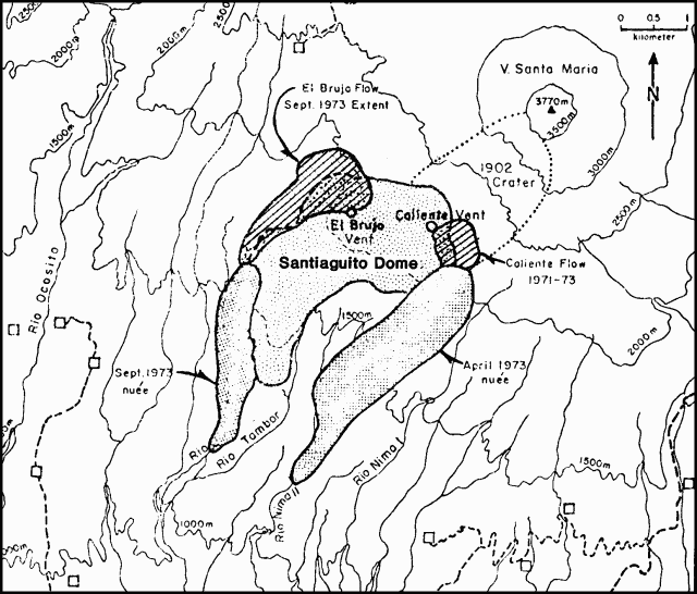 |
Figure 1. Map of Santiaguito and vicinity showing areas devastated by nuées ardentes in April and September 1973. Squares represent inhabited areas. From Rose, Pearson, and Bonis, 1976/7. |
"Lava extruded in 1976 from Caliente Vent and material washed by torrential rains from the walls of Santa María have helped to produce a flat floor in the 1902 crater, and easy access to the E flanks of Santiaguito for the first time in many years. Observations of Caliente Vent from the E show that it is now surrounded by a 50-m-high cone of ash, blocks, and bombs."
The Dartmouth-Michigan Tech. team could see burned vegetation extending at least 2 km down the valley of the Río Nimá II (on the S flank), indicating that ashflows have descended from the dome since the rainy season ended in October.
Reference. Rose, W. Jr., Pearson, T., and Bonis, S., 1976/77, Nuée ardente eruption from the foot of a dacite lava flow, Santiaguito Volcano, Guatemala: Bull Volc, v. 40, no. 1, p. 23-38.
Information Contacts: W. Rose, Jr., Michigan Tech. Univ.
Ash eruption; ashfall on Quetzaltenango
Press reports state that rumbling and seismic activity began at Santiaguito before dawn on 23 August, followed by a fallout of fine ash on Quetzaltenango (12 km NNE) and vicinity. At 1300, ash mixed with rain severely obscured visibility in the area and covered many sectors of Quetzaltenango with mud.
Information Contacts: P. Newton, Antigua.
Periodic pyroclastic eruptions; lava flow spawning nuées ardentes
The following report was received from Dartmouth College geologists who observed the volcano 11-24 November 1979.
"Activity was confined to the crater of Caliente dome, the oldest dome in the complex. Periodic pyroclastic eruptions were the predominant type of activity, occurring on average every 30 minutes (standard deviation = 24 minutes for n = 67). These eruptions lasted an average of 130 seconds (standard deviation = 150 seconds for n = 72). The eruption cloud in most instances rose about 1,500 m above the Caliente summit with some rising to 1,900 m (500 m above the summit of Santa María). At night, incandescent material was visible within the eruption columns. The pyroclastic activity has produced a horseshoe-shaped cone in the summit of Caliente vent which is open to the SSW. Ash generally blew NW and fell as far away as 3 km, where the leaves of plants were covered.
"COSPEC measurements of SO2 emission during the pyroclastic events show that 10-20 t/d of SO2 were being emitted from Santiaguito. The range of emission values is due to variations in the recorded eruption rates from day to day.
"Observations from the Finca Florida overlook S of the dome showed that there was a viscous flow moving out of the summit cone towards the SSW. The flow had proceeded perhaps 1/4 of the way down the side of the dome. Periodically there were rockfalls off the front of the flow that roll down the flanks of the dome into a barranca (dry valley). At night these rock falls were often spectacularly incandescent.
"Nuées ardentes that glowed at night were observed. They originated from Caliente crater. These appeared to erupt from the toe of the Caliente vent lava flow, perhaps generated when rock fell off the front of the flow exposing hot material beneath. The nuées traveled the same general path as the hot rock avalanches, SW into the barranca. Sporadic observations suggest that large nuées possibly occurred twice a day.
"Geologists ascending the dome made measurements on some of the fumaroles on Caliente. Most of the fumarolic vents seemed to be cooling off. Sapper fumarole was measured at around 82°C, significantly cooler than the temperatures of 170-300°C reported by Stoiber and Rose (1970) for the period of 1965-69. On the other hand, the von Türkheim fumarole seemed to have increased slightly in temperature to 120°C. There also appeared to be deposition of sulfur minerals at von Türkheim where previously only anhydrite was being deposited."
Information Contacts: R. Stoiber, L. Malinconico, R. Naslund, and S. Williams, Dartmouth College.
Ash explosions, lava extrusion, and hot avalanches continue
The following is a report from W.I. Rose, Jr., based on air and ground observations 22 January-10 February.
"Activity was similar to that of the past 5 years, characterized by steady weak gas emission from Caliente vent, punctuated by ash explosions at intervals of 1/2-6 hours. Ash from some of the explosions reached heights of more than 2.5 km above the crater. Particularly large blasts were observed on 22 January at 0945, 26 January at 1500, and 6 February at 1110. On 26 January, a dusting of ash fell on Quetzaltenango.
"Caliente vent was surrounded by a cone of debris that by 28 January had reached the height of the highest spines (2,500 m above sea level) on the dome. The cone was breached on the S side, and a 400-m-long blocky lava flow descended from the mouth of the vent down the talus slope to the S, where it broke up into hot, dusty avalanches. These avalanches occurred almost continuously and larger ones resembled small nuées ardentes. No activity (other than fumarolic) was observed anywhere else on the dome. The combination of lava flow activity and ash explosions at Caliente vent is similar to activity described by Von Türkheim in the 1930's. At that time, nuées ardentes became quite prominent."
Information Contacts: W. Rose, Jr., Michigan Tech. Univ.
Ash and gas eruptions eject blocks and tephra
Ash and gas eruptions from Caliente vent occurred irregularly over the 3-day period of observation, with intervals of 1/2-4 hours between eruptions. Most eruptions lasted 2-3 minutes and sent ash and gas columns to heights of several hundred meters to 1 km above the vent. Five mm of ash accumulated at the foot of the dome over one 12-hour period. Eruptions occasionally threw 10-cm blocks several hundred meters and ejected tephra to well above the summit of Santa María. Although not directly observed, the plug dome and blocky lava flow that were seen being extruded from Caliente vent in February were apparently still very active. Large avalanches of glassy material could be heard from Caliente vista many times per hour. Debris from these avalanches was visible in the barranca below Santiaguito.
Information Contacts: R. Stoiber, S. Williams, R. Naslund, M. Conrad, and L. Malinconico, Dartmouth College; S. Bonis, Instituto Geográfico Nacional (IGN); A. Aburto and D. Fajardo, Instituto de Investigaciones Sísmicas, Nicaragua.
Ash and gas emissions; avalanching
Three geologists from Michigan Tech. Univ. spent 12 February on Santiaguito Dome. At 1410 an explosion at Caliente Vent sent up a 400-m-high vertical column of fine ash. It was the only explosion in 8 hours of observation, but two increases in the vent's vapor plume indicated additional gas emissions during that time. The vent was more active late last year when other geologists visited it.
Large dust clouds in the early morning suggested that avalanching was continuing down the SE slope of the dome. Fine ash coating the leaves and the ground was notable in the area NW of the volcano.
Information Contacts: W. Rose, Jr., T. Bornhorst, and C. Chesner, Michigan Tech. Univ.
Explosive activity continues
On several occasions between 17 February and 2 March, R. W. Hodder and a group of students observed explosive activity at Santiaguito Dome. They saw morning eruptions from Caliente Vent on 17, 23, 24, 26, 27, and 28 February and 2 March, and late afternoon eruptions on 17 February and 2 March.
The group climbed Santiaguito on 23 and 24 February. During one eruption, accretionary lapilli fell, followed by raindrops coated with fine ash. About 1000 on 26 February, a large 30-minute eruption of gas with very little ash occurred from Caliente Vent. The eruption column rose to about 1,800 m, reaching a diameter of about 500 m (much larger than any other observed by Hodder's group) and forming a well-developed anvil-shaped top. At its maximum, the upper 25% of the column was ash-poor, nearly white vapor while the lower 75% darkened downward to a light brown (lighter colored than the 12 February eruption column described last month).
The group saw eruptions at 1000 and 1115 on 28 February during 5 hours of observations. The first consisted of a single 10-minute pulse that sent a vapor column to about 500 m above the vent. The second comprised four pulses in 30 minutes. Each pulse began with a white-topped column that developed a light tan base and an anvil-shaped top as it rose as much as 1,500 m above the vent. Between each pulse there was intense fuming.
Dartmouth College scientists climbed to the summit of Santa María on the morning of 24 March. They provided the following report.
"The plug dome previously observed in the crater of Caliente Vent was clearly visible and appeared to be covered with huge blocks of light gray lava. Four eruptions occurred within 3 hours with repose periods of 20 minutes, 1 hour, and 1 hour 40 minutes. Each was ash-rich and clearly audible from the summit (a distance of 2.8 km). All rose in the gas-thrust phase to approximately the elevation of the summit (a vertical distance of 1,272 m) and beyond convectively.
"Avalanches in the crater and down the SW flank occurred every 5-15 minutes suggesting nearly continuous activity of the dome. The several hundred meter-long lava flow, visible on the SW flank in February 1980 was not visible from the summit but avalanche clouds rising from that area suggested that it was still active there.
"One large fumarole in the NW part of the plug dome was continuously and very vigorously degassing, remaining essentially unchanged even during eruptions. All four eruptions began in the NE and E region of the crater and lasted 2-4 minutes."
Information Contacts: R. Hodder, Univ. of Western Ontario; T. Bornhorst, C. Chesner, W. Rose, Jr., Michigan Tech. Univ.; S. Williams, M. Mort, Dartmouth College.
Block lava flow; explosions continue
"Santiaguito was observed on 10 and 11 February during excellent weather conditions. A group of scientists climbed the volcano on 10 February in an attempt to sample gases at Caliente Vent (at the E end of the dome). All activity was from Caliente Vent. The tuff ring surrounding the vent was breached to the S and a block lava flow was actively descending a 25° slope, terminating after 300 m in an active scree flow. Avalanching occurred several times per hour.
"Ash eruptions occurred at 1- to 2-hour intervals from Caliente Vent. These reached altitudes of 3.5 km, 1 km above the vent. Fine light brown ash fallouts resulted and the top of the dome had a thick ash mantle, which made walking much easier than in previous years. Some of these eruptions lasted 15 minutes, most only 2-5 minutes. High-frequency noise similar to jet engines pulsated and changed frequency during the eruptions. All of the activity was similar to previous observations. The ash eruptions were identical to those seen consistently since 1975. The block lava flow represented a low rate of lava extrusion, which has been occurring for at least the past 2 years."
Information Contacts: W. Rose, Jr., Michigan Tech. Univ.; T. Casadevall, USGS; W. Zoller, Univ. of Maryland.
Eruption causes flooding and evacuations
The newspaper El Gráfico reported 26 August that activity from Santiaguito had forced the evacuation of hundreds of residents of towns on and near its flanks. The activity caused the overflow of the Nimá River, leaving hundreds of families in the Nimá valley homeless. No additional information was available.
Information Contacts: Diario El Gráfico, Guatemala City; P. Newton, Antigua.
Occasional explosions; rockfalls
On 29 and 30 January, Maurice Krafft flew over Santiaguito. Explosions about once every 2 hours from Caliente Vent ejected gray, relatively ash-poor plumes. On 29 January at 1114, an eruption column rose to about 4.5 km altitude, 2 km above the vent, and another column reached about 3 km altitude the next day at 0946. No rockfalls were noted at the fronts of viscous block lava flows that had been active in previous years, and pilots reported that the flow fronts had also been quiet a few weeks earlier. High above the dome, frequent rockfalls occurred from the NE part of Santa María's crater, breached during the major eruption of 1902.
Information Contacts: M. Krafft, Cernay, France.
Small ash ejections; mudflow damages town
"A group from Michigan Tech. and INSIVUMEH visited Santiaguito 15-16 November to observe its activity and recent mudflow damage. Activity was very similar to that of February 1982 with small vertical ash eruptions occurring at 30-minute intervals. Typical eruption cloud heights were 200-300 m above Caliente Vent, which has built an ash cone around it to an elevation equal to the highest spines of the dome (2,500 m). Occasionally in the last few months much larger explosions, to elevations of at least 1 km above the vent, have been observed by residents of the coastal slope. Extrusion of lava continues from the area near Caliente Vent, producing incandescent rockfalls into the Río Nimá II and other nearby rivers (figure 2).
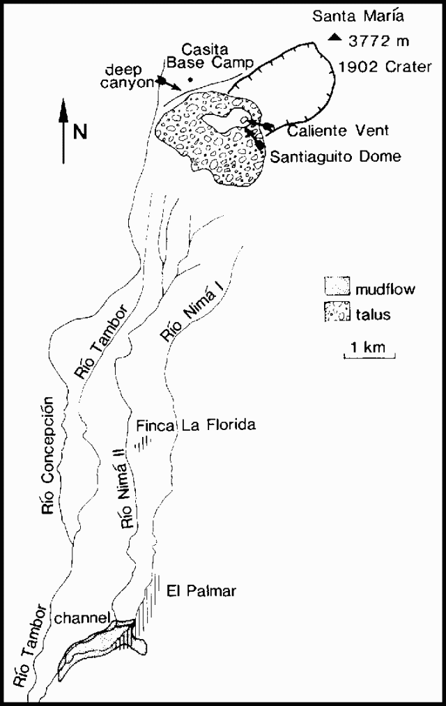 |
Figure 2. Sketch map of the vent area and part of the S flank of Santiaguito, showing drainage affected by mudflows. The area occupied by houses at El Palmar and Finca La Florida is indicated by vertical ruling. Other inhabited areas are not shaded. |
"The combined effects of continued lava extrusion and avalanching, the incessant ash emissions, and an unusually wet rainy season have increased the hazard of mudflows in the Río Nimá II, Río Tambor, and Río Concepción south of Santiaguito. Around and just below the dome at 1,700-2,000 m, deep canyons have been incised into the volcanic debris. On the N side of the dome, the 1902 crater has been breached and a deep canyon separates the dome from the Casita Base Camp. The formerly stabilized talus slopes of the dome have become active again because of the erosion from below. Beginning in late June and continuing into August, the Río Nimá II was especially active, aggrading several tens of meters at Finca La Florida (900 m altitude) and downstream at the town of El Palmar (680 m altitude). The situation at El Palmar was complicated by the confluence of Ríos Nimá I and II. The debris in the Nimá II eventually dammed the Nimá I, creating a natural reservoir which was becoming larger quickly. More and more mudflow and fluvial debris choked the previous mouth of the Nimá I. A channel was dredged through the debris but before it could be sufficiently deepened the Nimá I broke out of its reservoir and suddenly overflowed into the southern part of El Palmar. Evacuation of several hundred people prevented loss of life there, but several dozen houses were completely destroyed by mudflows created by the reservoir waters and the volcanic debris. As the rains lessened, the rivers seemed to be downcutting into the new laharic material and the danger of mudflows seemed less."
Further Reference. Rose, W.I., 1987, Volcanic activity at Santiaguito Volcano, 1976-1984: Geological Society of America Special Paper 2121, p. 17-27.
Information Contacts: W. Rose, Jr., S. Halsor, and T. Bornhorst, Michigan Tech. Univ.; E. Quevec Robles and C. Martínez, The Instituto Nacional de Sismología Vulcanología, Meteorología, e Hidrología (INSIVUMEH), Guatemala City.
Gas and ash emissions; seismicity
INSIVUMEH geologists observed explosive activity and seismicity at Santiaguito during visits in late January and early February. Seven gas and ash ejections occurred on 24 January between 1230 and 1730, and 9 were seen between 0945 and 1030 the next day. Eruption clouds rose 1-2 km above Caliente vent. Similar activity has been observed during the past few months. Vigorous fumaroles were present near the vent. At El Brujo vent, on the NW side of the dome, only fumarolic activity was observed. On 8-9 February, gas and ash ejections again occurred from Caliente vent but were weaker and less frequent than in late January.
A portable seismograph was installed N of the volcano (near the Hotel Magermann) on 25 January. Very shallow B-type earthquakes accompanied the eruptions. The number of events recorded each day ranged from none 27-28 January to 77 on 2 February. Continuous seismicity was recorded for more than 11 hours on 25 January and for periods of several hours each 1-4 February (figure 3).
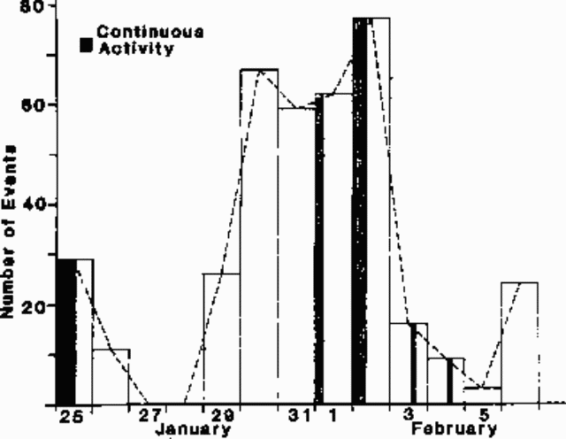 |
Figure 3. Number of recorded seismic events per day at Santiaguito, 25 January-6 February 1985. Periods of continuous seismicity are shaded (25 January, 0115-1230; 1 February, 0145-0540; 2 February, 0120-0930; 3 February, 1335-1615; and 4 February, 1300-1600). Courtesy of Edgar Quévec. |
Information Contacts: E. Quévec Robles, INSIVUMEH.
Lateral blast and pyroclastic flow on S flank
A lateral blast and pyroclastic flow occurred on 1 December at 1330, damaging 2.5 km2 of vegetation on the S flank. Ash clouds reached 3,600 m height and up to 5 cm of ash were deposited. Three new fumaroles appeared on the S flank.
Newspapers reported that debris from the eruption blocked two rivers and caused floods in several villages. Many families were evacuated. Explosions, increased seismic activity, and continuing lava flow from the crater were reported on the day of the eruption.
Information Contacts: E. Sánchez and Edgar Quévec, INSIVUMEH; ACAN News, Panama City, Panama.
Rain causes S-flank mudflows, floods
On 31 May, rain-induced mudflows caused flash floods on the Nimá II and Tambor rivers, affecting the S flank town of El Palmar. No casualties were reported.
Mudflows and floods have been a persistent problem for S-flank residents. In 1978, blocks and ash from Santiaguito dammed three rivers, forming a large lake. Failure of the debris dam caused damaging mudflows in July and another mudflow in September killed one person. An overflow of the Nimá River forced the evacuation of hundreds of people in August 1982. The 1983 rainy season saw more mudflows and evacuations in the same river valleys. Debris from an eruption on 1 December 1986 blocked two rivers and caused floods in several villages.
Information Contacts: E. Sánchez, Edgar Quévec, and Enrique Molina, INSIVUMEH.
Block lava flow into canyon; constant avalanching
INSIVUMEH technicians visiting the volcano 12-13 May observed block lava from the active (Caliente) vent flowing south, forming a well-defined channel. The flow front was at 1,300 m elevation, farther downslope than in March, in a steep canyon that contains a tributary of the Nimá II river in the rainy season. Continuous avalanches of large blocks occurred from the flow margins, producing light-colored dust and ash clouds.
When INSIVUMEH personnel next visited the S flank, on 19 June, lava continued to flow from the S side of the dome. Since mid-May, the flow front had advanced 250 m and its elevation was nearly 60 m lower. Incandescent material was visible in one crack at the flow front and heat was felt 70 m away. Constant avalanches produced clouds of hot light-colored ash and were accompanied by tremors and rumbling. Rains continued to transport new material into river valleys.
Information Contacts: E. Sánchez, INSIVUMEH.
Lava flow from dome; many avalanches; explosions
An incandescent block lava flow continued to emerge from Cono Caliente (the active crater on the E side of the dome), advancing down the S flank. By the end of July its front was between 1,200 and 1,300 m elevation in a canyon 80 m wide and 30 m deep, about 1.5 km from the Nimá II river. Numerous avalanches occurred from the flow front and along its channel. There were some reports of explosions from the flow front; fumaroles and a gaseous odor were noted there by geologists. Sporadic explosions from Cono Caliente ejected light-colored ash, and gas emission was continuous.
Information Contacts: E. Sánchez, INSIVUMEH.
Explosions, ash emissions continue
Activity from the lava dome continued in January, as explosions were accompanied by ash emission. The block lava flow that has been emerging from Cono Caliente was continuing to advance in November 1987.
Information Contacts: E. Sánchez, INSIVUMEH.
Lava descends S flank valley; lahars fill channels
The quoted material is a report from William Rose.
"Santiaguito was observed by scientists from INSIVUMEH, Michigan Tech and Arizona State Universities, and the Smithsonian Institution 10-16 February, the initial days of an intensive volcanic hazard study that will continue until April.
"Caliente vent was the focus of activity, as it has been for every observation since 1977. A dacite lava flow 3.5 km long was being extruded and was advancing SSW, filling the steep valley of a tributary of the Río Nimá II (figure 4). The flow is the result of continuous extrusion from Caliente vent since 1975. During the first 9 years, the extrusion fed a lava flow that extended only a few hundreds of meters from the vent, where it oversteepened, generating incandescent avalanches and small block and ash flows (Rose, 1987). Lava began to descend the southern slopes of Caliente vent in June 1986, but the flow was much more extensive in May and June 1987. Its movement is now generating incandescent rockfalls and small block and ash flows. These affect the upper, steeper parts of the lava flow and an oversteepened mound downslope (over a constricted part of the former river drainage into which the flow is channeled). The present flow is the longest yet observed in Santiaguito's 66 years of continuous activity and represents an increase in the extrusion rate since 1985. This is the seventh period of rapid extrusion at Santiaguito. Previous episodes have recurred about every 10-12 years and lasted about 3-5 years.
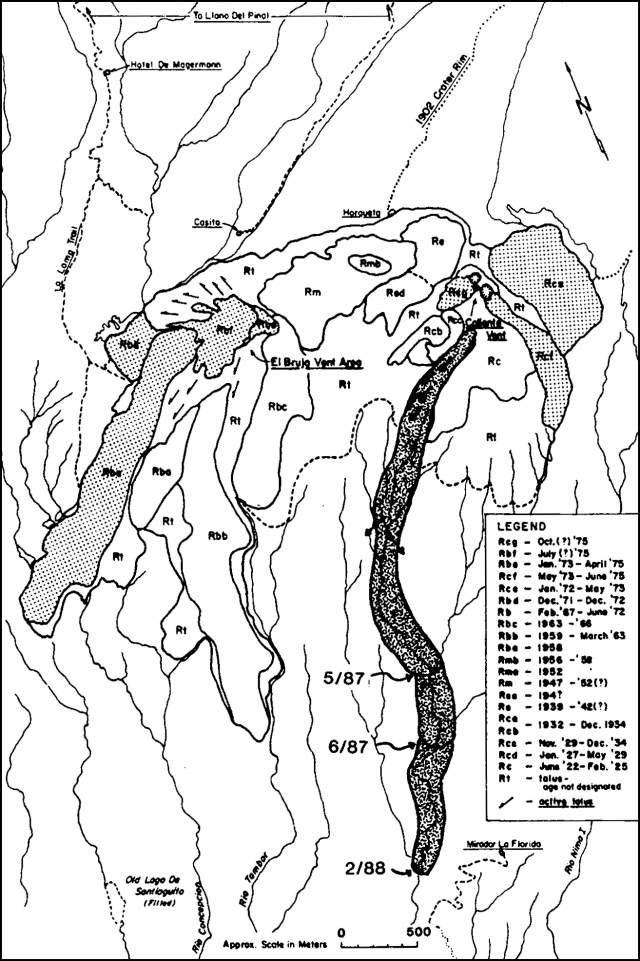 |
Figure 4. Map of Santiaguito Dome, showing the ages of its lobes. The 1986-88 flow is emphasized by a shaded pattern; other recent lobes are stippled. Successive positions of the 1986-88 flow front are dated. Courtesy of William Rose. |
"Caliente vent is also the source of vertical, possibly phreatomagmatic eruptions of fine-grained dacite ash, very similar to those described 1975-84. They occur as often as 1 or 2 times an hour and consist of very brief (1-2-minute) emissions, some of which reached altitudes of 4,000 m (about 1,500 m above the vent). Light ashfalls (<0.1 mm thick) affect areas as much as 6 km from Santiaguito." The geologists who visited Tacaná on 27-28 January also made observations from about 2 km W of Santiaguito on 30 January. Steam and ash were ejected at 0930 and 1000. A local observer, Alejandro Chávez, reported some roaring, whistling noises, and very minor seismicity.
"An important result of the current activity has been the accelerating sedimentary load (chiefly laharic) into river systems downslope (figure 5). Most now enters the Río Nimá II, which has aggraded by at least several tens of meters for its entire length. The formerly incised channels are now filled and in many places the riverbed is far above the elevation of former confluences with tributaries, resulting in their damming and redirection. The situation has caused increasingly difficult problems for residents of villages and plantations in the area. The most serious affect the town of El Palmar, which has been frequently flooded by the Río Nimá I.
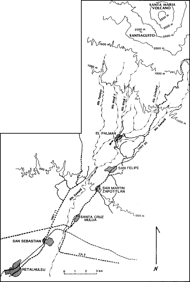 |
Figure 5. Sketch map of rivers and towns S of Santiaguito. Locations of drainages are approximate. The location of the former confluence of the Río Nima I with the Río Nima II near El Palmar is marked with an arrow. Courtesy of William Rose. |
"Blocked from its former confluence with the Río Nimá II by mudflow accumulations, it now flows through El Palmar into the Río Samalá (figure 5). At El Palmar, the Río Nimá II flows less than 100 m from the Río Nimá I, with no remaining topographic barriers other than mudflow levees. Erratic mudflow deposition in the coming rainy season could divert the entire Río Nimá II, including its mudflow load, via the Río Nimá I into the Río Samalá over a waterfall more than 100 m high, at a point 3 km N of the present confluence. Near San Felipe (14 km SSW of Santiaguito), the Río Nimá II aggraded by more than 20 m during the last rainy season (May-November 1987). Similar aggradations occurred as far south as San Sebastián (22 km SSW of Santiaguito) in the Río Samalá, which receives the Río Nimá II just W of San Felipe. Because of strongly parallel drainage systems, filling of the Río Nimá II and the Río Samalá must eventually result in overflow into nearby rivers, which are at significantly lower levels. The consequences of such stream diversions are complex and hard to rigorously forecast, but such problems occupy much of the current hazard study because the area S of El Palmar is densely populated."
Reference. Rose, W.I., 1987, Volcanic activity at Santiaguito Volcano, 1976-1984 in Fink, J., ed., The Emplacement of Silicic Domes and Lava Flows: GSA Special Paper 212, p. 17-27.
Information Contacts: W.I. Rose, Reinaldo Mercado, and James Vallance, Michigan Tech UniversityOtoniel Matías, Jorge Girón, and Francisco Alvarez, INSIVUMEH; J. Fink and Steve Anderson, Arizona State University; Lee Siebert, SI; Gerardo Sánchez Rubio, Estación Regional del Centro, Instituto de Geología, UNAM, Guanajuato, México.
Continued lava extrusion & explosions; rainy season lahar damage moderate
INSIVUMEH geologist Otoniel Matías reports that the dacite lava flow that extended 3.5 km SSW of the active Caliente vent by February 1988 (13:02) had stagnated there since February, although extrusion was continuing at a reduced rate. Geologists noted continuing small avalanches from the upper portion of the flow on 23 November. The middle portion of the block lava flow (about 1.5 km NNW of Mirador La Florida) was steaming, but remained stagnant. However a new lobe had advanced along the W margin of the flow to about 1.3 km from Caliente vent (figure 6).
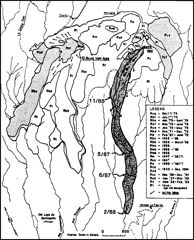 |
Figure 6. Map of Santiaguito Dome, showing the ages of its domes. The 1986-88 flow is emphasized by a shaded pattern; other recent lobes are stippled. Successive positions of the 1986-88 flow are dated, and the approximate November 1988 location of the new lobe is shown. Modified from Rose (1987). |
Small to moderate vertical explosions from the Caliente vent have continued. The number of explosions, as determined from field observations and seismic records from stations 5 km NNW and 2.6 km S of Santiaguito, has been tabulated by Matías since June (figure 7). Daily explosion totals during June ranged from 5 to 22. Activity decreased steadily through most of July, but increased again August-October, reaching a peak of 28 explosions on 19 October. Larger explosions produced steam and ash columns that rose 1-2 km above Caliente vent; secondary explosions to 400-1,000 m height occurred at roughly similar rates. The number of small block-and-ash avalanches from the active lava flow ranged from about 100 to 250/day in June and dropped to around 50-150/day in July, paralleling the drop in explosion frequency. From August through October the daily number of avalanches ranged from about 100 to over 300.
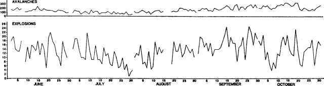 |
Figure 7. Number of daily explosions (bottom) and an extrapolation of the number of daily avalanche events (top) recorded by seismic stations near Santiaguito, June-October 1988. Field observations of eruptive phenomena were correlated with records from a portable seismograph to identify their seismic signatures. Courtesy of Otoniel Matías. |
The sediment load from Santiaguito has continued to impact downslope river drainages, but the effects of the 1988 rainy season were relatively mild compared to past years. The El Palmar area was observed in November to be essentially unchanged from February, as the Río Nimá II remained contained within perched levees above the town. However, downstream lahars destroyed the supports of an important foot suspension bridge across the Río Samalá below San Felipe, about 14 km SSW of Santiaguito (figure 8); reconstruction of this bridge was continuing in November. The Carretera Internacional del Pacífico (CA2) below Santa Cruz Muluá was closed briefly in late August and around 4-5 September as floods deposited sand and gravel over a 150-m section of the highway. The Río Samalá was again diverted by rainy season lahars into the Río Ixpatz drainage, innundating portions of the Finca San José La Granja (about 5 km S of the sharp bend in route CA2). This diversion of river courses into parallel drainages has occured each year since 1983. The annual construction of barriers to return the Samalá to its normal course had not been completed in November. The Samalá also partially diverted the Río Muluá to the east.
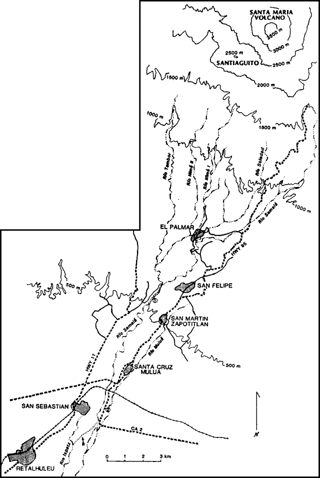 |
Figure 8. Sketch map of rivers and towns S of Santiaguito, modified from a February 1988 sketch by William Rose. Locations of drainages are approximate. Arrows mark the location of the diversion of the Río Samalá into the Río Ixpatz and the former confluence of Ríos Nimá I and II near El Palmar. Points 1 and 2 indicate the damaged bridge below San Felipe and the flooded segment of route CA2. |
Information Contacts: Otoniel Matías and Enrique Molina, INSIVUMEH; Jim Vallance, Michigan Tech; Lee Siebert, SI.
Increased explosive activity; possible new lava flow
Increased explosive activity began in late February. Seismic records showed about six explosions/day through most of February, but a distinct increase was observed beginning 24 February [but see 14:06], reaching 20/day by 28 February. On 3 March, geologists climbing Fuego, roughly 75 km ESE, saw several vigorous ash emissions/hour from Santiaguito. Ash fell on Quezaltenango, 12 km NE, and Zuñil, 10 km ENE. Residents of the area suspect that a new lava flow may have formed [see 14:06]. Glow was observed from the previously active Caliente and El Brujo vent areas during the night of 12-13 March.
Information Contacts: INSIVUMEH; Michael Doukas and John Ewert, USGS.
Lava production; explosions; hot avalanches
Santiaguito's most recent (7th) period of rapid block lava extrusion began in June 1986 and had declined about February 1988. A small lobe that descended slowly toward the W margin of the lava field was 1.3 km from the dome's Caliente vent in November 1988. Very slow extrusion continued until the onset of a new period of vigorous lava production around 14 February. Observations 23-24 March revealed that the new lava flow, about 70 m wide and 20 m thick, was overriding the June 1986-February 1988 lava (figure 9) and its oversteepened front had reached about 1,470 m altitude. Moderate pyroclastic avalanches generated by collapse of the flow at the altitude of maximum slope (2,000-1,800 m) and at its oversteepened front partially filled canyons in the headwaters of the Río Nimá II and the tributary E of the lava flow. Brief observations 3 May about 1 km from the flow (at El Mirador) showed no substantial changes.
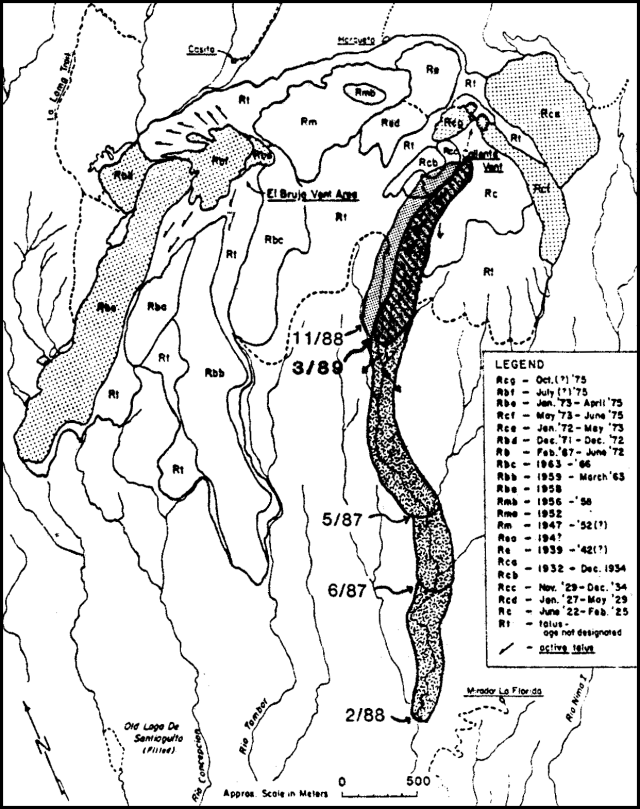 |
Figure 9. Map of Santiaguito Dome, showing the ages of its lobes. Succesive fronts of 1986-89 lava flows are shown. Modified from Rose and others (1987). Courtesy of Otoniel Matías. |
During September and October 1988, seismic instruments 2.6 km S and 5 km NNW of Santiaguito recorded 8-28 explosions and 130-330 avalanches/day. After the beginning of November, the number of explosions declined to 4-16 daily and the number of avalanches to 60-120 (figure 10), remaining at similar low to moderate levels through late February. More violent explosions began on 25 February and continued through 13 March, stronger than any since the start of vigorous block lava extrusion in June 1986. Some dense ash columns rose at least 3 km above the crater and were visible from the summit of Fuego, 75 km away. Ash columns during this period easily exceeded the height of Santa María's summit (3,772 m), more than 1,200 m above the vent, forming mushroom-shaped clouds 1 km in diameter. Ash reached parts of Quetzaltenango, 12 km NE, within 15 minutes. During this period, 8-26 explosions were recorded daily. The strongest produced acoustic waves that moved suspended objects 7 km to the S (at Finca El Faro). Sounds similar to a jet turbine continued for up to 4 minutes, alternating with the phreatomagmatic explosions. Winds 24-25 February were dominantly from the N-NE at 20-30 km/hour; fine ashfall was reported to 28 km S-SW (in the El Palmar, San Felipe, and Retalhuleu regions). From 26 February through 13 March, winds were generally from the S-SW, calm in the morning and reaching 18-30 km/hour in the afternoon. Fine ash was carried 7-25 km NW and NE; losses from vegetation damage were reported in Llanos del Pinal, Almolonga, and Quetzaltenango (7, 12, and 14 km N-NE).
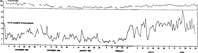 |
Figure 10. Number of daily explosions (bottom) and an extrapolation of the number of daily avalanche events (top) recorded by seismic stations 2.6 km S and 5 km NNW of Santiaguito, November 1988-April 1989. Courtesy of Otoniel Matías. |
A brief decline was evident 14-16 March, with only 6-10 small explosions daily generating clouds <=1 km high. Activity increased again 17 March, dominated by degassing that produced dense whitish clouds with little ash and moderate to strong jet turbine sounds. Between 14 and 24 explosions/day were recorded through 31 March. The number of explosions grew gradually in early April, reaching 34 on the 18th (the most recorded in a single day since June 1988) then fell to 14-26/day after the 21st. Avalanches from the dome, the central area of the lava flow (2,000-1,700 m elevation), and its oversteepened front ranged from 150 to 300/day.
Weak to moderate fumarolic emissions persisted from the N and S margins of the Caliente vent area. The E fumarole was more active and acted as a secondary crater during some explosions, feeding columns that were similar to or smaller than those from the main vent. The E fumarole may have been the source of the jet turbine sounds as it underwent high-pressure degassing. After some explosions, its emissions increased, often persisting for several hours as sustained columns rose tens of meters to 1 km. Very weak fumarolic emissions occurred throughout the summit area of the dome complex, frequently linked with increased activity from Caliente vent.
At press time, we learned that Santiaguito erupted an ash column to 4 km above the dome on 19 July at 0915 [see also 14:07]. A pyroclastic flow traveled 5 km down the Río Nimá II, reaching 2 km from Finca La Florida. Ash was 1 cm thick at Finca Monte Bello (6 km WSW) and fell as far as the Mexican border. Thirty two Central American volcanologists, attending a course in El Palmar (12 km SSW of the volcano), witnessed the eruption during good viewing conditions, took photographs, and made a videotape. The eruption was followed by two smaller explosions within 1/2 hour, and another at 1600. Prelimimary observations by volcanologists suggest that the eruption may have been associated with partial collapse around the vent. There were no reports of death or damage.
Information Contacts: Otoniel Matías and Jorge Girón, INSIVUMEH; W. Rose, Michigan Technological Univ.
Details of 19 July explosion
The following supplements the preliminary report in BGVN 14:06.
"On 19 July, 32 Central American volcanologists were completing a field hazard mapping project, part of a training course sponsored by the Centro de Coordinación para la Prevención de Desastres Naturales en America Central (funded by the government of Sweden). The course prepared volcanic hazard reports and maps for Cerro Quemado, Guatemala, but on 19 July participants were touring the area near El Palmar (12 km SSW of Santiaguito) to view deposits and damage caused by river aggradation associated with continual activity at Santiaguito since 1973.
"At 0915, during excellent viewing conditions, the group observed a spectacular vertical explosive eruption and pyroclastic flow from Santiaguito (figure 11). The vertical explosion and pyroclastic flow occurred simultaneously, apparently associated with a minor (?) collapse of part of the dome near Caliente Vent. The ash cloud rose about 4 km above the vent, and was clearly observed from Llano del Piñal, 6 km NNE. Ashfall occurred in the areas W and SW of the volcano. The maximum measured thickness was 1 cm at Finca Monte Bello (6 km WSW), but ash fell at least as far away as the Mexican border (65 km distant). The pyroclastic flow followed the same path as recent lava flows from Caliente Vent, descending into the valley of the Río Nimá II and forming a block-and-ash flow and ash cloud surge that mantled some of the 1987-89 lava flow. The main part of the pyroclastic flow traveled 5 km, about 1 km farther downstream than the April 1973 pyroclastic flow (figure 20; Rose, 1973; and Rose et al., 1976/7), and thus probably represents the largest since the 1929-34 activity (Sapper and Termer, 1930; Termer, 1934; and Reck and von Tuerckheim, 1935). Some of the ash cloud surge from the pyroclastic flow probably traveled a shorter distance eastward, based on distant observations of burned vegetation. The composition of hot blocks in the new block and ash flow deposit, collected on the afternoon of 19 July is dacite (64% SiO2), identical to other recent samples and nearly all of the dome rocks extruded since 1922.
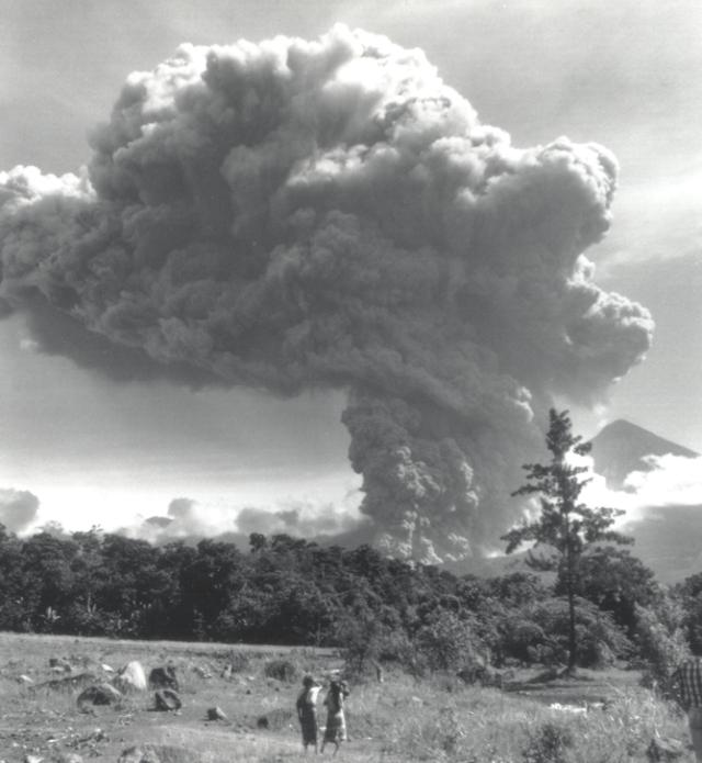 |
Figure 11. Photograph of Santiaguito's eruption column on 19 July 1989 at about 0920, looking N from the valley of the Río Nimá II just W of El Palmar, Guatemala. The tephra cloud and pyroclastic flow are shown about 5 minutes after onset of the eruption. Santa María volcano, in the right background, has a summit elevation of about 3,700 m. Courtesy of Mike Conway. |
"Visibility was lost within 2 hours after the eruption. A much smaller vertical explosion occurred about 20 minutes after the first, followed by two smaller phreatomagmatic eruptions before 1000. A small vertical eruption was also observed at about 1615." [see also Atmospheric Effects, BGVN 14:8-11].
References. Reck, H., and von Tuerckheim, O.G., 1935, Die Zustand der Vulkane Fuego, Atitlán, und Santa María in Guatemala Ende 1934: Zeitschrift für Vulkanologie, v. 16, p. 259-263.
Rose, W.I., 1973, Nuée ardente from Santiaguito volcano, April 1973: Bull Volc, v. 37, p. 365-371.
Rose, W.I., Pearson, T., and Bonis, S., 1976/77, Nuée ardente eruption from the foot of a dacite lava flow, Santiaguito volcano, Guatemala: Bull Volc, v. 40, p. 23-38.
Rose, W.I., 1987, Volcanic activity at Santiaguito volcano, 1976-1984 in Fink, J., ed., The emplacement of silicic domes and lava flows: GSA Special Paper 212, p. 17-27.
Sapper, K., and Termer, F., 1930, The eruption of Santa María volcano in Guatemala of November 24, 1929: Zeitschrift für Vulkanologie, v. 13, p. 73-101.
Termer, F., 1934, Die Tätigkeit des Vulkans Santa María in Guatemala in den Jahren 1931-1933: Zeitschrift für Vulkanologie, v. 14, p. 43-50.
Information Contacts: Otoniel Matías and Jorge Girón, INSIVUMEH; W.I. Rose, F. Michael Conway, and J.W. Vallance, Michigan Tech.
Occasional low-density ash ejections; small lava flow spawns rock avalanches
Geologists noted several low-density ash ejections from Caliente Vent during 1 1/2 hours of observations beginning at 0945 on 3 January. The largest, at 1010, produced a gas/ash plume 1,000 m high. Subsequent episodes were smaller, ejecting plumes to a few hundred meters above the vent. A small lava flow that was emerging from Caliente Vent moved slowly down the dome's upper SE flank. The flow was a few tens of meters long, with associated rock avalanche deposits extending several hundred meters from its front. Recent avalanche deposits were also visible S and SW of the vent.
Caliente Vent, on the E side of Santiaguito dome, has been the site of continuous lava extrusion since 1975. A strong explosion from the Caliente Vent area on 19 July 1989 may have been the source of small lower stratospheric aerosol layers detected at several sites in August and September (see Atmospheric Effects, 14:8-9).
Information Contacts: S. Halsor, Wilkes Univ; C. Chesner, Eastern Illinois Univ.
Viscous lava extrusion continues; rapid erosion of N flank
Santiaguito was visited by volcanologists from INSIVUMEH, Michigan Tech, and Arizona State 20-26 February. The following is from their report.
"Eruptive activity was still focused on Caliente vent, capped by a cone-shaped exogenous domal mass of lava that feeds a viscous flow directed toward the SSW. The flow extended about 500 m, dropping about 250 m in elevation below the top of the vent (about 2,500 m above sea level) and terminating on a talus slope at the angle of repose. Rockfalls were frequent, resulting in ash clouds. The frequency of vertical ash eruptions from Caliente vent was only a few/day. The rate of SO2 emission was measured on 22 February at 48 ± 15 t/d, with a range of 21-76 t/d (24 determinations). This emission rate was slightly less than the average of about 100 t/d (range 40-1,600 t/d) determined in July 1976, when there were many more vertical ash eruptions that had higher values, but was identical to the emission rates measured then between eruptions (Stoiber and others, 1983; especially Table 29.4).
"Figure 12 shows the pattern of Santiaguito's activity from June 1988 until 10 January 1990, five weeks before the dates of the most recent field surveys, as revealed from interpretation of telemetered seismic data by INSIVUMEH. The data demonstrate a good correlation between the frequency of avalanche events and vertical explosions. They also demonstrate that the February field observation dates represented a time of very few vertical explosions compared to the past year's record.
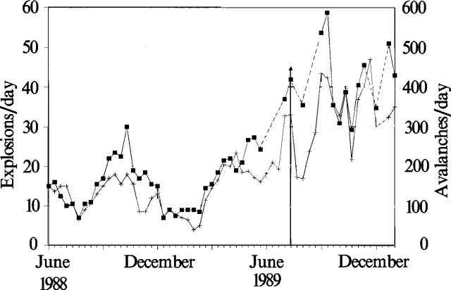 |
Figure 12. Mean daily number of explosions (crosses) and avalanches (squares) during 2-week periods at Santiaguito, as interpreted from telemetered data by INSIVUMEH, June 1988-January 1990. The 19 June 1989 eruption is marked by an arrow. |
"Significant changes have occurred on the N side of Santiaguito since July 1989 (figure 13). The El Monje dome, mostly extruded between 1947 and 1952, had developed a talus slope on its N side that was stabilized and had developed a strong moss coating that prevented rockfalls. This slope allowed access to the summit of Santiaguito throughout a long period (1964-88) and also to the 1902 crater of Santa María. Deep barrancas (canyons) have formed on the N side of the El Monje dome, cutting steep barriers into the talus slopes. These have coalesced at the edge of the talus slope, forming a large barranca between Santiaguito and Santa María that feeds an enormous amount of material into the (Isla) area farther W, and caused another deep barranca to form at the end of the Loma trail. The barrancas on the El Monje dome have deepened and migrated headward until they intersect the top of the dome. They could reflect fracturing of the El Monje dome, perhaps the weakest of three dome units that buttress the N side of the Caliente Vent. If viewed in this way the new barrancas could forecast the site of new dome extrusion from a lateral vent. The increased sediment load from this barranca system is likely to affect the Río Concepción and the Río Tambor to the south when the next rainy season arrives in April or May.
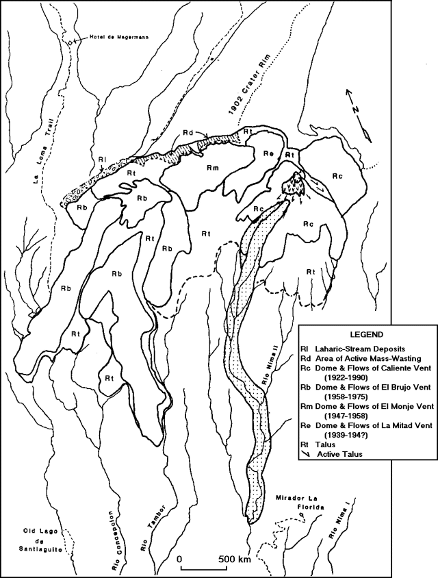 |
Figure 13. Simplified geologic map of Santiaguito Dome, 1922-February 1990. Streams near Santiaguito are approximately located. Unit dates, such as Rc (1922-90), represent periods of discontinuous activity at each vent. Patterned areas represent very recent activity: Rl - area of active laharic and stream deposition, and very high aggradation rates; Rd - area of recently initiated extensive mass wasting indicating inflation of the El Monje vent area and potential reactivation of the vent; Rc (v pattern) - active block lava flows on Caliente's summit, with very common (hourly) collapse of the broad toe resulting in hot rock avalanches; Rc (dotted pattern) - extent of the 1986-88 block lava flow from Caliente. |
"Fieldwork was also directed at examination of the areas affected by the 19 July 1989 eruption (figure 14). The outline of a distinct blast zone, marked by tree blowdown, was mapped. A collapse scarp facing the blast zone was observed. This shows conclusively that partial domal collapse accompanied the 19 July 1989 eruption (14:07)."
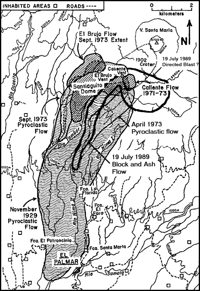 |
Figure 14. Map of Santiaguito and vicinity, showing the zones affected by the 1929, 1973, and 1989 pyroclastic flows. The 1989 and April 1973 deposits have similar areas but different sources. Modified from Rose, 1987. |
Reference. Stoiber, R.E., Malinconico, L.L. Jr., and Williams, S.N., 1983, Use of the correlation spectrometer at volcanoes, in Tazieff, H. and Sabroux, J.C., eds., Forecasting Volcanic Events; Elsevier, Amsterdam, p. 425-444.
Information Contacts: O. Matías and R. Morales, INSIVUMEH; W.I. Rose, J. Diehl, R. Andres, F.M. Conway, and G. Keating, Michigan Technological Univ; J. Fink and S. Anderson, Arizona State Univ.
Explosions feed large columns and pyroclastic flow
A series of strong explosions that began at about 1030 on 13 July sent eruption clouds to 7.5 km. Vigorous explosive activity continued until the next morning, depositing as much as 4 cm of ash, mostly S-SW of the vent. Geologists calculated a preliminary ash volume of 2.6 x 10⁵ m3. Damage from ashfall was minimal. A pyroclastic flow extended 6.5 km down the Nimá II valley, generating a large vapor cloud where it encountered river water. An overflight on 17 July revealed that the pyroclastic flow deposit had not dammed the river, a possibility that had concerned hazard officials. Smaller explosions typical of Santiaguito's long-term eruption continued after the end of the vigorous activity. Eight explosions were recorded on 14 July, the largest producing a cloud that reached about 3,000 m above sea level (roughly 500 m above the dome's summit); the other 7 were of relatively low energy. Four low-energy explosions were recorded on the 17th.
Information Contacts: E. Sánchez and Otoniel Matías, INSIVUMEH.
Explosions and pyroclastic flows; four killed in July blast; lava flow; lahars to 50 km
"Interpretation of telemetered seismic data by volcanologists at INSIVUMEH indicates a general increase in volcanic activity (pyroclastic eruptions, rock avalanches, and lava flows) at Caliente vent from June 1988 through August 1990 (figure 15). Five periods of increased lava flow activity have been documented, the most recent beginning in July 1990 (BGVN 15:06) and continuing as of early December. The number of explosions ranges from about 5 to 90 daily, while rock avalanches are more abundant, with 100 to as many as 600/day. Explosions, rock avalanches, and lava flow flux at the dome were greatest from June through September 1988, 1989, and 1990, corresponding to the rainy season. Small decreases in explosions and avalanches were noted during mid-October through March 1988-89, 1989-90, and from October through November 1990, and are roughly correlative with the dry season in Guatemala, suggesting a link between eruptive and climatic patterns at Santiaguito.
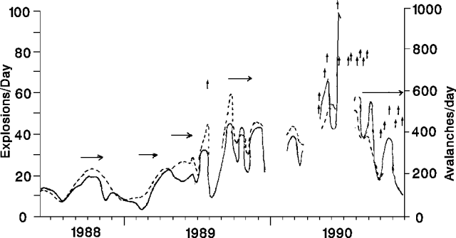 |
Figure 15. Appoximate number of daily explosions (solid line) and rock avalanches (dashed line) recorded by seismic stations near Santiaguito, June 1988-23 November 1990. Five periods of relatively high lava flow flux are marked by horizontal arrows. Vertical arrows mark dates of major pyroclastic eruptions. [Courtesy of Otoniel Matías.] |
"Beginning in April 1990, more than 20 powerful pyroclastic eruptions, similar in magnitude to the 19 July 1989 eruption, have occurred at Caliente vent (table 1). Direct observation of pyroclastic eruptions is often impossible because of weather conditions, but reports from four events indicate that they are characterized by large eruption columns rising 4-5.5 km above the vent, durations on the order of 7-15 minutes, and are heard as far away as Retalhuleu [25 km SSW]. Simultaneous collapse of a small plug dome atop Caliente generates pyroclastic flows and lateral blasts. Block and ash flows accompanied by ash cloud surges typically sweep 4-7 km down the Río Nimá II (figure 16); phreatic blasts in nearby drainages are common during violent mixing of hot pyroclastic flows with stream water. Repeated lateral blasts have devastated an area of 4 km2E of Caliente, stripped away or blown down all vegetation, and buried it in ash and lapilli-sized debris. On 19 July 1990, exactly 1 year after the onset of major pyroclastic eruptions at the dome, 4 hikers climbing along the E rim of Santa María's 1902 explosion crater, roughly 1 km E of the dome, were killed by a lateral blast. Tephra fallout (to 4 cm thick) blanketed the dome and surrounding area, and measurable airfall deposits (<1 cm thick) occurred as far away as San Martín, 20 km SW of the dome. Numerous smaller explosions accompanied major explosions at Caliente, and continuous explosive activity of up to 3 hours has been reported.
Table 1. Dates and intervals between major pyroclastic eruptions at Santiaguito Dome, July 1989-November 1990. Courtesy of Michael Conway.
| Date | Days since last pyroclastic eruption |
| 18 Jul 1989 | -- |
| 20 Apr 1990 | -- |
| 22 Apr 1990 | 1 |
| 05 May 1990 | 12 |
| 08 May 1990 | 2 |
| 09 May 1990 | 0 |
| 03 Jun 1990 | 24 |
| 19 Jun 1990 | 5 |
| 13 Jul 1990 | 23 |
| 19 Jul 1990 | 5 |
| 29 Jul 1990 | 9 |
| 05 Aug 1990 | 6 |
| 18 Aug 1990 | 12 |
| 22 Aug 1990 | 3 |
| 26 Aug 1990 | 3 |
| 22 Sep 1990 | 26 |
| 04 Oct 1990 | 11 |
| 26 Oct 1990 | 21 |
| 14 Nov 1990 | 18 |
| 20 Nov 1990 | 5 |
| 23 Nov 1990 | 2 |
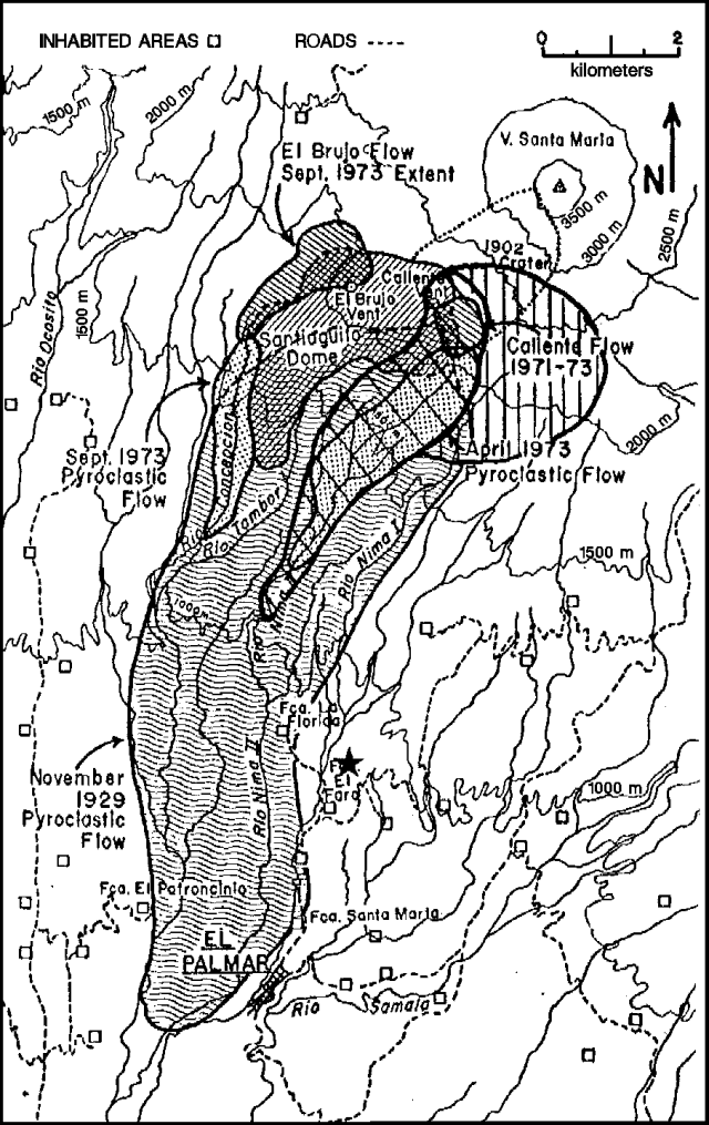 |
Figure 16. Map of Santiaguito and environs showing zones affected by the 1929, 1973, and 1989-90 pyroclastic flows. The zones affected in 1989-90 are marked by vertical lines (devastation by lateral blasts), and diagonal lines (area affected by pyroclastic flows and ash cloud surges). The Santiaguito Observatory is marked by a star. Courtesy of Michael Conway. |
"Periods between major explosions have been characterized by passive fuming of Caliente and by minor phreatomagmatic and possibly phreatic vertical explosions. On the morning of 28 November, from the 'Hotel de Magermann', NW of the dome, we observed a series of 15-20 small explosions; each was accompanied by a gray to white steam and ash column, rising 1.5-3 km above Caliente. Individual explosions were accompanied by a jet-like sound and lasted anywhere from a few seconds to 2-3 minutes. Passive fuming preceded and followed each blast.
"Since July, a viscous block lava flow, fed by a plug dome on Caliente, has advanced down the E side of the dome, and recently entered the headwater extension of the Río Nimá II system (figure 17). The flow is roughly 2 km long, 30-50 m wide, and 15-20 m high; a rough estimate of the average extrusion rate is 7,500 m3/day. Collapse of the lava flow front occurs frequently, and small-volume block-and-ash avalanches are common events. Merapi-type block and ash flows are less common and travel between 2 and 3 km down the Río Nimá II.
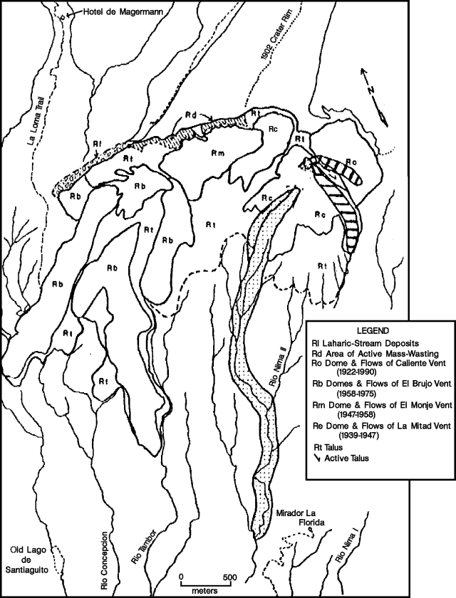 |
Figure 17. Simplified geologic map of Santiaguito Dome, 1922-November 1990. Streams near Santiaguito are approximately located. Unit dates, such as Rc (1922-90), represent periods of discontinuous activity at each vent. Patterned areas represent very recent activity: Rl - area of active laharic and stream deposition, and very high aggradation rates; Rd - area of recently initiated extensive mass wasting possibly indicating inflation of the El Monje vent and potential reactivation; Rc (v pattern) - active block lava flow on Caliente's summit, with very common (hourly) collapse of the broad toe resulting in hot rock avalanches; Rc (dotted pattern) - extent of the 1986-88 block lava flow from Caliente. Lava flows erupted since July 1990 are shown by diagonal and horizontal line patterns; the S-most unit, extending into the Río Nimá II drainage, was active as of 28 November. Courtesy of Michael Conway. |
"Lahars originating at Santiaguito, common during the past rainy season, extended S down the Río Nimá II to its confluence with the Río Samala, and continued for up to 50 km from the dome (figure 18). Diversion of lahars from the Río Samala into the Río Ixpatz occurred as it has in every year since 1983. Hot lahars (temperatures to 45°C were measured 25 km S of the dome) were observed and occurred hours to days after a major pyroclastic eruption. A particularly large lahar on 16 September destroyed the pedestrian bridge at El Palmar, forcing people of the surrounding area to ford the river on foot - a particularly hazardous endeavor during the rainy season. Rapid aggradation from lahars and hyperconcentrated floods continues in the Río Nimá and Río Samala systems.
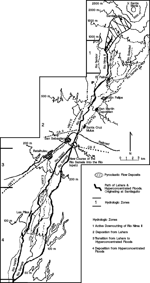 |
Figure 18. Sketch map of rivers and towns S of Santiaguito. Locations of drainages are approximate. Areas affected by pyroclastic flows, lahars, and hyperconcentrated floods are marked. Field studies during the 1990 rainy season indicate four zones with distinct hydraulic characteristics. [Courtesy of O. Matías.] |
"In order to monitor activity better at Santiaguito, INSIVUMEH and Centro de Prevención de Desastres Naturales en América Central (CEPREDENAC) have constructed a permanent observatory at Finca El Faro, 7 km S of the dome (figure 16). The observatory opened in the second week of November and will be manned around-the-clock, by trained observers. Equipment at the observatory includes: a paired seismometer-seismograph, seismographs for two outlying seismometers; deformation and survey equipment; and hand-held radios and radio-telephone equipment. A key function of the observatory is to act as a training post for geoscientists, and at present 25 geoscientists from throughout Central America are receiving training in seismology, deformation, and volcanic hazards at Santiaguito." [The following originally appeared in BGVN 16:02] The building site was donated by the owners of Finca El Faro and construction costs were paid by the government of Sweden through CEPREDENAC. The facility has laboratory space and a small dormitory, and is intended as a base of operations for volcanologists to work with local scientists at Santiaguito (through INSIVUMEH and other agencies).
Information Contacts: Otoniel Matías, INSIVUMEH; Michael Conway, Michigan Tech.
Frequent explosions eject ash
Four explosions were observed during 3 hours of observations on 10 January. The first, at 1015, produced a column about 3 km high and deposited ash, consisting of accreted fine (<1 mm) crystal and lithic fragments, at least 3 km NW of the vent. The explosion was preceded by a notable increase in the energy of degassing from Caliente vent, and a plume color change to brown, apparently reflecting greater ash content. The two subsequent explosions were not as energetic, but the fourth produced a column that appeared to be higher than the first. Additional tall eruption columns, >1,200 m high, were frequently observed on subsequent days.
Information Contacts: S. Williams, M. Calvache, S. Schaefer, T. Ross, and other field trip participants, Louisiana State Univ, USA; Otoniel Matías, INSIVUMEH.
Explosive activity declines; new volcano observatory
Seismometers near the volcano detected rates of rockfalls and explosions that were markedly lower in January and February (BGVN15:11 for a description of the Observatory, including material originally in BGVN 16:02]. More than 20 pyroclastic flows and lateral blasts were observed between April and early December 1990, but none have been reported since then. SO2 emission measured by COSPEC (from 3.4 km S of the dome's Caliente vent) was 35 ± 7 t/d on 8 February and 62 ± 24 t/d the next day, similar to the 48 ± 15 t/d of 22 February 1990.
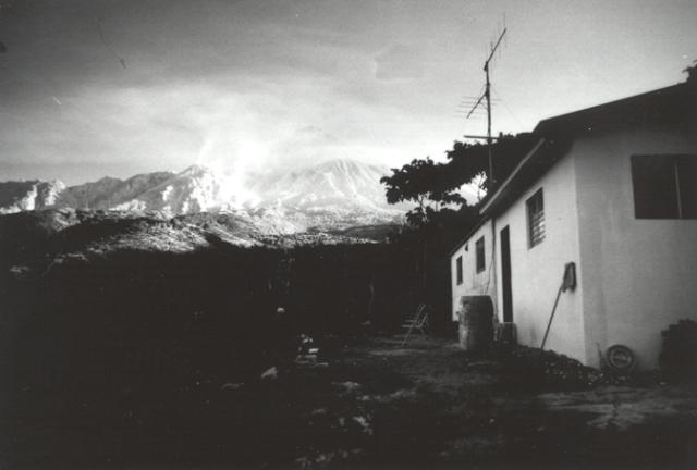 |
Figure 19. Santiaguito Dome complex (left background) with a small plume emerging from Caliente Vent at left-center. Santa María volcano is at center background, partially obscured by clouds. At right foreground is the new Santiaguito Volcano Observatory, at Finca El Faro, [7] km S of the dome. |
Information Contacts: Rodolfo Morales and Gustavo Chigna, INSIVUMEH; William I. Rose, Robert Andres, and Kimberly Kogler, Michigan Tech.
Strong explosion and pyroclastic flow; continued lava extrusion feeds rock avalanches
Quoted material is a report from the Santiaguito Volcano Observatory.
"At 0903 on 10 April, a powerful pyroclastic eruption shook El Caliente vent. The eruption produced a vertical plume that rose 3.5 km above the vent, and a pyroclastic flow that moved a few kilometers down the Río Nimá II. Ash blanketed the area immediately SW to a maximum thickness of 1-2 mm, and noticeable ashfall was observed at Retalhuleu [25 km SSW]. The ash consisted of comminuted dacite, gray to black volcanic glass, plagioclase, and quartz. This eruption marked the first major pyroclastic event at Santiaguito since 23 November 1990 and could signal an increase in hazardous pyroclastic activity similar to the period April-November 1990. Seismic activity increased significantly during the final week of March, following a period of relative quiescence from January through mid-March (figure 20)."
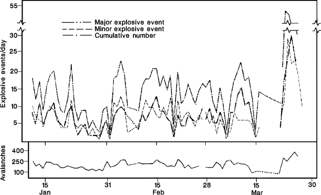 |
Figure 20. Daily explosions and avalanches at Santiaguito, January-March 1991. Dotted lines indicate no data. Courtesy of Otoniel Matías. |
Smaller pyroclastic events, observed during fieldwork 24-27 March and 11-13 April, lasted about 4-7 minutes and were separated by tens of minutes to >1 hour. Eruptive plumes ranged from black to white and rose 500-1,500 m. On 11 April, observers measured a 20° initial eastward inclination of the explosion clouds, and plume heights of 3,000 m. The source of the explosions had migrated about 150-200 m NNE from the summit, which continued to degas quietly.
Numerous avalanches, with 150-400 recorded daily by seismometers (figure 20), occurred on the E flank of the volcano, sometimes accompanied by loud summit explosions. The block lava flow erupting from the E summit of Caliente continued to flow slowly (<100 m/month), with frequent collapses of the flow front sending block-and-ash debris avalanching [into] the Río Nimá II [drainage].
Information Contacts: Otoniel Matías and Rodolfo Morales, INSIVUMEH; Michael Conway, Michigan Technological Univ; P. Vetsch, SVG, Switzerland; Thierry Basset, Univ de Genève, Switzerland.
Explosions and avalanches; plumes to 600 m height
The volcano was in a moderate explosive phase in May, emitting gray ash clouds 300-500 m high. In June, the number of moderate to strong explosions increased daily, with plumes 400-600 m high, and ashfall on the area surrounding the volcano. Numerous collapses and large avalanches were observed on the SE slope.
Information Contacts: Philippe Rocher, L.A.V.E., France.
Continued explosions and block lava production
During a brief visit on 11 September, vertical explosions occurred hourly, producing plumes to about 1200 m height. The block lava flow erupting from the E summit of Caliente continued to flow down to the Río Nima II.
Information Contacts: W.I. Rose, Michigan Technological Univ.
Explosions and block lava flow; continued lahar-induced changes in S-flank drainages
"On 12-14 November geoscientists from INSIVUMEH and Michigan Technological Univ (MTU) spent 3-6 hours/day observing Santiaguito dome. Observation sites included the old Magermann 'Hotel', the Santiaguito Volcano Observatory (figure 21), and a N-S-trending ridge about 1 km E of Caliente vent.
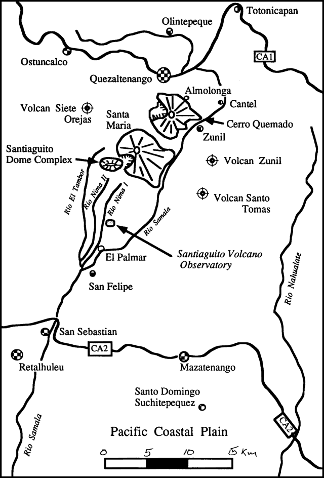 |
Figure 21. Sketch map showing the are around Santa Maria, including adjacent volcanoes and the Santiaguito Observatory. Courtesy of M. Conway. |
"Activity during this period consisted of phreatic (or phreatomagmatic) and magmatic eruptions. Phreatic eruptions were semi-regular during the morning (one every 15-20 minutes from 0700 to 1100) and tapered off somewhat in the early afternoon to one every 30 or 45 minutes. After about 1400, clouds made observations impossible. Phreatic eruptions originated in the open crater of Caliente vent. They generally lasted 1-3 minutes and consisted of a vertical, white to light-gray plume comprised of gas, finely comminuted non-vesicular dacite glass, and subordinate amounts of fine-grained opaque minerals and plagioclase. Plumes typically rose 1-2 km above the vent where they were quickly beheaded and dispersed to the SW by prevailing winds.
"A block lava flow, active for about 16 months, continued to erupt from Caliente vent (figure 22). The flow had recently reached the headwaters of the Río Nimá I, where it changed direction from E to S. Because of constriction of the lava flow at this junction, its front had stagnated and fresh lava was piling up on the upper E flanks of Caliente. This oversteepened lava cap commonly produced small-volume hot rock avalanches; at night, incandescent avalanches were visible [from San Felipe, 14 km SSE]. As lava continued to pile up around the vent, the potential for a [lava flow] collapse increased. Such an event would likely produce a large block-and-ash flow and accompanying ash-cloud surge. In the past, most notably on 19 July 1989 and 19 July 1991, block-and-ash flows entered the Río Nimá drainages and traveled several kilometers downstream. Accompanying pyroclastic surges detached from the flows and traveled E, blowing down trees, scorching vegetation, and blanketing a several-km2 area E of the dome with ash and lapilli. Collapse of the lava flow cap on Caliente's E rim would probably produce similar effects.
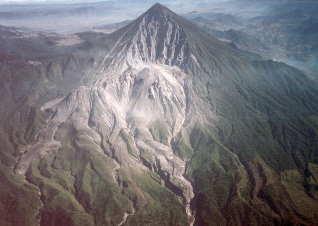 |
Figure 22. Photograph of the Santiaguito dome complex at Santa Maria, February 1991. The dome complex comprises, from west (left) to east (right), El Brujo, El Monje, La Mitad, and the El Caliente vents. The slopes immediately east of El Caliente are covered with tephra from numerous pyroclastic blasts associated with pyroclastic eruptions at El Caliente during the period 19 July 1989 through 1991. It was in this area that four hikers from Quezaltenango were killed by a directed blast. The middle ground is dominated by the 1902 explosion crater of Santa Maria; in the background lies the Quezaltenango valley. Courtesy of Samuel Bonis. |
"Lahars originating near Santiaguito continued to present a serious hazard in the Ríos Nimá I and II and the Río Samalá. The bridge over Río Nimá II at El Palmar, destroyed by a lahar in 1990, has since been replaced by a temporary structure. A lahar destroyed the foot bridge over the Río Samalá near San Felipe in July. The same month, a lahar broke through the perched levees of the Río Nimá II and spilled into the Río Nimá I near Finca Santa Marta ("new channel" on figure 23). The lahar temporarily dammed the Río Nimá I, producing a small reservoir 200 m long and nearly 2 m deep. The new channel linking the Ríos Nimá II and I was about 5 m wide and 6 m deep.
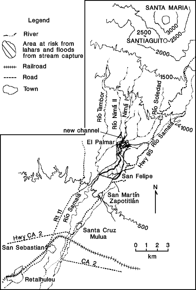 |
Figure 23. Sketch map of rivers and towns S of Santiaguito. Locations of drainages are approximate. Courtesy of Michael Conway. |
"Capture of the Río Nimá II by the Río Nimá I could seriously threaten local communities. In particular, El Palmar, on the E bank of the Río Nimá I, would be endangered by lahars and flood inundation. Furthermore, an increase in the hydraulic load of the Río Nimá I could result in its capture by the Río Samalá at the S end of El Palmar. Such an event would increase the probability of flooding or inundation by lahars downstream in the town of San Felipe. Moreover, a sudden increase in the sediment load of the Río Samalá could lead to temporary damming of the river. This in turn could cause flooding of Finca Las Marías, upstream in the Río Samalá."
Information Contacts: Rodolfo Morales and Otoniel Matías, INSIVUMEH; Michael Conway, Michigan Technological Univ.
Strong gas emission, frequent explosions, and block avalanches from lava dome
During 3 hours of observation following a pre-dawn ascent of Santa María on 4 January, the dome was continuously active, dominantly on its ESE side at Caliente vent. Copious steam emission was continuous from many fumaroles on the E half of the dome, with concentrated emission accompanied by subdued, pulsating roaring from a 25-m-diameter crater at Caliente's summit.
Episodic violent phreatic explosions occurred at intervals of 7-25 minutes, ejecting billowing, cauliflower-shaped steam clouds to heights ranging from 800 to 2500 m above the dome. There was no relationship between repose intervals and the size of subsequent explosions. Each explosion was heralded by a loud roar, lasting 2-4 minutes, from steam jets on the floor or rim of Caliente. Small blocks were commonly ejected onto the E flank of the dome during the early phases of each explosion. Minor ash from dissipating clouds generally drifted SE, lightly dusting vegetation.
Sporadic spalling of large blocks (estimated <=2 m in size) from the dome's E and S flanks indicated that the Caliente lobe was growing by intrusion. One small avalanche of rubble produced an apparent small pyroclastic surge that reached the S foot of the dome. Seared vegetation to several hundred meters SE of the dome suggested that larger pyroclastic surges had recently occurred.
Information Contacts: J.P. Lockwood, USGS; Sección de Vulcanología, INSIVUMEH.
Frequent explosions feed small ash columns; continued erosion threatens vent area
The dome was observed from the old "Hotel Magermann" site and the Santiaguito Volcano Observatory (NW of and 7 km S of the dome, respectively) during 21-24 May fieldwork by Michigan Technological Univ and INSIVUMEH scientists. Between 50 and 100 explosions occurred daily at Caliente vent (figure 24), typically producing relatively weak vertical columns to 500-2,000 m height. The plume was white to light gray, with a small convecting section (100-300 m high) at the base. Fine ash observed several kilometers from the vent consisted of dense, pulverized dacite and fragments of plagioclase; the eruptions were probably phreatic. Between explosions, passive gas emissions rose several hundred meters.
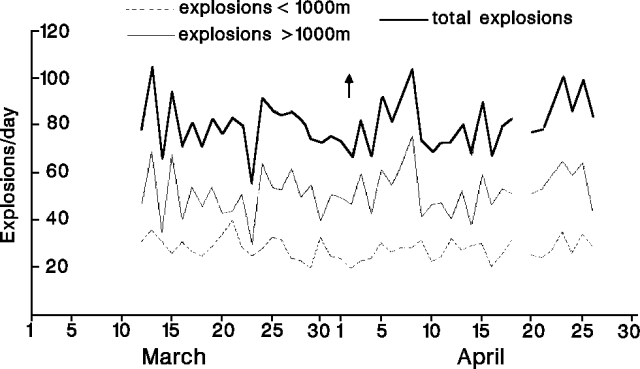 |
Figure 24. Daily number of explosions recorded seismically at Santiaguito, March-April 1992. The arrow marks an unusually strong eruptive event and pyroclastic flow. Prepared by INSIVUMEH. |
Several small, gray, vertical plumes were observed rising from near the SE base of Caliente, probably resulting from collapse at the front of a block lava flow. Although inclement weather prevented closer observation, plume locations suggested that the block lava flow had not progressed far since observations in late November 1991.
An extensive network of gullies, first observed on the N slope of Santiaguito in January 1990, has extended E to include Caliente vent. Rapid mass wasting, which began on the central dome (El Monje), resulted in numerous gullies that coalesced, greatly changing the appearance of the N flank. Scientists noted that continued erosion could severely undercut the large spines on Caliente's upper N flank, possibly causing their collapse and a subsequent rapid depressurization of the shallow magma system beneath Caliente. They warned that sudden depressurization could produce an extremely powerful pyroclastic eruption at the dome. One of INSIVUMEH's goals during its "Decade Volcano" program at Santiaguito is to monitor erosion processes and quantify mass-wasting rates at the dome.
The onset of the rainy season has annually caused an increased number of lahars in drainages S of the volcano. On 20 May, a lahar swept 12 km down the Río Nimá II. Fresh lahar deposits (about 1 m thick) found on terraces above the river's central channel indicated that the lahar was at least 2-3 m thick and 15-30 m wide.
Information Contacts: Michael Conway, Michigan Technological Univ; Otoniel Matías, INSIVUMEH.
Lava effusion and frequent explosions
Frequent phreatic to phreatomagmatic explosions and lava effusion from the currently active Caliente vent immediately SE of the breached summit crater have continued at a less vigorous level than during 1988-91. During the Santa María Decade Volcano Workshop in Quetzaltenango, 7-13 November 1993, activity was observed on several days from the old "Hotel Magermann" site to the NW, from the summit of Santa María, from the Santiaguito Volcano Observatory and from other locations to the S. Participants observed brief explosions from the Caliente vent at intervals ranging from less than a minute to tens of minutes apart. The explosions, less vigorous than during a period of increased activity from 1988-91, ejected white to light-gray convoluting columns of gas and ash to heights of about 100 m to 1 km. Infrequently, larger explosions were accompanied by small pyroclastic flows that traveled several hundred meters, but did not extend beyond the base of the dome.
From the summit of Santa María, three generations of nested craters could be seen at the summit of the Caliente vent (figure 25). The active vent is located immediately below and SE of the Caliente vent complex summit crater, which was breached to the SE by lateral explosions in 1990. A low mound of lava filled the vent and fed lava flows that traveled to the SW, SE, and E. As seen from above, explosions typically began along an approximately 100-m-wide circular arc, apparently defining the upper margin of the vent funnel, and subsequently spread rapidly through the center of the lava mound, vigorously ejecting gas and ash through the highly fractured vent carapace with little noticeable block ejection. Sounds like a jet aircraft continued for up to several minutes after the eruptions.
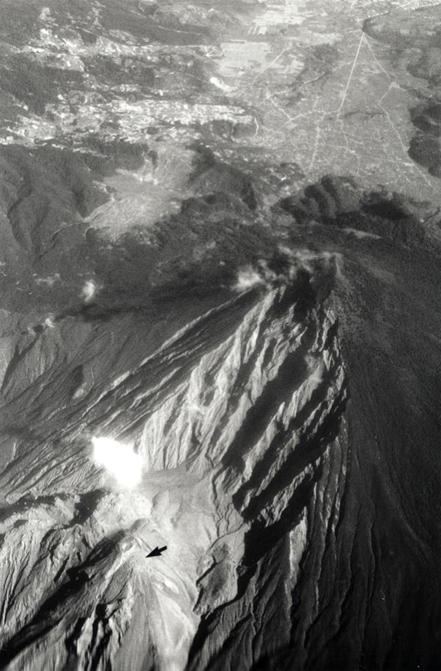 |
Figure 25. Oblique aerial photo of Santa María volcano (3,772 m) from the S, 12 November 1993. The ~2,500 m Santiaguito lava dome complex lies at the lower left, at the base of the extensively gullied 1902 Santa María explosion crater. The currently active Caliente vent (arrow) is located immediately below the circular summit crater of Caliente. The Caliente vent feeds lava flows to the SW, SE, and E. The outskirts of the city of Quetzaltenango lie at the extreme upper right. Photograph by Steve O'Meara. |
By May 1992 the SE lava flow that began in December 1990, following the path of an earlier 1990 lava flow, had intersected the valley wall beneath the SE wall of the 1902 crater and been diverted to the SW along the headwaters of the Río Nimá II. As of November 1993, the lava flow had reached a distance of about 1 km from the vent; occasional hot avalanches from the lava flow reached the base of the dome. A smaller blocky lava flow filled about the upper 300 m of an avalanche channel formed in September on the SW side of Caliente, immediately E of the 1986-88 lava flow, and a third flow extended about 100 m to the E.
Collapse of the SSW side of the crater in September 1993 created the new avalanche channel and produced a pyroclastic flow that divided around a dome buttress immediately below the summit of the Caliente vent. The flows traveled 3 km down the Río Nimá II (figure 26), burning vegetation 100-150 m from the flow margin.
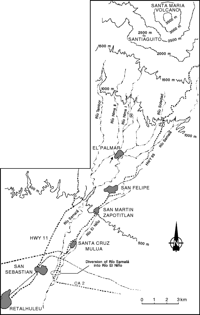 |
Figure 26. Sketch map of rivers and towns S of Santiaguito showing the location of the 28 August 1993 diversion of the Río Samalá into the Río El Niño. Locations of drainages are approximate. The location of the former confluence of the Río Nimá I and Río Nimá II near El Palmar is marked with an arrow. Santiaguito Volcano Observatory is delineated by the circled X. |
The daily frequency of explosions as recorded on seismograms at the Santiaguito Volcano Observatory increased from about 20-60 in July to 60-110 in August (figure 27); data were unavailable for other months. In August, blocks and ash from smaller pyroclastic flows produced by collapse of the lava flow overtopped the ridge above the headwaters of the Río Nimá II SSE of Caliente.
 |
Figure 27. Daily number of explosions from Santiaguito July to August 1993. Arrow marks date of pyroclastic flow. Data not available for other months. Courtesy of Otoniel Matías (INSIVUMEH). |
Extensive gullying on the N side of Santiaguito, first reported in February 1990 (15:03), was continuing. El Monje and La Mitad domes were extensively gullied and less-pronounced erosion had affected Caliente and El Brujo domes. Laharic stream deposition below the N flank of El Brujo dome had widened beyond that shown in previous reports (see figure 18). The stream deposition had formed a pond where the aggraded stream channel blocked the Río El Tambor, which originates above the "Hotel Magermann" on the N. The origin of this increase in mass-wasting remains unclear, but the possibility of a weakened dome infrastructure causing partial collapse and stronger explosions continues to be of concern.
Aggradation of the Río Samalá drainage continues to pose problems for areas below Santiaguito. On 28 August, lahars swept down the Río Samalá, nearly overtopping the Carlos-Castillo Armas bridge on the international highway NE of San Sebastián (figure 26), and covering 200 m of the highway E of town. At peak flow, which lasted 2-3 hours, water filled the 6-7-m-deep channel to within 50 cm of the bridge. The lahar raised the bed of the Río Samalá below the bridge, temporarily diverting the river across the highway into the Río El Niño to the E. In November, boulders up to 2.5 m in diameter continued to block one lane of the highway. Lahar deposits were present S of Las Pilas, about 35 km SW of Santiaguito, and thin deposits of hyperconcentrated flows were found nearly to the Pacific coast.
Active downcutting of the Río Nimá II, which now flows in a channel 6-10 m deep, is continuing above the village of El Palmar (figure 26), 10 km S of Santiaguito. Since late 1991, the channel of the Río Nimá II has migrated about 100 m to the W of its previous course within perched levees immediately W of El Palmar, lessening somewhat the risk of capture of the Nimá II by the Río Nimá I and diversion of debris flows into the more populated Río Samalá drainage.
Rainy season lahars in 1992 did not overrun the international highway, but they filled a gorge 15-20 m wide and 40 m deep S of Las Pilas, and destroyed a bridge about 40 km SW of Santiaguito. The 200 residents of Colonia de San Jose Delicias, S of Las Pilas, heard the advancing lahars during the night and evacuated the village. Upon returning in the morning they found their homes buried up to window level.
Information Contacts: Otoniel Matías, INSIVUMEH; Tom Pierson, USGS; Lee Siebert, SI; Stephen O'Meara, Sky & Telescope, USA.
Small explosion from Santiaguito dome
The main crater (Caliente) of Santa María's active dome, Santiaguito, issued a 300-m-high explosion at 0631 on 14 October. Ash from the explosion blew E and small avalanches traveled down the E and S flanks. Brief explosions from the Caliente vent at Santiaguito were last reported in November 1993. However, it is likely that there has been near-continuous low-level activity since that time.
Information Contacts: Eddie Sánchez and Otoniel Matías, INSIVUMEH.
Ash emissions and small collapses at Santiaguito dome
Santa María's large SW-flank crater that formed in a major eruption in 1902 contains Santiaguito, a dacite dome active almost continuously since 1922. In accord with this pattern, a small explosion was observed on 14 October. During 19 November-12 December 1996 several explosions of moderate-to-high intensity occurred almost daily. These explosions, three per hour, expelled ash in columns that rose variably 300-1,000 m above the active Caliente cone. The ash plumes, white-to-dark-gray in color, remained 8-15 minutes above the volcano before being blown W or SW or both directions. Light ashfalls were reported in the Rosario Palajunoi Estate (15 km from the volcano), La Finca Estate (~7 km SSW of the cone), over the woods in Siete Orejos area, but mostly in the proximity of Caliente cone.
Some of the explosions triggered small collapses and avalanches of blocks and ash down the Nimà Segundo river (SE flank) and along a channel opened by lava flows on the E flank of the volcano.
Information Contacts: Otoniel Matías, INSIVUMEH.
Reports of 6 February dome collapse proven false
Reports of a significant dome collapse at Santiaguito on 6 February were proven false during investigations conducted by geologists from the Instituto Nacional de Sismología, Vulcanología, Meteorología e Hydrología (INSIVUMEH). It is likely that minor downslope movement of loose debris near the summit caused the report.
At 1900 and 2100 on 11 February, local residents from farms S of the dome saw a significant dacitic lava flow.
Information Contacts: Otoniel Matías, INSIVUMEH, Guatemala; Barry Cameron and Shane Rundle, Northern Illinois University, USA.
Explosions, lava flows, and lahars; summary of 1995-98 activity
Explosive activity and lava extrusion from the Caliente vent of the Santiaguito lava dome complex on the SW flank of Santa María continued in January 1999. Explosive activity in January was smaller (with plumes 150-500 m in height) following strong activity in November 1998 (see below). Recent plumes differed from typical explosive activity at Santiaguito; white-to-gray plumes, sometimes partially translucent, were denser and did not disperse rapidly, but draped the flanks of the dome. The lava flow extended ~500 m SW of the vent and had an oversteepened flow front, which periodically collapsed forming small pyroclastic flows and plumes 400-500 m high.
Summary of activity 1995-98. Frequent small-to-moderate explosive eruptions from Caliente vent accompanied by lava extrusion, periodic small pyroclastic flows, and lahars, took place throughout the 1990's. Lava extrusion down the ESE flank of Caliente that began in 1991 continued until 1995, gradually filling the barranco at the head waters of Río Nimá II (figure 28). In September 1995, the lava flow stopped after overtopping the barranca wall and spilling into the Río Nimá I drainage. From September 1995 until May 1996, lahars from the lava spillover traveled down the Río Nimá I, depositing fine sediments.
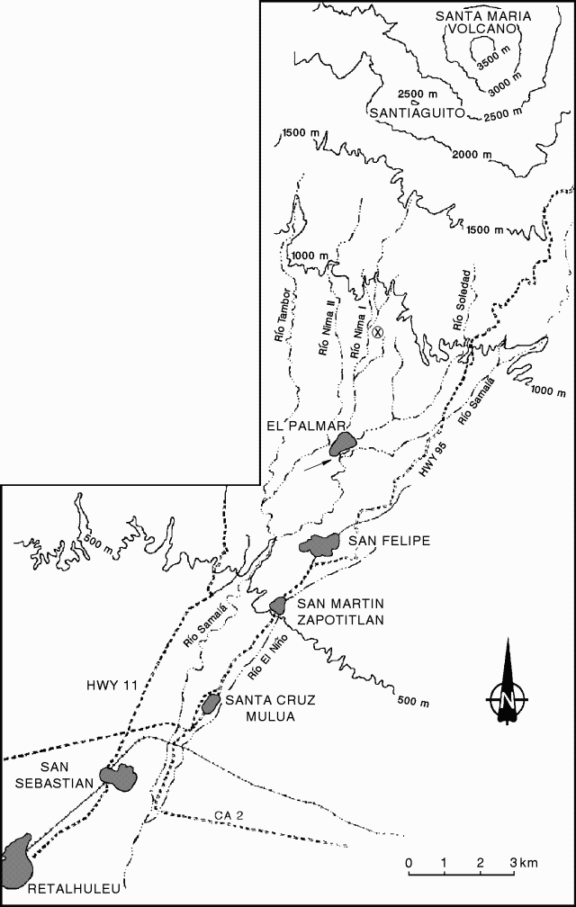 |
Figure 28. Sketch map of rivers and towns S of Santa María. Locations of drainages are approximate. Santiaguito Volcano Observatory is delineated by the circled "x" (~ 3 km N of El Palmar). The arrow below the abandoned town of El Palmar indicates where the Río Nimá I diverted into the Río Samalá. Courtesy of INSIVUMEH. |
Lava extrusion resumed in March 1996, shifting to an easterly direction. The first large lahar down the Río Nimá I took place on 17 May 1997. Lahars 5 m deep swept down the river, destroyed a bridge at Finca El Faro, and deposited 20-25 cm of sediment at the village of El Palmar, 10 km S of Santiaguito. Ten additional lahars took place from May to September 1997.
In 1998 continued lava extrusion into the Río Nimá I contributed to the generation of lahars downstream. From March to May 1998 the government dredged the river from 200 m above to 800 m below the bridge to protect the downstream towns of San Sebastian and Retalhuleu. The major highway was repeatedly overrun and then cleared.
On 28 May 1998, a large lahar descended the Río Nimá I and entered the N end of El Palmar, depositing 40 cm of fine sediment in the streets. The lahar was 7 m deep when it passed the Santiaguito Volcano Observatory, ~6 km S of Santiaguito. About 60 families were evacuated from El Palmar during the lahar, which was reported to be as loud as a jet engine; there were no fatalities. Following the May lahar the government declared El Palmar to be uninhabitable and the village was moved E across the Río Samalá.
From May to September an additional 12-15 lahars raised the river bed. From May to August, 5 m of hyperconcentrated-flow deposits were deposited in the Río Samalá above and below the town of San Felipe.
In August the largest lahar swept through the abandoned El Palmar, covering the S end of the town and destroying the cathedral, leaving only the front tower and the back wall standing. The lahar was 7 m deep and deposited about 2 m of sediment near the town hall. The Río Nimá I, which since 1991 had been diverted just south of town into the Río Samalá, shifted to a new course directly through the abandoned town. The lahar also produced major sedimentation downstream. Before May there had been 10 m of clearance below the Interamericana Pacifica highway bridge over the Río Samalá, 18 km from Santiaguito. After the August lahar there was only 1.5 m of clearance.
In November 1998 lahars down the Río Nimá I filled the channel above Finca La Mosquela, north of El Palmar, covering coffee plantations. There were, however, no major lahars resulting from Hurricane Mitch. The channel of the Río Nimá I, which in 1997 was ~12 m deep and 4-5 m wide at Finca Faro, below the Observatory, is now 15-20 m wide and 3-5 m deep. Farther downstream, between Finca La Mosquela and Finca Santa Marla, above El Palmar, the channel is only 1-3 m deep.
A strong effusive pulse began in November 1998, the first major magmatic event at Santiaguito since the explosions of 1989 and 1990. On 4 November a new lava flow began descending the SW flank of Caliente. Rapid effusion formed a cupola over the vent that collapsed repeatedly 8-20 November, producing pyroclastic flows in all directions, but principally SW. Pyroclastic flows traveled 4-5 km SW and S, and ash clouds rose 2 km. On 11-13 November collapses occurred at intervals of 15-60 minutes. Ashfall was reported in the towns of Retalhuleu and Coatepeque, where 2 mm of dark-gray ash accumulated.
Information Contacts: Otoniel Matías, Instituto Nacional de Sismologia, Vulcanologia, Meteorologia e Hydrologia (INSIVUMEH), Ministerio de Communicaciones, Transporte y Obras Publicas, 7A Avenida 14-57, Zona 13, Guatemala City, Guatemala.
Dome growth, explosions, and related processes in mid- to late 1999
Many dome collapses took place in late July 1999 when the Caliente crater was the scene of repeated pyroclastic flows. Ash columns rose up to ~2.5 km. Dark beige to gray-colored ash fell ~25 km S in Retalhuleu and some fine ash traveled farther still. Dome extrusions also took place; some relatively fluid lavas traveled towards the S.
When visited on 28-29 December, the volcano's activity consisted of weak explosions. Some of these explosions were accompanied by moderate rumbling, weak avalanches, and sizable, active lava flows descending the S flank. A continuous wind, ~35 km/hour, prevailed in the volcano's vicinity.
During 2137-0919 on 29-30 December observers noted four weak explosions. Two of these, at 2137 and 0419, had associated strong tremor and fine gray ash emissions that rose ~50 m and blew W. Visitors also noted a few weak avalanches.
Information Contacts: Eddie Sánchez and Otoniel Matías, Instituto Nacional de Sismología, Vulcanología, Meteorología e Hydrología (INSIVUMEH), Ministerio de Communicaciones, Transporte y Obras Publicas, 7A Avenida 14-57, Zona 13, Guatemala City, Guatemala.
January 2000 lava flow goes 2.5 km down S flank
A blocky lava flow fed from the Caliente vent, active since July 1999 (see BGVN 24:12), had advanced nearly 2.5 km by the end of January 2000. The thermal anomaly related to this flow as measured on the 23 January Landsat 7 Enhanced Thematic Mapper (ETM+) is ~2,370 m long and 60-120 m wide. The flow extended S down the flank of the Santiaguito dome complex before being deflected SW by a low ridge and moving over the top of the 1986-89 flow (figure 29). A ~50 m-wide axial zone of the flow was very steep with a front slope of 60-70°. This ~30-m high axial zone advanced downward and collapsed into the sheer-sided ravine that forms the upper reaches of the Río Nimá II. The marginal flow front is ~18 m thick and its slope is smaller (~32°). As 2- to 5-m-wide sections of the flow front moved, minor collapses occurred at a rate of 1 to 2 per minute. Ash clouds generated by these collapses had temperatures of 185°C, and flow temperatures as high as 531°C were measured at a freshly exposed section of the axial zone. Temperatures for the blocky crust capping the flow front were lower, typically 34-76°C.
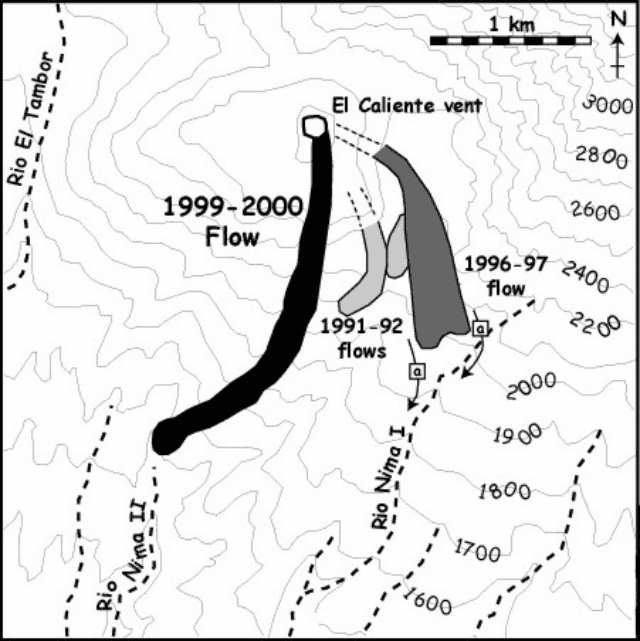 |
Figure 29. Sketch map of Santiaguito showing the January 2000 location of the blocky lava flow that began in July 1999. Also marked are lava flows emplaced between 1990 and 1999, as identified from an analysis of a Thematic Mapper time-series of 13 images. Using this time series the blocky flow which breached the 1902 crater rim is believed to have occurred during 1996-97, where "a" indicates the new aggradation load supply to Río Nimá I. Courtesy of Eddie Sánchez, Otoniel Matías, Andy Harris, Luke Flynn, Bill Rose, James Vallance, Edouard Gegout. |
On 23 January, the Caliente vent was full. The 23 January ETM+ image shows this zone as an intense, thermal anomaly, 120-150 m in diameter. Small ash eruptions occurred at a rate of 1-2 events per hour producing ash plumes that extended kilometers above the vent. More powerful events generated small pyroclastic flows as well as rock falls. Both the dome and upper flow area collapse frequently produced audible rock falls that could be heard from a distance of ~1.5 km. Thirty-seven (37) rockfalls were heard on 23 January; 7 of which were incandescent as hot blocks from the dome and upper flow bounced down the flank of the dome.
Information Contacts: Eddie Sánchez and Otoniel Matías, Instituto Nacional de Sismología, Vulcanología, Meteorología e Hydrología (INSIVUMEH), Ministerio de Communicaciones, Transporte y Obras Publicas, 7A Avenida 14-57, Zona 13, Guatemala City, Guatemala; Andy Harris and Luke Flynn, IGP/SOEST, University of Hawai'i, 2525 Correa Road, Honolulu, HI 96822, USA; Bill Rose, Department of Geological Engineering and Sciences, Michigan Technological University, Houghton, MI 49931, USA; James Vallance, Department of Civil Engineering and Applied Mechanics, McGill University, Montreal, Quebec H3A 2K6, Canada; Edouard Gegout, c/o European Volcanological Society, C.P.1-1211 Geneva 17, Switzerland.
Block lava flow continues, filling in valleys and destroying vegetation
The block lava flow that began to extend S from the Caliente vent during July 1999 (BGVN 24:12 and 25:06) remained active during January 2001. The toe of this active flow reached 3.6 km from the vent, extending down the narrow ravine of the Río Nimá II (figure 30). Across the medial section, the flow had enlarged considerably. At the location of the January 2000 flow front, flow thickness increased from 18 m to 43-67 m according to laser range finder measurements. At this point the flow was also at its widest, with a maximum width of ~510 m, and displayed prominent levees. Where the flow moved alongside the 1902 crater rim, inflation caused the flow top to rise 5-10 m above the rim. Collapses from the flow margins have fallen over this divide and extended into and down the adjacent valley. At the mouth of this valley, pyroclastic-flow deposits mantle vegetation within ~75 m of the valley floor, where upstream facing bamboo stems are charred and smaller bushes have been flattened and imbricated in the direction of flow. At this location a ~30 m deep, marginal ravine has been entirely filled with debris over a 12-month period.
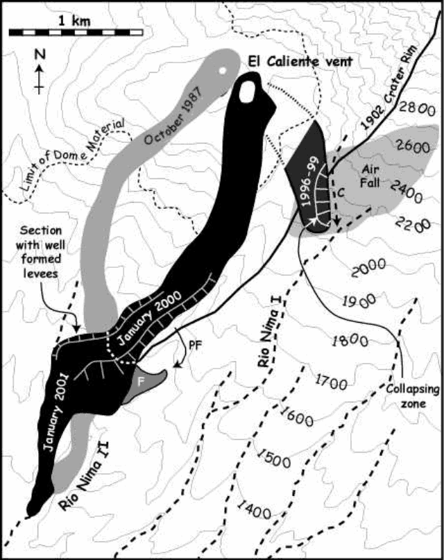 |
Figure 30. Map of Santiaguito dome developed by processing a 25 January 2001 Landsat 7 Enhanced Thematic Mapper Plus image. (C) denotes the new course of streams diverted through the 1902 crater wall by the 1996-99 flow. (PF) marks the course of pyroclastic flows from the block flow medial section, and (F) denotes valley fill observed during ground-based observations of this medial section. Courtesy of the authors (listed below). |
As during January 2000 (BGVN 25:06), the Caliente vent was filled to the brim and the area marked by a low dome feature. Between 0443 and 1105 on 25 January 2001, observers counted 25 small ash eruptions, giving a rate of ~4 per hour. Eighteen of these events were paired, comprised of two emissions separated by 1-3 minutes. More powerful events generated small (less than 400-m-long) pyroclastic flows. During the observation period, both the dome and upper flow zone suffered frequent collapses, with 156 rock falls observed. Of the 23 rock falls observed before sunrise, seven were incandescent.
The now inactive 1996-99 flow (figure 30) is being undercut by the Río Nimá I causing considerable collapse activity. A major collapse at ~0822 on 25 January fed repeated ash clouds that rose ~1 km. Repeated events of this type have removed ~33% of the distal section of this flow in 12 months. Most of this volume has collapsed into the Río Nimá I to feed continued aggradation along this river. Ashfalls from these events mantled vegetation to the E, where the zone of impacted vegetation is readily apparent in figure 30.
The rates of SO2 emission at Santiaguito were measured from a tripod site N of the Finca El Faro on four dates (25 January: 229 metric tons/day; 26 January: 90 metric tons/day; 23 February: 155 metric tons/day and 28 February: 193 metric tons/day). These emission rates represent about twice the average SO2 emission rate over the 20 year period of 1973-93 as determined by Andres and others (1993). The data suggest that SO2 emission rates increase only moderately during periods of elevated dome extrusion rate at Santiaguito.
Reference. Andres, R.J., Rose, W.I., Stoiber, R.E., Williams, S.N., Matías, O., Morales, R., 1993, A summary of sulfur dioxide emission rate measurements from Guatemalan volcanoes: Bull. Volc. 55, p. 379-388.
Information Contacts: Andy Harris and Luke Flynn, HIGP/SOEST, University of Hawai'i, 2525 Correa Road, Honolulu, HI 96822, USA (URL: http://modis.higp.hawaii.edu/); James Vallance, Department of Civil Engineering and Applied Mechanics, McGill University, Montreal, Quebec H3A 2K6, Canada; Mark Davies, School of Environmental Sciences, University of East Anglia, Norwich, NR4 7TJ, United Kingdom; Bill Rose, Gregg Bluth, and Jeremy Shannon, Department of Geological Engineering and Sciences, Michigan Technological University, Houghton, MI 49931, USA; Otoniel Matías and Gustavo Chigna, INSIVUMEH, 7a Av. 14-57, Zona 13, Guatemala City, Guatemala.
Active lava flow front continues to generate ash plumes through early 2002
During early 2002 the block lava flow that began to extend S from the Caliente vent of Santa María during July 1999 (BGVN 25:06) remained active. As of 19 January 2002 the active flow front was in approximately the same location as during January 2001, ~3.4 km from the vent. The active flow front was ~40 m high and extended over an older, now inactive unit. This inactive unit extends 420 m farther down the narrow ravine of the Río Nimá II (figure 31). The flow front was ~315 m wide and was extremely active, being the source of frequent collapse events generating ash plumes that rose ten's to hundred's of meters.
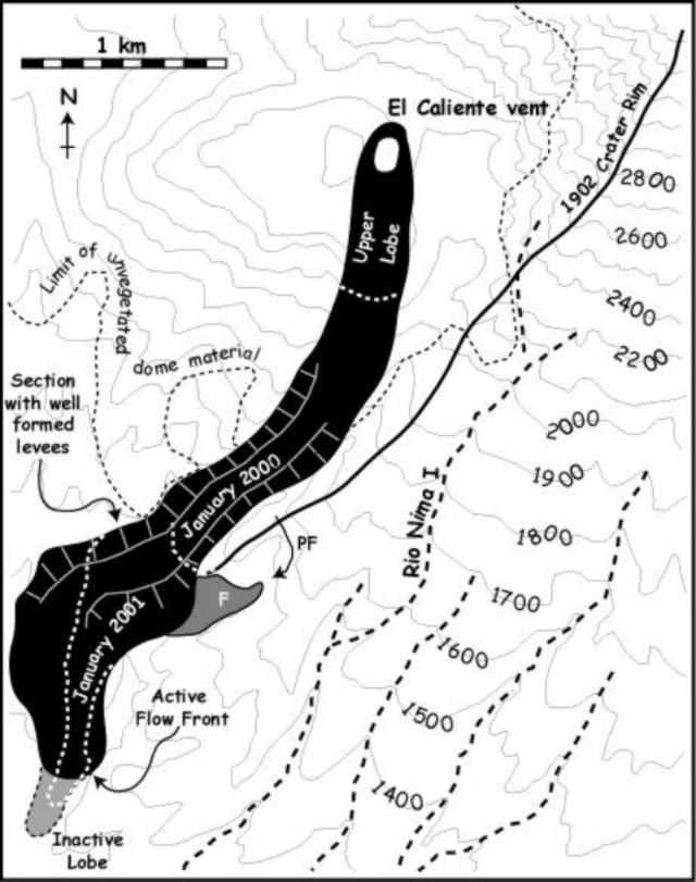 |
Figure 31. Map of the dome of Santa María obtained using a 19 January 2002 Landsat 7 Enhanced Thematic Mapper Plus image. The area shown in black is the extent of the main block lava flow field, along the Río Nimá II ravine, including active and inactive portions. "PF" marks the course of pyroclastic flows from the block-lava flow medial section, and "F" denotes valley fill observed during ground-based observations of this medial section. Courtesy Otoniel Matías, Gustavo Chigna, Yvonne Branan, Lizzette Rodriguez, Gregg Bluth, Matt Watson, Elly Bunzendahl, Janelle Byman, and William I. Rose. |
During a 7.5-hour-long observation period on 10 January, flow front collapses generated ash plumes that reached altitudes sufficient to be observed from 5 km away on 63 occasions. The medial section of the block-lava flow displayed well-formed levees, defining a ~100 m wide channel with typical outer levee heights of 40-75 m. Maximum levee heights of 95-110 m (measured using a laser range finder and using shadows on a Landsat 7 ETM+ image) occurred in the vicinity of the January 2000 flow front location (figure 31). Within the channel, the flow surface was 20-30 m below the levees. The channelized section fed a 300-400 m-wide zone of dispersed flow that extended from the channel mouth to the flow front. This zone consisted of multiple lobes of inactive units, with a central active stream. The distal section was being resurfaced by a new flow lobe. This lobe began extending from the vent around 29 December 2001 and by 19 January 2002 it had extended ~780 m from the vent (advancing at a rate of 65 m per day). The extrusion of this new unit was coincident with a significant explosive/collapse event that generated a small pyroclastic flow down the E flank of the Caliente vent.
As in January 2000 (BGVN, 25:06), the Caliente vent was filled to the brim and the vent area was marked by a low dome-like feature. During 0710-1436 on 10 January, 38 ash eruptions occurred (~5 per hour). Eruptions typically occurred every 30 minutes. However, 10 of these events were paired consisting of two or three emissions separated by 1-5 minutes. Observations from the Santa Maria summit allowed measurements of a ring-shaped (diameter 143 ± 20 m) vent defined by ash-and-gas emissions in the early seconds of brief explosions (figure 32). SO2 flux measurements of the Caliente vent emissions gave large ranges of 15-180 metric tons/day. The larger emission rates are similar to those for the previous two years.
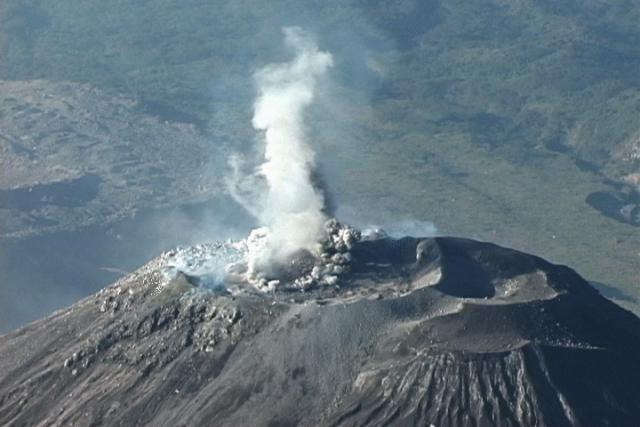 |
Figure 32. View of the Caliente Vent (2,500 m elevation) as seen from Santa María summit (3,772 m elevation) at 0801 on 11 January 2002. The image is part of a digital video sequence at the beginning of an explosive event. The ring-like feature scales to ~ 140 m in diameter. Courtesy Otoniel Matías, Gustavo Chigna, Yvonne Branan, Lizzette Rodriguez, Gregg Bluth, Matt Watson, Elly Bunzendahl, Janelle Byman, and William I. Rose. |
A news article reported that staff from Instituto Nacional de Sismologia, Vulcanologia, Meteorologia e Hidrologia (INSIVUMEH) stated that volcanic activity increased at the Santiaguito dome complex beginning on 11 March 2002. Until at least 14 March near-constant explosions opened fractures on the volcano and emitted ash. Ash rose to 600-900 m above the volcano and fell in the towns of Retalhuleu (25 km SSE of the volcano) and San Marcos, and towards the Mexican border.
Based on information from INSIVUMEH, the Washington VAAC reported that light ash fell near Santa Maria's summit on 13 May and an ash cloud was visible on satellite imagery drifting SW during the morning and more towards the W later in the day. The thickest ash was located very close to the summit, with light ash extending SW.
Information Contacts: Andy Harris, Luke Flynn, and Mark Davies, HIGP/SOEST, University of Hawai'i, 2525 Correa Road, Honolulu, HI 96822, USA (URL: http://modis.higp.hawaii.edu/); Otoniel Matías and Gustavo Chigna, INSIVUMEH, 7a Av. 14-57, Zona 13, Guatemala City, Guatemala; Yvonne Branan, Lizzette Rodriguez, Gregg Bluth, Matt Watson, Elly Bunzendahl, Janelle Byman, William I. Rose, Department of Geological Engineering and Sciences, Michigan Technological University, Houghton, MI 49931, USA; Simon Carn UMBC, Baltimore, MD USA; Washington VAAC, Satellite Analysis Branch (SAB), NOAA/NESDIS E/SP23, NOAA Science Center Room 401, 5200 Auth Road, Camp Springs, MD 20746, USA (URL: http://www.ssd.noaa.gov/); Prensa Libre (URL: http://www.prensalibre.com/).
Lahars during January-October 2002; explosions and pyroclastic flows
At Santiaguito, the active lava-flow front continued to generate ash plumes through early 2002 (BGVN 27:05). INSIVUMEH reported that during January-October 2002, activity at Santiaguito included lahars, explosions, growth of the lava dome, and collapses from the Caliente dome. The main lahar during that period occurred on 8 January 2002. Farmers in the Monte Claro area heard rockfalls on the W flank. Field inspections near the San Isidro ravine showed an abundance of material deposited by mudflows and other volcanic debris, mainly fine ash. These deposits formed ash knolls called "hummocks." The San Isidro ravine begins at the Nimá II river, now covered by the SW lava flow, which created a dam ~200-300 m high. A rupture of the dam in the high part of the Brujo dome contributed fine material and blocks to the high-velocity lahar, which traveled ~4 km until it was stopped by old landslide deposits.
At the height of the Property Florida, there are old lahar deposits, possibly from the eruptions of Santa Maria in 1902 and/or Santiaguito in 1929, with blocks of 1, 2, 3, and 5 m in diameter. With the arrival of the rainy season, San Isidro, which became a new channel for lahars from May to October, had at least six "strong" lahars. The active lava flow from July 1999 had stopped its advance in the channel of the Nimá II river as of April 2002.
Since renewal of activity in April and May 2002, a new lava flow had been advancing on top of the high part of the existing lava flow, in front of the Santiaguito viewpoint. This constant movement was filling up the ravine that divided the lava flow from the El Faro farm. The new lava flow quickly built a small lobe reaching ~300 m high. It advanced in a fan shape toward the S and W flanks, with continuous collapses from the front.
A volcanic ash advisory issued on 16 August was based on a report from INSIVUMEH about a dome collapse with some near-summit ash. However, no ash was evident in GOES-8 satellite imagery. After 29 August there were frequent collapses from the crater rim of the Caliente cone, generating pyroclastic flows that extended to the base of the domes. The greatest collapse occurred on 3 October, accompanied by a strong explosion and several pyroclastic flows that descended all flanks of the volcano at high speeds, covering the volcano completely in a few minutes and producing abundant ashfall on the SW flank. During October there were continued collapses of the crater rim.
In the early hours of 17 October the inhabitants of the El Faro and La Florida farms, and areas such as Palmar Nuevo and part of San Felipe Retalhuleu, heard a strong explosion. At OVSAN (Vulcanológico Observatory of Santiaguito Volcano), this activity was felt, and a collapse of the dome from the edge of the crater was seen. After 19 October moderate and strong explosions occurred at a rate of 3-5 per hour, some accompanied by rumblings. There was also an increase in the number of phreatomagmatic ash explosions that sent abundant gray ash 800-1,200 m high, dispersed mainly on the SW flank. In November observers reported constant collapses of the SE and E lava flows. On the morning of 11 November there was a series of collapses from the S lava flow, and heavy ashfall on the seismic station housing.
Information Contacts: Otoniel Matías and Gustavo Chigna, Unit of Volcanology, Geologic Department of Investigation and Services, Instituto Nacional de Sismologia, Vulcanologia, Meteorologia e Hidrologia (INSIVUMEH), 7a Av. 14-57, Zona 13, Guatemala City, Guatemala; Washington VAAC, Satellite Analysis Branch (SAB), NOAA/NESDIS E/SP23, NOAA Science Center Room 401, 5200 Auth Road, Camp Springs, MD 20746, USA (URL: http://www.ssd.noaa.gov/).
Explosions, pyroclastic flows, and night glow in October
Long term eruptive activity at the Santiaguito lava-dome complex of Santa María has continued during 2003 following lahars, explosions, and pyroclastic flows reported during much of 2002 (BGVN 28:05). Plumes identified on satellite imagery between February and September 2003 were described in aviation advisories issued by the Washington Volcanic Ash Advisory Center (VAAC). Regular reports of daily activity provided by the Instituto Nacional de Sismologia, Vulcanologia, Meteorologia e Hidrologia (INSIVUMEH) on their website have been summarized for many days in the second half of October.
Satellite observations, February-September 2003. Based on GOES-8 imagery the Washington VAAC reported that explosions occurred during the evening of 16 February 2003 and the following morning. Plumes rose to 600 m above the summit, forming an ash plume that was visible on satellite imagery. Imagery from GOES-12 indicated an eruption at about 1330 on 23 July. The plume moved W and had largely dissipated by 1615 after extending ~ 80 km. Washington VAAC reported that the volcano had been active in recent days and that INSIVUMEH had reported an ash column rising to ~ 4.6 km altitude, causing ashfall on farms W of the summit.
The Washington VAAC identified another ash cloud in GOES-12 imagery on 14 August from 0715 through 0745 that was ~ 25 km long and 5 km wide. On 28 September the Washington VAAC reported an ash emission, again based on GOES-12 imagery, that reached an estimated 4.3 km altitude. By 1532 the plume appeared to have detached from the summit and begun to slowly dissipate.
Activity observed during October 2003. Weak and moderate explosions on 15 October continued to expel gray ash to heights of 300-600 m, dispersing to the W and SW. At night blocks of incandescent lava were seen down to the base of the Caliente dome. On 17 October, as during 16 October, most of the nearly 50 explosions were considered moderate, generating avalanches of block lava and ash on the SSW flanks and NE of the Caliente cone. However, at 1745 on 16 October, a strong explosion caused the collapse of a sector of the SW flank of the crater, forming a pyroclastic flow that lasted more than 3 minutes and stopped as it neared the front of the active lava flow ~ 4 km S of Santiaguito.
On 21 October, explosions sent gas-and-ash columns 200-700 m high, which were dispersed by winds to the W, causing slight ashfall of very fine particles to fall in the dome complex. During the night of 22-23 October incandescence on the edge of the crater rim of Caliente cone was observed. Avalanches lasting 3-4 minutes continued with abundant block lava and ash descending primarily down the SSW flank with a minor component to the NE. The ash columns tended to be carried W, causing fine ashfall in sparsely populated mountainous areas. On 24 October there were 26 moderate explosions, 41 weak ones, and about 20 avalanches of lava blocks and ash originating from the S edge of the lava dome in the Caliente cone crater and from the edge of the active lava flow.
During the night of 27 October incandescence along the edge of the lava dome was observed, and weak white fumarolic emissions reached ~ 200 m above the crater in the morning; explosions and avalanches persisted. On 29 October, predominantly moderate and weak explosions produced columns 200-700 m high, and very fine ash fell in nearby mountainous areas. Many of the moderate explosions produced avalanches of block lava and ash to the NE and SW. On 30 October, three small collapses of large blocks occurred from the crater rim, and more than a dozen avalanches, each preceded by explosions and lasting 2-3 minutes, produced abundant fine ash that partially covered the S flank.
Information Contacts: Instituto Nacional de Sismologia, Vulcanologia, Meteorologia e Hidrologia (INSIVUMEH), Unit of Volcanology, Geologic Department of Investigation and Services, 7a Av. 14-57, Zona 13, Guatemala City, Guatemala (URL: http://www.insivumeh. gob.gt); Washington VAAC, Satellite Analysis Branch (SAB), NOAA/NESDIS E/SP23, NOAA Science Center Room 401, 5200 Auth Road, Camp Springs, MD 20746, USA (URL: http://www.ssd.noaa.gov/).
Continued frequent ash explosions and lava-dome collapses
Recent activity at Santa María has been characterized by weak-to-moderate explosions producing ash, crater-rim collapses and avalanches of block lava and ash, pyroclastic flows, and an active lava flow (BGVN 28:10). Activity was similar from October 2003 to June 2004, consisting mostly of explosions from Santiaguito, a lava-dome complex that includes the Caliente vent. The explosions produced ash plumes, and there were numerous block-lava-and-ash avalanches from Caliente collapses.
Activity during October-November 2003. Instituto Nacional de Sismologia, Vulcanologia, Meteorologia e Hidrologia (INSIVUMEH) reported frequent explosions during October 2003 (BGVN 28:10). The Washingon VAAC noted low-level ash plumes visible in 31 October satellite imagery.
As of 17 November, according to INSIVUMEH, several weak-to-moderate eruptions from the lava dome complex sent plumes to ~ 700 m above the crater that drifted SW. According to the Washington VAAC, a pilot saw a plume above Santa María on 16 November; the narrow plume was visible on satellite imagery extending ~ 35 km W. Small eruptions on 18 and 23 November produced local tephra fall. Small avalanches occurred on 18 November. On 24 November five explosions occurred at 1-minute intervals, producing an ash-and-gas plume that rose to 2 km above the crater and dispersed up to 12 km SSW.
On 28 November the seismic network recorded several explosions. INSIVUMEH noted that many of the explosions were followed by block-and-ash avalanches, which traveled SW and S down the Caliente dome. At least five collapses of megablocks from the S rim of the active vent generated short pyroclastic flows to the base of the Caliente dome. On 1 December ash emissions drifted SE and nearly constant avalanches occcurred in the active lava-flow area.
Activity during December 2003. During 7-9 December, frequent, small explosive eruptions expelled ash to less than 1 km above the crater that dispersed to the NW. Moderate-sized avalanches from the S and SE sides of the dome were recorded during the same time period. Weak-to-moderate explosions continued during 10-16 December. On 10 December ash mainly drifted SE toward Santa María de Jesús and las Majadas. Avalanches traveled S and SW from the fronts of lava flows. According to the Washington VAAC, on 12 December ash clouds were visible on satellite imagery at an altitude of ~ 4.5 km, drifting SW.
During 18-22 December, weak-to-moderate explosions caused plumes to drift mainly S and SE towards the Monte Claro, Monte Bello, La Florida, and El Faro fincas (ranches). Nearly constant avalanches traveled S and SW from the fronts of lava flows. Based on information from Retalhuleu airport, the Washington VAAC reported a minor emission on 18 December. No ash was visible on satellite imagery.
On 30 December more weak-to-moderate explosions sent ash-and-gas plumes 500-700 m high. They drifted SW and deposited fine ash in a mountainous region with several ranches. Avalanches continued to spall off of lava-flow fronts on the volcano's SW and S flanks and occasionally from the Caliente dome.
Activity during January 2004. According to seismic data, during 1-5 January weak-to-moderate explosions occurred, causing block-and-ash avalanches to travel 100-250 m down the volcano's SW and S flanks and the Caliente dome. Small amounts of ash fell around the volcano.
During 7-12 January, several weak-to-moderate explosions and avalanches occurred. A partial lava-dome collapse on 7 January produced avalanches down the SW flank. Many of the avalanches were moderate to strong, lasting 1-2 minutes as they traveled SW and S down Caliente dome. Explosions on 12 January produced plumes to ~ 500 m above the volcano. Ash plumes were also visible on satellite imagery several days during the report period.
On the morning of 15 January a moderate explosion at the dome caused a collapse at the edge of the crater. Volcanic material traveled down the SW flank, reaching the base. Ash rose ~ 900 m above the crater and fell on the observatory. Weak avalanches occurred in the SE portion of the lava dome. On 19 January moderate explosions occurred and avalanches descended the lava dome. The plumes produced from the explosions traveled E, depositing small amounts of fine ash around the volcano, including on the ranches of San Jose, Quina, and San Juan Patzulín.
During 21-27 January, weak-to-moderate explosions continued. Avalanches of blocks of lava and ash descended the S and SW flanks of the Caliente dome and explosions produced low-level ash plumes. Small-to-moderate explosions continued during 28 January to 2 February. During 31 January to 2 February, collapses occurred at the SW edge of the lava dome within the Caliente dome. Ash plumes rose to ~ 1 km above the lava dome, accompanied by small avalanches of blocks and ash. According to the Washington VAAC, on 2 February ash plumes were visible on satellite imagery rising to ~ 1 km above the volcano.
Activity during February 2004. During 4-9 February, small-to-moderate explosions occurred, and relatively weak avalanches traveled down Santa María's SW flank. According to the Washington VAAC, ash plumes were visible on satellite imagery on 5 February ~ 2.3 km above the volcano. INSIVUMEH reported that on the morning of 8 February, an explosion produced an ash-and-gas cloud that rose 1-1.3 km above the volcano and drifted WSW.
During 11-16 February, small-to-moderate explosions produced ash plumes to a maximum height of 1.4 km above Santa María. In addition, avalanches went down the volcano's SW flank. Explosions on 16 February deposited fine ash up to 12 km SW. Moderate explosions continued on 19 February. Plumes rose 0.7-1 km above the volcano and mainly drifted SSW as fine ash fell in the mountainous region around the volcano. On 23 February, avalanches of lava blocks and derived ash moved SW down the dome.
During 25 February to 2 March, weak-to-moderate explosions continued. Ash-and-gas plumes rose to ~ 1.4 km above the crater, and ash fell in the mountainous region around the volcano. Weak-to-moderate avalanches of volcanic material was shed from lava-flow fronts.
Activity during March 2004. During 4-9 March, small-to-medium explosions occurred, producing ash-and-gas plumes to 1.5 km above the crater. Avalanches traveled S and SW. Small-to-medium explosions continued during 10-15 March, producing ash-and-gas plumes to ~ 1.3 km above the crater. A small partial collapse on 10 March sent pyroclastic flows down the SSW flank. During the rest of the period, weak avalanches traveled S and SW.
During 15-23 March, several small-to-medium explosions produced ash-and-gas plumes to ~ 1.5 km above the crater. Incandescent avalanches traveled SW from the lava dome. In addition, ash fell in proximal areas. A partial lava-dome collapse on 17 March sent a pyroclastic flow down the volcano's flanks. Weak to moderate explosions produced plumes up to 1 km high during the week of 24-30 March. Light ashfall occurred in nearby areas on several occasions. On 25 March incandescent avalanches from the S flank of the Caliente dome flowed to the SE. Lahars descended the Nimá I river on 28 March and the Nimá I and Nimá II rivers on the evening of 29 March.
Activity during April 2004. During 31 March to 6 April, weak-to-moderate explosions continued, producing plumes to 1.3 km above the volcano. Several partial lava-dome collapses produced avalanches down the S flank. A strong explosion on 1 April caused a collapse and produced a pyroclastic flow that moved ~ 4 km SW toward the Nimá II river. On 12 April weak-to-moderate explosions sent plumes 500-800 m above the volcano. Avalanches of lava blocks and ash traveled down the S flank.
On 18 April, explosions at the lava dome produced ash-and-gas plumes that rose up to ~ 0.8 km above the vent. Small avalanches of incandescent lava also descended the SW side of the Caliente dome. On 19 April, an ash-and-gas plume rose to ~ 4.5 km altitude and drifted SW.
During 22 April-4 May, explosions produced ash-and-gas plumes that rose to ~ 1 km above the crater. Small incandescent avalanches descended the SW side of the Caliente dome. An explosion on 27 April produced a pyroclastic flow that traveled ~ 3 km to the SW.
Activity during May 2004. During 5-7 May, weak-to-moderate explosions sent ash-and-gas plumes to ~ 900 m above the crater. Small partial collapses at the edge of the Caliente dome produced incandescent avalanches to the SW. Weak-to-moderate explosions continued during 10-17 May, producing ash-and-gas plumes that rose to ~ 1 km above the crater. Small partial collapses at the edge of the Caliente dome produced incandescent avalanches to the SW. On 17 May a lahar traveled S down Nimá River I.
During 18-21 May, weak-to-moderate explosions produced ash-and-gas plumes that rose to ~ 1 km above the crater. Many of the moderate explosions were accompanied by incandescent avalanches. On 20 May aa small partial collapse at the edge of the Caliente dome produced an incandescent avalanche to the SW base of the dome. Weak-to-moderate explosions during 31 May-1 June produced ash-and-gas plumes that rose ~ 1.5 km above the crater. Small collapses at the edge of the dome sent avalanches of incandescent material down the SW flank.
Activity during June 2004. On 1 June, 33 weak to moderate explosions producing plumes up to 1.5 km above the summit were recorded. Collapses on the SW side of Caliente produced small pyroclastic flows that descended to the base of the Caliente and La Mitad domes. During 6-8 June, many weak to moderate explosions sent ash-and-gas plumes up to ~ 1.5 km above the Caliente dome, along with some avalanches and flank collapses. Moderate-volume lahars descended the Nimá Segundo river and San Isidro ravine on 1 and 6 June, respectively.
INSIVUMEH reported that on 18 June weak-to-moderate explosions sent ash plumes to 0.4-1 km above the crater. The plumes drifted W, depositing fine ash. According to the Washington VAAC, satellite imagery showed three ash emissions on the 18th that rapidly moved W, becoming more diffuse near the Mexican border. Weak-to-moderate explosions occurred during 25-29 June. Plumes rose to ~ 1 km above the crater and there were sporadic, weak avalanches. On 28 June a partial collapse sent material down the W side of Caliente dome for ~ 40 minutes.
Information Contacts: Instituto Nacional de Sismologia, Vulcanologia, Meteorologia e Hidrologia (INSIVUMEH), Unit of Volcanology, Geologic Department of Investigation and Services, 7a Av. 14-57, Zona 13, Guatemala City, Guatemala (URL: http://www.insivumeh.gob.gt/); Washington Volcanic Ash Advisory Center (VAAC), Satellite Analysis Branch, NOAA/NESDIS E/SP23, NOAA Science Center Room 401, 5200 Auth Road, Camp Springs, MD 20746, USA (URL: http://www.ssd.noaa.gov/).
Partial dome collapses in 2004; explosions and ash columns in 2005
Prior to the period covered by this report, recent activity at Santa María was characterized by weak-to-moderate explosions producing ash, crater-rim collapses and avalanches of block lava and ash, pyroclastic flows, and an active lava flow (BGVN 28:10). Activity was similar from October 2003 to June 2004, consisting mostly of explosions from Santiaguito, a lava-dome complex that includes the Caliente vent. The explosions produced ash plumes, and there were numerous block-lava-and-ash avalanches from Caliente collapses (BGVN 29:06). From July 2004 until October 2005, these types of activity continued.
Activity during July-September 2004. During July to September 2004, weak-to-moderate explosions at Santiaguito produced plumes to a maximum height of ~ 1.5 km above the volcano. Frequent avalanches of volcanic material including blocks and ash traveled SE and SW down Caliente cone. In early September 2004, several weak-to-moderate explosions produced ash clouds to a maximum height of 2 km above the volcano. Partial collapses of the lava dome caused pyroclastic flows to travel down the volcano's NE and SW flanks. On 27 September, several avalanches of volcanic material from active lava-flow fronts traveled SW.
Activity during October 2004. During October 2004 moderate explosions produced ash-and-gas plumes that rose to a maximum altitude of 9 km. Explosions on 4 October produced small pyroclastic flows to the SW. On 11 October, a partial lava-dome collapse to the SW produced a pyroclastic flow that traveled toward the Nimá Segundo River. An ash cloud formed that rose to a height of ~ 500 m and covered most of the dome complex. The collapse was preceded by an explosion that produced an ash-and-gas cloud to ~ 1.5 km above the volcano. Small explosions on 12 October produced small lava-dome collapses to the SW that generated avalanches of lava blocks and ash.
Small lahars traveled down San Isidro ravine on 14 and 15 October. A small collapse of the SW edge of the lava dome in the Caliente crater produced a pyroclastic flow on 17 October. The flow traveled down the S flank and produced a steam-and-ash plume to a height of ~ 800 m upon contact with dammed water. Instituto Nacional de Sismologia, Vulcanologia, Meteorologia, e Hidrologia (INSIVUMEH) reported that this collapse, like those that occurred on previous days and weeks, was associated with a new cycle of magmatic injection. The Washington VAAC reported that hot spots and plumes possibly containing ash were occasionally visible on satellite imagery on 21 October; imagery on 31 October showed a possible ash-bearing plume at ~ 4.5 km altitude.
Activity during November 2004. During November, weak-to-moderate explosions produced gas-and-ash plumes to ~ 1 km above the volcano. Many explosions were accompanied by block-and-ash avalanches from the NE and SW edges of Caliente dome. The Washington VAAC reported that satellite imagery on 3 November showed a possible ash-bearing plume at a height of ~ 5 km altitude. On 12 November, the collapse of a small sector of the SW edge of the Caliente dome produced a pyroclastic flow. On 14 November at 2012, a tectonic earthquake caused a lava-flow collapse SW of the Caliente dome, triggering a pyroclastic flow that descended to the head of San Isidro ravine, an area of abundant accumulation of pyroclastic material and a known area for lahar initiation. During December, weak-to-moderate explosions produced plumes to a maximum height of 1.3 km above the crater. Frequent block-lava avalanches traveled down the SW flank of Caliente dome. A moderate explosion on 4 December caused a partial lava-dome collapse and a pyroclastic flow that traveled SW. On 22 December small collapses occurred from lava-flow fronts on the SW side of Caliente dome. According to the Washington VAAC, ash plumes were visible on satellite imagery on several days during 22-27 December.
Activity during January-October 2005.During January 2005, frequent explosions (table 2) produced columns of gray and white ash up to 2 km in height, ash fall in towns near the volcano and frequent blocky avalanches. Early in the month, avalanches of incandescent blocks were released from lava flow fronts towards the NE and SE flanks of Santiaguito.
Table 2. Explosions recorded at the Santiaguito cone of Santa María in January 2005. Missing dates were not reported. Courtesy of INSIVUMEH.
| Date | Number of Explosions |
| 04 Jan 2005 | 93 |
| 07 Jan 2005 | 62 |
| 10 Jan 2005 | 31 |
| 11 Jan 2005 | 20 |
| 12 Jan 2005 | 14 |
| 13 Jan 2005 | 13 |
| 14 Jan 2005 | 15 |
| 24 Jan 2005 | 16 |
| 25 Jan 2005 | 56 |
| 26 Jan 2005 | 16 |
| 27 Jan 2005 | 52 |
| 28 Jan 2005 | 65 |
During February 2005, frequent explosions and avalanches continued. On 10 February 2005 the Washington VAAC reported that satellite imagery showed a plume of ash and steam moving SW from the summit and ash extending 55 km after an eruption around 0645. A continuous plume of ash and steam was emitted after an eruption around 0745 and ash extended around 230 km from the summit moving at 2-50 km/hour.
During March 2005, several weak-to-moderate explosions produced ash plumes to a maximum height of ~ 1.3 km above the dome. Avalanches of volcanic blocks traveled down the E and SW flanks of Caliente dome. On 16 March, small amounts of fine ash fell in Xepax, Xecavioc, Llanos de Pinal, Las Majadas, and Quetzaltenango. During 19-20 March, ash fell to the E in the town of Zunil.
During 21-25 April several explosions at Santiaguito produced ash plumes that rose to ~ 1.2 km above the dome. Lava avalanches occurred down the SW flank of Caliente dome. Explosions on 25 April produced pyroclastic flows that traveled S down Caliente.
Continuing explosive activity from Santiaguito during 4-9 May sent ash columns as high as 1.3 km above the vent. Small collapses at the Caliente dome generated pyroclastic flows 500-3,000 m long. Constant avalanches were reported on 10 May from the lava-flow front and the Caliente dome, along with one small ash explosion. Minor explosions on 13 May sent gray ash plumes 400-600 m high. Avalanches from the SW-flank lava flow continued. Explosions during 17-20 May produced ash clouds to ~ 1 km above the volcano; ash fell 7-10 km from Caliente dome.
During the first week of June 2005, moderate explosions produced plumes that rose to ~ 1.2 km above the volcano. On 2 June, the partial collapse of the lava dome in the crater of Caliente dome generated a pyroclastic flow that traveled ~ 4 km SW. On 22-24 June explosion columns reached ~ 900 m above the crater and extended several kilometers to the SSW and W. On 27 June, in the region of Palajunoj on the SW flank, constant avalanches of lava blocks were observed. During 6-18 July, weak-to-moderate explosions continued , with plumes rising to ~ 1.3 km above the volcano. Throughout July avalanches of volcanic material were produced at the front of an active lava flow, and from the SW edge of Caliente dome.
August and early September reports were unavailable, but during 7-11 September, small-to-moderate explosions at Santiaguito produced plumes that rose to a maximum height of ~ 1.5 km above the volcano on 8 September. On 7 September, a moderate lahar traveled down the volcano's flank. About a dozen pyroclastic flows, and avalanches of volcanic material occurred from the SW edge of the lava dome, and from the front of lava deposits on the SW flank of Caliente dome.
On 26 October 2005 a small eruption produced an ash plume that drifted SW to the Pacific and was recorded on MODIS satellite imagery (figure 33). The Washington VAAC reported a hot spot that lasted for about 6 hours with an estimated plume height of 4.5 km. On 28 October a plume rose to an altitude of ~ 4.9 km.
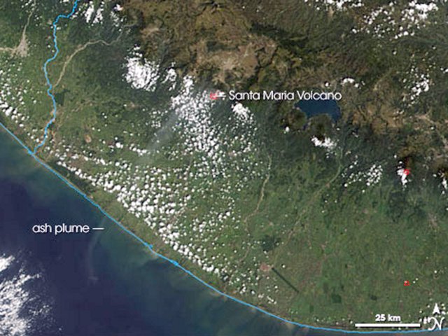 |
Figure 33. MODIS (Moderate Resolution Imaging Spectroradiometer) image showing a Santa María eruption plume on 26 October 2005. The volcano's summit is identifiable by a small red outline indicating an area hotter than its surroundings. Wafting away from the summit is a thin, faint ash plume that heads SW toward the Pacific. NASA image courtesy the MODIS Rapid Response Team at NASA GSFC. |
Information Contacts: Instituto Nacional de Sismologia, Vulcanologia, Meteorologia e Hidrologia (INSIVUMEH), Unit of Volcanology, Geologic Department of Investigation and Services, 7a Av. 14-57, Zona 13, Guatemala City, Guatemala (URL: http://www.insivumeh.gob.gt/); Washington Volcanic Ash Advisory Center (VAAC), Satellite Analysis Branch (SAB), NOAA/NESDIS E/SP23, NOAA Science Center Room 401, 5200 Auth Road, Camp Springs, MD 20746, USA (URL: http://www.ospo.noaa.gov/Products/atmosphere/vaac/); NASA Earth Observatory (URL: http://earthobservatory.nasa.gov/).
During October 2005 to January 2006, occasional ash plumes
This summary of activity at Santa María's Santiaguito lava-dome complex, taken largely from Instituto Nacional de Sismologia, Vulcanologia, Meteorologia e Hidrologia (INSIVUMEH) reported for October 2005 to January 2006. During this interval Santa María continued to emit occasional ash plumes.
During 26-31 October 2005, several explosions took place and plumes rose to a maximum of ~ 5 km altitude on 28 October. In early November, several explosions occurred producing ash plumes to an altitude of ~ 5 km. A few weak avalanches of volcanic material were observed SW of the lava dome.
Explosions produced several ash plumes to ~ 5 km altitude during 11-14 November 2005. Several small pyroclastic flows traveled down the SW, NE, and S flanks of Caliente dome. Frequent avalanches of volcanic material occurred off of the fronts of active lava flows mostly to the W of Caliente dome, and less frequently to the S and NE. An ash-and-gas emission on 14 November produced a cloud that was visible on satellite imagery.
During 17-21 November, Santa María produced weak-to-moderate explosions, sending ash plumes to an altitude of ~ 4.6 km. Several small pyroclastic flows traveled down the SW and NE flanks of Caliente dome, stopping at the base of the dome. Avalanches spalled off of the fronts of active lava flows and traveled SW.
On 24 November at 0955, an eruption produced an ash cloud to an altitude of ~ 4 km accompanied by a pyroclastic flow to the S. Fine ash fell 6-7 km S of the volcano, impacting properties in the area.
Moderate-to-strong explosions in December produced ash plumes that rose ~ 1.5-2.5 km. Pyroclastic flows occasionally accompanied explosions and traveled towards the SW. Several avalanches of volcanic material also occurred during the report period.
Throughout January 2006, explosions continued to occur sending resultant ash emissions to the SW. Lava avalanches originated from the SW edge of the Caliente dome and from the fronts of active lava flows on the SW flank. An explosion on the morning of 11 January 2006 generated a small pyroclastic flow that traveled down Caliente dome to the NE. INSIVUMEH reported on 16 January that a slight decrease in explosive activity was observed during the previous month. On 16 January there were reports of a small amount of ashfall 25 km SW in the urban area of San Felipe Retalhuleu.
During 1-3 February, weak-to-moderate explosions took place at Santiaguito's lava-dome complex, producing plumes that rose to a maximum height of 1 km above the volcano. On 1 February at 0657 and 0708, moderate explosions were accompanied by pyroclastic flows. Lava extrusion at Caliente dome produced block-and-ash flows that descended the dome's S, E, and W sides. Several explosions on 9 February also produced small pyroclastic flows that traveled down the SW and SE sides of Caliente dome. On 15-17 February, pyroclastic flows traveled SW and NE, associated with avalanches of incandescent volcanic material spalled off of active lava-flow fronts.
On 4, 6, and 7 March, satellite imagery showed small ash plumes emitted from the lava-dome complex. The plumes reached ~ 3 km above the volcano. On 6 March around 0733, a moderate explosion produced an ash plume and pyroclastic flows. A strong explosion later that day, at 1025, sent an ash plume ~ 3 km above the volcano that deposited ash throughout the volcanic complex. The explosion was accompanied by pyroclastic flows down the NE and SW flanks. Fine ash drifted S falling on properties in that area. On 12 March, there were avalanches of volcanic blocks and ash. On 13 March, a pyroclastic flow traveled down the S flank of Caliente dome.
Information Contacts: Instituto Nacional de Sismologia, Vulcanologia, Meteorologia e Hidrologia (INSIVUMEH), Unit of Volcanology, Geologic Department of Investigation and Services, 7a Av. 14-57, Zona 13, Guatemala City, Guatemala (URL: http://www.insivumeh.gob.gt/).
Ongoing volcanism, including ash explosions, pyroclastic flows, and avalanches
Activity during late March 2006 through November 2007 at Santa Maria's Santiaguito lava-dome complex included ash emissions similar to those during October 2005-March 2006 (BGVN 31:04). The Instituto Nacional de Sismologia, Vulcanologia, Meterologia, e Hidrologia (INSIVUMEH), the Coordinadora Nacional para la Reducción de Desastres (CONRED), and the Washington Volcanic Ash Advisory Center (Washington VAAC) provided information for this report.
A large number of weak-to-moderate explosions continued at Santiaguito, producing ash plumes that rose above the volcano and depositing ash through the surrounding area. On numerous occasions, short pyroclastic flows and block-and-ash avalanches descended the S and SW flank of Caliente Dome. Several lahars were recorded from June to October 2007 along the Nima I and Samala rivers.
Activity during March-December 2006. A large number of weak-to-moderate explosions occurred during 22-28 March 2006, producing ash plumes that rose to ~ 1 km above the volcano. The plumes drifted SW, depositing ash 8-10 km away. On several days, short pyroclastic flows and block-and-ash avalanches descended the SW flank of Caliente Dome. Explosions on 17 April produced ash plumes 500-900 m high, and pyroclastic avalanches sent material down the S flank.
About two months passed from mid-April until mid-June without reported explosive activity. Then, explosions on 15-16, 18, 21, and 26 June produced gas-and-steam plumes with moderate to no ash content that reached 1 km above the summit. Lahars were observed on 18 and 19 June.
On 1 July small ash plumes noted by the Washington VAAC reached altitudes of 5.8 km and drifted SW. INSIVUMEH reported that another ash plume on 3 July rose 800 m. Steaming from an incandescent avalanche deposit was also visible from the NE base of Caliente cone. Explosions on 9 and 10 August produced gas-and-steam plumes with little-to-no ash content that reached heights of ~ 1.5 km and drifted SW. Two explosions on 21 September caused minor ashfall and small block avalanches. A pyroclastic flow the next day was generated by material coming off of Caliente Dome. Additional explosions on 26 and 29 September again caused ashfall to the SW. Lava extrusion on the 29th triggered avalanches that sent blocks to the base of the crater.
According to the Washington VAAC, minor emissions on 18, 26, 27, and 30 October were visible on satellite imagery. The small plumes of gas and light ash drifted W. Minor emissions seen on satellite imagery on 14 November sent small ash clouds WSW. Explosion plumes reached an altitude of 5.3 km on 15 November, causing ashfall to the N. Lava flows that day moved down the SW, S, and SE flanks of Caliente Dome. On 17 November, explosions produced white-and-gray plumes that drifted SW, where light ashfall was reported. Based on satellite imagery, the Washington VAAC reported more gas-and-ash emissions on 19 November; plumes drifted W.
Satellite imagery revealed ash plumes on 5, 7, and 10 December that drifted SW, NW, and W, respectively. Constant incandescent avalanches on 8 December came from the S and SE edge of dome and from the toe of the active lava flow on the SW flank. Ash plumes caused slight ashfall to the SW. On 28 December a series of small sector collapses from the SW edge of the Caliente Dome produced pyroclastic flows that traveled about 2 km down a ravine. Another collapse produced pyroclastic flows and incandescent blocks on 29 December. Thick ash plumes associated with the pyroclastic flows on both days reached an altitude of 4.3 km and drifted W and NW.
Activity during January-March 2007. Minor emissions of gas and possible ash visible in satellite imagery on 1 and 2 January with narrow plumes drifting WSW were reported by the Washington VAAC. On 4 January there were 37 weak to moderate explosions; the moderate events caused ashfall S and SE in the ranching areas of Monte Bello and Monte Claro. About 21 block-and-ash flows were also observed. Explosions on 5 January produced ash clouds that rose to 4.3-4.8 km, with ashfall noted to the S and SE. Ash puffs were visible on satellite imagery during 7-8 January. Explosions on 12 January sent ash plumes to altitudes of 3.9-4.2 km. Plumes drifted SW and ashfall was reported downwind. Incandescent blocks rolled SW on 12 and 16 January. Based on satellite imagery, diffuse ash plumes identified on 10, 12, and 14-16 January drifted SW and W.
Explosions on 17, 19, and 23 January sent ash plumes to altitudes of 4.1-4.7 km that drifted SW. Incandescent blocks continuously rolled down the S and SW flanks. Based on satellite imagery, the Washington VAAC reported diffuse ash plumes on 18, 24, and 30 January. Explosions produced minor ashfall on 25, 26, and 29 January. Block-and-ash avalanches descended the SW flank of Caliente Dome on 25 and 29 January. Another ash plume on 31 January rose to 4.8 km and drifted SW.
Explosions on 5 February produced ash plumes that rose to altitudes of 4.8 km. On 5 February, plumes drifted SW and S causing ashfall downwind. Block-and-ash avalanches descended the SW and S flanks of Caliente Dome. Fumarolic plumes drifted SW. Based on satellite imagery, the Washington VAAC reported that ash plumes drifted W on 2 February, and that diffuse plumes drifted SW and S in a fan shape on 8 February. A thermal hotspot was also detected on 8 February imagery. Avalanches descended the SW flank to the base of Caliente Dome and explosions produced diffuse ash plumes on 15 February. Explosions on 19 February again produced plumes and ashfall to areas SW.
Diffuse ash plumes seen in satellite imagery drifted mainly W and N during 22, 23, and 25-27 February. Seven explosions on the 26th produced ash plumes that rose to altitudes of 4.4-4.6 km and drifted SW. Avalanches occurred from lava-flow fronts on the SW flanks and from the S edge of Caliente Dome. A hotspot was seen on satellite imagery. On 27 February, explosions occurring at an approximate rate of three per hour produced ash plumes that reached altitudes of 4.8 km. Occasionally explosions were accompanied by pyroclastic flows that traveled SW.
A SW-directed diffuse ash plume on 5 March was followed the next day by another diffuse plume and a hotspot seen on satellite imagery. Explosions produced ash-and-steam plumes that rose to altitudes of 3.8-4.8 km during 21-22 and 25 March and drifted W; ash fell nearby. On 25 and 26 March, avalanches occurred from lava-flow fronts on the SW flanks of Caliente Dome. A 27 March explosion produced a pyroclastic flow that traveled down the SW flank. Explosions produced ash plumes that rose to an altitude of 5 km on 29 March; ashfall was reported near the Observatory Vulcanológico de Santiaguito (OVSAN), about 5 km S. On 30 March diffuse ash plumes were again visible on satellite imagery drifting SW.
Activity during April-June 2007. On 2 April, INSIVUMEH reported that ash plumes rose to 4.4 km and drifted SW. Explosions occasionally produced ash plumes that rose to altitudes of 5.3 km and drifted E on 11 and 16 April. Lava-flow fronts on the SW flanks of Caliente Dome emitted gases on 11 April and produced avalanches of block and ash on 16 April. On 13 April, the Washington VAAC reported that an ash plume was visible on satellite imagery drifting W. Explosions on 20 and 23 April produced ash plumes that rose to altitudes of 5.3 km and caused ashfall up to 9 km SW. On 23 April, lava flows on the SW and NE flanks of Caliente Dome produced small landslides composed of blocks. Diffuse ash plumes were seen in satellite imagery on 18, 23, and 24 April, and gas plumes possibly containing ash on 20 April. Explosions on 26 April produced ash plumes that rose to altitudes of 4.4-4.8 km and drifted SW. More ash plumes and steam-and-ash plumes drifted S and WSW on 26 and 28 April, respectively. On 30 April, explosions caused ashfall to the SW; lava extrusion was low.
Based on satellite imagery, the Washington VAAC reported that ash plumes drifted S on 9 May. INSIVUMEH reported on 10 May that rain caused landslides S down the Nimá I river, near the Observatory about 5 km S of the lava dome. Explosions from Caliente Dome during 10-11 and 14 May produced gas-and-ash plumes that rose to altitudes of 4.4-5.3 km and drifted SW and E. Ashfall was reported from areas S and SW on 10 May. Avalanches of blocks and ash from the SW edge of Caliente Dome were observed on 14 May.
OVSAN and several seismic stations registered a lahar on 5 June. The lahar descended the Nimá I river and carried blocks 1-1.5 m in diameter and tree branches. The approximately 12-m-wide by 3-m-thick deposit was hot and smelled of sulfur. On 7 June, INSIVUMEH reported explosions of steam and ash that rose to altitudes of 4.3-4.7 km and drifted SW. A plume rose from a cooling lava flow at the NE base of the lava dome. Continuous landslides of blocks and ash were noted on the SW flank.
Activity during July-October 2007. During 11-12 July there were 27 seismically-detected explosions. Additional explosions on 13 July produced ash plumes that rose to altitudes of 4.3-5.3 km. Ash plumes from the explosions drifted SW and caused ashfall. Incandescent avalanches of blocks from Caliente Dome were observed.
On 31 August 2007, INSIVUMEH reported that a lahar, 8 m wide and 1.5 m high, descended S down the Nima I river, carrying fine material, tree branches, and blocks. On 25 September 2007 a lahar about 18 m wide descended S down Santa María's Nima I river. On 12 October 2007, lahars in multiple drainages that carried tree branches, fine sediment, and blocks of multiple sizes, flooded the Samala river (to the E and S) as far as the Pacific coast, 70 km S.
Information Contacts: Instituto Nacional de Sismologia, Vulcanología, Meteorología, e Hidrologia (INSIVUMEH), Unit of Volcanology, Geologic Department of Investigation and Services, 7a Av. 14-57, Zona 13, Guatemala City, Guatemala (URL: http://www.insivumeh.gob.gt/); Washington Volcanic Ash Advisory Center (VAAC), Satellite Analysis Branch (SAB), NOAA/NESDIS E/SP23, NOAA Science Center Room 401, 5200 Auth Rd, Camp Springs, MD 20746, USA (URL: http://www.ospo.noaa.gov/Products/atmosphere/vaac/); Coordinadora Nacional para la Reducción de Desastres (CONRED), Av. Hincapié; 21-72, Zona 13, Guatemala City, Guatemala (URL: http://www.conred.org/).
Continuing frequent ash explosions through 2008-2009
Ongoing volcanism, including ash explosions, pyroclastic flows, avalanches, and lahars had continued through November 2007 at Santa Maria (BGVN 32:10). Subsequent activity has been closely monitored by the Instituto Nacional de Sismologia, Vulcanologia, Meteorologia, e Hidrologia (INSIVUMEH), with input from the Washington Volcanic Ash Advisory Center (VAAC).
Activity during 2008. On 11 January 2008, INSIVUMEH reported constant avalanches of blocks from the lava flows on the W and SW flanks of Santa María's Santiaguito lava dome complex. Weak-to-moderate explosions produced ash plumes that rose to altitudes of 4.1-4.5 km and drifted SW. On 6 February, weak explosions generated white columns of water and steam and ash that rose ~ 200 m above the crater rim. There were also a few avalanches onto the W flank lava flow. Degassing on 8 February was characterized by steam and gray plumes of fine ash on the SW flank. A significant magmatic explosion that threw fine ash up to ~ 5 km altitude and drifted ~ 4 km to the SW was followed by weak explosions of steam and ash. Avalanches of blocks from the crater rim on 12 February reached the lava flows on the S and SW flanks. Two moderate explosions expelled gray ash up to ~ 4 km altitude that dispersed to the SW.
The Washington VAAC (based on satellite imagery) reported that ash "puffs" from the Santiaguito lava dome complex rose ~ 4.5 km and drifted SW on 1 April, and then rose ~ 4 km and drifted W on 2 April. During 3-7 April, small explosions produced ash plumes; ashfall was reported in surrounding areas. This was followed on 15 April by three explosions expelling ash 300-900 m above the volcano and dispersing 5 km to the SW. Constant avalanches occurred to the W and SW. On 18 April another volcanic ash emission was reported by the Washington VAAC which rose to ~ 4.8 km, drifted SW, and extended ~ 30 km. More weak to moderate explosions occurred on 21 April which expelled gray ash clouds 300-800 m above the crater rim that drifted E. This activity was repeated on 25 April; the Washington VAAC reported an ash emission which rose to ~ 4.8 km and drifted ~ 13 km SW. On 28 April explosions sent ash plumes to an altitude of 4.1 km that drifted W.
Based on observations of satellite imagery, the Washington VAAC reported that ash puffs from the Santiaguito complex drifted NW on 13 May. On 22 May, two explosions were heard and gray ash emissions rose ~ 300-600 m above the crater rim and drifted S and SW, depositing ash in the Palajunoj area. Avalanches of blocks on the SW flanks were seen and heard. A lahar descended the Nima I River to the S on 25 May.
On 3 June, a Special Bulletin was issued to warn of the potential high water conditions in the Nimá I, Nimá II, San Isidro, Drum, Samala, rivers as a result of heavy rains in the area. On 5 June, avalanches were heard on the flanks of the volcano and overflows into the Samal and Mulu Rivers were reported. A lahar on 9 June about 15 m wide and up to 2 m deep descended the Nima I River, carrying blocks up to 1 m in diameter, and smelling of sulfur.
During the morning of 19 June, six weak-to-moderate explosions produced ash plumes that rose to altitudes of 2.8-3.3 km and drifted SW and S. An incandescent lava flow accompanied by constant avalanches of blocks descended the SW flank. On 20 June, five weak-to-moderate explosions expelled gray ash up to ~ 600-800 m above the crater, spreading to the SW over the area of Palajunoj. The lava flow to the SW continued and incandescent lava could be seen at night, accompanied by constant avalanches of blocks and fine ash. A lahar traveled S down the Nima I river, carrying blocks up to 1 m in diameter. These conditions continued through 24 June.
On 4 July, an explosion produced an ash plume that rose to an altitude of 3.3 km and drifted SW. A lahar traveled S down the Nima I River, carrying tree limbs and blocks up to 50 cm in diameter. On 7-8 July, sounds resembling avalanches descending the flanks were reported; visual observations were hindered due to cloud cover. On 22 July seismic stations detected a lahar in the Nima I river. Explosions observed on 23, 28, and 29 July from the Caliente cone produced ash plumes that rose to altitudes of 2.8-3.3 km and drifted SW and W. Ashfall was reported in areas downwind. A lava flow and avalanches of blocks descended the SW flank. On 28 July, weak pyroclastic flows also traveled down the SW flank.
During 21-26 August, explosions from the Caliente cone, part of the Santiaguito complex, produced ash plumes that rose to altitudes of 2.8-3.3 km and drifted S, SW, and W. Constant degassing from the crater was noted.
On 10 September seismic stations detected a lahar in the Nima I River. The lahar, about 18 m wide and up to 2 m deep, carried blocks and smelled of sulfur. During 11-16 September, explosions produced ash plumes that rose to altitudes of 2.8-3.3 km and drifted SW; on 18 September, the Washington VAAC reported that an ash plume rose to an altitude of 4.3 km and drifted SSW. On 24 September explosions produced ash plumes that rose to altitudes of 2.8 km and drifted SW. Avalanches of material from lava flows descended the SW flank.
On 11 and 15 November, the Washington VAAC reported that ash puffs drifted SW. On 12 December, explosions from the Caliente dome produced an ash plume that rose to an altitude of 3.2 km and drifted SW; the Washington VAAC reported a plume to an altitude of 5.8 km. On 16 December, two ash puffs drifted W and WNW at altitudes of 4.3-4.6 km. The Washington VAAC again reported that during 17-20 and 22 December ash plumes drifted SW, W, and NW; plumes rose to an altitude of 5.8 km. On 22 December, white plumes drifted SW and avalanches occurred from the crater rim. On 23 December a small ash plume drifted NW and explosions resulted in pyroclastic flows. Ash plumes rose to an altitude of 3.3 km and drifted S and SW. On 25 December a puff of ash drifted WNW.
Activity during 2009. Activity continued into 2009 and the Washington VAAC reported that two small ash plumes drifted ESE on 1 January. During 4-5 January, gas and steam plumes possibly containing some ash drifted SW and WSW. On 5 and 6 January fumarolic plumes drifted 100 m above the crater. Five explosions produced ash plumes that rose to altitudes of 2.8-3 km and drifted W and SE. A few avalanches originating from a lava flow descended the W flank. Explosions during 30 January-3 February produced plumes that rose to altitudes of 2.6-3.2 km and drifted W, SW, and S. Avalanches that were periodically incandescent descended the S and W flanks of Caliente lava dome.
The Washington VAAC reported that on 4 February multiple ash puffs drifted W. Explosions on 6 February produced plumes that rose to altitudes of 2.8-3.1 km and also drifted SW. Ashfall was reported in areas downwind. Ash puffs on 12 February drifted WSW and W. On 16-17 February, explosions produced ash plumes that rose to altitudes of 2.7-3.3 km and drifted SW. Small pyroclastic flows on 16 February descended the SE flank and reached the Nima I River. Incandescent avalanches were noted on 17 February and fumarolic plumes drifted SW.
On 18 February, a dense ash plume drifted W, and on the 20th an explosion sent an ash plume to an altitude of 3.2 km that drifted E. On 24 February, an explosion produced a white plume that rose 500 m above the summit and drifted SW. Incandescence was seen SW of Caliente dome. On 26-27 February and 2 March, explosions produced ash plumes that rose to altitudes of 2.8-3.4 km and drifted SW. Ashfall was reported in nearby areas. Avalanches were seen SW of the Caliente dome.
Based on satellite imagery, the Washington VAAC reported that during 4-6 March ash plumes drifted W. On 6 and 10 March, ash plumes rose to 2.8-3.4 km and drifted SW, NW, and N. Ashfall was reported in areas downwind. On 12, 16, and 17 March, explosions produced ash plumes that rose to altitudes of 2.7-3.5 km and drifted E and SW. A few avalanches originated from an active lava flow and traveled down the SW flank. On 12 March an ash plume drifted S, and on 15 March, an ash plume rose to an altitude of 3 km and drifted SW and WSW.
During 24-28 April explosions produced ash plumes that drifted 5-8 km WSW, although the number of explosions had decreased during the previous few weeks. On 5, 8, and 9 June ash plumes rose to altitudes of 2.8-3.3 km and drifted SW. Gas plumes that were sometimes gray rose ~ 300-600 m above the Caliente dome, and avalanches descended the S and W flanks. On 26 and 29 June explosions produced ash plumes that rose to altitudes of 2.9-3.3 km and drifted W and SW.
On 26 June, the seismic network detected a lahar that traveled S down the Nima I River. Steam plumes and a sulfur odor rose from the deposits. The lahar was 15 m wide and 1 m thick at the toe, and carried blocks up to 1.5 m in diameter. On 2 July lahars descended both the Nimá I and Nimá II rivers, carrying tree branches and blocks 50-75 cm in diameter. The lahars were 15 and 20 m wide.
On 6 July, explosions produced ash plumes that rose to altitudes of 2.8-3.2 km and drifted W. On 31 July and 3 August, explosions produced ash plumes, and the Caliente lava dome was incandescent. On 3 August, ash plumes rose to an altitude of 3.1 km and drifted W. Fumarolic plumes rose 200 m above the dome and rumbling noises were occasionally heard.
On 28 August, another explosion was noted. On 1 September, fumarolic plumes rose 150 m above Caliente dome and drifted SW and avalanches descended the SW flank of the dome. On 14 September an explosion produced an ash plume that rose to an altitude of 3.3 km. The plume drifted SW and caused ashfall. Avalanches went to the SW.
The Washington VAAC reported that on 22 October multiple ash plumes drifted less than 20 km SW. On 23 and 26 October, explosions produced ash plumes that rose above Caliente dome to altitudes of 3-3.3 km. The plumes drifted W and SE and caused ashfall. Avalanches descended the SW flank of the dome. Degassing sounds resembling airplane engines were also heard.
On 6 November, an explosion produced a plume that rose 900 m and drifted SW. The Washington VAAC reported that on 8 November a small gas plume possibly containing ash drifted less than 10 km SSW. Another small plume was seen later that day. On 13 November, a plume drifted SW. Avalanches descended the SW flank of the dome and the Washington VAAC reported that on 16 November multiple ash plumes drifted WSW.
On 20 November, two explosions produced an ash plume that drifted SW. Avalanches descended the SW flank of the dome. An explosion on 24 November produced an ash plume the rose to an altitude of 3.3 km and drifted SE. Ashfall was reported in areas downwind.
On 11, 14, and 15 December, explosions produced ash plumes that rose to altitudes of 2.8-3.5 km and drifted W and SW. Avalanches occasionally descended the SE flank of the dome. On 15 December, explosions generated pyroclastic flows that descended the E and SW flanks. On 30 December explosions produced ash plumes that rose to altitudes of 3-3.4 km and drifted W and SW. The Washington VAAC reported that ash plumes seen on satellite imagery drifted more than 30 km WSW. Avalanches occasionally descended the SW flank of the dome.
Activity during January-April 2010. Incandescent avalanches traveled down the SW flanks on 8 January 2010. A few explosions on 5 and 11-12 January produced ash plumes that rose to altitudes of 3.1-3.4 km and drifted S, SE, and SW. Avalanches from a lava flow descended the W flank of the dome. On 21 January ashfall was reported in areas near the Santiaguito complex. The next day an explosion produced an ash plume that rose to an altitude of 3.2 km and drifted SW. An ash plume seen on satellite imagery drifted less than 10 km.
On 2 and 4 March, explosions produced ash plumes that rose to altitudes of 2.7-3.1 km and drifted E and NE. Ash fell in areas downwind. Ash fell in inhabited areas downwind. The Washington VAAC reported that on 8 March an ash plume was seen in satellite imagery drifting WNW. On 29 March, explosions produced ash plumes that rose to altitudes of 3-3.3 km and drifted W over inhabited areas. Avalanches from a lava flow descended the SW flank. On 30 March a diffuse ash plume was seen in satellite imagery.
On 20 April, explosions produced ash plumes that rose to altitudes of 2.8-3.4 km and drifted S and SE. On 26 April, ash explosions and pyroclastic flows generated ash plumes that rose to an altitude of 8.3 km and drifted NW and N. Ashfall was reported in Quetzaltenango (18 km WNW) and other areas to the W, NW, and N. According to news articles, schools in 10 communities were closed and flights were banned within a 20-km-radius of the volcano.
Information Contacts: Instituto Nacional de Sismologia, Vulcanología, Meteorología, e Hidrologia (INSIVUMEH), Unit of Volcanology, Geologic Department of Investigation and Services, 7a Av. 14-57, Zona 13, Guatemala City, Guatemala (URL: http://www.insivumeh.gob.gt/); Washington Volcanic Ash Advisory Center, Satellite Analysis Branch (SAB), NOAA/NESDIS E/SP23, NOAA Science Center Room 401, 5200 Auth Rd, Camp Springs, MD 20746, USA (URL: http://www.ospo.noaa.gov/Products/atmosphere/vaac/); Coordinadora Nacional para la Reducción de Desastres (CONRED), Av. Hincapié; 21-72, Zona 13, Guatemala City, Guatemala (URL: http://www.conred.org/).
Eruption on 26 April 2010; ongoing activity through September 2011
The following report provides information from May 2010 through mid-October 2011 on Santa Maria volcano and its active dome complex, Santiaguito. The last report (BGVN 35:03) covered activity form 2008 to April 2010. The sources for this report are Guatemala's Instituto Nacional de Sismologia, Vulcanologia, Meteorologia e Hidrologia (INSIVUMEH) and Washington Volcanic Ash Advisory Center (VAAC). Santa Maria's eruptive history from the Global Volcanism Program database identifies the current eruption as beginning 22 June 1922 and continuing to mid-October 2011. The database's criteria for an eruption ending requires at least a 3-month pause in volcanic emissions (Siebert and others, 2010).
A recent report concerned the eruption of 26 April 2010, an event mentioned at the end of our last report (BGVN 35:03). A table summarizes some significant activity during the current reporting period. It is notable that during about nine months of 2011 (up to early October), MODVOLC measured thermal alerts several times each month (in each instance covering an area of 1 to 3 pixels). In comparison, during 2009, seven thermal alerts were measured and, during 2010, three alerts were measured.
More details on the 26 April 2010 eruption. Chigna (2010) noted the 26 April 2010 eruption of Santiaguito was associated with four large seismic events (M 3.9 at 0624, M 4.92 at 0648, M 5.89 at 0723, and M 5.72 at 0758). The seismic network recently established at the volcano permitted first-time recognition of some seismic signals known as tornillos ['screws' in Spanish; defined by Morrissey and Mastin (2000) as monochromatic, long period seismic events lasting a few minutes, with long codas of progressively decreasing amplitude that may be eruption precursors] (figure 34a). Pyroclastic flows were generated within the gullies on the S flank. An ash column rose to an altitude of 15 km, drifting to the W, NW, N, NE, and E, causing closure of village schools SW of Santiaguito and in the Quetzaltenango area. The ashfall was reported out to 7.3 km from the volcano; civil aeronautics alerted air traffic to avoid the plume within a radius of 80 km.
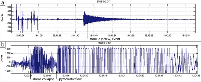 |
Figure 34. Examples of seismic records at Santa Maria. (a) Tornillo (screw) event. (b) Pyroclastic flow due to dome collapse; arrows indicate the onset of the primary events. Both seismic records taken from Chigna (2010). |
Activity from May 2010 to early-October 2011. Tables 3 and 4, summarizing activity from May 2010 through early-October 2011, document nearly continuous explosions, plumes, and pyroclastic flows. Various mass wasting processes were common, particularly block avalanches and lahars, often set into motion by precipitation.
Table 3. Summary of available information on explosions, plumes, and other volcanic emissions of Santa Maria volcano reported during May-December 2010. "--" is 'not reported' in original VAAC reports. Courtesy of INSIVUMEH, Washington VAAC, and MODVOLC.
| Date | Explosions noted | Plume color and composition | Plume Height | Drift Direction | Other Activity |
| 07 May 2010 | 17 weak to moderate | Gray | 2.9-3.4 km | SW | -- |
| 10 May 2010 | -- | White | 75 m | -- | -- |
| 19 May 2010 | Yes | Ash | 2.9-3.4 km | SW | Hot lahars carried blocks |
| 20 May 2010 | Yes | -- | 3.3 km | E | Pyroclastic flow to SW |
| 04 Jun 2010 | -- | -- | -- | -- | Lahar carried blocks |
| 19-20 Jul 2010 | 24 in 48-hour period | Ash | 300-900 m | SE, W | -- |
| 05-06 Aug 2010 | -- | Steam | -- | SW | Lahars carried trees, blocks |
| 01 Sep 2010 | -- | Ash | 100 m | SE | Pyroclastic flow to SW |
| 02 Sep 2010 | Yes | Ash | 500-1,000 m | W, SW | Block avalanches on W flank |
| 06 Sep 2010 | Yes | Ash | 500-1,000 m | W, SW | -- |
| 11 Sep 2010 | Yes | Ash | 1 km | E, SE | Pyroclastic flows (2) to 3 km SW |
| 13 Sep 2010 | -- | White | 100 m | S | -- |
| 22 Oct 2010 | Yes | Ash | 300 m | SW | Block avalanches on S and SW flanks |
| 26 Oct 2010 | -- | Steam | 150 m | -- | -- |
| 29 Oct 2010 | Yes | Ash | 900 m | SW | Pyroclastic flow down SW flank to 5 km S |
| 31 Oct 2010 | -- | Ash | -- | W | -- |
| 17, 22 Nov | Yes | Ash | 0.7-1 km | E, SE | -- |
| 19 Nov 2010 | -- | -- | -- | -- | Ashfall to the S |
| 08 Dec 2010 | Yes | Ash | 700 m | SE | Block avalanches; ashfall to SE |
| 10 Dec 2010 | -- | Ash | -- | 21 km W | -- |
| 13-14 Dec 2010 | Yes | Ash | 300-700 m | SE | Block avalanches; pyroclastic flows |
| 29-30 Dec 2010 | Yes | Ash | 300-600 m | S, SE | Ashfall |
Table 4. Summary of available information on explosions, plumes, and other volcanic emissions of Santa Maria volcano reported during January through early-October 2011. "--" is 'not reported' in original VAAC reports. Courtesy of INSIVUMEH, Washington VAAC, and MODVOLC.
| Date | Explosions noted | Plume color and composition | Plume Height | Drift Direction | Other Activity |
| 01 Jan 2011 | -- | -- | -- | W | Satellite thermal anomalies |
| 03-04 Jan 2011 | Yes | Ash | 700 m | SW | Avalanches to W flank |
| 05-06 Jan 2011 | Yes | Ash | 400-500 m | SW | -- |
| 08 Jan 2011 | -- | Ash? | -- | 30 km SSW | -- |
| 10-11 Jan 2011 | Yes | Ash | 600 m | SW, W | Avalanches on S and E flanks |
| 20-21 Jan 2011 | -- | Ash | 4.3-5.2 km | SW | Avalanches; rockfalls |
| 23-24 Jan 2011 | -- | Ash | 300 m | N | -- |
| 02-03 Feb 2011 | Yes | Ash | 300 m | -- |
References. Chigna, G., 2010, Eruption of Santiaguito (1402-03) 26 April 2010. INSIVUMEH (URL: http://www.insivumeh.gob.gt/).
Morrissey, M., and Mastin, L., 2000, Vulcanian eruptions, p. 463-475, in Sigurdsson, H. (ed), Encyclopedia of Volcanoes, Academic Press, San Diego.
Siebert, L., Simkin, T., and Kimberly, P., 2010, Volcanoes of the World, 3rd ed., Berkeley: University of California Press, 568 p.
Information Contacts: Instituto Nacional de Sismologia, Vulcanologia, Meteorologia e Hydrologia (INSIVUMEH), Unit of Volcanology, Geologic Department of Investigation and Services, 7a Av. 14-57, Zona 13, Guatemala City, Guatemala (URL: http://www.insivumeh.gob.gt/inicio.html); Washington Volcanic Ash Advisory Center (VAAC), Satellite Analysis Branch (SAB), NOAA/NESDIS E/SP23, NOAA Science Center Room 401, 5200 Auth Rd, Camp Springs, MD 20748, USA (URL: http://www.ospo.noaa.gov/Products/atmosphere/vaac/); MODVOLC-HIGP, Hawai'i Institute of Geophysics and Planetology (HIGP) MODVOLC Thermal Alerts System, School of Ocean and Earth Science and Technology (SOEST), Univ. of Hawai'i, 2525 Correa Road, Honolulu, HI 96822, USA (URL: http://modis.higp.hawaii.edu/).
Large May 2014 eruption with ashfall, pyroclastic flow, and lava flow; activity during October 2011-June 2014
This report summarizes activity from Santa María's active cone, Santiaguito, during October 2011-June 2014. Ash explosions, ashfall, and incandescent avalanches were observed throughout this time period. During the rainy season (April-September), lahars were frequently reported within the major drainages in the southern sector of the volcano. The sources for this report were Guatemala's Instituto Nacional de Sismologia, Vulcanologia, Meteorologia e Hidrologia (INSIVUMEH), Washington Volcanic Ash Advisory Center (VAAC), and Coordinadora Nacional para la Reducción de Desastres (CONRED).
Recurrent ash explosions. INSIVUMEH and the Washington VAAC reported frequent ash explosions from Santiaguito's active dome, Caliente, during October 2011-June 2014 (figure 35). Ash plumes were typically in the range of 500 m above the dome with exceptional cases in the range of 4,000 m, such as the explosive event on 9 May 2014. Significant ash plumes were known to drift as far as the Guatemala-Mexico border (such as activity during 5-6 November 2011 when ash extended 18-28 km SE of the summit). Degassing from the Caliente dome also generated frequent, diffuse, white plumes that rose to heights around 200 m above the summit.
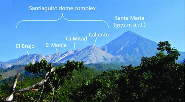 |
Figure 35. The Santiaguito dome complex of Santa María includes four major domes: El Brujo, El Monje, La Mitad, and Caliente (active since 1922). This photo was taken from the INSIVUMEH observatory located on Finca El Faro, ~6 km S of the active dome. Modified from Ball and others (2013). |
Ashfall from explosions and rumbling noises from explosions and avalanches were frequently reported in communities nearby (table 5). Following activity on 9 May 2014, ashfall triggered evacuations affecting ~130 people. CONRED and INSIVUMEH reported that ash had extended up to 20 km from the summit reaching the communities of Las Marías, San Marcos (10 km SW), Palajunoj (18 km SSW), El Faro (SW flank), La Florida (5 km S), Patzulín, and Quetzaltenango (18 km WNW).
Table 5. Ashfall from explosions at Santa María's active dome, Santiaguito, was reported in numerous communities during November 2011-June 2014. Courtesy of INSIVUMEH.
| Year | Date | Town reporting ashfall |
| 2011 | 2 Nov. | Las Marías, El Rosario (45 km SW), San Marcos (46 km NW), Palajunoj (SW), and San Felipe Retalhuleu (25 km SSE of the volcano) |
| 2012 | 19 Jan. | La Florida (5 km S), Palajunoj (SW flank), and San Marcos (46 km NW) |
| 27 Jan. | Monte Claro (S) and Palajunoj (SW) | |
| 1 Feb. | Monte Claro (S) and Palajunoj (SW) | |
| 2-3 Feb. | La Florida (5 km S), San Marcos (46 km NW), and Palajunoj (W) | |
| 23 Feb. | El Rosario (45 km SW), Monte Bello (S), Palajunoj (SW), and Quetzaltenango (18 km WNW) | |
| 27-28 Feb. | Monte Claro (S), San Marcos (46 km NW), Buena Vista (49 km NW), El Rosario, Monte Bello, and Palajunoj | |
| 11-12 Mar. | Observatory Vulcanológico de Santiaguito (OVSAN), the El Faro and Patzulín ranches, and in the village of Las Marías (SW) | |
| 8-9 Mar. | Loma Linda (W), San Marcos (10 km SW), and Palajunoj (W) | |
| 25-27 Mar. | Observatory Vulcanológico de Santiaguito (OVSAN), at the El Faro, La Florida, and Patzulín ranches (SW), and in the village of Santa María de Jesús (SE) | |
| 30 Apr.-1 May | Quetzaltenango (18 km WNW) | |
| 22 May | San Felipe (15 km SSW), El Nuevo Palmar (12 km SSW) | |
| 22 Jun. | Santa María de Jesús (SE) | |
| 1-3 Jul. | Ashfall was reported in La Florida (5 km S) and Monte Claro (S) | |
| 4-6 & 9-10 Jul. | La Florida (5 km S), Monte Claro (S), and Palajunoj (SW | |
| 18-20 Aug. | Monte Claro (S), El Rosario (45 km SW), Palajunoj (S), | |
| 25-26 Aug. | Monte Claro (S) | |
| 27 Aug. | San José (SE) | |
| 21 Nov. | Las Marías, Calaguaché (9 km S), and Nuevo Palmar (12 km S) | |
| 13-14 Dec. | La Florida (5 km S) and El Faro (SW flank) | |
| 2013 | 30 Jan. | Esperanza and San Mateo in Quetzaltenango |
| 7-8 & 10-11 Feb. | La Florida (5 km S) | |
| 23 Feb. | Quetzaltenango (18 km WNW) | |
| 22 Feb. | Monte Claro (S) | |
| 20-21 Feb. | Palajunoj (SW) and La Florida (5 km S) | |
| 6-11 Mar. | Calahuaché, El Faro (SW flank), and San José Patzulín (SW flank) | |
| 19 Mar. | San José (SE) | |
| 17-18 Mar. | Quetzaltenango (18 km WNW) | |
| 13-14 & 25-26 Mar. | El Faro (SW flank) and La Florida (5 km S) | |
| 29-30 Mar. | El Faro (SW flank) and La Florida (5 km S) | |
| 1-2 Apr. | San José (SE) | |
| 29 Apr. | San Jose, La Quina, and areas near Calahuaché (SE) | |
| 16 May | La Florida and Monte Claro (S) | |
| 30 May | Calahuaché village (SE) | |
| 9 Jun. | Monte Claro (S) | |
| 23 Jun. | Monte Claro (S) | |
| 27-28 Jun. | Monte Claro (S) and Finca La Florida (5 km S) | |
| 1 Aug. | Monte Claro (S) and La Florida (5 km S) | |
| 6 Aug. | Palajunoj area (S) | |
| 10 Aug. | Monte Claro (S) | |
| 27 Aug. | Palajunoj (S) | |
| 23 Aug. | Palajunoj region (S) | |
| 24 Sept. | Monte Claro (S) | |
| 2014 | 27-28 Jan. | Santa María de Jesús (SE) and the El Rosario Palajunoj finca |
| 13-14 Mar. | La Florida and Monte Claro (S) | |
| 14-15 Apr. | San Marcos (10 km SW), La Florida (5 km S), Rosario, and other areas in Palajunoj (18 km SSW) | |
| 9 May | Las Marías, San Marcos (10 km SW), Palajunoj (18 km SSW), El Faro (SW flank), La Florida (5 km S), Patzulín, and Quetzaltenango (18 km WNW) | |
| 11 May | San Marcos and the El Rosario Palajunoj finca | |
| 19-20 May | Monte Claro (S) | |
| 23 May | parts of Monte Claro (S) | |
| 2 Jun. | Monte Bello and Loma Linda (W) | |
| 19 Jun. | Parcelamiento Monte Claro (S of the summit) |
Avalanches and pyroclastic flows originating from Caliente dome were reported throughout late 2011 through June 2014 (table 6). A pyroclastic flow observed on 9 May 2014 traveled ~7 km from the active lava dome (figure 35). Approximately 1 million cubic meters of tephra was deposited within the Nimá I drainage. Secondary explosions occurred along the flowpath associated with hot deposits in contact with river water.
Table 6. A summary of significant pyroclastic flows from Santa María's Santiaguito occurred during February 2012-May 2014. Courtesy of INSIVUMEH.
| Year | Date | Direction |
| 2012 | 22-23 Feb. | upper flanks |
| 26 Mar. | W flank | |
| 29-31 Jul. | S flank | |
| 27-30 Nov. | upper flanks | |
| 2013 | 11-12 Mar. | SW,S,SE and E flanks |
| 27 Jun. | S flank | |
| 6 Aug. | S and SW flanks | |
| 7 Aug. | E, S, SW flanks | |
| 27 Aug. | extended down the SW flank | |
| 22 & 24 Aug. | portions of the SE rim collapsed and flows were directed S and SE | |
| 21 Sept. | restricted to the upper flanks | |
| 2014 | 23 Jan. | restricted to the upper flanks |
| 11 Feb. | directed NE | |
| 9 May | E and SE flanks and also channelized by the notch on the E flank |
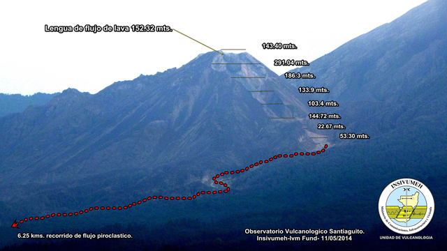 |
Figure 36. Looking approximately N toward Santa María's Santiaguito cone, this photo has been annotated to show surveyed distance measurements (in meters, here "mts.") measured along the slope between the summit and base of Santiaguito as well as the main pathway along the Nimá I drainage. The pyroclastic flow from 9 May 2014 traveled more than 6 km from the active dome (red dotted line). The length of the active lava flow on 11 May 2014 was 152 m. Courtesy of Gustavo Chigna, INSIVUMEH, and the International Volcano Monitoring Fund (IVM Fund). |
Lahars. During 2012-2014, lahars began flowing down Santa María's SE drainages during the onset of the rainy season (table 7). INSIVUMEH reported that many of these events were triggered by heavy rainfall and were frequently contained within the Nimá I drainage (figure 37). Lahars following the nearby rivers Nimá II, San Isidro, and Tambor and merged with the larger river, Samalá. These primary drainages are located S and SW of the active dome (see map in figure 28 of BGVN 24:03; note that Río San Isidro is an intermittent stream located between the Tambor and Nimá II rivers), three of which were included in a hazard map prepared by INSIVUMEH in collaboration with Japan International Cooperation Agency (JICA) in 2003 (figure 38). INSIVUMEH and CONRED released public announcements when Río Samalá was threatened by lahars (for example: 21 May 2012, 23 June 2012, and 6 June 2014) that included specific warnings for the Castillo de Armas bridge; the bridge supports the Interamerican Highway where it passes through the town of San Sebastián.
Table 7. During April 2012- June 2014, weak-to-strong flowing lahars were frequently triggered by heavy rainfall, mainly during April-September each year. Courtesy of INSIVUMEH.
| Year | Date | Drainages | Dimensions | Load | Notes | Damage/At risk |
| 2012 | 25 Apr. | Nimá II | na | 1.5 m diameter blocks; branches and tree trunks; sulfur odor | na | na |
| 21 May | Nimá II | na | 0.4 m diameter blocks; branches and tree trunks | moderate flow | threatened the Castillo Armas bridge and the river bend of El Niño | |
| 29 May | Nimá I & San Isidro | na | 1.5 m diameter blocks; branches and tree trunks; sulfur odor | hot material; moderate strength in Río Nimá I and weak in Río San Isidro; seismic station recorded the event | na | |
| 23 Jun. | Nimá I & San Isidro | na | 0.8 m diameter blocks; branches and tree trunks | moderate strength | threatened the Castillo Armas bridge and the river bend of El Niño | |
| 25 Jun. | Nimá I | na | na | weak strength | na | |
| 27 Jun. | Nimá I | 16 m wide; .9 m high | 0.8 m diameter blocks; sulfur odor | hot material; weak strength; seismic station recorded the event | na | |
| 4 Sept. | Nimá I & San Isidro | 30 m wide; 2 m high | 0.5 m diameter blocks; branches and tree trunks; sulfur odor | hot material; moderate strength; seismic station recorded the event | na | |
| 2013 | 1 Jun. | Nimá I | na | na | weak strength | na |
| 4 Jun. | Nimá I | 40 m wide; 2.5 m high | blocks | moderate flow | na | |
| 8 Jun. | Nimá I, Tambor, & Samalá | na | blocks | moderate flow | na | |
| 20 Jun. | Nimá I and Tambor | 30 m wide; 3 m high | 3 m diameter blocks; branches and tree trunks | moderate flow | na | |
| 11 Aug. | San Isidro, Tambor, & Samalá | 30 m wide; 1.5 m high | 1.5 m in diameter blocks; sulfur odor; branches and tree trunks and plants | hot material | vibrations were felt as the flow passed observers | |
| 31 Aug. | Nimá I | na | 2 m diameter blocks; branches and tree trunks | moderate flow | vibrations were felt as the flow passed observers; river banks were weakened after the flow and small avalanches occurred | |
| 5 Sept. | Nimá I | na | 1-2 m diameter blocks | na | river banks were weakened after the flow and small avalanches occurred | |
| 10 Sept. | Nimá I | 15 m wide; 6 m high | 3 m diameter blocks; sulfur odor | hot material; moderate flow | na | |
| 7 Oct. | Nimá I | 10 m wide; 1 m high | na | weak flow | na | |
| 2014 | 14 May | Nimá I | na | 2 m diameter blocks; branches and tree trunks | na | na |
| 18 May | Nimá I, San Isidro, & Tambor | 15 m wide; 2 m high | 1.5 m in diameter blocks; sulfur odor; branches of tree trunks and plants | hot material; moderate flow | vibrations were felt as the flow passed observers | |
| 22 May | Nimá I | 15 m wide; 2 m high | 1 m diameter blocks; sulfur odor; branches and tree trunks | hot material; moderate flow | na | |
| 24 May | Nimá I, San Isidro, & Tambor | 25 m wide; 2 m high | sulfur odor; branches and tree trunks | hot material; moderate flow | vibrations were felt as the flow passed observers | |
| 29 May | Nimá I, San Isidro, Tambor, & Samalá | 25 m wide; 3 m high | 0.5 and 2 m diameter blocks; sulfur odor; branches and tree trunks | hot material; strong flow | vibrations were felt as the flow passed observers | |
| 30 May | Nimá I & San Isidro | na | na | weak and moderate flow | in the afternoon and evening | |
| 1 Jun. | Nimá I, San Isidro, & Samalá | na | sulfur odor | hot material; strong flow | in the afternoon and evening | |
| 2 Jun. | Nimá I & San Isidro | na | na | moderate and strong flow | na | |
| 6 Jun. | Nimá I | 80 m wide; 5 and 9 m high in series | 5 m diameter | strong flow | emergency evacuation of Observatory staff; lost scientific equipment; damage to the Castillo Armas bridge | |
| 7 Jun. | Nimá I | 35 m wide | 1 m diameter blocks; sulfur odor | hot material; strong flow | na | |
| 8 Jun. | Nimá I | na | na | weak and moderate flow | na |
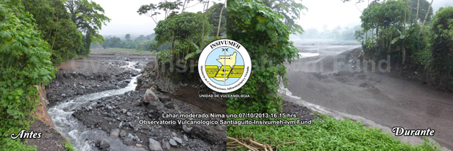 |
Figure 37. This set of two images of the Nimá I drainage shows a small-sized lahar that flowed from Santiaguito cone at 1615 on 7 October 2013 (left image was before (Antes); right image was during (Durante) the lahar flow). Looking upstream, this view is focused on a narrow section of Nimá I that was filled by a 12-m-wide and 1.5-m-high lahar. The rock wall on the right-hand side of the drainage (~3 m high) became a ramp for the lahar and was half-covered by the flow as the gray mass wrapped around the narrow corner in a fast and turbulent flow. Courtesy of Gustavo Chigna, INSIVUMEH and the IVM Fund. |
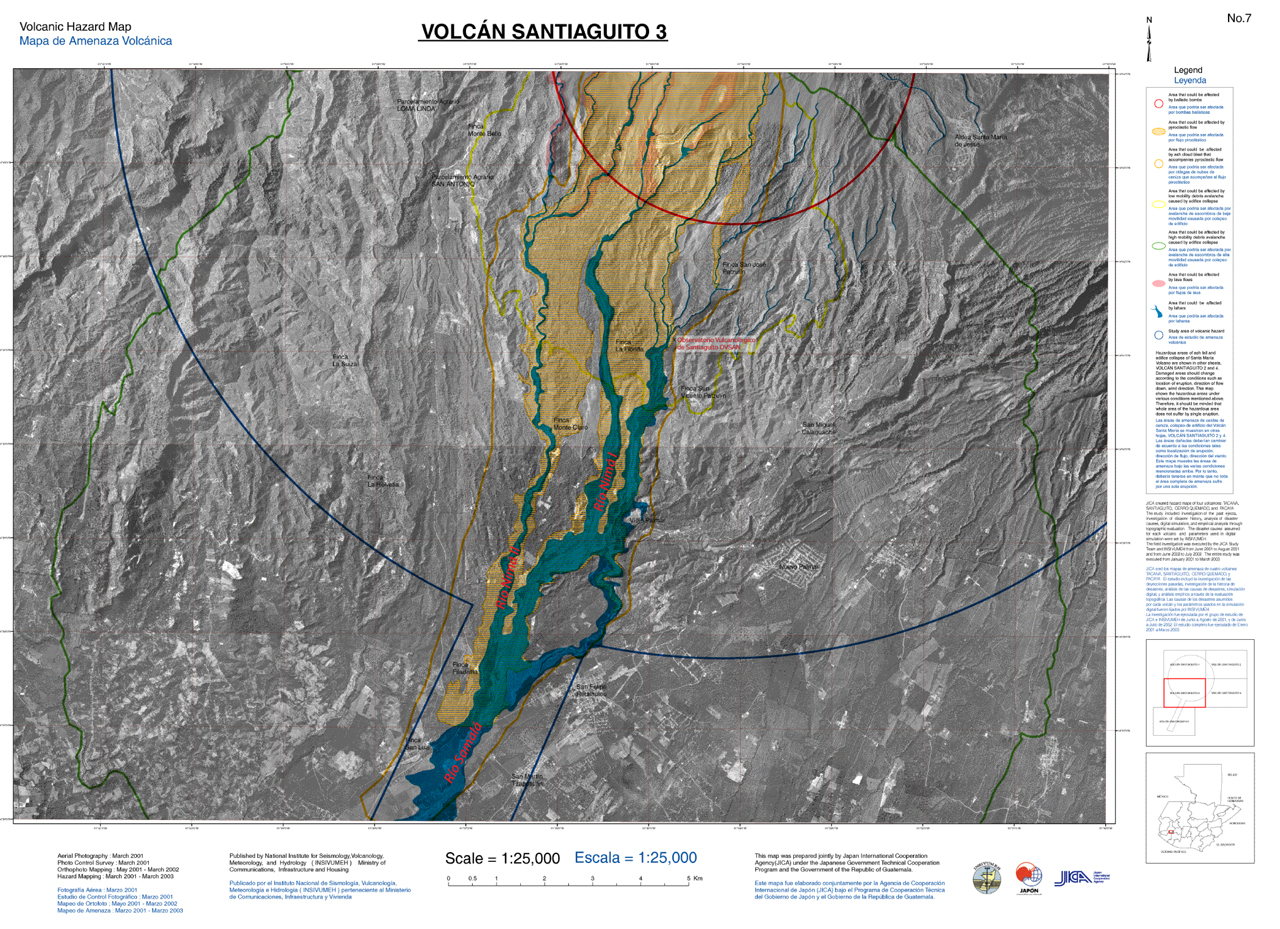 |
Figure 38. Volcanic hazard map (#3 of 5 published in a series) for Santa María focused on the region S of Santiaguito dome. The basemap is from 2001-2002 aerial survey photos and the hazard assessments conducted during 2001-2003 in collaboration with the Japan International Cooperation Agency (JICA). The three drainages (Río Nimá I, Río Nimá II, and Río Samalá labeled in red text) were added by GVP staff. Major towns, farms, and the INSIVUMEH observatory (OVSAN) are labeled; hazard zones are indicated with color coding; the blue semicircle and linear corridor indicates the extent of the study area; the area encompassed by the red semi-circle is at risk for volcanic ballistics. Other hazards include pyroclastic flows (orange shading), lava flows (pink), lahars (blue), ashfall (orange outline), and debris avalanches (yellow and green outlines). Courtesy of INSIVUMEH. |
The most damaging lahar during this reporting period occurred on 6 June 2014. The lahar flowed in pulses down the Nimá I drainage with crests 5-9 m high reaching a maximum width of 80 m. The Santiaguito Observatory (OVSAN) was forced to evacuate when the lahar overflowed the banks and spread across the facility grounds; important scientific equipment was damaged and also washed away. The lahar also flowed into a nearby farm.
Reference. Ball, J.L., Calder, E.S., Hubbard, B.E., and Bernstein, M.L., 2013, An assessment of hydrothermal alteration in the Santiaguito lava dome complex, Guatemala: implications for dome collapse hazards, Bulletin of Volcanology, 75:676.
Information Contacts: Instituto Nacional de Sismologia, Vulcanologia, Meteorologia e Hydrologia (INSIVUMEH), Unit of Volcanology, Geologic Department of Investigation and Services, 7a Av. 14-57, Zona 13, Guatemala City, Guatemala (URL: http://www.insivumeh.gob.gt/inicio.html); Coordinadora Nacional para la Reducción de Desastres (CONRED), Av. Hincapié; 21-72, Zona 13, Guatemala City, Guatemala (URL: http://www.conred.org/); and Washington Volcanic Ash Advisory Center (VAAC), Satellite Analysis Branch (SAB), NOAA/NESDIS E/SP23, NOAA Science Center Room 401, 5200 Auth Rd, Camp Springs, MD 20748, USA (URL: http://www.ospo.noaa.gov/Products/atmosphere/vaac/).
New lava flow descends east flank of dome during June-December 2014; major lahar
The dacitic Santiaguito lava-dome complex on the western flank of Santa Maria volcano has been growing since 1922. The youngest of the four domes in the complex, Caliente, has been actively erupting with ash explosions, lava flows, lahars, and pyroclastic eruptions for more than 40 years (figure 39). A substantial explosion on 9 May 2014 resulted in a 7-km-long pyroclastic flow and ashfall up to 20 km away (BGVN 39:03). This was followed in the next few weeks by a series of lahars in drainages on the south and east flanks of the dome that carried blocks as big as a meter in size. During late May and early June, repeated gas and ash plumes from smaller explosions continued to rise up to 700 m, and caused ashfall 10-15 km S and W. The rest of this report covers the time period June-December 2014 using information, unless otherwise noted, from the Instituto Nacional de Sismologia, Vulcanologia, Meteorologia e Hydrologia (INSIVUMEH).
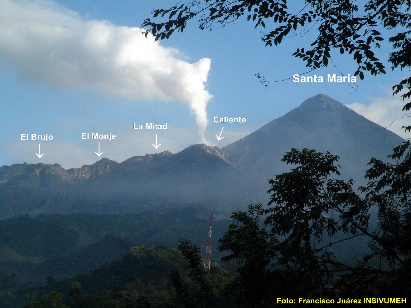 |
Figure 39. Santa Maria volcano and the Santiaguito dome complex. Photo by Francisco Juarez INSIVUMEH. |
The significant events at Santiaguito during the first half of 2014 included the slow growth of a lava flow from the east side of the Caliente vent that began during the 9 May explosion, and a major lahar in early June that did significant damage to equipment at the Santiaguito Observatory (OBSAN). Numerous smaller lahars, ash plumes, block avalanches from the lava flow, and minor ash fall in nearby villages were regular events. Other than degassing reported at Domo del Brujo on 9-10 June, all other events were related to activity from the Caliente vent.
Shortly after the 9 May 2014 eruption, a lava flow was observed slowly descending the E flank of the dome toward the Nimá 1 river drainage. By 11 May it was 152 m long (BGVN 39:03). As the slow-moving lava flow descended the E flank it generated hot block avalanches that sent debris into the Nimá 1 and San Isidro drainages. Incandescence from the flow was often visible at night. By the end of July the flow was 2.1 km long. In early August it moved into the Nimá 1 drainage. The avalanches at the flow front generated columns of fine ash that rose 100-200 m above the flow and drifted E. By mid-September the lava flow had traveled nearly 3.5 km from the summit, was 600 m wide, and was sending avalanche material down the Cabello de Ángel river drainage. By October the flow had slowed its advance, and phreatic explosions were observed from the middle and lower parts of the flow. In late October the more active part of the flow advanced farther southward down the Nimá 1 drainage, while a second flow advanced 3 km E toward the San Jose plantation. The flow continued with slow movement on both lobes for the rest of 2014, generating block avalanches, ash columns, and lahars in the drainages in front of the flow. The thermal signature from the flow was visible in MODIS satellite data (MODVOLC) from June through December.
On 6 June INSIVUMEH reported that the Santiaguito Observatory (OBSAN) was seriously affected by a large lahar that descended the Nimá I river drainage on the S flank of the Santiaguito lava-dome complex. The lahar came in waves, 5-9 m high, was 80 m wide, and carried blocks up to 5 m in diameter. It overtopped the river banks and flowed into a nearby farm. The staff working at OBSAN had to evacuate and some important scientific equipment was lost and damaged. The smaller lahars that regularly occurred during heavy rains throughout the second half of 2014 were generally 18-20 m wide and up to 2 m deep, carrying blocks up to a meter in diameter, tree trunks, and branches. They were most common in the Nimá 1 River drainage and its tributaries the Samala and the Cabello de Ángel, but also occurred on the Tambor River drainage and its tributary the San Isidro. The lahar on 15 July was large enough for INSIVUMEH to issue a warning that included the Castillo Armas bridge on the international highway NE of San Sebastián which crosses the Nimá 1 River 20 km SW of the volcano.
The Caliente vent generated ash plumes up to 500 m that generally drifted SW, with regular ash dispersion up to 1 km from the summit nearly every day during this period. Several times every month except for October, larger ash plumes also rose to 3.2 km (10,500 feet) usually accompanied by small explosions. Ash from these events generally drifted SW or S and deposited ash at Monte Claro farm and as far as Palajunoj, 19 km SW of the summit. Fumarolic activity and degassing with plumes rising to 3 km (10,000 feet) were reported virtually every week throughout the period.
Information Contacts: Instituto Nacional de Sismologia, Vulcanologia, Meteorologia e Hydrologia (INSIVUMEH), Unit of Volcanology, Geologic Department of Investigation and Services, 7a Av. 14-57, Zona 13, Guatemala City, Guatemala (URL: http://www.insivumeh.gob.gt/inicio.html); Hawai''i Institute of Geophysics and Planetology (HIGP), MODVOLC Thermal Alerts System, School of Ocean and Earth Science and Technology (SOEST), Univ. of Hawai''i, 2525 Correa Road, Honolulu, HI 96822, USA (URL: http://modis.higp.hawaii.edu/)
At least 50 ash explosions during January-June 2015, May 2014 lava flow slows down
The Caliente lava dome at the Santiaguito dome complex continued actively erupting during the first half of 2015. There were at least 50 reports of ash explosions during January-June 2015 from Guatemala's INSIVUMEH (Instituto Nacional de Sismologia, Vulcanologia, Meterologia e Hidrologia) or the Washington VAAC (Volcanic Ash Advisory Center). There were also numerous avalanches, several reports of incandescence and audible degassing from the crater and the lava flow, and continued growth of the dacitic lava flow that first erupted in May 2014.
Explosions, ash plumes, and ashfall. Three times in January 2015 INSIVUMEH reported explosions generating ash plumes that rose from 500 to 700 m above the dome. Plumes drifted SW, and minor ashfall was reported each time in Palajunoj (20 km SSW) and once in the village of San Marcos (11 km SW). Washington VAAC reported three additional ash plumes. Each was observed by satellite, rose to an altitude of 4,300 m, (1,800 m above the dome) and drifted 18- 24 km SW or SE.
In February, Washington VAAC reported one ash plume at 4,300 m (1,800 m above the dome) drifting SE, and INSIVUMEH reported five additional days with explosions sending ash-bearing plumes to heights of 200- 800 m above the dome. Ashfall was reported 5 km E; 9-19 km SW in Loma Linda (9 km), San Marcos (11 km) and Palajunoj (twice); approximately 6 km SSE at the Santiaguito Observatory and at the Patzulin farm; and 5 km SE to the village of Santa Maria de Jesus. Generally constant emissions of white steam rose 300 m above the cone and smaller explosions that did not generate ash plumes were also frequently reported.
For March and April, ash-bearing plumes were reported at least 11 times. Two Washington VAAC reports had plumes drifting W at 4,900 m and 4,600 m altitude (2,400 m and 2,100 m above the dome) as far as 18 km from the dome, and one drifting W at 3,400 m altitude (900 m above the dome). INISVUMEH reported plumes rising to between 300 and 800 m above the dome, and producing minor ashfall 20 km SSW in the Palajunoj area seven times; once as far SSW as Retalhuleu (27 km); and SE about 5 km to San Jose Maria farm.
Explosive activity at Caliente increased in May with 13 days of ash-bearing explosions, and many small explosions within the crater and avalanches around the crater rim. INSIVUMEH reported all ash plumes rising to either 500 or 600 m, and drifting from SE to SW, generally up to 20 km. Ashfall was reported in the villages of Calaguache 10 km S, Santa Maria de Jesus 5 km SE, and Palajunoj, and their surrounding farms. The ash plumes reported by Washington VAAC extended 24 km SE, 18 km SSE, 20 km SSW, 16 km SW, and 24 km WNW at altitudes that were 4,300 to 4,600 m (1,800 to 2,100 m above the dome).
Strong, audible degassing from the crater was reported several times during June by INSIVUMEH. They noted explosions with ash-bearing plumes seven times; the plumes rose to between 300 and 800 m above the summit of Caliente, and ashfall was reported six times in the area of Palajunoj, and once in Quetzaltenango 10 km to the N. Washington VAAC reported three additional ash plumes rising to 4,600 m altitude (2,100 m above the dome) and drifting up to 55 km W and WNW.
Dacitic lava flow. The lava flow that began during the 9 May 2014 eruption had traveled more than 3.5 km from the summit and was still incandescent at the front of the flow into early February 2015. Weak to moderate avalanches from the flow were observed through February, after which reported activity tapered off. MODIS/MODVOLC (Moderate Resolution Imaging Spectroradiometer) thermal imaging data also support the observations of a decrease in activity and cooling of the lava flow by March 2015. Thirteen pixels of thermal anomalies were recorded over the volcano in January, with only three in February, two in March, and one in April. On 5 May 2015, INSIVUMEH noted avalanches generated from a possible new flow emerging from the top of the cone, but no MODIS/MODVOLC anomalies were recorded for May.
Information Contacts: Instituto Nacional de Sismologia, Vulcanologia, Meteorologia e Hydrologia (INSIVUMEH), Unit of Volcanology, Geologic Department of Investigation and Services, 7a Av. 14-57, Zona 13, Guatemala City, Guatemala (URL: http://www.insivumeh.gob.gt/inicio.html); Hawai'i Institute of Geophysics and Planetology (HIGP), MODVOLC Thermal Alerts System, School of Ocean and Earth Science and Technology (SOEST), Univ. of Hawai'i, 2525 Correa Road, Honolulu, HI 96822, USA (URL: http://modis.higp.hawaii.edu/); Washington Volcanic Ash Advisory Center (VAAC), Satellite Analysis Branch (SAB), NOAA/NESDIS E/SP23, NOAA Science Center Room 401, 5200 Auth Rd, Camp Springs, MD 20746, USA (URL: http://www.ospo.noaa.gov/Products/atmosphere/vaac/).
Ash plumes drift 300 km W; lava flows continue down Caliente dome
Since 1922, Guatemala's Santa Maria stratovolcano, located 18 km S of the city of Quetzaltenango, has been erupting. Continuous minor explosions, along with periodic lava extrusion, larger explosions, pyroclastic flows, and lahars, have characterized the activity for many years. Guatemala's INSIVUMEH (Instituto Nacional de Sismologia, Vulcanologia, Meterologia e Hidrologia) and the Washington VAAC (Volcanic Ash Advisory Center) provide regular updates on its activity.
The Santiaguito dome complex exhibited constant eruptive activity during July-December 2015. Numerous explosions were reported by INSIVUMEH and the Washington VAAC, with ash plumes rising as high as 7,000 m and drifting as far as 300 km; active lava flows continued down the east side of Caliente dome. In addition, several pyroclastic flows and lahars affected the area around the volcano. Near-constant minor ashfall affected communities within 20 km of the volcano.
Ash plumes, explosions and pyroclastic flows. The Palajunoj area, approximately 10-20 km SW of the Santiaguito dome complex, experienced ashfall events from the Caliente lava dome multiple times per week between July and December 2015. The farms, or 'fincas' of Palajunoj including El Monte Claro, Rosario, La Florida, and El Faro, and the village of San Marcos, were the most frequently affected by explosions. Typical ash plumes rose 500 to 800 m above the Caliente dome (to 3,000-3,300 m altitude) and deposited fine ash downwind, generally to the W and SW, up to 20 km.
Nearly every month during this time, one or more larger explosions were recorded to heights of 1,800 to 2,400 m above Caliente (4,300-4,900 m altitude). The volcanic ash from these emissions, as reported by the Washington VAAC, generally drifted tens of kilometers W and SW. Occasional larger explosive events affected an even wider area. On 24 August the Washington VAAC observed in satellite imagery the remnants of a plume that rose to 5,200 m (2,700 m above the dome) and drifted 300 km WSW.
On 29 August INSIVUMEH reported multiple loud explosions occurring four to six hours apart that included thick columns of ash and pyroclastic flows. Based on Observatorio del Volcán Santiaguito (OVSAN) observations, INSIVUMEH noted that on 29 September explosions from the lava-dome complex again generated multiple small pyroclastic flows. The largest of these traveled 4 km E down the Ángel and Nimá I drainages. Dense ash plumes drifted generally E, and caused ashfall in areas between Quetzaltenango (18 km WNW) and El Palmar (12 km S).
Large explosions reported by the Washington VAAC on 7 October and 30 November sent ash plumes to the SW at altitudes of 5,800 and 6,000 m, respectively. The largest group of explosions during this period, however, occurred in early December. Loud explosions and moderate pyroclastic flows on 1 December were noted by INSIVUMEH, and ashfall was reported to the WSW in San Marcos, La Florida and across the Palajunoj area. Washington VAAC observed the ash plume from these explosions at least as high as 7,000 m drifting SW for over 24 hours. Its farthest observed distance from the volcano was around 280 km WSW before dissipating on 2 December. Another series of large explosions with continued emissions took place on 5-6 December. INSIVUMEH reported fine ashfall at least 10 km from the dome in multiple directions, SW, S, SE, and E. Satellite images observed by the Washington VAAC showed an ash plume at 5,800 m altitude over 300 km to the W over the Gulf of Tehuantepec from these events. Another residual ash cloud at 5,200 m altitude was observed on 29 December 150 km SW from explosions that occurred on 28 December.
Lava flow. The lava flow that traveled down the E flank of the Caliente dome beginning in May 2014 and early 2015 (figure 40) continued to be active for the second half of 2015, but the activity was concentrated at the head of the flow near the dome. Block avalanches at the front of the new flows were reported every week. Additional lava was reported extruding from the Caliente dome on 1 September. Active lava flows with steam plumes 200-300 m high coming from the base of the dome were reported by INSIVUMEH on 19 September and again on 4 October. Incandescent avalanche blocks were observed often in November and December along the entire length of the E flank of the dome, suggesting that the upper part of the lava flow remained active. On 8 December, continuous lava flows down the outer SE edge of the dome from the crater to the base generated avalanche blocks and hot pyroclastic flows. Intermittent MODVOLC thermal alerts were also recorded during this time.
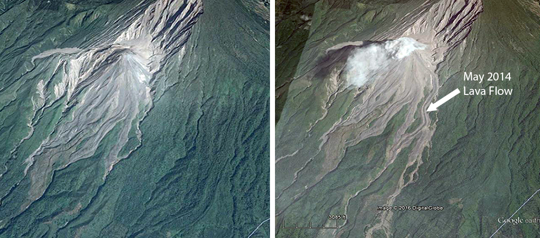 |
Figure 40. Google Earth images at different times show the growth of the lava flow that first emerged from Caliente dome in May 2014 at Santa Maria. The left image is dated April 2014 and the right image is dated March 2015. The new lava flow is visible travelling in a zig-zag pattern down the drainage to the SSW in the center of the image. It splits about half way down into two flows. North is to the top. Additional descriptions of the flow are given in BGVN 40:07. |
Lahars. On 8 September heavy rainfall triggered a hot lahar that descended the Nimá I river drainage on the S flank. The lahar carried tree trunks, branches, and 1-m-wide blocks, had a strong sulfur odor, and was 20 m wide and 1.5 m deep. Another smaller lahar descended the Nimá I river drainage on 11 September. INSIVUMEH reported that on 21 October heavy rainfall in the area triggered steaming hot lahars which again descended Nimá I and also the San Isidro drainage. Both lahars carried blocks as large as 1.5 m in diameter; the Nimá I deposit was 18 m wide and 1.5 m deep. Another heavy rainfall on 30 October area triggered cold lahars which descended the Cabello de Ángel (a tributary of Nimá I) and San Isidro (tributary of El Tambor) drainages. The lahar in San Isidro carried blocks that were 1-2 m in diameter.
Information Contacts: Instituto Nacional de Sismologia, Vulcanologia, Meteorologia e Hydrologia (INSIVUMEH), Unit of Volcanology, Geologic Department of Investigation and Services, 7a Av. 14-57, Zona 13, Guatemala City, Guatemala (URL: http://www.insivumeh.gob.gt/inicio.html); Hawai'i Institute of Geophysics and Planetology (HIGP), MODVOLC Thermal Alerts System, School of Ocean and Earth Science and Technology (SOEST), Univ. of Hawai'i, 2525 Correa Road, Honolulu, HI 96822, USA (URL: http://modis.higp.hawaii.edu/); Washington Volcanic Ash Advisory Center (VAAC), Satellite Analysis Branch (SAB), NOAA/NESDIS E/SP23, NOAA Science Center Room 401, 5200 Auth Rd, Camp Springs, MD 20746, USA (URL: http://www.ospo.noaa.gov/Products/atmosphere/vaac/); Google Earth (URL: https://earth.google.com/).
Increased explosive activity, numerous pyroclastic flows from January through June 2016
The dacitic Santiaguito lava-dome complex on the W flank of Guatemala's Santa Maria volcano has been growing since 1922. The youngest of the four vents in the complex, Caliente, has been actively erupting with ash explosions, pyroclastic flows, and lava flows for more than 40 years. This activity continued throughout 2015, with ash plumes rising up to 7 km altitude and drifting as far as 300 km from the volcano. The summit of the Caliente vent is about 2.5 km, and the summit of the volcano is about 3.7 km elevation. Communities within 20 km (mostly W, SW, and S) experienced near-constant minor ashfall, and active lava flows continued to migrate down the E side of Caliente. Pyroclastic flows and lahars also affected several areas in 2015. Guatemala's INSIVUMEH (Instituto Nacional de Sismologia, Vulcanologia, Meterologia e Hidrologia) and the Washington VAAC (Volcanic Ash Advisory Center) provided regular updates on the continuing activity during the first half of 2016 and are the sources for this report.
From January to June 2016, Caliente constantly emitted steam and bluish magmatic gases which rose 300-400 m above the crater. Major explosions with ash occurred in early February, April, May, and June 2016. The largest events of the last two years in terms of both frequency and size were recorded in April and May 2016. Ash plumes rose to 5 km altitude every month except March, and wind dispersed ash clouds as far as 500 km from the volcano; ashfall was reported regularly (several days every week) in villages within 20 km, and occasionally as far away as 60 km. Explosions sent several-meter-size bombs up to 3 km from the volcano. Pyroclastic flows descended drainages on several sides of Caliente, and contributed to collapses of the crater walls at the top of the cone. Lahars comprised of hot, SO2-rich ash and mud, and meter-size blocks traveled down the main drainages during May and June. MODIS infrared satellite data reported by both MODVOLC and MIROVA supported the physical evidence for heightened activity during this time.
Explosions in January 2016 were weak to moderate in size, causing ashfall in communities 10-20 km W and S. They averaged 10-20 per day, some sending one-meter-size blocks 200 m from the cone. On 20 January 2016 a pyroclastic flow from a loud explosion sent an ash cloud to 4.5 km altitude, and descended the S and SW sides of the cone (figure 41). The explosion was heard 10 km to the S. Ash plumes in January generally remained below 5 km altitude and drifted a few tens of kilometers from the summit in multiple directions.
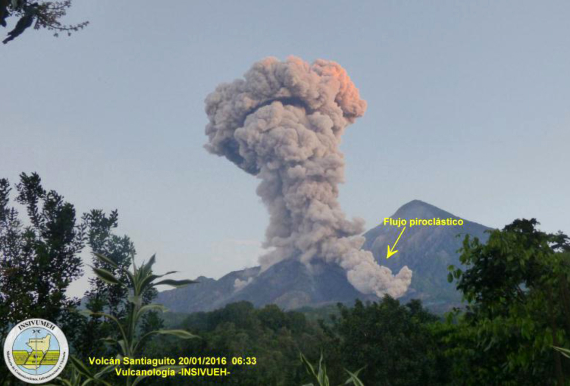 |
Figure 41. Ash explosion and pyroclastic flow at Santa Maria on 20 January 2016. The Washington VAAC reported the plume rising to 5 km altitude. Photo taken from the OVSAM observatory, 6 km SW of the Caliente vent. Courtesy of INSIVUMEH (January 2016 Santiaguito Report). |
Lava flows that began on 9 May 2014 and traveled several kilometers SE down the Nimá 1 and Cabello de Ángel (a tributary of the Nimá 1) drainages had ceased advancing by January 2016; the flows were up to 50 m thick in places and had cooled substantially (figure 42). Small avalanches, however, were reported from active lava flows close to the summit, and could be seen in satellite thermal images.
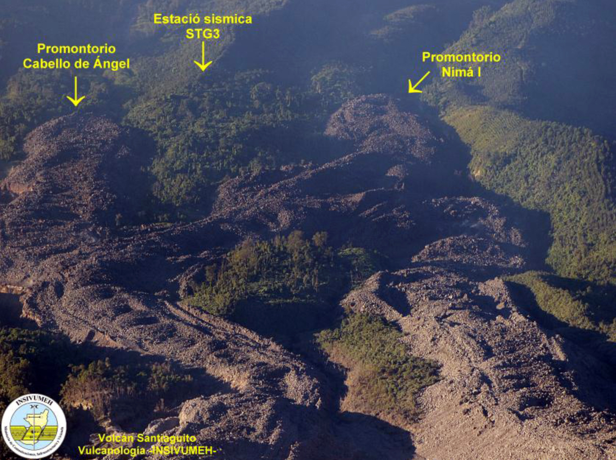 |
Figure 42. Lava flows at the Santiaguito complex of Santa Maria that came down the Nimá 1 and Cabello de Ángel river drainages in 2014 and 2015 had stopped moving by January 2016, leaving 50-m-high walls of lava in the drainages on either side of seismic station STG-3. Image is looking downhill to the south on the SE side of Caliente. The new lava flows are labelled, an older one is visible at the lower right. Compare with Google Earth image in BGVN 41:02 for a full view of the lava flow. Image was published in January 2016, but exact date is not given; it is likely from late 2015. Courtesy of INSIVUMEH (January 2016 Santiaguito Report). |
A large ash cloud reported by the Washington VAAC on 2 February 2016 rose to 6 km altitude and drifted over 500 km NNW before dissipating the next day. Ashfall was reported in the community of San Marcos 10 km SW and on the surrounding farms. A series of strong explosions beginning 7 February were heard up to 25 km away, and generated pyroclastic flows that descended the E and SE flanks; a dense ash cloud rose to 6 km altitude and drifted in several directions. Subsequent explosions in February had ash plume heights between 4 and 5.5 km and drifted a few tens of kilometers from the volcano.
In a special bulletin posted on 8 March, INSIVUMEH stated that a moderate explosion had caused additional collapse of part of Caliente cone, and a pyroclastic flow descended the NNE flank; the collapse also created a dense ash plume that covered the entire volcanic complex, and rose to 4 km altitude and drifted NNE. Activity diminished after this, and ash plumes remained under 5 km altitude, generally drifting less than 20 km from the cone before dissipating for the rest of March. Weak block avalanches continued down the E flank from a slowly advancing lava flow.
Major explosions and pyroclastic flows increased early in April and continued through June 2016. Plumes reported by the Washington VAAC rose to between 6 and 7.5 km altitude six times in April. Plumes emitted on 11 April drifted over 500 km SW before dissipating. Strong explosions on 3, 15, 19, and 23 April caused multiple pyroclastic flows which descended the E, SE, SW, and W flanks. During each of these events, parts of the crater rim collapsed, and mushroom-shaped ash clouds rose to between 4,000 and 5,000 m altitude, dispersing ash over the towns of Loma Linda, San Marcos, Las Marías, Palajunoj, and the neighboring farms, within 20 km SW of Santiaguito. Explosions during 19-22 April also ejected 2-3 m blocks up to 3 km from the cone.
In a special bulletin from 23 April, INSIVUMEH stated that a very high level of activity continued, and was the highest recorded in the previous two years. During the 23 April explosions, ash plumes that rose 4-5 km above the cone (6.5-7.5 km altitude) drifted 60 km W and NW, causing ashfall in the towns of Quetzaltenango (10 km N), Retalhuleu (30 km SW), and Mazatenango (25 km SSE). Abundant ash fell in communities within 20 km S and W of the volcano including San Marcos, Loma Linda, Palajunoj, Las Marías, El Palmar, and San Felipe Retalhuleu, and also the farms of Monte Bello, Monte Claro, El Faro, Patzulin, and La Florida. The pyroclastic flows of 23 April descended 3 km E and W down the Cabello de Ángel and San Isidro drainages.
INSIVUMEH reported a 2 May explosion with a plume that rose to 10 km altitude, significantly higher than most plumes from Santiaguito. It generated two pyroclastic flows which descended the E and W drainages. The Washington VAAC reported ash plumes from this explosion drifting nearly 500 km SW; they reported explosions with ash plumes rising to 6 km or higher 12 times during May. On 22 May, strong explosions generated dense ash plumes that drifted to the WSW and brought ashfall to Colomba (19 km WSW) and Coatepeque, more than 30 km WSW. Many of the communities within 20 km SW of the volcano such as San Felipe Retalhuleu, El Nuevo Palmar, Las Marías, and the farms of Loma Linda, San Marcos, Palajunoj, El Faro, La Florida, Patzulin, and El Patrocinio were also affected by ashfall. Pyroclastic flows traveled 2 km down the E, S, and W flanks and down the Cabello de Ángel and San Isidro drainages during these explosions (figure 43). INSIVUMEH noted that volcanic bombs were again ejected up to 3 km from the cone.
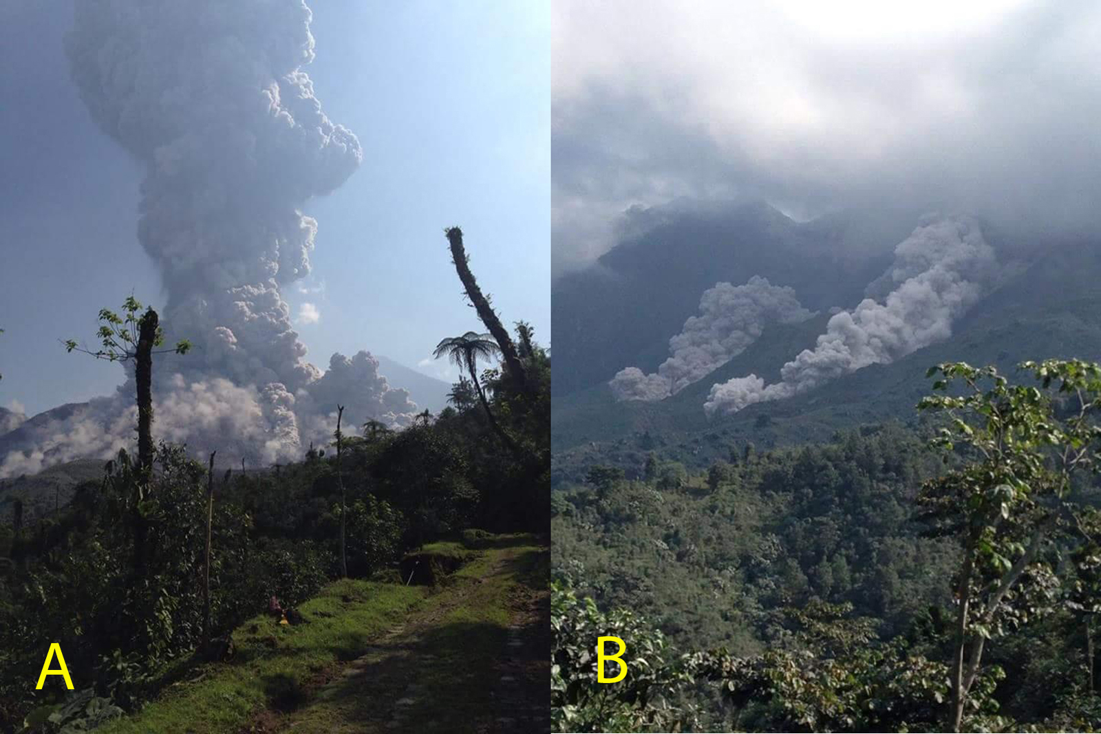 |
Figure 43. Ash explosion (A), and pyroclastic flows (B) which descended the Nimá 1 river drainage on the SE side of Caliente at Santa Maria on 22 May 2016. The Washington VAAC reported this plume at over 6 km altitude. Courtesy of INSIVUMEH (May 2016 Santiaguito report). |
In a special report posted on 25 May, INSIVUMEH noted continued energetic explosive activity at Caliente, with loud explosions and mushroom-shaped ash clouds that rose to 5 km altitude and drifted more than 40 km WSW. Ashfall was again noted in communities to the S and W. Pyroclastic flows traveled 2 km E, S, and W, in the San Isidro and Cabello de Ángel drainages.
The wind directions at Santiaguito are controlled by both the prevailing winds and the fact that the summit of Santa Maria (3.7 km) is over 1,000 m higher than the top of the summit crater at Caliente (2.5 km). Thus, the height of the explosion often determines the dispersion direction of the ash. Plumes that do not rise above the summit of Santa Maria generally disperse to the W or WSW as the prevailing wind is most often from the E, and ashfall is then observed in San Marcos (11 km SW) and surrounding villages and farms. When ash plumes exceed 3.8 km, the plume directions are much more variable. If the wind blows from the south, ashfall commonly reaches Quetzaltenango located 10-15 km to the N, whereas wind from the north will send the plume 30 km or more to the S or SW. It is thus not uncommon with large plumes that rise above 3.8 km to have wind dispersing ash in different directions at different altitudes (figure 44) at the same time. For example on 26 May, the Washington VAAC reported plumes at 5.2 km drifting 15 km SW while those at 6.4 km altitude were observed 70 km S.
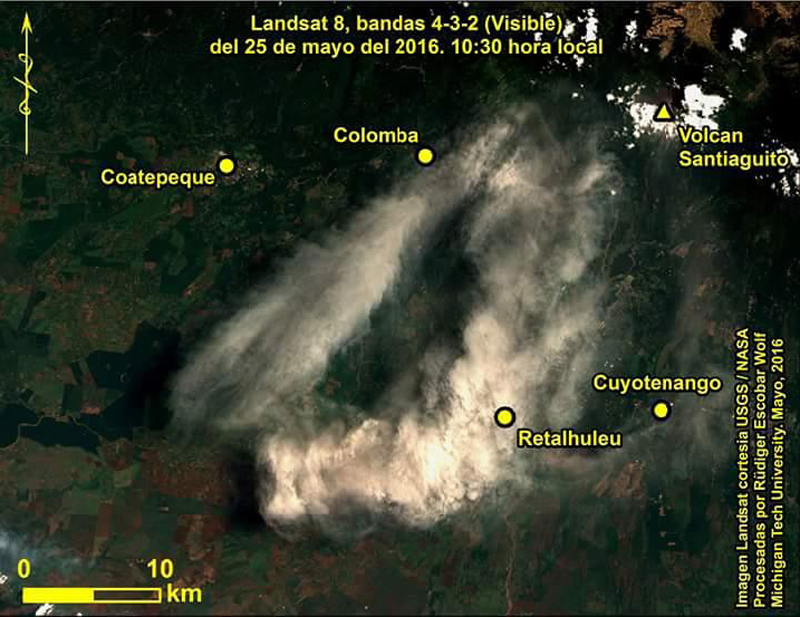 |
Figure 44. Landsat image of the ash cloud from Santa Maria dispersing more than 40 km in two directions, to the S and SW, on 25 May 2016. Courtesy of INSIVUMEH (May 2016 Santiaguito report) and USGS/NASA. |
Five strong explosions were recorded on 1, 17, 19, 20, and 29 June 2016; most were accompanied by pyroclastic flows down the sides of the cone. During the month, ash plumes at 5-6 km altitude were recorded numerous times, including plumes that drifted up to 100 km WSW into Mexican territory. Ashfall was reported in most communities up to 20 km away to the S and W after these events. A loud explosion on 20 June generated an ash plume containing lightning, and shock waves that were detected in areas within 15 km. A CONRED (Coordinadora Nacional para la Reducción de Desastres) report from 29 June noted that more than 60 moderate-to-large explosions had been detected through the end of June 2016, marking a very active period. The large volcanic bombs from these explosions traveled up to 3 km from the cone (figure 45).
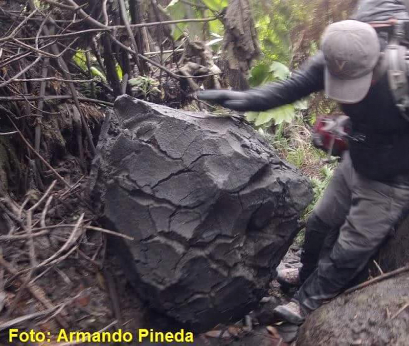 |
Figure 45. Bread-crust bomb about one meter in diameter located a few kilometers from the Caliente vent at Santa Maria on the tourist route, discovered in June 2016. Photo by Armando Pineda, courtesy of INSIVUMEH (June 2016 Santiaguito Report). |
Two lahars came down the rivers in May, and five moderate-to-large lahars were recorded in June. On 13 June the 30-m-wide lahar that went down the Nimá 1 drainage was hot and had a strong sulfur odor, and carried tree trunks, branches, and rocks 2-3 m in diameter (figure 46).
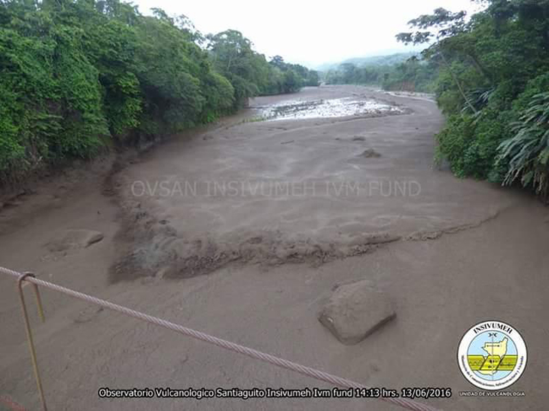 |
Figure 46. A powerful lahar descended the Nimá I river drainage at Santa Maria on 13 June 2016 with waves of hot, sulfur-smelling mud, and trees, branches, and blocks up to 3 m in diameter. Courtesy of INSIVUMEH and OVSAN (June 2016 Santiaguito Report). |
The MODVOLC thermal alert system mapped 20 pixels of anomalies from the MODIS infrared satellite data between January and June 2016. Three were in January, five in February (three on 27 February), seven were in April, (with five of those recorded on 20 April during a period of many large explosions reported by INSIVUMEH); five more were recorded in May. Heat emitted from flows around the cone and large, hot ash plumes and pyroclastic eruptions were the likely sources for the anomalies. The plot of the log Radiative Power at Santa Maria from the MIROVA system's analysis of the MODIS data agrees with the increase in activity reported during the first six months of 2016 by INSIVUMEH and the Washington VAAC (figure 47). MIROVA data indicate a period of increased radiative power that intensified in November 2015, and carried through to June 2016 before tapering off later in the year.
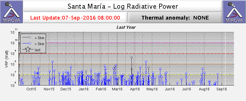 |
Figure 47. Increased VRP (Volcanic Radiative Power) at Santa Maria is evident in the MIROVA system coverage of the MODIS infrared satellite data from 7 September 2015 to 7 September 2016. Measurements of VRP between 107 and 108 watts were frequent between November 2015 and June 2016. Courtesy of MIROVA. |
Information Contacts: Instituto Nacional de Sismologia, Vulcanologia, Meteorologia e Hydrologia (INSIVUMEH), Unit of Volcanology, Geologic Department of Investigation and Services, 7a Av. 14-57, Zona 13, Guatemala City, Guatemala (URL: http://www.insivumeh.gob.gt/); Washington Volcanic Ash Advisory Center (VAAC), Satellite Analysis Branch (SAB), NOAA/NESDIS OSPO, NOAA Science Center Room 401, 5200 Auth Rd, Camp Springs, MD 20746, USA (URL: http://www.ospo.noaa.gov/Products/atmosphere/vaac/) [Archive at http://www.ssd.noaa.gov/VAAC/archive.html]; Coordinadora Nacional para la Reducción de Desastres (CONRED), Av. Hincapié 21-72, Zona 13, Guatemala City, Guatemala (URL: http://conred.gob.gt/www/index.php?option=com_content&view=featured&Itemid=102); Hawai'i Institute of Geophysics and Planetology (HIGP), MODVOLC Thermal Alerts System, School of Ocean and Earth Science and Technology (SOEST), Univ. of Hawai'i, 2525 Correa Road, Honolulu, HI 96822, USA (URL: http://modis.higp.hawaii.edu/); MIROVA (Middle InfraRed Observation of Volcanic Activity), a collaborative project between the Universities of Turin and Florence (Italy) supported by the Centre for Volcanic Risk of the Italian Civil Protection Department (URL: http://www.mirovaweb.it/); USGS Landsat Data Access (URL: https://landsat.usgs.gov/landsat-data-access).
Continuous ash emissions, pyroclastic flows and lahars; new lava dome visible at Caliente dome, October 2016
The dacitic Santiaguito lava-dome complex on the W flank of Guatemala's Santa María volcano has been growing since 1922. The youngest of the four vents in the complex, Caliente, has been actively erupting with ash explosions, pyroclastic flows, and lava flows for more than 40 years. Constant steam and magmatic gases during January-June 2016 were accompanied by some of the largest explosive events of the last few years in April and May. Ash plumes rose to over 5 km altitude and spread ash regularly over communities within 30 km (BGVN 41:09). Guatemala's INSIVUMEH (Instituto Nacional de Sismologia, Vulcanologia, Meterologia e Hidrologia) and the Washington VAAC (Volcanic Ash Advisory Center) provided regular updates on the continuing activity during the second half of 2016, and are the primary sources of information for this report.
Constant emission of both steam and magmatic gas were observed from the summit of Caliente dome throughout July-December 2016. Overall, eruptive activity decreased during this period compared with the previous six months. During July-September, INSIVUMEH reported 3-5 daily weak or moderate explosions with ash plumes that rose to 3.3-3.5 km altitude and dispersed ash over communities generally to the SW within 30 km. Stronger explosions took place 5-10 times each month from July-September. The ash plumes from these larger explosions usually rose to 5-5.5 km altitude. The highest plume was reported by the Washington VAAC at 6.1 km altitude during August. Ash plumes drifted more than 100 km from the volcano on several occasions, and ashfall was reported more than 50 km away more than once. These larger explosions also produced numerous pyroclastic flows that descended into the drainages on the SE, S, and SW flanks of Caliente dome. Heavy rains resulted in substantial lahars generated from the ash and debris several times each month.
INSIVUMEH observed the growth of a new lava dome inside the summit crater of Caliente beginning in October. By the end of the year, it had filled more than half of the summit crater with new material. During October, November, and the first part of December, the number of smaller explosions to around 3.5 km altitude increased to 25-35 daily events.
Activity during July-August 2016. Eruptive activity at the Santiaguito dome complex decreased from previous months during July 2016. Constant degassing from the Caliente dome, weak and moderate daily explosions, and ashfall in nearby (5-20 km) communities to the W and SW were typical. Steam and magmatic gases generally rose 300-400 m above the summit crater. Three or four weak to moderate explosions per day generally created diffuse ash plumes that rose to altitudes of 3.3-3.5 km. Ashfall from the smaller explosions generally affected the villages of San Marcos Palajunoj, Loma Linda, Monte Bello, and a few others located 10-20 km SW. Four stronger explosions on 1 (2), 3, and 10 July sent ash plumes to altitudes of 5-5.5 km (figure 48) and generated pyroclastic flows that descended the SW, S, and SE flanks (figure 49).
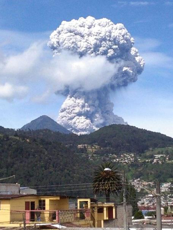 |
Figure 48. A strong explosion with a mushroom-cloud-shaped ash plume rising to 5.5 km on 1 July 2016 at Santa María. View is from the NW. Courtesy of INSIVUMEH (Informe Mensual de Actividad Volcánica, Julio 2016). |
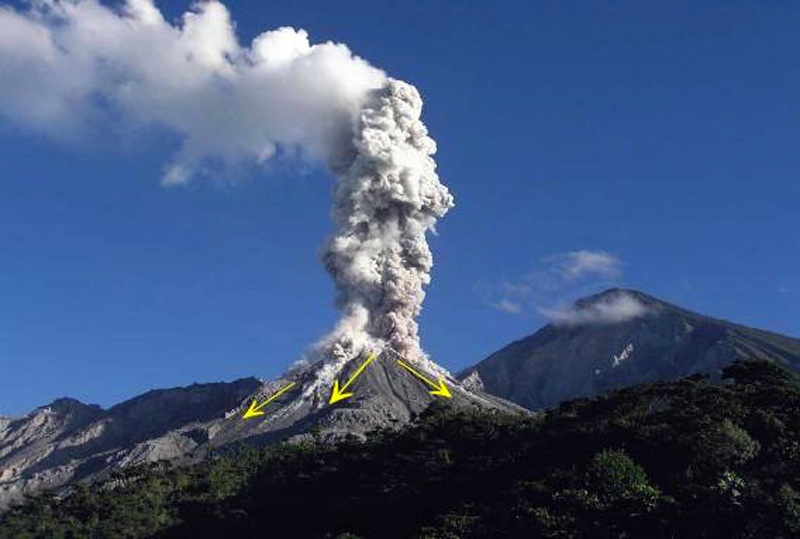 |
Figure 49. A strong explosion with pyroclastic flows traveling down the SW, S, and SE flanks of Caliente dome at Santa María during July 2016. View is from the SE. Courtesy of INSIVUMEH (Informe Mensual de Actividad Volcánica, Julio 2016). |
Ash from the larger explosions was reported at least once in Columba, about 20 km SW (figure 50), Malacatán (about 55 km NW), and also from the Chiapas regions of Mexico, 70 km W. The Washington VAAC reported a plume on 1 July at 5.2 km altitude with ash extending about 35 km WNW. On 10 July, they observed an ash plume in multispectral imagery moving NW about 45 km from the summit. They also observed a bright hotspot at the summit. On 11 July, they reported an ash plume at 6.4 km altitude extending over 80 km NW. Dissipating ash was visible in imagery about 275 km NW later in the day.
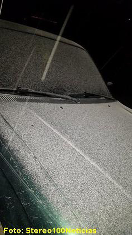 |
Figure 50. Ash fall covered vehicles in Colomba, about 20 km SW, from one of the larger explosions at Santa María during July 2016. Courtesy of INSIVUMEH (Informe Mensual de Actividad Volcánica, Julio 2016). |
A lahar descended the Cabello de Ángel river drainage on 3 July 2016 after a large explosion (figure 51). It was up to 30 m wide in places, and 1.5 m deep with blocks up to 1.5 m in diameter. The Cabello de Ángel flows into the Nimá I and Samala River drainages.
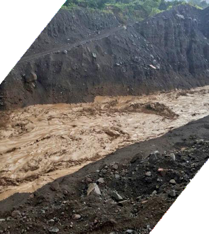 |
Figure 51. A lahar descends the Nimá I drainage on 3 July 2016 at Santa María after a large explosion created a pyroclastic flow down the S flank. Courtesy of INSIVUMEH (Informe Mensual de Actividad Volcánica, Julio 2016). |
Constant degassing of steam and bluish magmatic gases continued during August 2016, rising 100-400 m above the summit of Caliente dome. Three to five weak or moderate explosions occurred daily, sending ash plumes to altitudes of 3.3-3.5 km (800-1,000 m above the dome). The STG3 seismic station recorded nine larger explosions in August (4, 14, 16, 18, 20, 21, 23, 28) that sent ash emissions to 4-5.5 km altitude, and generated pyroclastic flows that descended up to 2.5 km down the flanks (figure 52). The incandescent rock and ash descended the Nimá I, Nimá II, and San Isidro drainages on the SW, S, and SE flanks.
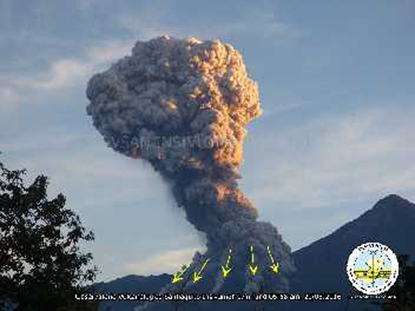 |
Figure 52. Pyroclastic flows descend several drainages on the S, SW, and SE flanks of Caliente at Santa María during one of the large explosions of August 2016. Courtesy of INSIVUMEH (Informe Mensual de Actividad Volcánica, Agosto 2016). |
Communities and fincas (farms) affected by ashfall from these explosions included San Marcos Palajunoj, Loma Linda, Monte Bello, San Felipe (15 km SSW), Mazatenango (25 km SSE), Retalhuleu (27 km SW), El Faro, La Florida (5 km S), Patzulin (SW flank), and El Patrocinio. Tephra particles as large as 8 mm were collected in Loma Linda (figure 53). A few of the explosions resulted in ashfall more than 50 km from the volcano, including into Mexico. The Washington VAAC reported ash plumes rising to 5.8 km on 1 August; they were later visible 175 km W of the Mexico coast, W of Tapachula, Mexico. Two emissions on 12 August were seen at 5.2 km altitude drifting W. Ongoing emissions were reported at 6.1 km altitude on 16 August moving WNW and extending about 80 km. The plume observed on 19 August was 65 km NW at 5.5 km altitude. A plume observed in multispectral imagery on 25 August was moving NW at 6.1 km altitude over 185 km from the summit.
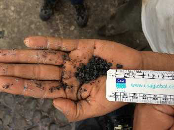 |
Figure 53. Lapilli fragments as large as 8 mm diameter were collected in Loma Linda on 16 August 2016 from an explosion at Santa María. Courtesy of INSIVUMEH (Informe Mensual de Actividad Volcánica, Agosto 2016). |
Increased precipitation during August 2016 led to lahars on 8, 13, and 29 August 2016 that descended the Cabello de Ángel , Nimá I, and Samalá drainages. They ranged from 18 to 25 m wide and were 1.5 m deep containing blocks up to 1.5 m in diameter. Flooding was reported downstream near the Castillo Armas bridge on the Samalá River.
Activity during September 2016. Most of the steam and magmatic gases emitting daily from Caliente during September 2016 rose 100-400 m above the dome and generally drifted SW or W (figure 54). Small to moderate ash-bearing explosions occurred 3-5 times daily; ash plumes generally rose to 3.3-3.5 km altitude during these events. Several stronger explosions during September (1, 4, 11, 17, 19, 24, 25, 30) generated ash plumes that rose to 4.5 or 5 km altitude and drifted W, SW, S, SE and E. The Washington VAAC also reported an ash plume observed in multispectral imagery on 20 September at 5.2 km altitude drifting 45 km W. A few hours later, they reported two plumes, one at 4.6 km drifting 75 mi W, and a second at 5.2 km altitude moving WSW over 80 km from the summit.
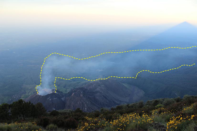 |
Figure 54. A magmatic gas plume drifts W from the Caliente dome in this view from the summit of Santa María during September 2016. Courtesy of INSIVUMEH (Informe Mensual de Actividad Volcánica, Septiembre 2016). |
Near-daily ashfall was reported from many of the communities 10-20 km SW including San Marcos Palajunoj, Loma Linda, Monte Bello, Santa María de Jesús, El Nuevo Palmar, and Las Marías (figure 55) during September 2016. Lapilli as large as 15 mm diameter was collected in the neighborhoods of San Marcos Palajunoj (figure 56).
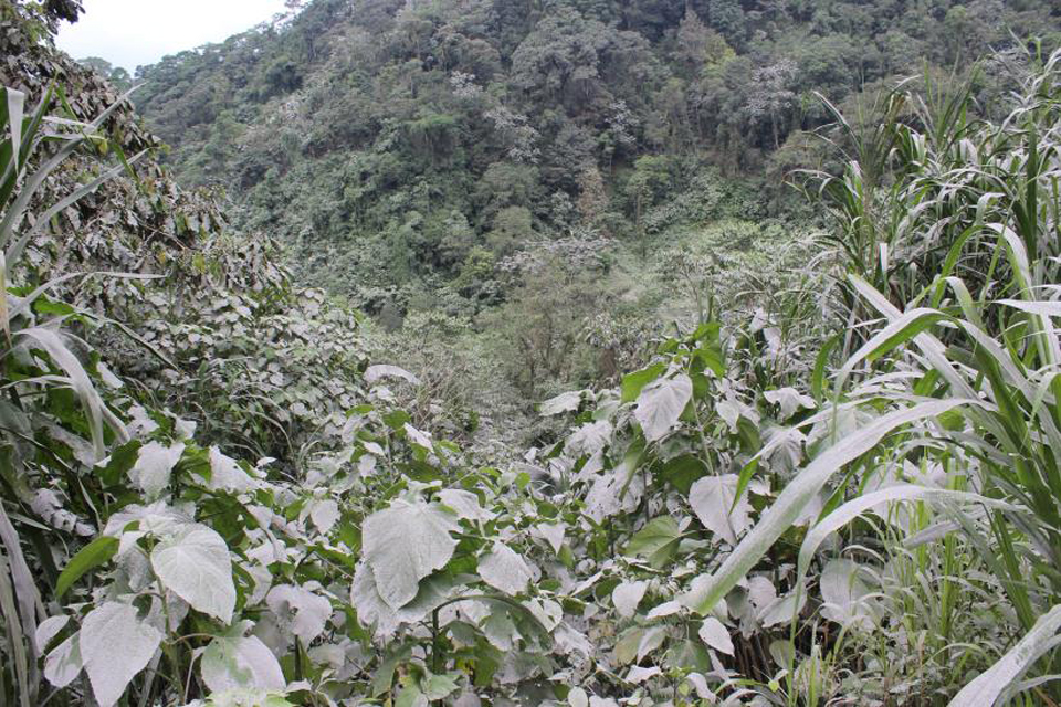 |
Figure 55. Vegetation near Loma Linda was covered with ash almost daily from Santa María during September 2016. Courtesy of INSIVUMEH (Informe Mensual de Actividad Volcánica, Septiembre 2016). |
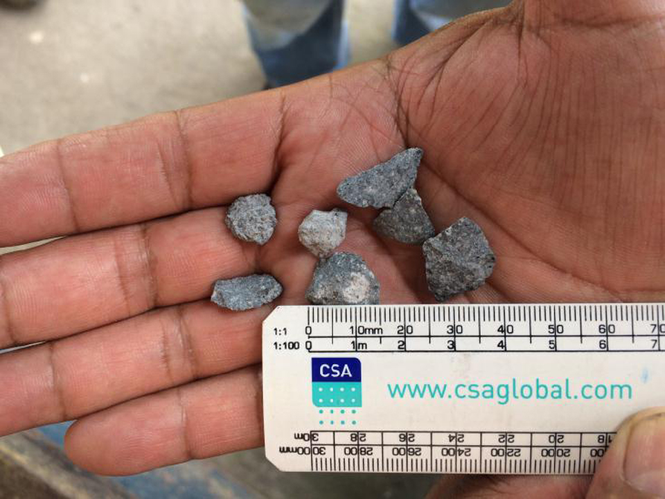 |
Figure 56. Lapilli from Santa María up to 15 mm in diameter fell in the village San Marcos Palajunoj during September 2016. Courtesy of INSIVUMEH (Informe Mensual de Actividad Volcánica, Septiembre 2016). |
The larger explosions also resulted in pyroclastic flows that travelled 2.0-2.5 km down the SW, S, and SE flanks in the Nimá I, Nimá II, and San Isidro drainages. Areas of vegetation burned from the heat of the pyroclastic flows (figure 57).
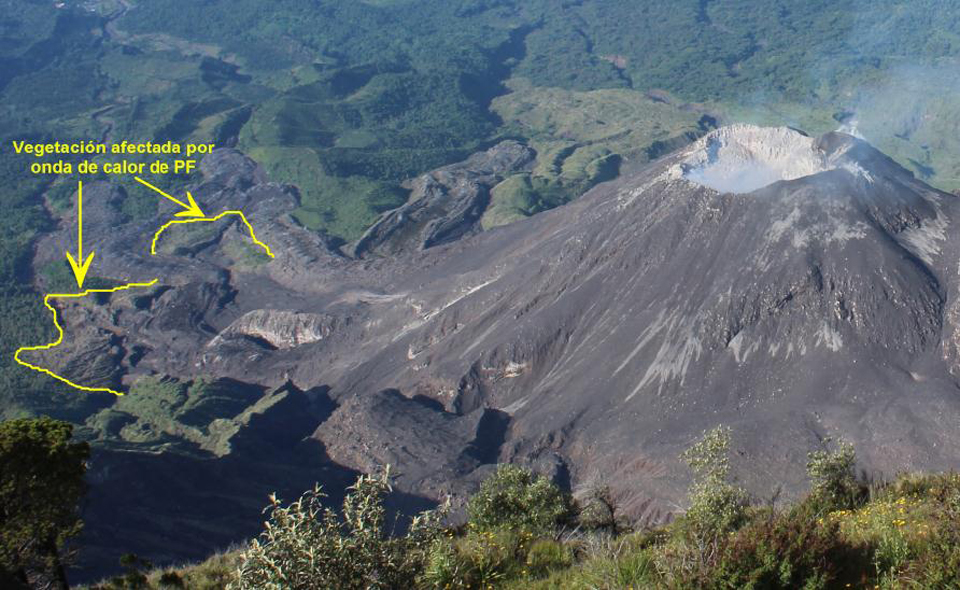 |
Figure 57. Several areas of burned vegetation from the pyroclastic flows that descended the drainages on the SE flank of Caliente dome at Santa María during September 2016 are highlighted in yellow. The view is from the summit of Santa María looking S. Courtesy of INSIVUMEH (Informe Mensual de Actividad Volcánica, Septiembre 2016). |
Lahars or heavy mudflows were recorded on ten days during September, primarily in the Cabello de Ángel and Nimá I drainages (figure 58). Channels of debris worked their way over the 2015 lava flows in the Nimá I drainage and continued downstream. The lahars were 13-20 m wide and 1.5 m high and carried clay, volcanic ash, and blocks up to 1.5 m in diameter.
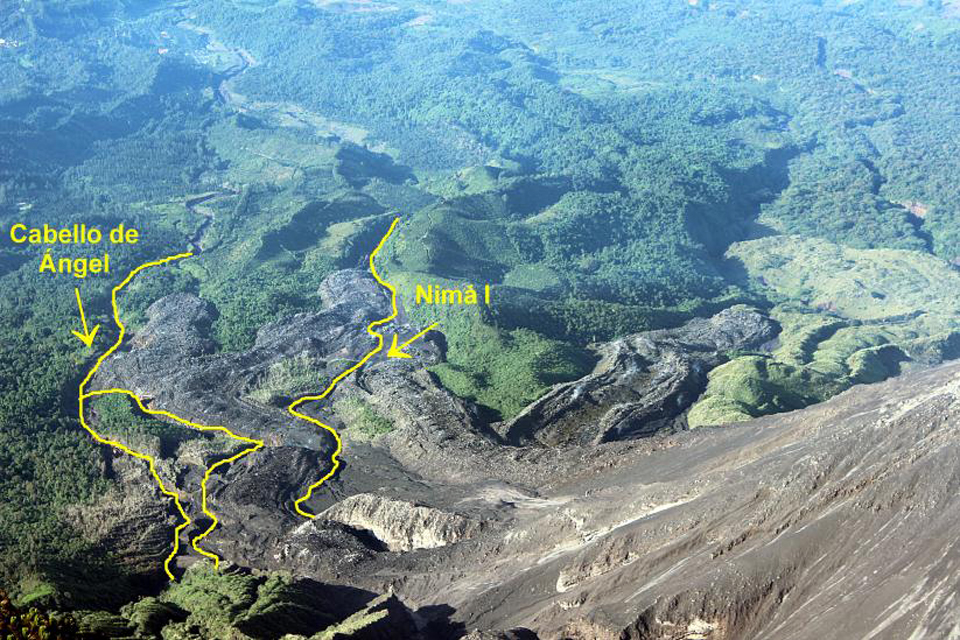 |
Figure 58. The active channels of the Cabello de Ángel and Nimá I drainages (in yellow) on the SE flank of the Caliente dome at Santa María hosted numerous pyroclastic flows and lahars. The many lahars of September 2016 traveled over parts of the channel covered by the 2015 lava flows in the Nimá I drainage. Courtesy of INSIVUMEH (Informe Mensual de Actividad Volcánica, Septiembre 2016). |
The constant explosive activity at Caliente dome during 2016 enlarged the summit crater significantly between January and the end of September 2016. In January 2016, it was about 260 m wide and 20 m deep; by 21 September, it was 340 m wide and 175 m deep according to INSIVUMEH (figure 59).
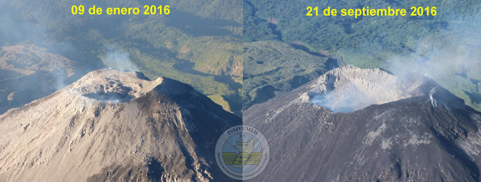 |
Figure 59. The summit crater at Santa María's Caliente dome enlarged substantially between 9 January (left) and 21 September (right) 2016 from numerous explosions. In January 2016, it was about 260 m wide and 20 m deep; by 21 September, it was 340 m wide and 175 m deep. Courtesy of INSIVUMEH (Informe Mensual de Actividad Volcánica, Septiembre 2016). |
Activity during October-December 2016. INSIVUMEH reported that a new lava dome began growing inside the summit crater of Caliente on 1 October 2016. The number of weak to moderate ash-bearing explosions increased during October, but the overall amount of energy from the explosions decreased. The STG3 seismic station recorded 25-35 weak to moderate explosions per day and the ash plumes they created generally rose to 3.3-3.5 km altitude (figure 60). There were no strong explosions reported by INSIVUMEH. The Washington VAAC reported larger ash plumes at 5.5 km altitude on 3 and 4 October that drifted a few tens of kilometers SSW from the summit before dissipating. Ashfall from these plumes was reported in the villages of San Marcos Palajunoj, Loma Linda, Monte Bello, El Faro, Patzulin and others to the S and SW. Lahars up to 20 m wide descended the Cabello de Ángel drainage on 4, 27, and 28 October.
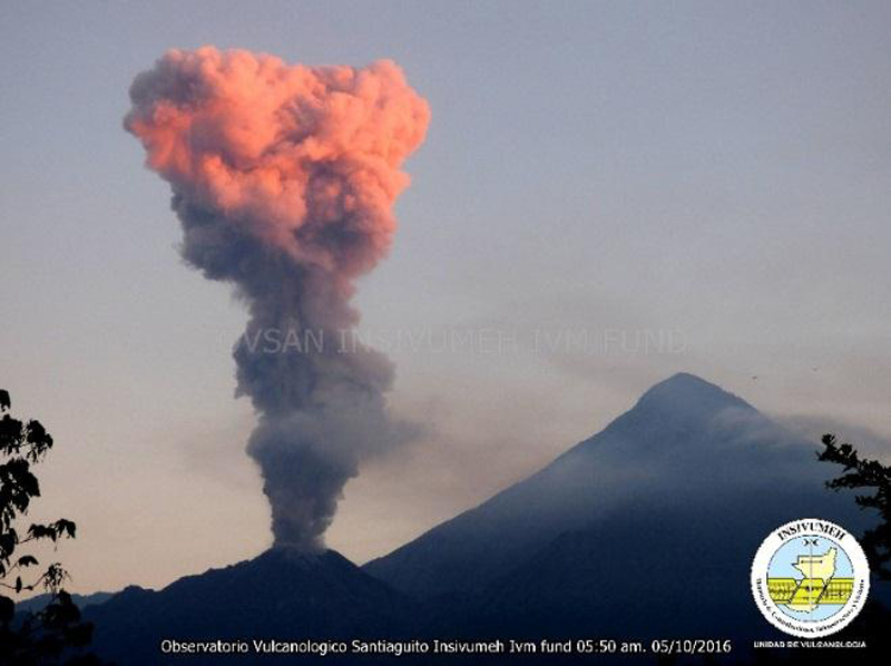 |
Figure 60. An ash-bearing emission from the Caliente dome at Santa María on 5 October 2016 rises into the sunset glow. The plume rose to an altitude of about 3.5 km before drifting SW. View from the SE. Courtesy of INSIVUMEH (Informe Mensual de Actividad Volcánica, Octubre 2016). |
The same eruptive pattern as October continued during November 2016 with 25-35 daily weak to moderate explosions that were responsible for ashfall in the villages to the SW, including Monte Claro, San José, and La Quinta and others. Steam and magmatic gasses continued to rise 100-500 m above the Caliente dome. A 15-m-wide lahar descended the Cabello de Ángel drainage on 9 November that was one meter deep, and carried material several kilometers down the Nimá and Samala drainages. The Washington VAAC reported some of the ash plumes visible up to 50 km from the dome. On 14 November, they noted two ash emissions at 4.6 km altitude. One was dissipating about 40 km SW while the second was within 15 km headed in the same direction. They also noted a small ash emission at 4.6 km altitude on 25 November drifting 20 km W.
Eruptive activity continued at a similar level during the first half of December 2016 with many weak and a few moderate explosions. During the second half of the month, the number of moderate explosions increased, but the overall number of explosions decreased. Twenty-five to thirty weak to moderate explosions per day were responsible for ash plumes rising to 3.0-3.5 km altitude. The Washington VAAC reported plumes on 24 and 30 December visible in satellite imagery at 4.6 km altitude drifting W. INSIVUMEH reported that the explosion on 30 December generated a pyroclastic flow that traveled for 2 km.
The growth of the new lava dome within the summit crater of Caliente first observed in October continued during November and December. By 18 December 2016 the new, growing dome had filled about two-thirds of the summit crater (figure 61). Heat flow at Caliente steadily declined during the second half of 2016, especially as compared with values during the first half of the year (see figure 47, BGVN (41:09). Only two MODVOLC thermal alerts were recorded after June 2016, on 29 July and 1 August. The MIROVA signal also showed a steady decrease in heat flow during this period (figure 62).
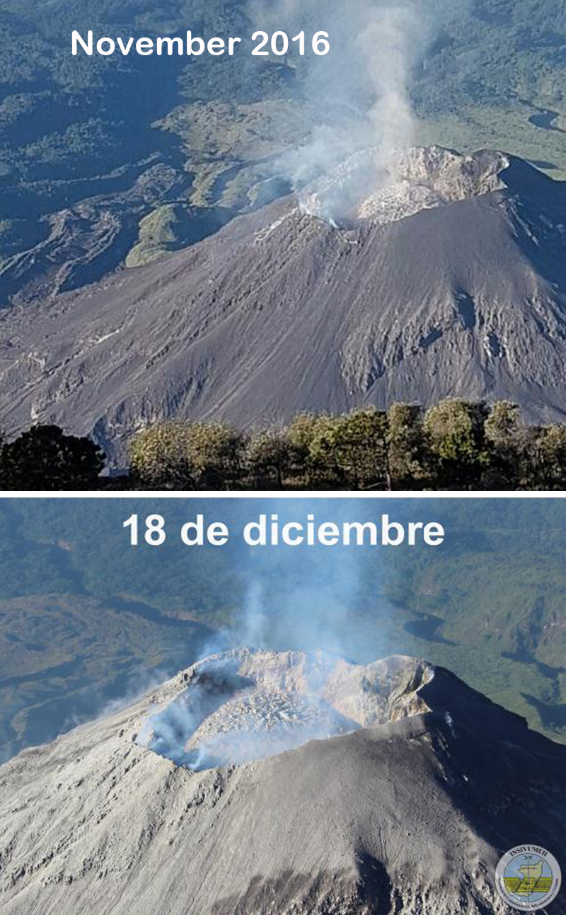 |
Figure 61. Growth of the new lava dome at the summit crater of Caliente dome at Santa María during November and December 2016. The upper image was taken by Barbara Garcia during November 2016. The lower image is dated 18 December 2016. Courtesy of INSIVUMEH (Informe Mensual de Actividad Volcánica, Noviembre and Diciembre 2016). |
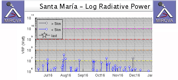 |
Figure 62. MIROVA graph of Log Radiative Power from Santa María from early June through December 2016 shows steadily declining heat flow. Courtesy of MIROVA. |
Information Contacts: Instituto Nacional de Sismologia, Vulcanologia, Meteorologia e Hydrologia (INSIVUMEH), Unit of Volcanology, Geologic Department of Investigation and Services, 7a Av. 14-57, Zona 13, Guatemala City, Guatemala (URL: http://www.insivumeh.gob.gt/); Washington Volcanic Ash Advisory Center (VAAC), Satellite Analysis Branch (SAB), NOAA/NESDIS OSPO, NOAA Science Center Room 401, 5200 Auth Rd, Camp Springs, MD 20746, USA (URL: http://www.ospo.noaa.gov/Products/atmosphere/vaac/, archive at: http://www.ssd.noaa.gov/VAAC/archive.html); Hawai'i Institute of Geophysics and Planetology (HIGP) - MODVOLC Thermal Alerts System, School of Ocean and Earth Science and Technology (SOEST), Univ. of Hawai'i, 2525 Correa Road, Honolulu, HI 96822, USA (URL: http://modis.higp.hawaii.edu/); MIROVA (Middle InfraRed Observation of Volcanic Activity), a collaborative project between the Universities of Turin and Florence (Italy) supported by the Centre for Volcanic Risk of the Italian Civil Protection Department (URL: http://www.mirovaweb.it/).
Slow growth of new lava dome, persistent ash plumes, and nearby ashfall, January-October 2017
The dacitic Santiaguito lava-dome complex on the W flank of Guatemala's Santa María volcano has been growing since 1922. The youngest of the four vents in the complex, Caliente, has been actively erupting with ash explosions, pyroclastic, and lava flows for more than 40 years. During July-September 2016, daily weak ash emissions were punctuated weekly by stronger emissions that sent ash plumes to altitudes of 3.3-6 km, and numerous pyroclastic flows were reported (BGVN 42:07). A new lava dome appeared in October and had filled half of the crater by years end; the frequency of explosions increased to 25-35 per day by December 2016. Guatemala's INSIVUMEH (Instituto Nacional de Sismologia, Vulcanologia, Meterologia e Hidrologia) and the Washington VAAC (Volcanic Ash Advisory Center) provided regular updates on the continuing activity during the time period of this report from January-October 2017.
Activity at the Caliente dome was very consistent from January through October 2017. A lava dome that began growing during October 2016 continued to slowly increase in size. Its growth generated constant steam and gas emissions that rose 100-500 m above the dome, and daily explosions with ash that generally rose to 2.8-3.3 km altitude (200-800 m above the dome). Ashfall was reported almost daily in villages and farms within 5-12 km S and SW, including San Marcos Palajunoj, Loma Linda, Monte Bello, El Patrocinio, La Florida, El Faro, Patzulin, and others. There were 15-35 explosions per day throughout this time. As the lava dome within the Caliente summit crater increased in size, more block avalanches were observed traveling tens of meters down the flanks of Caliente, outside the crater rim. Several lahars affected the major drainages during May-October.
Fifteen to twenty small to moderate daily explosions with ash emissions were typical for the Caliente dome complex during most of January 2017, in addition to constant blue and white gas emissions from the top of the lava dome. This same pattern continued throughout February, when the new dome inside the summit crater continued to grow (figure 63). By March, the dome was large enough that occasional block avalanches of fresh lava reached outside the summit crater, and descended a few tens of meters onto the flanks; the lava dome, growing since October 2016, had not quite filled the crater (figure 64).
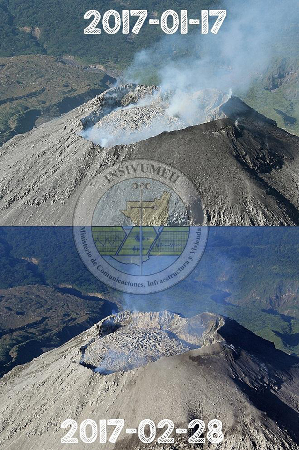 |
Figure 63. The lava dome inside the summit crater of Caliente grew noticeably between 17 January and 28 February 2017 at Santa María in this view to the S. Courtesy of INSIVUMEH (INFORME MENSUAL DE ACTIVIDAD VOLCÁNICA FEBRERO 2017). |
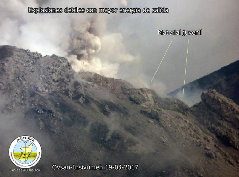 |
Figure 64. Ash and steam rises during an explosion from the new lava dome inside the summit crater of the Caliente dome of Santa María. Recently ejected blocks are steaming on the flanks close to the webcam on 19 March 2017. Courtesy of INSIVUMEH (INFORME MENSUAL DE ACTIVIDAD VOLCÁNICA MARZO 2017). |
By April 2017 the number of daily explosions had increased to 25-30, with similar energy levels and ash plume heights as earlier in the year. The Cabello de Ángel River continued downcutting through the 2014-2015 lava flows (figure 42, BGVN 41:09) creating a new channel that was 15-50 m deep (figure 65). During May, the number of daily explosions ranged from 9 to 26 (figure 66), and block avalanches from the new lava dome traveled short distances down the flanks. Two lahars were reported in May; on 6 May a lahar 30 m wide and 2.5 m deep descended the Cabello de Ángel drainage (a tributary of the Nimá I river on the S flank) carrying branches, tree trunks, and blocks up to 2 m in diameter. A smaller lahar on 31 May traveled down the Nimá I drainage and dragged smaller blocks and tree trunks down the channel.
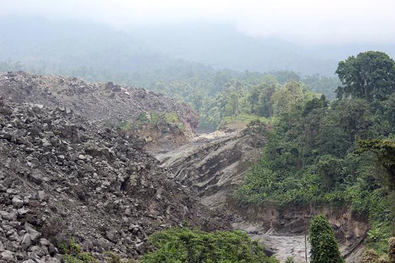 |
Figure 65. The Cabello de Ángel river cuts new channels through the 2014-2015 lava flows on the SE flank of Caliente dome at Santa María during April 2017. Courtesy of INSIVUMEH (INFORME MENSUAL DE ACTIVIDAD VOLCÁNICA ABRIL 2017). |
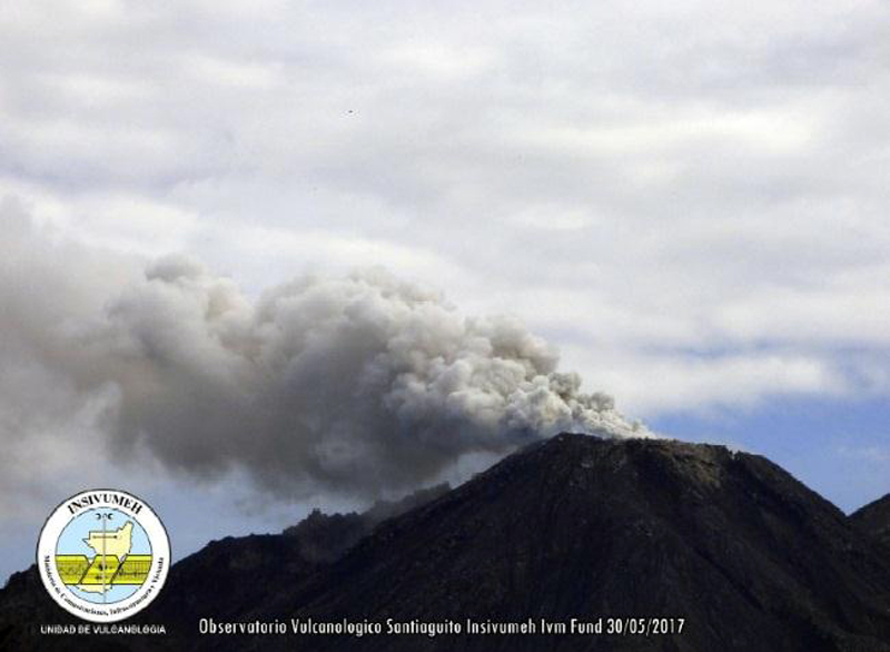 |
Figure 66. A moderate explosion on 30 May 2017 from Santiaguito at Santa María sends an ash plume to 2.6 km altitude that then drifted SW. Courtesy of INSIVUMEH (INFORME MENSUAL DE ACTIVIDAD VOLCÁNICA Mayo 2017). |
Explosions during June 2017 continued at the rate of 14-36 per day, with ash plumes rising to 2.7-3.3 km altitude (figure 67). Juvenile material continued to fill and overtop the crater rim, creating weak block avalanches down the flanks. Increased precipitation during June resulted in five lahars descending the Cabello de Ángel, Nimá I, and San Isidro drainages on 1, 5, 7, 9, and 16 June. They ranged in size from 15 to 25 m wide and 1 to 1.5 m high, and transported blocks 1-2 m in diameter. A larger lahar on 1 June that traveled down the Cabello de Ángel drainage was 30 m wide and 2 m high.
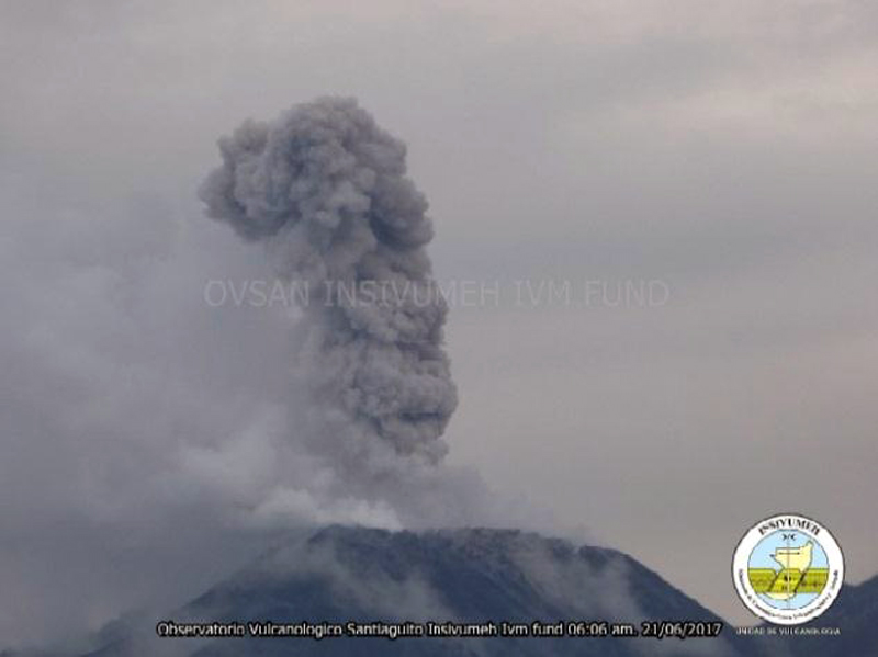 |
Figure 67. An ash plume at Santa María's Santiaguito complex on 21 June 2017 rises to 2.9 km. Courtesy of INSIVUMEH (INFORME MENSUAL DE ACTIVIDAD VOLCÁNICA Junio 2017). |
Similar explosive activity continued during July. On 5 July, a moderately-sized lahar descended the Cabello de Ángel drainage, a tributary of the Nimá I river. Near the El Faro estate, the lahar was 30 m wide and 1 m deep, and carried blocks 50 cm in diameter. On 14 July, another lahar traveled down the Nimá I drainage, which is a tributary of the Samalá. By August the summit crater of Caliente was nearly filled with the new lava dome, and overflows of block avalanches were more frequent, mostly traveling down the E flank (figure 68). A moderately-sized lahar descended the Nimá I drainage on 9 August.
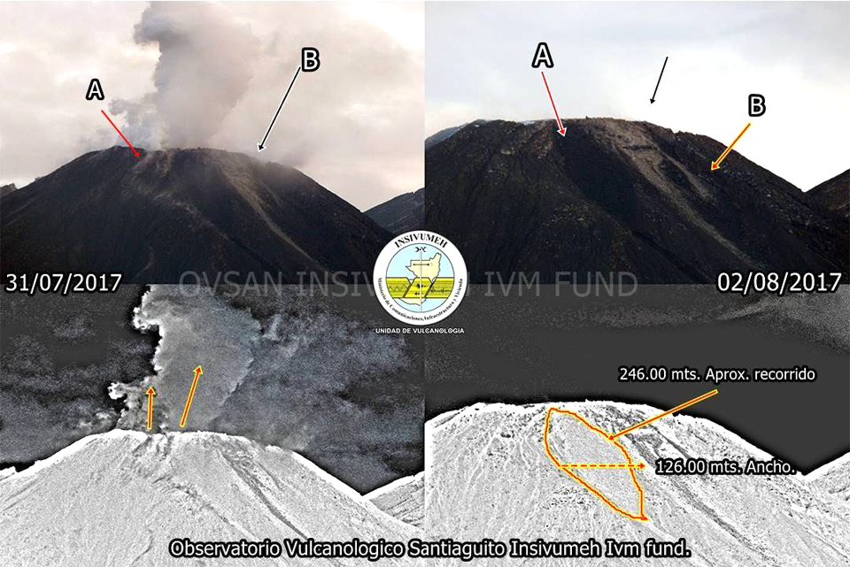 |
Figure 68. Fresh block avalanches were visible covering an area about 126 m wide and 246 m long near the summit of Caliente at Santa María when images from 31 July (left) and 2 August 2017 (right) were compared. Most of the block avalanches traveled down the east flank (A), but smaller avalanches traveled shorter distances down the NE flank (B). Courtesy of INSIVUMEH (Reporte Semanal de Monitoreo: Volcán Santiaguito (1402-03), Semana del 29 de julio al 04 de agosto de 2017). |
Explosions with ash plumes rising hundreds of meters above the crater rim continued daily during September and October, and sent block avalanches down the NE and SE flanks of the dome. INSIVUMEH reported that on 11 October 2017 a 12-m-wide and 1.5-m-high lahar descended the Cabello de Ángel and the Nimá I drainages, carrying blocks up to 1 m in diameter. On 13 October, the seismic network detected moderate-to-strong lahars in the Cabello de Ángel and the Nimá I drainages triggered by heavy rain.
Relatively few VAAC reports were issued for Santa María during 2017 compared with the previous two years. The Washington VAAC observed an ash plume in satellite imagery drifting 15 km W at 4.6 km altitude on 14 January. Morning visible imagery on 1 February showed an ash plume 25 km SW at 3.8 km altitude. An ash emission was observed on 27 February a few kilometers WSW at or slightly above the summit. Multiple small puffs of ash extended 55 km WSW of the summit on 9 March, at 4.6 km altitude. An ash plume was centered 15 km NW of the summit at 3.8 km altitude and rapidly dissipating on 4 April. The next VAAC observation, on 2 June, was a small puff of ash located 30 km S of the summit. On 6 September, possible volcanic ash was drifting SW of the summit at 4.3 km altitude.
Infrared MODIS satellite data suggest low-level, persistent activity at Santa María throughout January-October 2017 (figure 69). This is consistent with photographs of a slowly growing lava dome at the summit, and persistent low-energy explosions with ash emissions and block avalanches during the year. There were no MODVOLC thermal anomalies during this time.
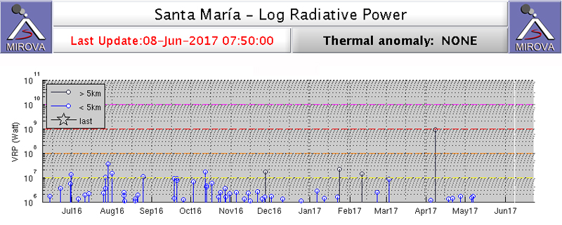 |
Figure 69. Infrared MODIS thermal data graphed through the MIROVA system indicates a low but persistent level of thermal activity at Santa María for the year ending on 8 June 2017. This is consistent with the observations of a slowly growing lava dome inside the summit crater. Courtesy of MIROVA. |
Information Contacts: Instituto Nacional de Sismologia, Vulcanologia, Meteorologia e Hydrologia (INSIVUMEH), Unit of Volcanology, Geologic Department of Investigation and Services, 7a Av. 14-57, Zona 13, Guatemala City, Guatemala (URL: http://www.insivumeh.gob.gt/ ); Washington Volcanic Ash Advisory Center (VAAC), Satellite Analysis Branch (SAB), NOAA/NESDIS OSPO, NOAA Science Center Room 401, 5200 Auth Rd, Camp Springs, MD 20746, USA (URL: www.ospo.noaa.gov/Products/atmosphere/vaac, archive at: http://www.ssd.noaa.gov/VAAC/archive.html); MIROVA (Middle InfraRed Observation of Volcanic Activity), a collaborative project between the Universities of Turin and Florence (Italy) supported by the Centre for Volcanic Risk of the Italian Civil Protection Department (URL: http://www.mirovaweb.it/).
Daily explosions with minor ash and block avalanches at Caliente, November 2017-April 2018
The dacitic Santiaguito lava-dome complex on the W flank of Guatemala's Santa María volcano has been growing since 1922. The youngest of the four vents in the complex, Caliente, has been actively erupting with ash explosions, pyroclastic, and lava flows for more than 40 years. During January-October 2017 (BGVN 42:12), daily weak ash emissions sent ash plumes to altitudes around 3.3 km, and ashfall was frequent in villages and farms within 12 km S and SW. The lava dome that appeared within the summit crater of Caliente in October 2016 continued to grow, increasing the frequency of block avalanches moving down the flanks. Several lahars affected the major drainages during May-October. Guatemala's INSIVUMEH (Instituto Nacional de Sismologia, Vulcanologia, Meterologia e Hidrologia) and the Washington VAAC (Volcanic Ash Advisory Center) provided regular updates on the continuing activity during the time period of this report from November 2017-April 2018.
Activity at Santa Maria was very consistent with little variation during November 2017-April 2018. Plumes of steam with minor magmatic gases rose continuously from the Caliente crater 300-500 m above the summit, drifting SW or SE before dissipating. In addition, tens of daily explosions with varying amounts of ash rose to altitudes of around 3.5-4.0 km and usually traveled short distances of 20-30 km before dissipating. The longest-lived plume, on 22 March 2018 drifted 100 km before dispersing. Almost all of the plumes drifted SW or SE; minor ashfall occurred in the mountains and was reported at the fincas up to 15 km away in those directions several times each month. Continued growth of the lava dome at Caliente resulted in block avalanches descending its flanks every day. The MIROVA plot of thermal energy during this time shows a consistent level of heat flow with minor variations. The spike of strongest heat flow in late March 2018 corresponds with the largest ash plume reported (figure 70) for the period.
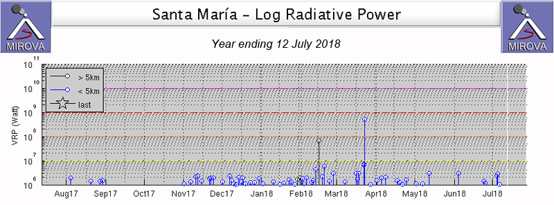 |
Figure 70. MIROVA plot of thermal energy from Santa Maria for the year ending 12 July 2018 shows persistent low levels of heat flow. The spike at the end of March 2018 corresponds to the largest reported ash plume for the period. Courtesy of MIROVA. |
Activity during November 2017-January 2018. During November 2017, persistent steam plumes rose 100-500 m above the summit crater at Caliente, and generally drifted SE. Tens of weak explosions daily created ash plumes that rose to about 3.2 km altitude and drifted usually SE. These resulted in ashfall reported near Finca San José on 9, 26, and 28 November, and in the mountains around Finca la Florida on 27 November. The Washington VAAC reported an ash emission seen in satellite imagery on 18 November drifting S about 15 km from the summit at 4.3 km altitude. Block avalanches were reported daily, they usually extended down the SE flank, occasionally making it to the base of the dome.
Characteristic steam plumes rising 100-500 m continued daily throughout December 2017. Numerous daily weak to moderate explosions generated ash plumes that rose to around 3.0-3.3 km altitude and drifted most often to the SW. Weak to moderate, and occasionally strong block avalanches descended the SE flank of the dome most days.
The Caliente dome maintained constant degassing with mostly steam plumes and occasional magmatic gas throughout January 2018 (figure 71). The plumes rose 50-300 m above the dome; most plumes came from the crater, but a few rose from fissures on the flanks. Explosions with ash plumes rose to 2.8-3.5 km altitude and generally drifted W or SW (figure 72). The seismic station registered 15-21 weak to moderate explosions per day. Ash generally drifted to the E or SE and caused ashfall in the regions around the fincas of San José, Patzulin, La Quina and others. Finca San José reported ashfall in the vicinity on 6, 7, and 9 January, and El Faro noted nearby ashfall on 9 January. A small plume with minor ash content was noted in satellite imagery by the Washington VAAC on 10 January drifting E at 4.3 km altitude. Ash emissions extended about 35 km SW before dissipating on 12 January, also at 4.3 km. Weak and moderate-size block avalanches occurred daily with blocks generally descending the SE or E flank of the dome.
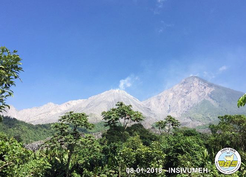 |
Figure 71. A typical plume of steam and magmatic gas rose from the Caliente vent at Santa Maria on 8 January 2018. Courtesy of INSIVUMEH (Informe mensual de actividad volcánica enero 2018, Volcán Santiaguito, 1402-03). |
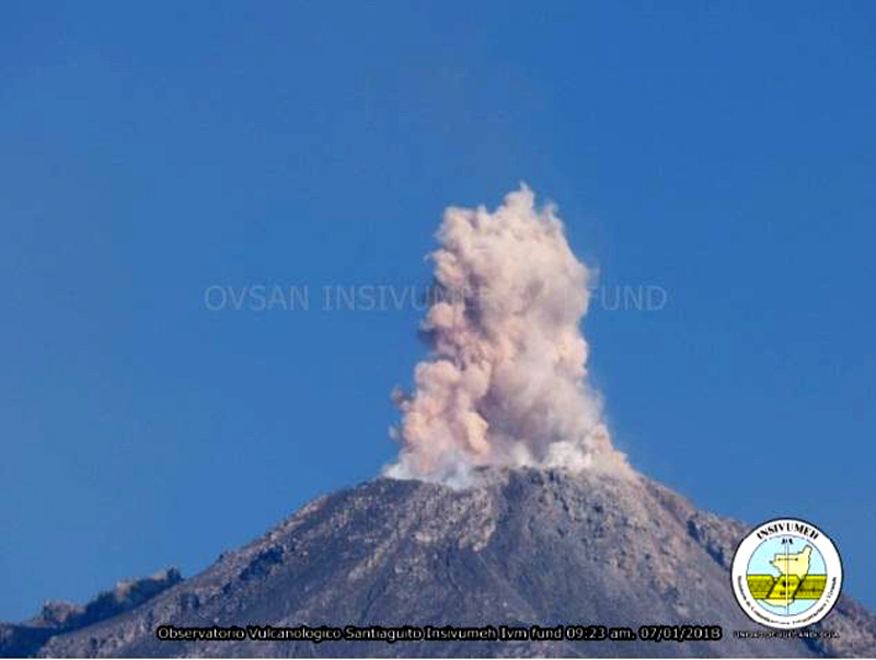 |
Figure 72. An explosion at the Caliente dome of Santa Maria on 7 January 2018 sent ash a few hundred meters above the summit crater. Courtesy of INSIVUMEH (Informe mensual de actividad volcánica enero 2018, Volcán Santiaguito, 1402-03). |
Activity during February-April 2018. Plumes of steam and gas continued rising daily to a few hundred meters above Caliente during February 2018. Weak and moderate explosions with steam and ash rose to 2.6-3.2 km altitude and drifted variably S, SE, W, or SW during the month (figure 73). Explosions averaged about 14 per day. Ashfall was reported in the fincas to the E and SE during the first week, including at Finca San José on 5 February, and la Florida on 10 February; they occurred in the mountainous areas W and SW during the rest of the month. Ashfall was also reported around the perimeter of the volcano several times during the last week of the month. The Washington VAAC reported an ash plume at 4.6 km altitude on 12 February drifting rapidly W, and a thin veil of gas and minor ash on 28 February extending about 15 km SW from the summit at 4.3 km altitude. Observations of repeated block avalanches down the SE flank throughout the month concurred with thermal measurements on 28 February that showed the hottest areas of the dome at the summit and on the SE flank (figure 74).
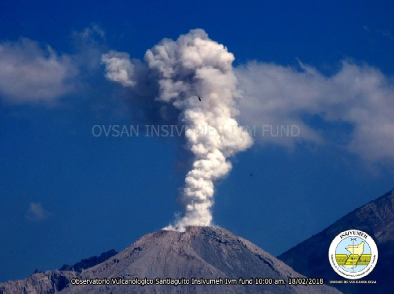 |
Figure 73. An explosion of steam and ash rose from Caliente at Santa Maria on 18 February 2018. Courtesy of INSIVUMEH (Reporte Semanal de Monitoreo: Volcán Santiaguito (1402-03), Semana del 17 al 23 de febrero de 2018). |
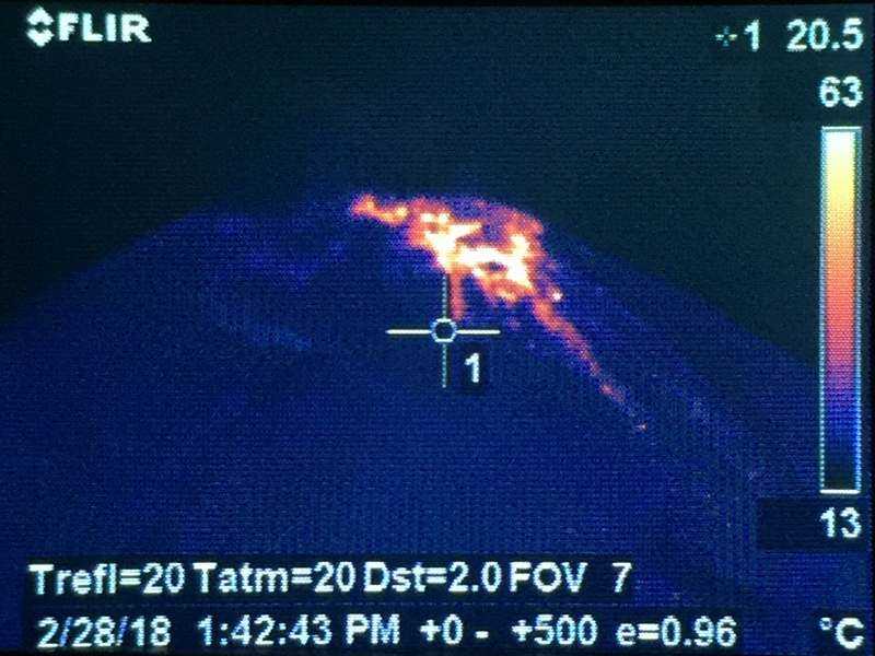 |
Figure 74. Material inside the summit crater of Caliente at Santa Maria measured about 140°C on 28 February 2018, and showed the warmest region on the SE flank where most of the block avalanches occurred. Courtesy of INSIVUMEH (Reporte Semanal de Monitoreo:, Volcán Santiaguito (1402-03), Semana del 24 de febrero al 02 de marzo de 2018). |
Block avalanches down the SE and S flanks of Caliente from the growing summit dome persisted at weak to moderate levels throughout March 2018 (figure 75). Ten to twenty daily ash-bearing explosions usually rose to about 3.2 km altitude and drifted SW or SE causing ashfall around the perimeter. Ashfall was reported in the mountains around Finca San José on 4-6, 9, 20, and 23 March, and in the Palajunoj area on 11 March. Steam plumes rising from the summit of Caliente to 2.9-3.1 km altitude drifting SE or SW were a daily feature of activity (figure 76). The Washington VAAC reported an ash plume on 5 March that rose to 4.6 km altitude and drifted SW before dissipating within 15 km of the summit. On 21 March, an emission was observed in satellite imagery that extended about 35 km SW from the summit at 4.6 km altitude. Another ash plume the following day also rose to 4.6 km altitude and extended almost 100 km SW before dissipating. That same day, 22 March, MODVOLC issued four thermal alerts for Santiaguito, and the MIROVA system showed a spike in thermal activity as well (figure 70).
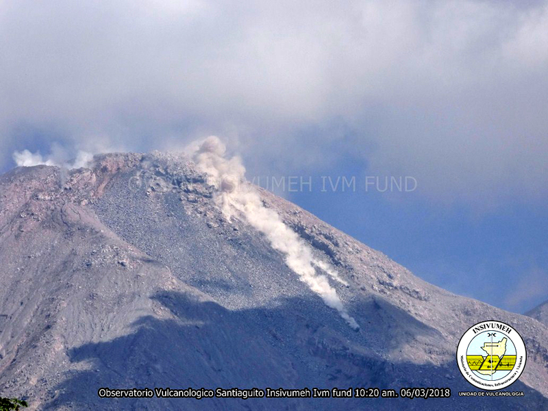 |
Figure 75. Block avalanches descended the SE flank of Caliente at Santa Maria on 6 March 2018. Courtesy of INSIVUMEH (Reporte Semanal de Monitoreo:, Volcán Santiaguito (1402-03), Semana del 03 al 09 de marzo de 2018). |
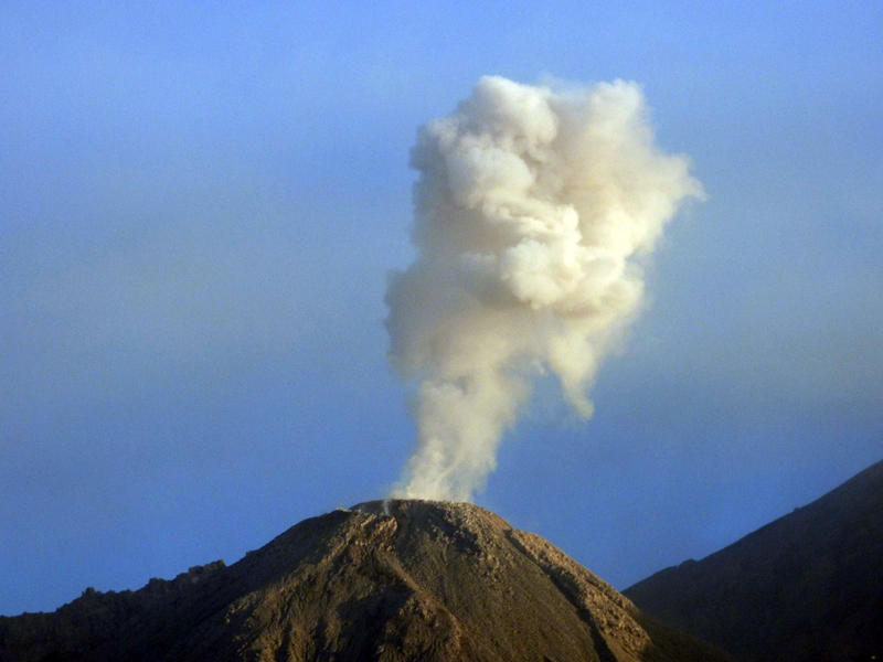 |
Figure 76. A typical steam plume rose from Caliente summit during the last week of March 2018. Courtesy of INSIVUMEH (Reporte Semanal de Monitoreo: Volcán Santiaguito (1402-03), Semana del 17 al 23 de marzo de 2018). |
Multiple daily explosions with ash rose up to 3.2 km altitude during April 2018. The plumes drifted SW or SE, spreading fine-grained ash over the nearby hills. Finca San José reported ashfall on 2 April and the Palajunoj area reported ashfall on 10, 13, 15, and 17 April. Abundant degassing of mostly steam plumes at the Caliente crater continued throughout the month, as did the constant descent of block avalanches down the SE flank.
Information Contacts: Instituto Nacional de Sismologia, Vulcanologia, Meteorologia e Hydrologia (INSIVUMEH), Unit of Volcanology, Geologic Department of Investigation and Services, 7a Av. 14-57, Zona 13, Guatemala City, Guatemala (URL: http://www.insivumeh.gob.gt/ ); MIROVA (Middle InfraRed Observation of Volcanic Activity), a collaborative project between the Universities of Turin and Florence (Italy) supported by the Centre for Volcanic Risk of the Italian Civil Protection Department (URL: http://www.mirovaweb.it/); Hawai'i Institute of Geophysics and Planetology (HIGP) - MODVOLC Thermal Alerts System, School of Ocean and Earth Science and Technology (SOEST), Univ. of Hawai'i, 2525 Correa Road, Honolulu, HI 96822, USA (URL: http://modis.higp.hawaii.edu/); Washington Volcanic Ash Advisory Center (VAAC), Satellite Analysis Branch (SAB), NOAA/NESDIS OSPO, NOAA Science Center Room 401, 5200 Auth Rd, Camp Springs, MD 20746, USA (URL: www.ospo.noaa.gov/Products/atmosphere/vaac, archive at: http://www.ssd.noaa.gov/VAAC/archive.html).
Ash plumes, degassing, and avalanches continue during May-October 2018 with occasional lahars
Santa Maria is one of the most active volcanoes of Guatemala. The volcano is composed of a large edifice that reaches over 3.7 km above sea level; the Santiaguito dacitic dome complex to the SW, with the active Caliente dome, rises to a height of over 2.5 km (figure 77). The Santiaguito dome complex is situated in a large crater that formed during a catastrophic eruption in 1902. Growing since 1922, this complex has recently been characterized by dome-growth activity that includes degassing, ash plumes, avalanches, pyroclastic flows, lava flows, and lahars. This report summarizes activity from May through October 2018, and is based on reports by Guatemala's INSIVUMEH (Instituto Nacional de Sismologia, Vulcanologia, Meterologia e Hidrologia) and satellite data. During this period, activity consisted of degassing, ash plumes, and avalanches at the Caliente dome, and lahars in multiple tributaries. Intermittent low-power thermal anomalies were detected throughout this period (figure 78).
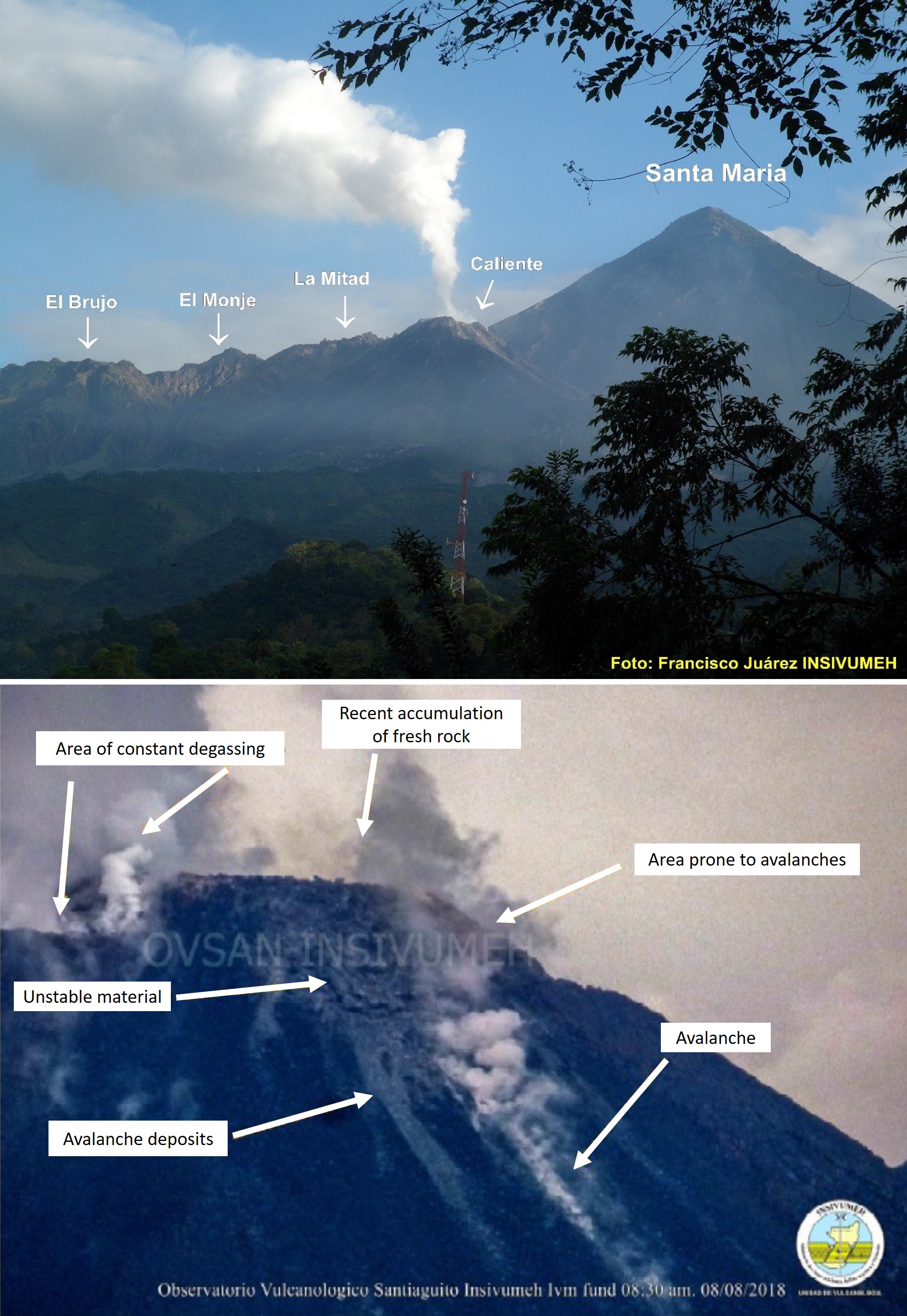 |
Figure 77. Santa Maria volcano consists of an older, larger peak to the NW and the Santiaguito dome complex to the SW. Top: The currently-active dome, Caliente, is situated in the 1.5-km-wide collapse crater. Bottom: The Caliente dome has fresh, unstable material accumulating in the crater that is prone to avalanches; image of the dome on 8 August 2018 (4-10 August 2018 weekly report). Courtesy of INSIVUMEH. |
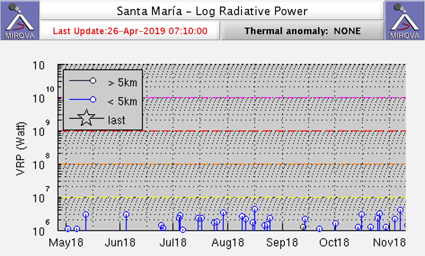 |
Figure 78. Log radiative power MIROVA plot of MODIS infrared data at Santa Maria for May through November 2018. Courtesy of MIROVA. |
Throughout May, active degassing of the dome produced white plumes up to 3.2 km above sea level. Frequent weak to moderate explosions produced white and gray ash plumes up to 3.3 km that were dispersed to the SW, W, and SE. As many as 15 explosions were recorded per day. Avalanches frequently occurred on the SE flank of the Caliente dome. The first lahar of the year was generated by rainfall on 10 May and traveled down the Cabello de Angel-Nimá I river. The lahar was composed of abundant fine material with larger branches and blocks up to 1 m in diameter, and it smelled of sulfur. The lahar deposit was 15 m wide and 1.2 m thick. A second lahar descended along the same path on 24 May and emplaced a deposit with a width of 18 m, a depth of 2 m, and blocks up to 2 m in diameter.
During June, white plumes associated with degassing of the Caliente dome often reached altitudes of 2.9 km, with a maximum of 3.9 km on 5 June. An average of 9-11 weak to moderate explosions per day ejected white and gray ash plumes up to 3.1-3.3 km altitude that were dispersed to the SW, W, and SE (figures 79 and 80). Ashfall was reported in Monte Claro on 26 June. Avalanches were recorded most days on the SE side of the dome due to ongoing growth. Lahars were reported on 13, 14, and 16 June down the Nimá I and Cabello de Ángel tributaries of the Samalá River (figures 81 and 82).
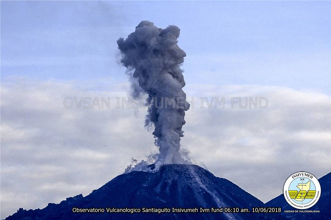 |
Figure 79. A moderate explosion from the Caliente dome at Santa Maria generated an ash plume on 10 June 2018. Courtesy of INSIVUMEH (9-15 June 2018 weekly report). |
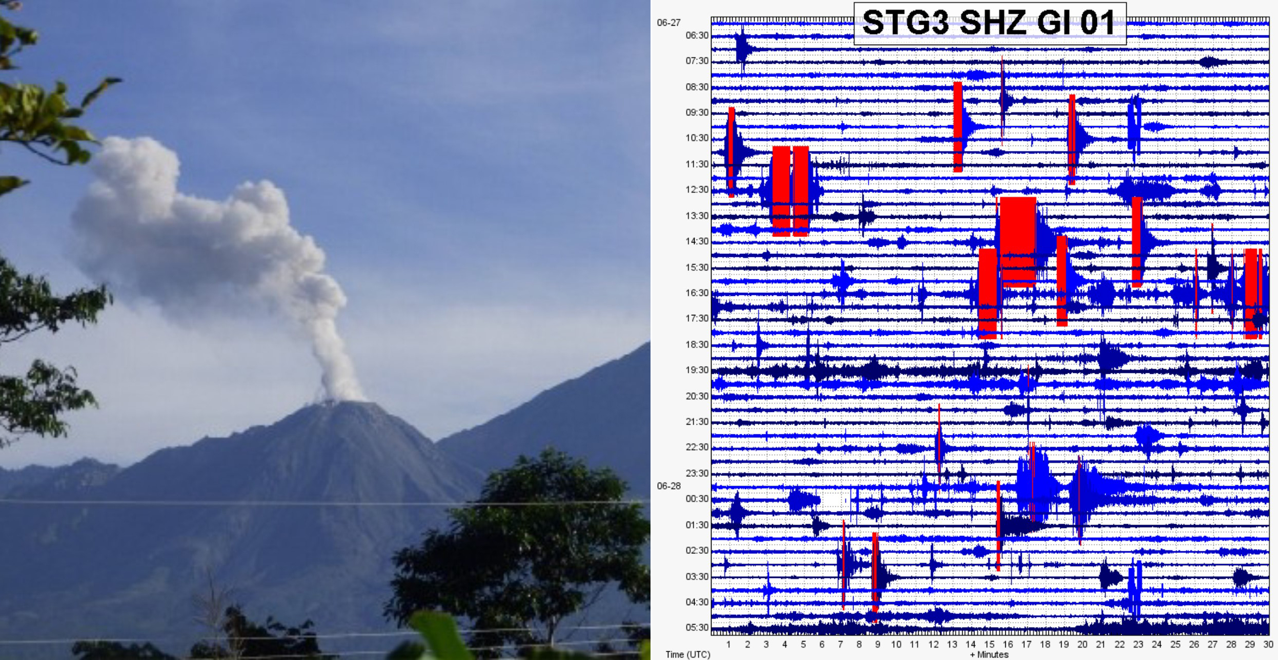 |
Figure 80. During the week of 23-30 June 2018 there was an average of 11 weak to moderate explosions per day at Santa Maria, as well as short avalanches on the S side of the dome. Left: a moderate explosion producing a plume from the Caliente dome. Right: Seismicity associated with activity of the dome including weak to moderate explosions. Courtesy of INSIVUMEH (modified from 23-30 2018 June report). |
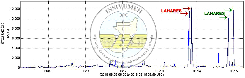 |
Figure 81. Real-time Seismic-Amplitude Measurement (RSAM) graph showing four peaks corresponding to lahars on the 13 and 14 June 2018. The lahars traveled from Santa Maria down the Nimá I and Cabello de Ángel tributaries of the Samalá River. Courtesy of INSIVUMEH (9-15 June 2018 weekly report). |
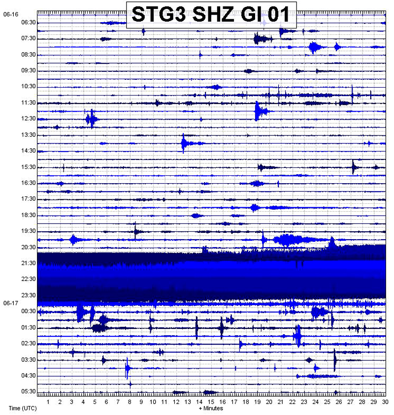 |
Figure 82. The seismic signal produced by a lahar at Santa Maria on 16 June 2018. The lahar traveled down the Nimá I river channel. Courtesy of INSIVUMEH (16-22 June 2018 weekly report). |
Throughout July, degassing of the dome and fumarolic activity produced white plumes reaching 3 km. These plumes were dominantly directed towards the SW and SE, and on a few days towards the N and W. Explosions frequently produced white and gray ash plumes up to 11 times per day (figure 83). Ash plumes often reached approximately 3.2 km altitude, drifted SE, SW, and W, and frequently deposited ash on the flanks. On 4 July an explosion produced incandescent material up to 150 m above the crater and the accompanying sound was heard in areas including El Palmar, Pueblo Nuevo, and San Felipe Retalhuleu. Avalanches most often occurred on the SE flank of the dome, with some occurring on the N, NE, and W flanks (figure 84). Incandescence was observed on the 11 July.
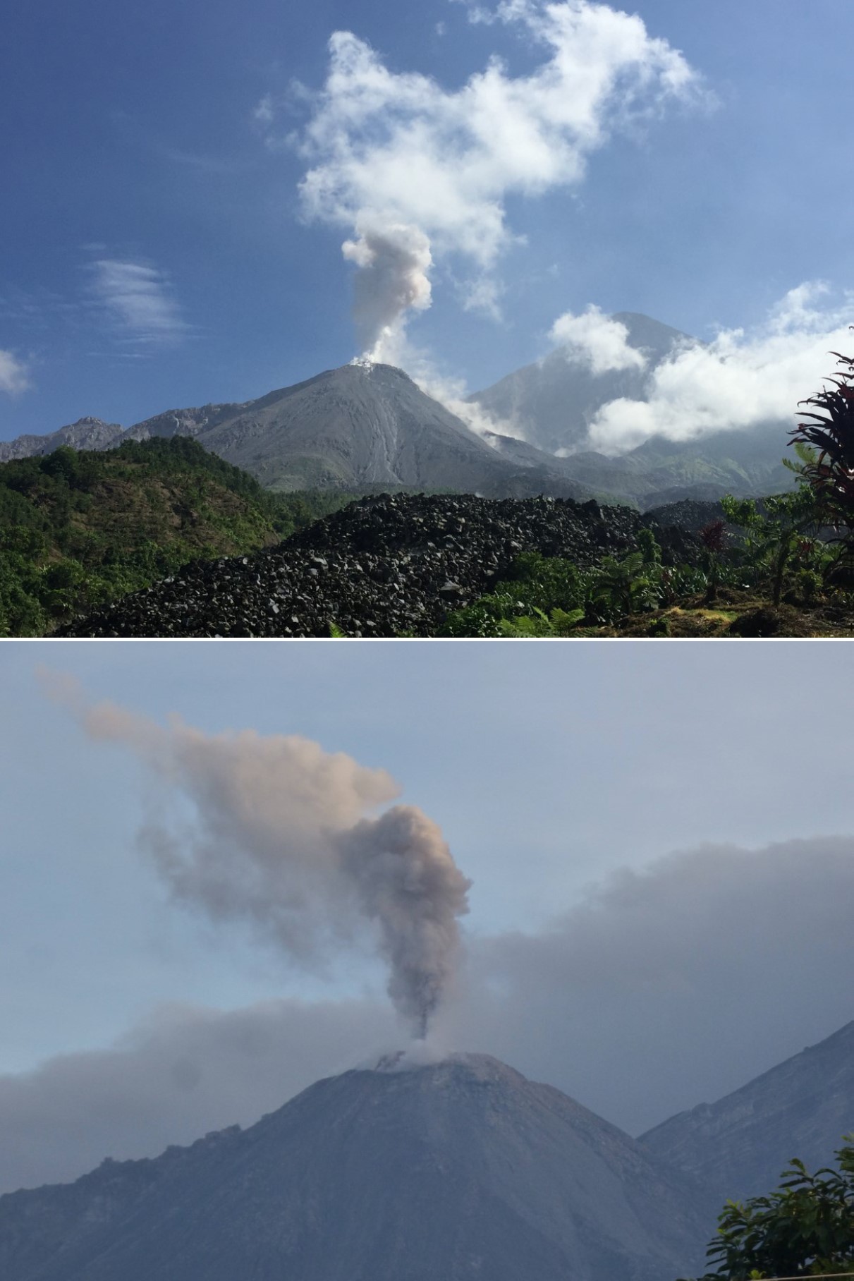 |
Figure 83. Examples of plumes from moderate (top) and weak (bottom) explosions at Santa Maria's Caliente dome in July 2018. Courtesy of INSIVUMEH (July 1-6 and 21-27 July 2018 weekly reports, respectively). |
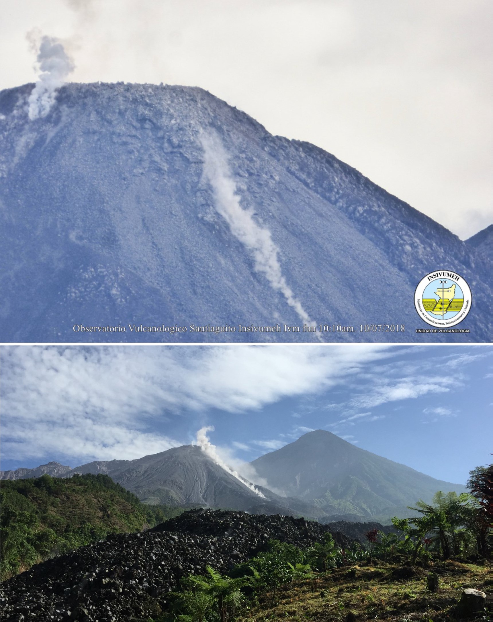 |
Figure 84. Avalanches on Santa Maria's Caliente dome during July 2018. Top: A small avalanche on the SE flank of the dome (7-13 July 2018 weekly report). Bottom: A moderate avalanche on the SE flank of the dome (21-17 July 2018 weekly report). Courtesy of INSIVUMEH. |
Through August, degassing of the dome regularly produced white plumes up to a maximum observed altitude of 3.2 km (figure 85). Explosions generated white and gray ash plumes up to 3.1-3.3 km on most days, with a maximum of 13 explosions recorded per day. Gas-and-steam and ash plumes were often dispersed to the SE and sometimes towards the W. Ashfall often occurred on the slopes. Avalanches on the dome were recorded most days on the SE flank and sometimes on the E, NE, and W flanks. On 17 August at 1330 a lahar emplaced a deposit 18 m wide and 2.5 m thick, with blocks up to 3 m in diameter.
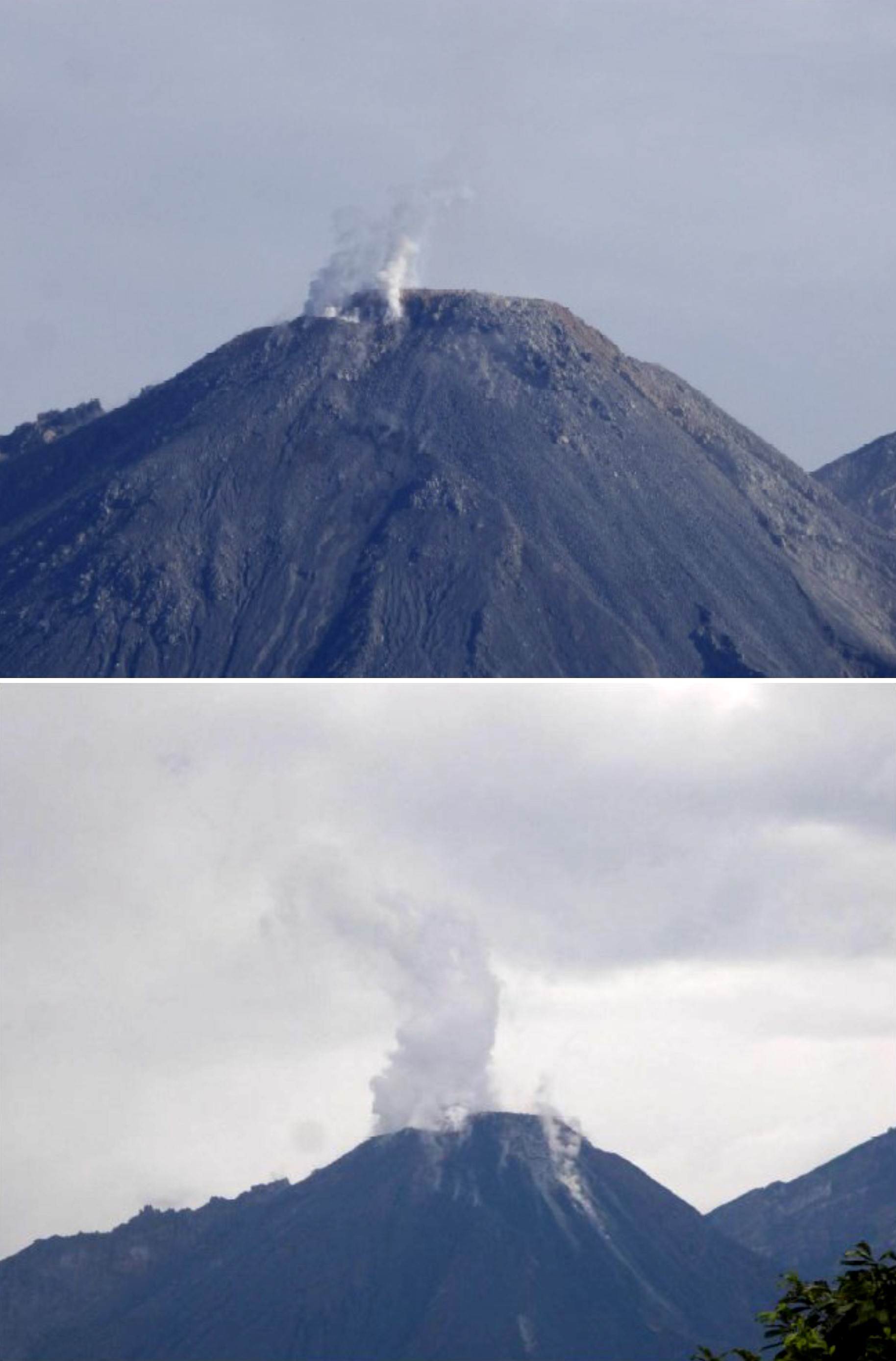 |
Figure 85. Degassing of the Santa Maria Caliente dome forming white plumes during August 2018. Courtesy of INSIVUMEH (27 July-3 August 2018 and 4-10 August 2018, respectively). |
Throughout September, degassing and fumarole activity of the Caliente dome produced white plumes up to 3.1 km. Explosions produced ash plumes that reached altitudes of 3.3 km up to 13 times per day. Degassing and ash plumes were most often dispersed to the SW, and sometimes to the W and SE. Red discoloration of ash was noted on 4 September due to the oxidation of the dome rock where the explosion was generated (figure 86). Ashfall often occurred within the proximity of the volcano. Avalanches were often reported as constant on the SE flank of the dome and sometimes occurring on the NE and E flanks. On 12 September a lahar was recorded traveling down both tributaries of the Samalá River. A larger lahar was generated on 20 September in the San Isidro-Tambor tributaries of the Samala River with a width of 25 m and a thickness of 2 m. The lahar carried tree trunks and branches, and blocks up to 2 m in diameter. A third lahar occurred on 24 September down the Cabello de Ángel River, with a width of 15 m, a thickness of 1.5 m, and carrying blocks up to 2 m in diameter.
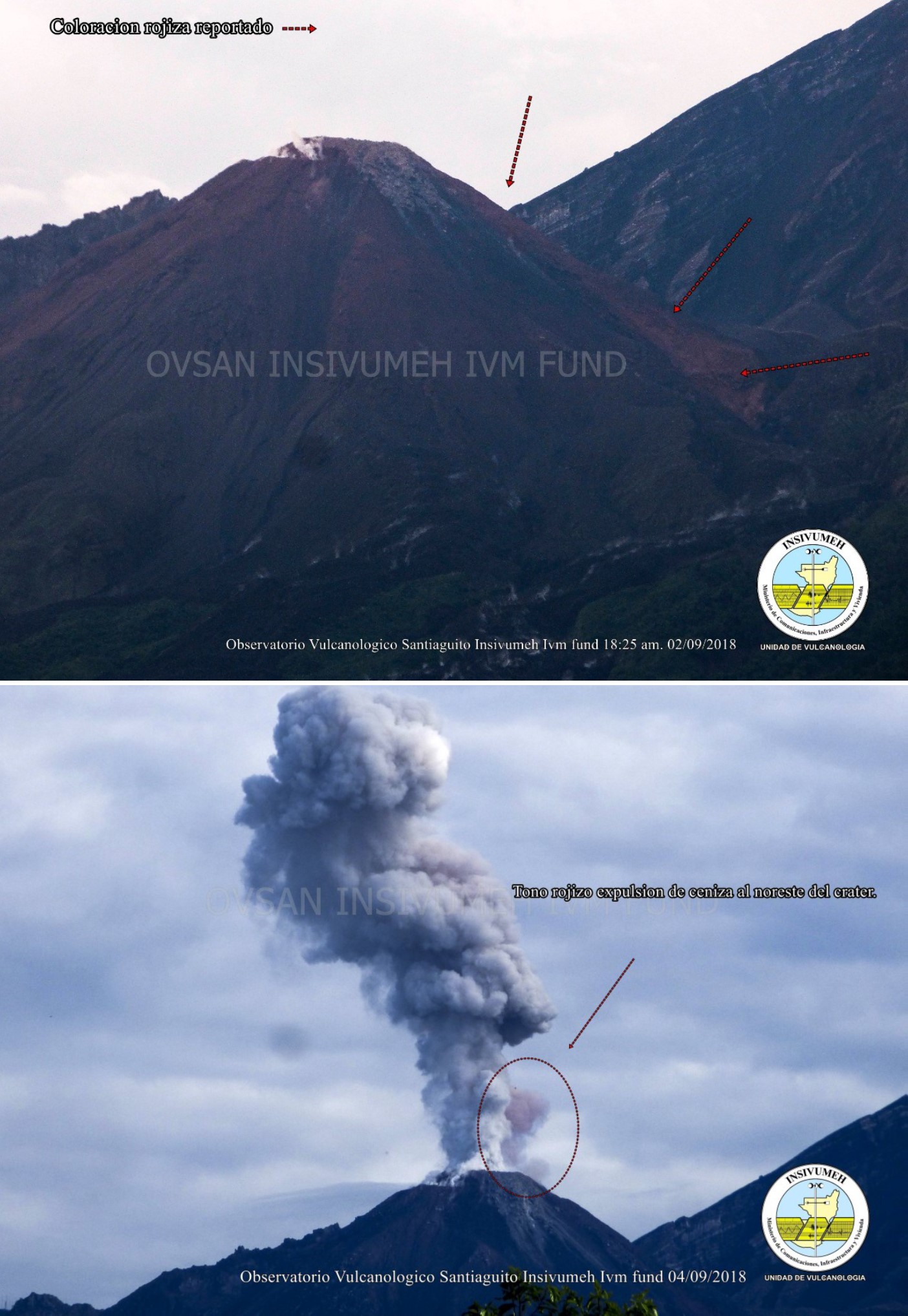 |
Figure 86. Oxidation in and around the crater of Caliente dome (top) at Santa Maria occurs due to the high temperatures and causes red discoloration of the rock. This leads to discolored plumes as seen on 4 September 2018 (bottom). Courtesy of INSIVUMEH (1-7 October 2018 weekly report). |
Degassing at the dome during October produced white plumes to a maximum altitude of 3.2 km (figure 87). Explosions generated white and gray ash plumes up to 3.2 km, with up to 11 explosions recorded per day and an average of 8-9 per day. Plumes were often directed towards the SE, and sometimes to the W and NW. Ashfall frequently occurred on the slopes and was reported in Monte Claro on 16 and 26 October. Avalanches were frequent on the SE flank of the dome, and sometimes occurred on the W and NE flanks (figure 88). Incandescent material was observed during explosions on the 23rd. Two lahars were generated on 9 October; one traveled down the Cabello de Ángel river channel with a width of 20 m, a thickness of 2 m, and carrying blocks as large as 3 m in diameter. The second was 15-m-wide with a thickness of 1 m and blocks as large as 2 m in diameter which traveled down the San Isidro River.
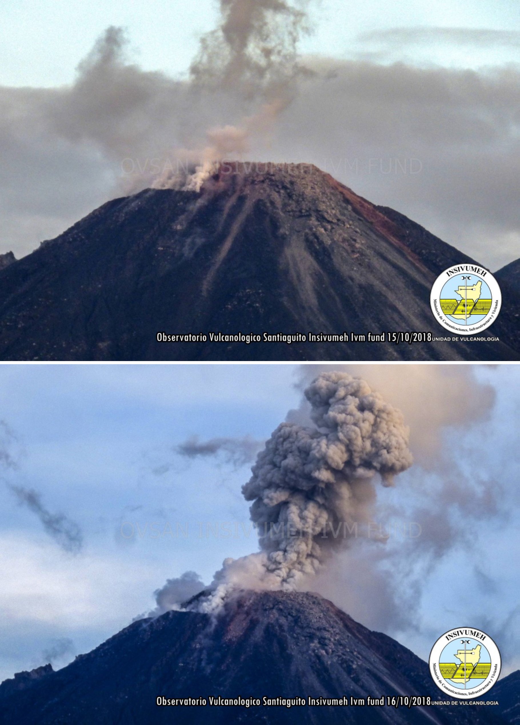 |
Figure 87. The Caliente dome of Santa Maria, the active dome of the Santiaguito dome complex. Top: degassing at the edge of the crater on 15 October 2018. Bottom: A moderate explosion that produced an ash plume with abundant gas on 16 October. Courtesy of INSIVUMEH (13-19 October 2018 weekly report). |
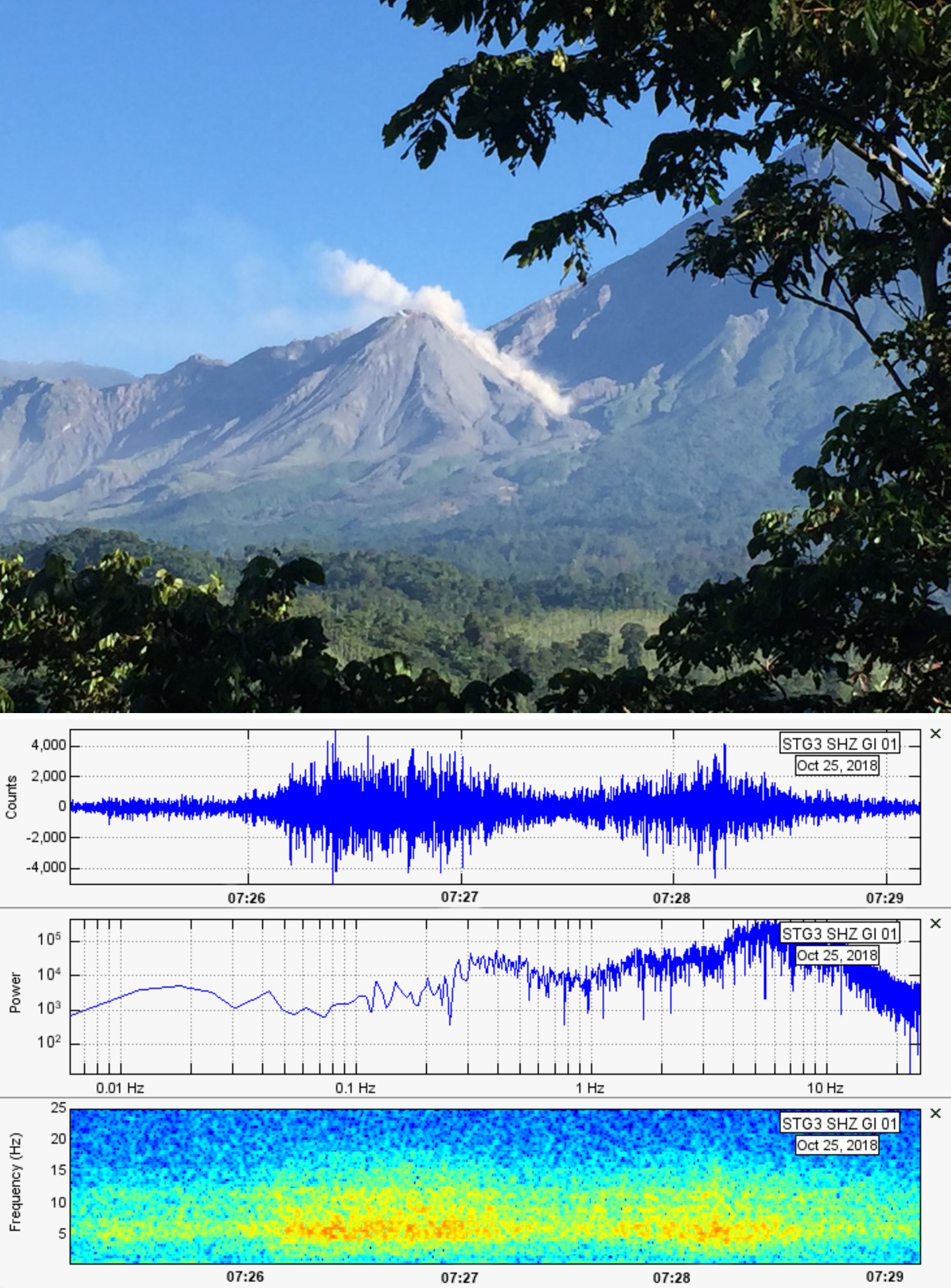 |
Figure 88. An avalanche on the NE flank of the Caliente dome of Santa Maria on 25 October 2018 with the corresponding seismic signal that lasted 3 minutes and 40 seconds. Courtesy of INSIVUMEH (20-26 October 2018 weekly report). |
Information Contacts: Instituto Nacional de Sismologia, Vulcanologia, Meteorologia e Hydrologia (INSIVUMEH), Unit of Volcanology, Geologic Department of Investigation and Services, 7a Av. 14-57, Zona 13, Guatemala City, Guatemala (URL: http://www.insivumeh.gob.gt/ ); MIROVA (Middle InfraRed Observation of Volcanic Activity), a collaborative project between the Universities of Turin and Florence (Italy) supported by the Centre for Volcanic Risk of the Italian Civil Protection Department (URL: http://www.mirovaweb.it/).
Daily explosions cause steam-and-ash plumes and block avalanches, November 2018-February 2019
The dacitic Santiaguito lava-dome complex on the W flank of Guatemala's Santa María volcano has been growing and actively erupting since 1922. The youngest of the four vents in the complex, Caliente, has been erupting with ash explosions, pyroclastic, and lava flows for more than 40 years. A lava dome that appeared within the summit crater of Caliente in October 2016 has continued to grow, producing frequent block avalanches down the flanks. Daily explosions of steam and ash also continued during November 2018-February 2019, the period covered in this report, with information primarily from Guatemala's INSIVUMEH (Instituto Nacional de Sismologia, Vulcanologia, Meterologia e Hidrologia) and the Washington VAAC (Volcanic Ash Advisory Center).
Activity at Santa Maria continued with little variation from previous months during November 2018-February 2019. Plumes of steam with minor magmatic gases rose continuously from the Caliente crater 100-500 m above the summit, generally drifting SW or SE before dissipating. In addition, daily explosions with varying amounts of ash rose to altitudes of around 2.8-3.5 km and usually extended 20-30 km before dissipating. Most of the plumes drifted SW or SE; minor ashfall occurred in the adjacent hills almost daily and was reported at the fincas located within 15 km in those directions several times each month. Continued growth of the Caliente lava dome resulted in daily block avalanches descending its flanks. The MIROVA plot of thermal energy during this time shows a consistent level of heat flow with minor variations throughout the period (figure 89).
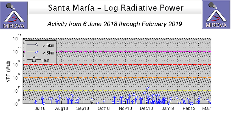 |
Figure 89. Persistent thermal activity was recorded at Santa Maria from 6 June 2018 through February 2019 as seen in the MIROVA plot of thermal energy derived from satellite thermal data. Daily explosions produced ash plumes and block avalanches that were responsible for the continued heat flow at the volcano. Courtesy of MIROVA. |
During November 2018 steam plumes rose to altitudes of 2.8-3.2 km from Caliente summit, usually drifting SW, sometimes SE. Several ash-bearing explosions were reported daily, rising to 3-3.2 km altitude and also drifting SW or SE. The highest plume reported by INSIVUMEH rose to 3.4 km on 25 November and drifted SW. The Washington VAAC reported an ash emission on 9 November that rose to 4.3 km altitude and drifted W; it dissipated within a few hours about 35 km from the summit. On 11 November another plume rose to 4.9 km altitude and drifted NW. INSIVUMEH issued a special report on 2 November noting an increase in block avalanches on the S and SE flanks, many of which traveled from the crater dome to the base of the volcano. Nearly constant avalanche blocks descended the SE flank of the dome and occasionally traveled down the other flanks as well throughout the month. They reached the bottom of the cone again on 29 November. Ashfall was reported around the flanks more than once every week and at Finca Florida on 12 November. Finca San Jose reported ashfall on 11, 13, and 23 November, and Parcelamiento Monte Claro reported ashfall on 15, 24, 25, and 27 November.
Constant degassing from the Caliente dome during December 2018 formed white plumes of mostly steam that rose to 2.6-3.0 km altitude during the month. Weak explosions averaging 9-13 per day produced gray ash plumes that rose to 2.8-3.4 km altitude. The Washington VAAC reported an ash emission on 4 December that extended 25 km SW of the summit at 3.0 km altitude and dissipated quickly. Small ash plumes were visible in satellite imagery a few kilometers WNW on 8, 12, 30, and 31 December at 4.3 km altitude; they each dissipated within a few hours. Ashfall was reported in Finca Monte Claro on 1 and 4 December, and in San Marcos Palajunoj on 26 and 30 December along with Loma Linda. On 28 December ashfall on the E flank affected the communities of Las Marías, Calahuache, and El Nuevo Palmar. Block avalanches occurred daily, sending large blocks to the base of the volcano that often stirred up small plumes of ash in the vicinity (figure 90).
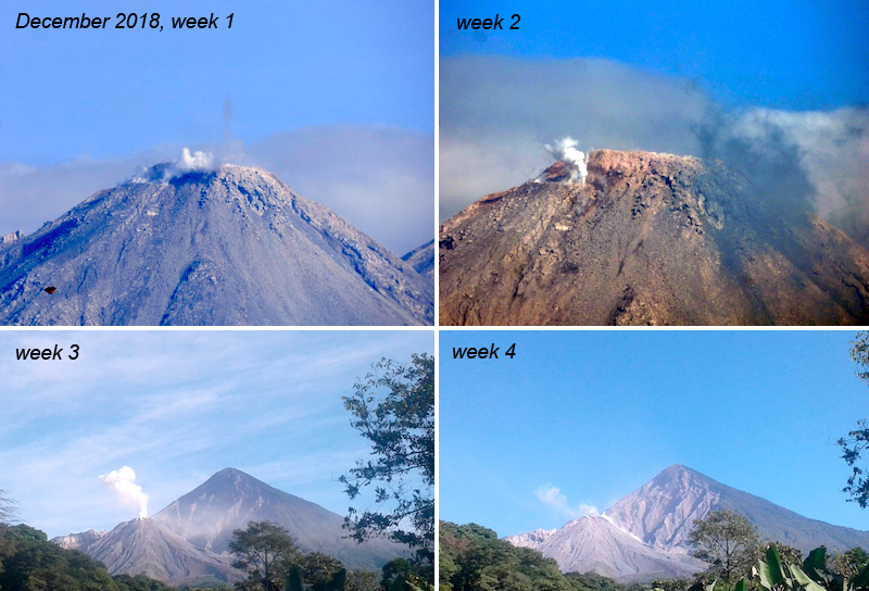 |
Figure 90. Activity during December 2018 at Santa Maria included constant degassing of steam plumes, weak explosions with ash plumes, and block avalanches rolling down the flanks to the base of the cone. Courtesy of INSIVUMEH (Reporte Semanal de Monitoreo: Volcán Santiaguito (1402-03), Diciembre 2018). |
Multiple explosions daily during January 2019 produced steam-and-ash plumes (figure 91). Constant degassing rising 10-500 m emerged from the SSE part of the Caliente dome, and ashfall, mainly on the W and SW rim of the cone, was a daily feature. Seismic station STG-3 detected 10-18 explosions per day that produced ash plumes, which rose to between 2.7 and 3.5 km altitude. The Washington VAAC noted a faint ash emission in satellite imagery on 1 January that was about 25 km W of the summit at 4.3 km altitude. A new emission appeared at the same altitude on 4 January about 15 km NW of the summit. A low-density emission around midday on 5 January produced an ash plume that drifted NNE at 4.6 km altitude. Ash plumes drifted W at 4.3 km altitude on 11 and 14 January for short periods of time before dissipating.
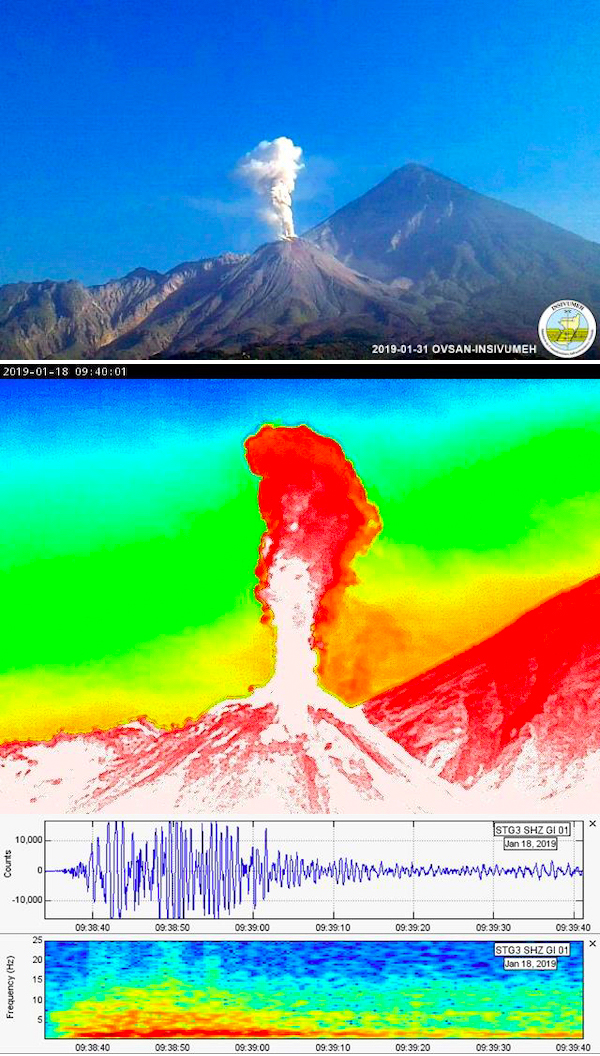 |
Figure 91. Explosions during January produced numerous steam-and-ash plumes at the Santiaguito complex of Santa Maria. A moderate explosion on 31 January 2019 produced an ash plume that rose to about 3.1 km altitude (top). A thermal image and seismograph show another moderate explosion on 18 January 2019 that also rose nearly vertically from the summit of Caliente. Courtesy of INSIVUMEH (Informe mensual de actividad Volcanica enero 2019, Volcan Santiaguito). |
Ash drifted mainly towards the W, SW, and S, causing ashfall in the villages of San Marcos Palajunoj, Loma Linda, Monte Bello, El Patrocinio, La Florida, El Faro, Patzulín and a few others several times during the month. The main places where daily ashfall was reported were near the complex, in the hilly crop areas of the El Faro and San José Patzulín farms (figure 92). Blocks up to 3 m in diameter reached the base of the complex, stirring up ash plumes that settled on the immediate flanks. Juvenile material continued to appear at the summit of the dome during January; the dome had risen above the edge of the crater created by the explosions of 2016. Changes in the size and shape of the dome between 23 November 2018 and 13 January 2019 showed the addition of material on the E and SE side of the dome, as well as a new effusive flow that travelled 200-300 m down the E flank (figure 93).
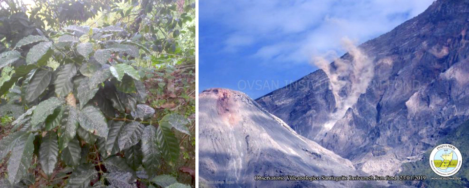 |
Figure 92. Near-daily ashfall affected the coffee plants at the El Faro and San José Patzulín farms (left) at Santiaguito during January 2019. Large avalanche blocks descending the flanks, seen here on 23 January 2018, often stirred up smaller ash plumes that settled out next to the cone. Courtesy of INSIVUMEH (Informe mensual de actividad Volcanica enero 2019, Volcan Santiaguito). |
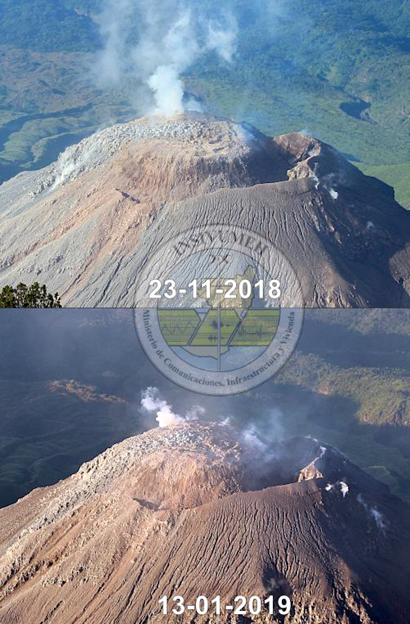 |
Figure 93. A comparison of the growth at the Caliente dome of the Santiaguito complex at Santa Maria between 23 November 2018 (top) and 13 January 2019 (bottom) shows the emergence of juvenile material and a 200-300 m long effusive flow that has moved slowly down the E flank. Courtesy of INSIVUMEH (Informe mensual de actividad Volcanica enero 2019, Volcan Santiaguito). |
Persistent steam rising 50-150 m above the crater was typical during February 2019 and accompanied weak and moderate explosions that averaged 12 per day throughout the month. White and gray ash plumes from the explosions rose to 2.8-3.3 km altitude; daily block avalanches usually reached the base of the dome (figure 94). Ashfall occurred around the complex, mainly on the W, SW, and NE flanks on a daily basis, but communities farther away were affected as well. The Washington VAAC reported an ash plume on 7 February in visible satellite imagery moving SW from the summit at 4.9 km altitude. The next day a new ash plume was located about 20 km W of the summit, dissipating rapidly, at 4.3 km altitude. Ashfall drifting SW affected Palajuno Monte Claro on 5, 9, 15, and 16 February. Ash drifting E and SE affected Calaguache, Las Marías and surrounding farms on 14 and 17 February, and fine-grained ash drifting SE was reported at finca San José on 21 February.
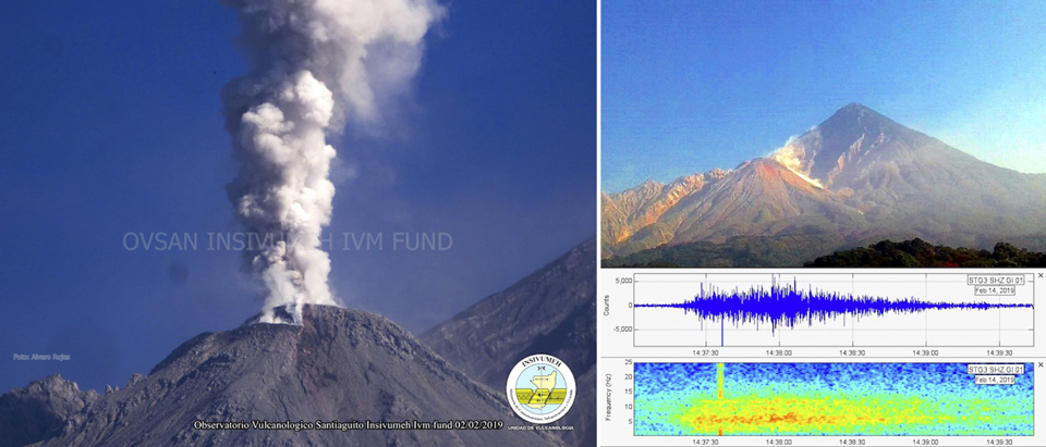 |
Figure 94. Activity at the Caliente dome of the Santiaguito complex at Santa Maria included daily ash-and-steam explosions and block avalanches descending the sides of the dome in February 2019. A typical explosion on 2 February 2019 produced an ash plume that rose to about 3 km altitude and drifted SW (left). A block avalanche on 14 February descended the SE flank and stirred up small plumes of ash in the vicinity (right, top); the avalanche lasted for 88 seconds and registered with seismic frequencies between 3.46 and 7.64 Hz (right bottom). Courtesy of INSIVUMEH (Reporte Semanal de Monitoreo: Volcán Santiaguito (1402-03), Semana del 01 al 08 de febrero de 2019). |
Information Contacts: Instituto Nacional de Sismologia, Vulcanologia, Meteorologia e Hydrologia (INSIVUMEH), Unit of Volcanology, Geologic Department of Investigation and Services, 7a Av. 14-57, Zona 13, Guatemala City, Guatemala (URL: http://www.insivumeh.gob.gt/); Washington Volcanic Ash Advisory Center (VAAC), Satellite Analysis Branch (SAB), NOAA/NESDIS OSPO, NOAA Science Center Room 401, 5200 Auth Rd, Camp Springs, MD 20746, USA (URL: www.ospo.noaa.gov/Products/atmosphere/vaac, archive at: http://www.ssd.noaa.gov/VAAC/archive.html); MIROVA (Middle InfraRed Observation of Volcanic Activity), a collaborative project between the Universities of Turin and Florence (Italy) supported by the Centre for Volcanic Risk of the Italian Civil Protection Department (URL: http://www.mirovaweb.it/).
Persistent explosions with local ashfall, March-August 2019; frequent lahars during June; increased explosions in early July
The dacitic Santiaguito lava-dome complex on the W flank of Guatemala's Santa María volcano has been growing and actively erupting since 1922. The youngest of the four vents in the complex, Caliente, has been erupting with ash explosions, pyroclastic, and lava flows for more than 40 years. A lava dome that appeared within the summit crater of Caliente in October 2016 has continued to grow, producing frequent block avalanches down the flanks. Daily explosions of steam and ash also continued during March-August 2019, the period covered in this report, with information primarily from Guatemala's INSIVUMEH (Instituto Nacional de Sismologia, Vulcanologia, Meterologia e Hidrologia) and the Washington VAAC (Volcanic Ash Advisory Center).
Activity at Santa Maria continued with little variation from previous months during March-August 2019, except for a short-lived increase in the frequency and intensity of explosions during early July that produced minor pyroclastic flows. Plumes of steam with minor magmatic gases rose continuously from both the S rim of the Caliente crater and from the summit of the growing dome throughout the period. They usually rose 100-700 m above the summit, generally drifting W or SW, and occasionally SE, before dissipating. In addition, daily explosions with varying amounts of ash rose to altitudes of around 2.8-3.5 km and usually extended no more than 25 km before dissipating. Most of the plumes drifted SW or SE; minor ashfall occurred in the adjacent hills almost daily and was reported at the fincas located within 10 km in those directions several times each month. Continued growth of the Caliente lava dome resulted in daily block avalanches descending its flanks to the base of the dome. The MIROVA plot of thermal energy during this time shows a consistent level of heat from early December 2018 through April 2019, very little activity during May and June, and a short-lived spike in activity from late June through early July that coincides with the increase in explosion rate and intensity. Activity decreased later in July and into August (figure 95).
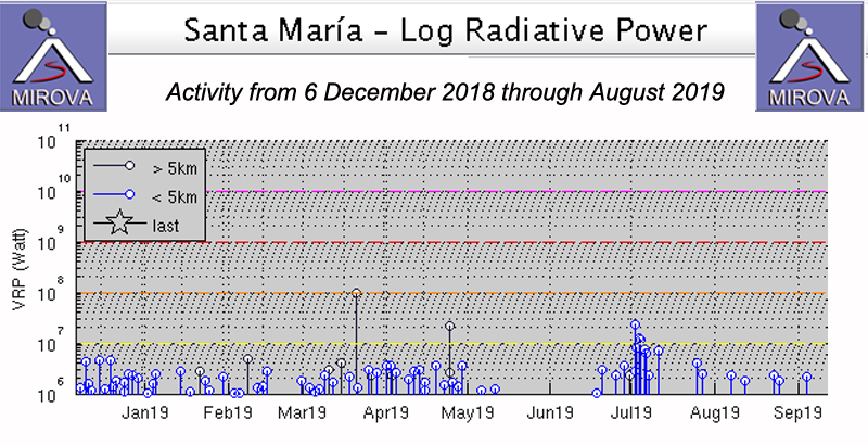 |
Figure 95. Thermal activity at Santa Maria from 8 December 2018 through August 2019 was similar to previous months. A noticeable decrease in activity occurred during May and early June 2019 with a short-lived spike during late June and early July that corresponded to an increase in explosion rate and intensity during that brief interval. Courtesy of MIROVA. |
Explosive activity increased slightly during March 2019 to 474 events from 409 events during February, averaging about 15 per day; the majority of explosions were weak to moderate in strength. The moderate explosions generated small block avalanches daily that sent debris 300 m down the flanks of Caliente dome; the explosions contained low levels of ash and large quantities of steam. Daily activity consisted mostly of degassing around the southern rim of the crater and within the central dome, with plumes rising about 100 m from the S rim, and pulsating between 100-400 m above the central dome, usually white and sometimes blue with gases; steam plumes drifted as far as 10 km. The weak ash emissions resulted in ashfall close to the volcano, primarily to the W and SW in the mountainous areas of El Faro, Patzulín, La Florida, and Monte Bello farms. During mid-March, residents of the villages of Las Marías and El Viejo Palmar, located S of the dome, reported the smell of sulfur. The seismic station STG3 registered 8-23 explosions daily that produced ash plumes which rose to altitudes between 2.7 and 3.3 km altitude. Explosions from the S rim were usually steam rich, while reddish oxidized ash was more common from the NE edge of the growing dome in the summit crater (figure 96). The constant block avalanches were generated by viscous lava slowly emerging from the growing summit dome, and also from the explosive activity. On the steep S flank of Santa Maria, blocks up to 3 m in diameter often produce small plumes of ash and debris as they fall.
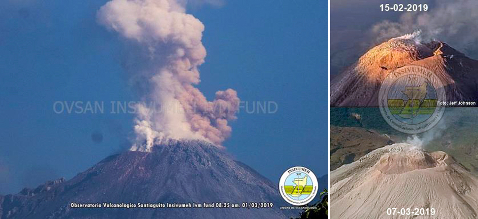 |
Figure 96. Mostly steam rose from the S rim of the Caliente dome at Santa Maria throughout March-August 2019. On 1 March 2019, oxidized reddish ash from the growing dome was also part of the emissions (left). The dome continued to grow, essentially filling the inside of the summit crater of Caliente. Courtesy of INSIVUMEH (INFORME MENSUAL DE ACTIVIDAD VOLCÁNICA MARZO 2019, VOLCÁN SANTIAGUITO). |
Late on 4 March 2019 an explosion was heard 10 km away that generated incandescence 100 m above the crater and block avalanches that descended to the base of the Caliente dome; it also resulted in ashfall around the perimeter of the volcano. Powerful block avalanches were reported in Santa María creek on 8 March. Ashfall was reported in the villages of San Marcos and Loma Linda Palajunoj on 14 March. Ash plumes on 18 March drifted W and caused ashfall in the villages of Santa María de Jesús and Calaguache. A small amount of ashfall was reported on 26 March around San Marcos Palajunoj. The Washington VAAC reported volcanic ash drifting W from the summit on 8 March at 4.6 km altitude. A small ash plume was visible in satellite imagery moving WSW on 11 March at 4.6 km altitude. On 20 March a plume was detected drifting SW at 3.9 km altitude for a short time before dissipating.
Explosion rates of 10-14 per day were typical for April 2019. Ash plumes rose to 2.7-3.2 km altitude. Block avalanches reached the base of the Caliente dome each day. Steam and gas plumes pulsated 100-400 m above the S rim of the crater (figure 97). Ashfall in the immediate vicinity of the volcano, generally on the W and SW flanks was also a daily feature. The Washington VAAC reported multiple small ash emissions on 2 April moving W and dissipating quickly at 4.9 km altitude. An ash plume from two emissions drifted WSW at 4.3 km altitude on 10 April, and on 22 April two small discrete emissions were observed in satellite images moving SE at 4.6 km altitude. Ashfall was reported on 13 and 14 April in the nearby mountains and areas around Finca San José to the SE. On 15 and 23 April, ash plumes drifted W and ashfall was reported in the area of San Marcos and Loma Lina Palajunoj.
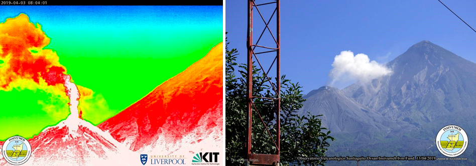 |
Figure 97. Degassing from the Caliente dome at Santa Maria on 3 April (left, infrared image) and 13 April 2019 (right) produced steam-rich plumes with minor quantities of ash. Courtesy of INSIVUMEH (Reporte Semanal de Monitoreo:, Volcán Santiaguito, Semana del 30 de marzo al 05 de abril de 2019). |
Constant degassing continued from the S rim of the crater during May 2019 while pulses of steam and gas rose 100-500 m from the dome at the center of the summit crater. Weak to moderate explosions continued at a rate of 8-12 per day. White and gray plumes of steam and ash rose 300-700 m above the crater daily. A moderate-size lahar on 16 May descended the Rio San Isisdro; it was 20 m wide and carried blocks 2 m in diameter. Ashfall was reported on the W flank around the area of San Marcos and Loma Lina Palajunoj on 21 and 24 May. INSIVIUMEH reported on 29 and 30 May that seismic station STG8 recorded moderate lahars descending the Rio San Isidro (a drainage to the Rio Tambor). The thick, pasty lahars transported blocks 1-3 m in diameter, branches, and tree trunks. They were 20 m wide and 1.5-2 m deep.
Weak to moderate explosions continued during June 2019 at a rate of 9-12 per day, producing plumes of ash and steam that rose 300-700 m above the Caliente crater. On 1 June explosions produced ashfall to the E over the areas of Calaguache, Las Marías and other nearby communities. Ash plumes commonly reached 3.0-3.3 km altitude and drifted W and SW, and block avalanches constantly descended the E and SE flanks from the dome at the top of Caliente. Ashfall was reported at the Santa María de Jesús community on 7 June. Ashfall to the W in San Marcos and Loma Linda Palajunoj was reported on 10, 15, 18, 20, and 22 June. Ashfall to the SE in Fincas Monte Claro and El Patrocinio was reported on 26 June. A few of the explosions on 28 June were heard up to 10 km away. On 29 June ash dispersed to the W again over the farms of San Marcos, Monte Claro, and El Patrocinio in the area of Palajunoj; the next day, ash was reported in Loma Linda and finca Monte Bello to the SW. The Washington VAAC reported ash emissions on 29 June that rose to 4.3 km and drifted W; two ash clouds were observed, one was 35 km from Santa Maria and the second drifted 55 km before dissipating.
With the onset of the rainy season, eight lahars were reported during June. The Rio Cabello de Ángel, a tributary of Río Nimá I (which flows into Rio Samalá) on the SE flank experienced lahars on 3, 5, 11, 12, 21, and 30 June (figure 98). The lahars were 15-20 m wide, 1-2 m deep, and carried branches, tree trunks and blocks 1-3 m in diameter. On 12 and 15 June, lahars descended the Río San Isidro on the SW flank. They were 1.5 m deep, 15-20 m wide and carried tree trunks and blocks up to 2 m in diameter.
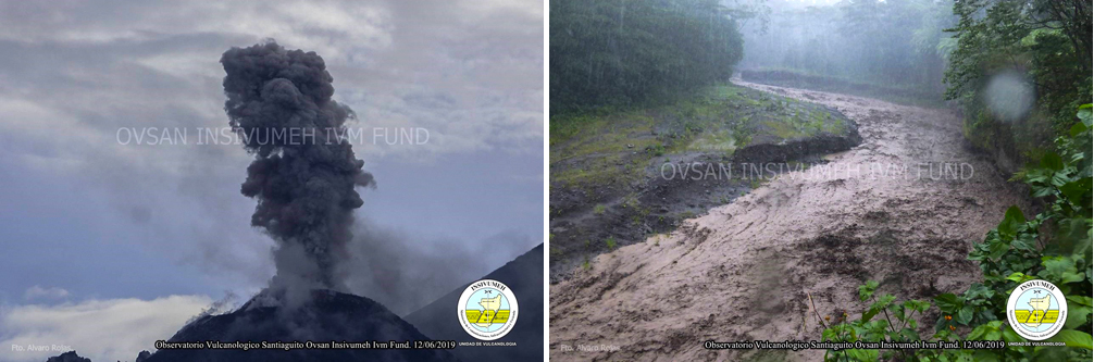 |
Figure 98. Activity at Santa Maria on 12 June 2019 included explosions with abundant ash and lahars. This lahar is in the Rio Nimá I, and started in the Rio Cabello de Ángel. Courtesy of INSIVUMEH (Reporte Semanal de Monitoreo: Volcán Santiaguito, Semana del 08 al 14 de junio de 2019). |
An increase in the frequency and intensity of seismic events was noted beginning on 28 June that lasted through 6 July 2019. Explosions occurred at a rate of 5-6 per hour, reaching 40-45 events per day instead of the 12-15 typical of previous months. Ash plumes rose to 3.5-3.8 km altitude and drifted W, SW, and S as far as 10 km, and ashfall was reported in San Marcos Palajunoj, Loma Linda villages, Monte Bello farms, El Faro, La Mosqueta, La Florida, and Monte Claro. Activity decreased after 7 July back to similar levels of the previous months. As a result of the increased activity during the first week of July, several small pyroclastic flows (also known as pyroclastic density currents or PDC's) were generated that traveled up to 1 km down the S, SE, and E flanks during 2-5 and 13 July, in addition to the constant block avalanches from the dome extrusion and explosions (figure 99). As activity levels decreased after 6 July, the ash plume heights lowered to 3.3 km altitude, while pulsating degassing continued from the summit dome, rising 100-500 m.
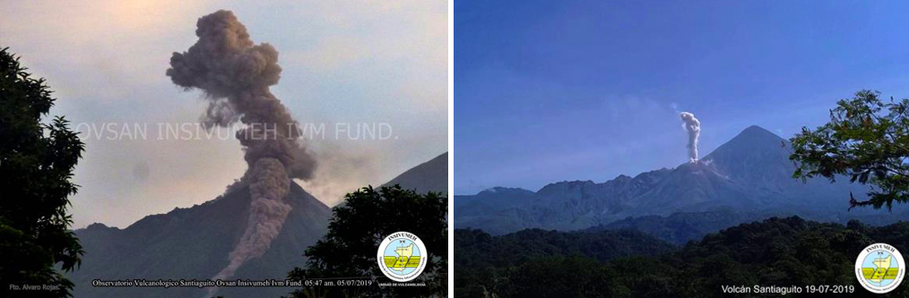 |
Figure 99. An increase in explosive activity at Santa Maria during the first week of July 2019 resulted in several small pyroclastic flows descending the flanks, including one on 3 July 2019 (left). An ash emission on 19 July 2019 rose above the nearby summit of Santa Maria (right). Courtesy of INSIVUMEH (INFORME MENSUAL DE ACTIVIDAD VOLCÁNICA JULIO 2019, VOLCÁN SANTIAGUITO). |
The Washington VAAC reported an ash plume on 2 July from a series of emissions that rose to 3.9 km altitude and drifted W. Satellite imagery on 4 July showed a puff of ash moving W from the summit at 4.3 km altitude. The next day an ash emission was observed in satellite imagery moving W at 4.9 km altitude. A plume on 11 July drifted W at 4.3 km for several hours before dissipating. Ashfall was reported on 2 July at the San Marcos farm and in the villages of Monte Claro and El Patrocinio in the Palajunoj area. On 4 and 6 July ash fell to the SW and W in San Marcos and Loma Linda Palajunoj. On 5 July there were reports of ashfall in Monte Claro and areas around San Marcos Palajunoj and some explosions were heard 5 km away. In Monte Claro to the SW ash fell on 7 July and sounds were heard 5 km away every three minutes. Incandescence was observed in the early morning on the SE and NE flanks of the dome. During 8 and 9 July, four to eight weak explosions per hour were noted and ash dispersed SW, especially over Monte Claro; pulsating degassing noises were heard every two minutes. Monte Bello and Loma Linda reported ashfall on 12, 16, 17, 19, and 20 July. On 15, 22, 26, and 29 July ash was reported in San Marcos and Loma Linda Palajunoj; 33 explosions occurred on 25 July. Two lahars were reported on 8 July. A strong one in the Rio San Isidro was more than 2 m deep, and 20-25 m wide with blocks as large as 3 m in diameter. A more moderate lahar affected Rio Cabello de Angel and was also 2 m deep. It was 15-20 m wide and had blocks 1-2 m in diameter.
Activity declined further during August 2019. Constant degassing continued from the S rim of the crater, but only occasional pulses of steam and gas rose from the central dome. Weak to moderate explosions occurred at a rate of 15-20 per day. White and gray plumes with small amounts of ash rose 300-800 m above the summit daily. Block avalanches descended to the base of the dome and sent fine ash particles down the SE and S flanks. Ashfall was common within 5 km of the summit, generally on the SW flank, near Monte Bello farm, Loma Linda village and San Marcos Palajunoj. Explosions rates decreased to 10-11 per day during the last week of the month. Degassing and ash plumes rose to 2.9-3.2 km altitude throughout the month.
On 1 August ash plumes drifted 10-15 km SW, causing ashfall in that direction. On 3 and 27 August ashfall occurred at Monte Claro and El Patrocinio in the Palajunoj area to the SW. On 7 and 31 August ashfall was reported in Monte Claro. San Marcos and Loma Linda Palajunoj reported ash on 11, 16, 19, and 23 August. On 21 August ashfall was reported to the SE around Finca San José. The Washington VAAC reported an ash plume visible in satellite imagery on 10 August 2019 drifting W at 4.3 km altitude a few kilometers from the summit which dissipated quickly. On 27 August a plume was observed 25 km W of the summit at 3.9 km altitude, dissipating rapidly. On 3 August a moderate lahar descended the Rio Cabello de Ángel that was 1 m deep, 15 m wide and carried blocks up to 1 m in diameter along with branches and tree trunks. A large lahar on 20 August descended Río Cabello de Ángel; it was 2-3 m high, 15 m wide and carried blocks 1-2 m diameter, causing erosion along the flanks of the drainage (figure 100).
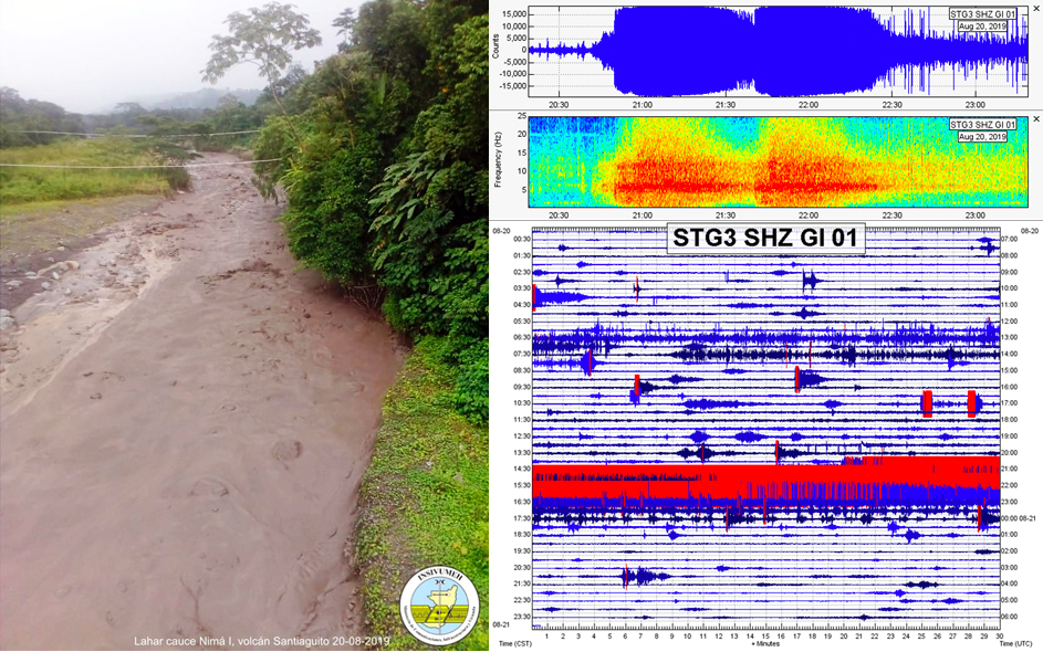 |
Figure 100. A substantial lahar at Santa Maria on 20 August 2019 sent debris down the Río Cabello de Ángel in the vicinity of El Viejo Palmar (left), the spectrogram of the seismic signal lasted for 2 hours and 16 minutes (top right), and the seismograph was saturated with the lahar signal in red (bottom right). Courtesy of INSIVUMEH (Reporte Semanal de Monitoreo: Volcán Santiaguito, Semana del 17 al 23 de agosto de 2019). |
Information Contacts: Instituto Nacional de Sismologia, Vulcanologia, Meteorologia e Hydrologia (INSIVUMEH), Unit of Volcanology, Geologic Department of Investigation and Services, 7a Av. 14-57, Zona 13, Guatemala City, Guatemala (URL: http://www.insivumeh.gob.gt/); MIROVA (Middle InfraRed Observation of Volcanic Activity), a collaborative project between the Universities of Turin and Florence (Italy) supported by the Centre for Volcanic Risk of the Italian Civil Protection Department (URL: http://www.mirovaweb.it/); Washington Volcanic Ash Advisory Center (VAAC), Satellite Analysis Branch (SAB), NOAA/NESDIS OSPO, NOAA Science Center Room 401, 5200 Auth Rd, Camp Springs, MD 20746, USA (URL: www.ospo.noaa.gov/Products/atmosphere/vaac, archive at: http://www.ssd.noaa.gov/VAAC/archive.html).
Daily explosions with ash plumes and block avalanches continue, September 2019-February 2020
The dacitic Santiaguito lava-dome complex on the W flank of Guatemala's Santa María volcano has been growing and actively erupting since 1922. Ash explosions, pyroclastic, and lava flows have emerged from Caliente, the youngest of the four vents in the complex, for more than 40 years. A lava dome that appeared within the summit crater of Caliente in October 2016 has continued to grow, producing frequent block avalanches down the flanks. Daily explosions with ash plumes and block avalanches continued during September 2019-February 2020, the period covered in this report, with information primarily from Guatemala's INSIVUMEH (Instituto Nacional de Sismologia, Vulcanologia, Meterologia e Hidrologia) and the Washington VAAC (Volcanic Ash Advisory Center).
Constant fumarolic activity with steam and gas persisted from the Caliente dome throughout September 2019-February 2020. Explosions occurred multiple times per day, producing ash plumes that rose to altitudes of 3.1-3.5 km and usually drifted a few kilometers before dissipating. Several lahars during September and October carried volcanic blocks, ash, and debris down major drainages. Periodic ashfall was reported in communities within 10 km of the volcano. An increase in thermal activity beginning in November (figure 101) resulted in an increased number of observations of incandescence visible at night from the summit of Caliente through February 2020. Block avalanches occurred daily on the flanks of the dome, often reaching the base, stirring up small clouds of ash that drifted downwind.
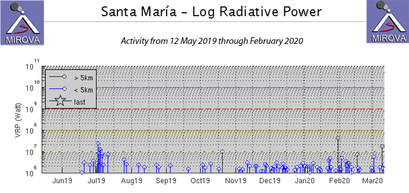 |
Figure 101. The MIROVA project graph of thermal activity at Santa María from 12 May 2019 through February 2020 shows a gradual increase in thermal energy beginning in November 2019. This corresponds to an increase in the number of daily observations of incandescence at the summit of the Caliente dome during this period. Courtesy of MIROVA. |
Constant steam and gas fumarolic activity rose from the Caliente dome, drifting W, usually rising to 2.8-3.0 km altitude during September 2019. Multiple daily explosions with ash plumes rising to 2.9-3.4 km altitude drifted W or SW over the communities of San Marcos, Loma Linda Palajunoj, and Monte Claro (figure 102). Constant block avalanches fell to the base of the cone on the NE and SE flanks. The Washington VAAC reported an ash plume visible in satellite imagery on 10 September at 3.1 km altitude drifting W. On 14 September another plume was spotted moving WSW at 4.6 km altitude which dissipated quickly; the webcam captured another plume on 16 September. Ashfall on 27 September reached about 1 km from the volcano; it reached 1.5 km on 29 September. Lahars descended the Rio Cabello de Ángel on 2 and 24 September (figure 102). They were about 15 m wide, and 1-3 m deep, carrying blocks 1-2 m in diameter.
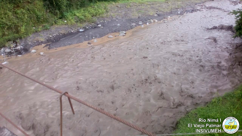 |
Figure 102. A lahar descended the Rio Cabello de Ángel at Santa Maria and flowed into the Rio Nima 1 on 24 September 2019. Courtesy of INSIVUMEH (Reporte Semanal de Monitoreo: Volcán Santiaguito (1402-03), Semana del 21 al 27 de septiembre de 2019). |
Througout October 2019, degassing of steam with minor gases occurred from the Caliente summit, rising to 2.9-3.0 km altitude and generally drifting SW. Weak explosions took place 1-5 times per hour, producing ash plumes that rose to 3.2-3.5 km altitude. Ashfall was reported in Monte Claro on 2 October. Nearly constant block avalanches descended the SE and S flanks, disturbing recent layers of fine ash and producing local ash clouds. Moderate explosions on 11 October produced ash plumes that rose to 3.5 km altitude and drifted W and SW about 1.5 km towards Río San Isidro (figure 103). The following day additional plumes drifted a similar distance to the SE. The Washington VAAC reported an ash emission visible in satellite imagery at 4.9 km altitude on 13 October drifting NNW. Ashfall was reported in Parcelamiento Monte Claro on 14 October. Some of the block avalanches observed on 14 October on the SE, S, and SW flanks were incandescent. Ash drifted 1.5 km W and SW on 17 October. Ashfall was reported near la finca Monte Claro on 25 and 28 October. A lahar descended the Río San Isidro, a tributary of the Río El Tambor on 7 October carrying blocks 1-2 m in diameter, tree trunks, and branches. It was about 16 m wide and 1-2 m deep. Additional lahars descended the rio Cabello de Angel on 23 and 24 October. They were about 15 m wide and 2 m deep, and carried ash and blocks 1-2 m in diameter, tree trunks, and branches.
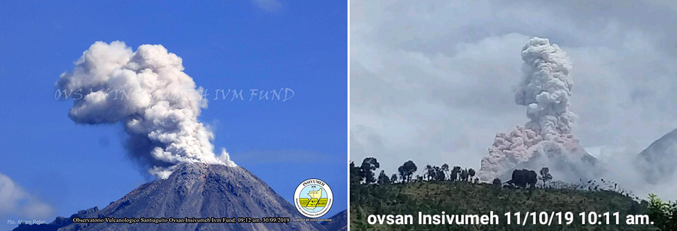 |
Figure 103. Daily ash plumes were reported from the Caliente cone at Santa María during October 2019, similar to these from 30 September (left) and 11 October 2019 (right). Courtesy of INSIVUMEH (Reporte Semanal de Monitoreo: Volcán Santiaguito (1402-03), Semana del 28 de septiembre al 04 de octubre de 2019; Reporte Semanal de Monitoreo: Volcán Santiaguito (1402-03), Semana del 05 al 11 de octubre de 2019). |
During November 2019, steam plumes rose to 2.9-3.0 km altitude and generally drifted E. There were 1-3 explosions per hour; the ash plumes produced rose to altitudes of 3.1-3.5 km and often drifted SW, resulting in ashfall around the volcanic complex. Block avalanches descended the S and SW flanks every day. On 4 November ashfall was reported in the fincas (ranches) of El Faro, Santa Marta, El Viejo Palmar, and Las Marías, and the odor of sulfur was reported 10 km S. Incandescence was observed at the Caliente dome during the night of 5-6 November. Ash fell again in El Viejo Palmar, fincas La Florida, El Faro, and Santa Marta (5-6 km SW) on 7 November. Sulfur odor was also reported 8-10 km S on 16, 19, and 22 November. Fine-grained ash fell on 18 November in Loma Linda and San Marcos Palajunoj. On 29 November strong block avalanches descended in the SW flank, stirring up reddish ash that had fallen on the flanks (figure 104). The ash drifted up to 20 km SW.
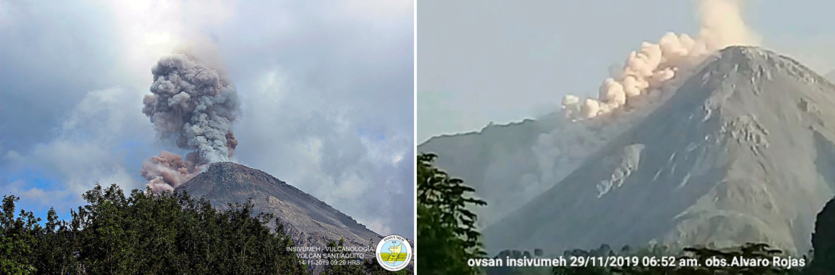 |
Figure 104. Ash plumes rose from explosions multiple times per day at Santa Maria’s Santiaguito complex during November 2019, and block avalanches stirred up reddish clouds of ash that drifted for many kilometers. Courtesy of INSIVUMEH. Left, 11 November 2019, from Reporte Semanal de Monitoreo: Volcán Santiaguito (1402-03), Semana del 09 al 15 de noviembre de 2019. Right, 29 November 2019 from BOLETÍN VULCANOLÓGICO ESPECIAL BESTG# 106-2019, Guatemala 29 de noviembre de 2019, 10:50 horas (Hora Local). |
White steam plumes rising to 2.9-3.0 km altitude drifted SE most days during December 2019. One to three explosions per hour produced ash plumes that rose to 3.1-3.5 km altitude and drifted W and SW producing ashfall on the flanks. Several strong block avalanches sent material down the SW flank. Ash from the explosions drifted about 1.5 km SW on 3 and 7 December. The Washington VAAC reported a small ash emission that rose to 4.9 km altitude and drifted WSW on 8 December, and another on 13 December that rose to 4.3 km altitude. Ashfall was reported up to 10 km S on 24 December. Incandescence was reported at the dome by INSIVUMEH eight times during the month, significantly more than during the recent previous months (figure 105).
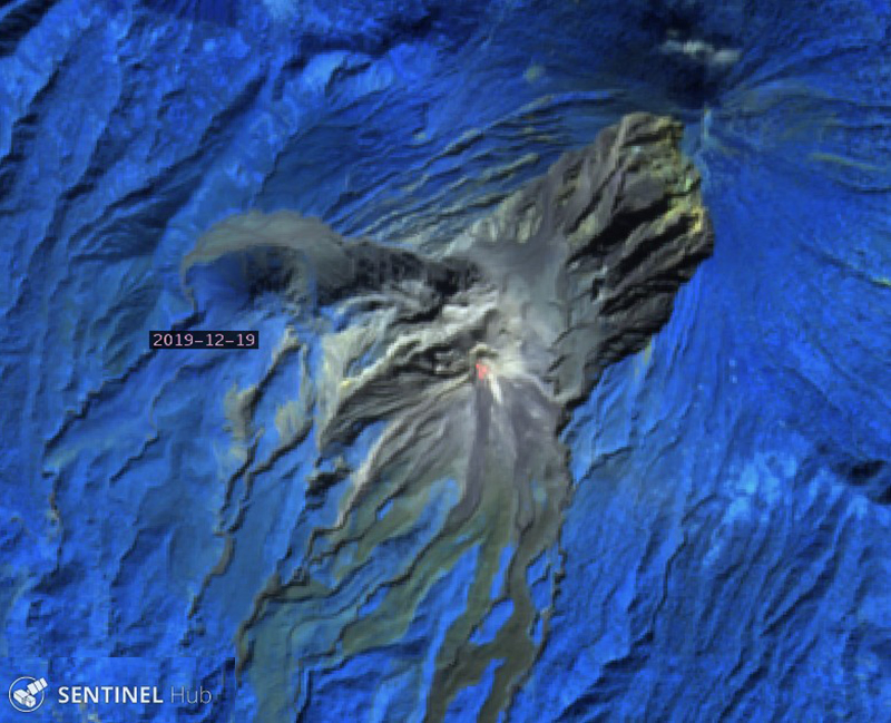 |
Figure 105. Strong thermal anomalies were visible in Sentinel-2 imagery at the summit of the Caliente cone at Santa María’s Santiaguito’s complex on 19 December 2019. Image uses Atmospheric Penetration rendering (bands 12, 11, 8A). Courtesy of Sentinel Hub Playground. |
Activity during January 2020 was similar to that during previous months. White plumes of steam rose from the Caliente dome to altitudes of 2.7-3.0 km and drifted SE; one to three explosions per hour produced ash plumes that rose to 3.2-3.4 km altitude and generally drifted about 1.5 km SW before dissipating. Frequent block avalanches on the SE flank caused smaller plumes that drifted SSW often over the ranches of San Marcos and Loma Linda Palajunoj. On 28 January ash plumes drifted W and SW over the communities of Calaguache, El Nuevo Palmar, and Las Marías. In addition to incandescence observed at the crater of Caliente dome at least nine times, thermal anomalies in satellite imagery were detected multiple times from the block avalanches on the S flank (figure 106).
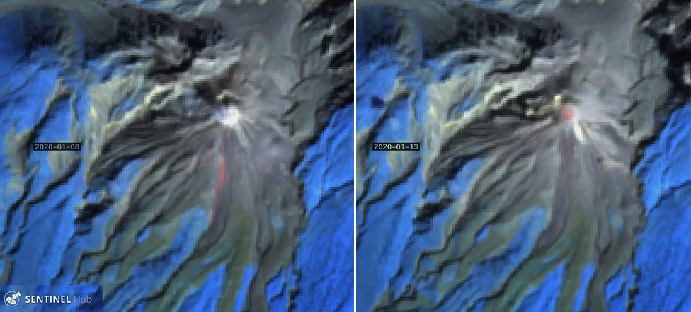 |
Figure 106. Incandescence at the summit and in the block avalanches on the S flank of the Caliente cone at Santa María’s Santiaguito’s complex was visible in Sentinel-2 satellite imagery on 8 and 13 January 2020. Atmospheric penetration rendering images (bands 12, 11, 8A) courtesy of Sentinel Hub Playground. |
The Washington VAAC reported an ash plume visible in satellite imagery at 4.6 km altitude drifting W on 3 February 2020. INSIVUMEH reported constant steam degassing that rose to 2.9-3.0 km altitude and drifted SW. In addition, 1-3 weak to moderate explosions per hour produced ash plumes to 3.1-3.5 km altitude that drifted about 1 km SW. Small amounts of ashfall around the volcano’s perimeter was common. The ash plumes on 5 February drifted NE over Santa María de Jesús. On 8 February the ash plumes drifted E and SE over the communities of Calaguache, El Nuevo Palmar, and Las Marías. Block avalanches on the S and SE flanks of Caliente dome continued, creating small ash clouds on the flank. Incandescence continued frequently at the crater and was also observed on the S flank in satellite imagery (figure 107).
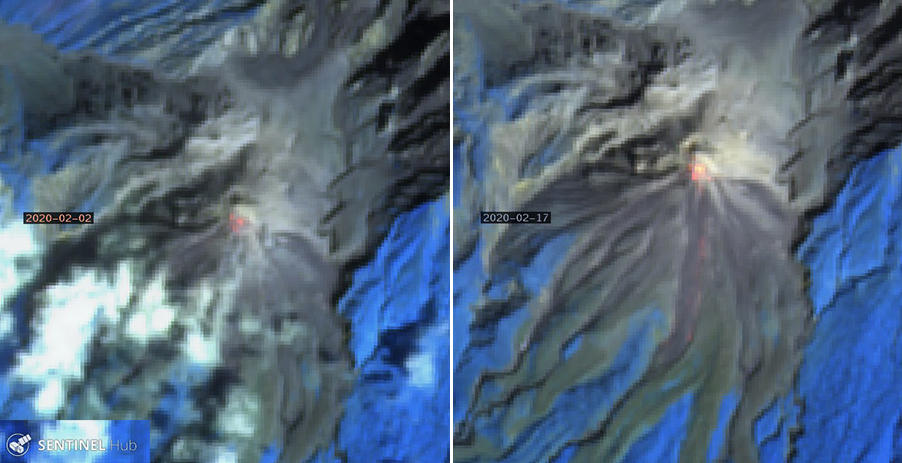 |
Figure 107. Incandescence at the summit and on the S flank of the Caliente cone at Santa María’s Santiaguito’s complex was frequent during February 2020, including on 2 (left) and 17 (right) February 2020 as seen in Sentinel-2 imagery. Atmostpheric Penetration rendering imagery (bands 12, 11, 8A) courtesy of Sentinel Hub Playground. |
Information Contacts: Instituto Nacional de Sismologia, Vulcanologia, Meteorologia e Hydrologia (INSIVUMEH), Unit of Volcanology, Geologic Department of Investigation and Services, 7a Av. 14-57, Zona 13, Guatemala City, Guatemala (URL: http://www.insivumeh.gob.gt/ ); Washington Volcanic Ash Advisory Center (VAAC), Satellite Analysis Branch (SAB), NOAA/NESDIS OSPO, NOAA Science Center Room 401, 5200 Auth Rd, Camp Springs, MD 20746, USA (URL: www.ospo.noaa.gov/Products/atmosphere/vaac, archive at: http://www.ssd.noaa.gov/VAAC/archive.html); Sentinel Hub Playground (URL: https://www.sentinel-hub.com/explore/sentinel-playground); MIROVA (Middle InfraRed Observation of Volcanic Activity), a collaborative project between the Universities of Turin and Florence (Italy) supported by the Centre for Volcanic Risk of the Italian Civil Protection Department (URL: http://www.mirovaweb.it/).
Daily explosions with ash plumes, block avalanches, and pyroclastic flows during March-July 2020
Santa María is a stratovolcano located in Guatemala, which includes the Santiaguito lava-dome complex on the W flank. The youngest and more recently active of the four vents is the Caliente cone, characterized by explosions, ash plumes, pyroclastic flows, and lahars (BGVN 45:04). A lava dome appeared in the summit crater of Caliente in October 2016 and has continued to grow. The Caliente vent is at about 2.5 km elevation, and the summit of the volcano is around 3.7 km elevation. Daily explosions, ash plumes, ashfall, and block avalanches continued during this reporting period of March-July 2020 with information primarily from INSIVUMEH (Instituto Nacional de Sismologia, Vulcanologia, Meterologia e Hidrologia), the Washington VAAC (Volcanic Ash Advisory Center), and various satellite data.
Constant white gas-and-steam emissions from the Caliente dome reached 2.8-3.4 km altitude throughout March-July 2020. Multiple explosions were registered each day, many of which were accompanied by ash plumes rising to 3-3.7 km altitude and drifting in multiple directions up to 15 km from the Caliente dome. Block avalanches, ash plumes, and a few weak to moderate pyroclastic flows were prominent during this reporting period, according to INSIVUMEH. Intermittent incandescence was also observed in the Caliente dome. Occasional ashfall was observed in nearby communities.
During March, the STG3 seismic station registered weak to moderate explosions that produced ash plumes rising to 3.5 km altitude drifting in multiple directions as far as 1.5 km from the Caliente dome. The explosions also generated weak to moderate block avalanches along the S, E, SE, and SW flanks on the Caliente dome. Occasional incandescence in the Caliente crater was observed at night. Some ashfall was reported in the villages of Loma Linda, San Marcos, and Palajunoj on 5, 8, 13-14, 16, 20, and 28-29 March, and the mountainous areas of Monte Carlo on 30 March.
Explosions continued in April (figure 108), producing ash plumes up to 3.5 km altitude drifting in multiple directions as far as 1.2 km. Constant block avalanches were reported on the S, E, SE, and SW flanks of the Caliente dome, occasionally accompanied by incandescence. Intermittent ashfall was reported in the villages of Loma Linda and San Marcos during the month, including fine ashfall on the volcanic perimeter. On 21 April weak explosions produced an ash plume rising 3.4 km altitude drifting W and SW, resulting in ashfall in Loma Linda and San Marcos and block avalanches on the S, E, and SE flanks (figure 109). On 24 April fine ashfall was also reported in Finca La Florida (5 km S) and Santa Marta (5-6 km SW).
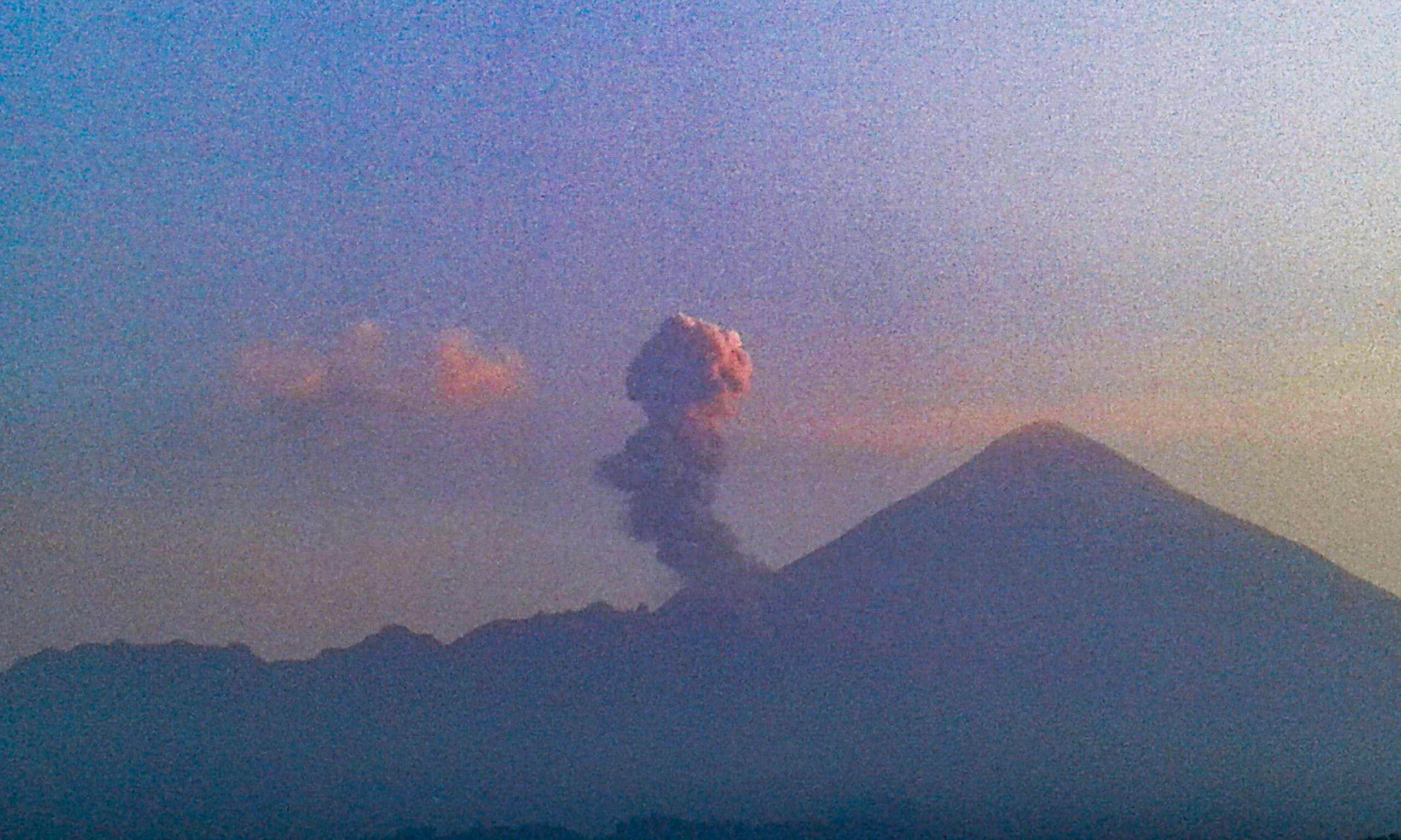 |
Figure 108. Image of an ash plume rising from the Caliente cone at Santa María during April 2020. Image has been color enhanced. Courtesy of INSIVUMEH (Fotografías Recientes de Volcanes). |
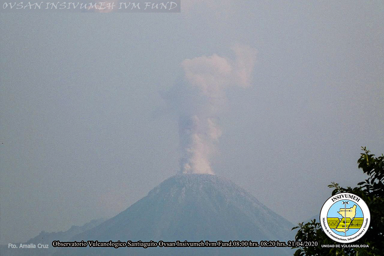 |
Figure 109. Webcam image of an ash plume rising from the Caliente cone at Santa María during 21 April 2020. Courtesy of INSIVUMEH (Fotografías Recientes de Volcanes). |
During May, continuous explosions produced ash plumes up to 3.5 km altitude drifting in multiple directions as far as 1 km from the Caliente dome. Constant weak and moderate block avalanches were observed on the S, SW, and SE flanks of the Caliente dome accompanied by some fine ashfall on the volcanic perimeter and white gas-and-steam emissions that rose 3.1 km altitude. On 7 and 17 May heavy rain on the upper part of the volcanic complex generated lahars that carried ash and blocks up to 1-2 m in diameter. Incandescence was intermittently observed at night.
Explosions from the Caliente dome in June were accompanied by ash plumes typically rising to 3.5 km altitude and drifting in different directions up to 1 km. Intermittent fine ashfall was reported around the volcanic; ashfall was also observed in the areas of Finca San José on 3 June, Loma Linda on 20 June, and Monte Carlo and surrounding areas on 22 June. Heavy rain on the upper part of the volcanic complex on 8 June generated lahars that carried ash and blocks up to 1-2 m in diameter. During the early morning on 9 June explosions produced an ash plume that rose to a maximum altitude of 3.7 km that drifted S and SW as far as 12-15 km from the Caliente dome. Weak and moderate pyroclastic flows and block avalanches on the S, SW, and SE flanks were also generated from these explosions. An explosion at 0535 on 19 June produced an ash plume that rose 3.5 km altitude and a small pyroclastic flow on the SW flank that reached the base of the Caliente dome. Incandescent pulses were visible at night and during the early morning on 19, 24, and 29 June. A Washington VAAC notice on 25 June reported a small ash plume drifting WNW, but it was not visible in satellite imagery. White gas-and-steam emissions continued rising to 3.4 km altitude while occasional incandescence was observed in the Caliente dome and on the S and SE flanks during the night and early morning.
Activity during July was similar to that of previous months. White gas-and-steam plumes continued to rise from the Caliente dome to 3.2 km altitude. STG3 seismic station registered weak to moderate explosions produced ash plumes up to 3.5 km altitude, resulting in occasional fine ashfall on the volcanic perimeter, in the villages of San Marcos and Loma Linda, Palajunoj on 20 and 30 July, and over Palajunoj and Fca Patrocinio on 25 July. Moderate to strong block avalanches were detected on the S, SW, and SE flanks. Incandescence at night was observed on most nights and during the early morning in the Caliente dome; incandescent pulses were reported on 4 July, according to INSIVUMEH. On 10-11 July the STG3 seismic station registered weak and moderate explosions that produced ash plumes up to 3-3.4 km altitude drifting W up to 12 km from the Caliente dome. Small pyroclastic flows and block avalanches on the W and NW flanks accompanied the explosions, resulting in ashfall in the villages of San Marcos and Loma Linda Palajunoj (figure 110). On 21 July weak and moderate explosions produced ash plumes up to 3.4 km altitude, resulting in slight ashfall on the volcanic perimeter, and moderate to strong avalanches on the S, SW, and SE flanks, some of which were accompanied by pyroclastic flows. During 25-26 and 31 July moderate and strong block avalanches on the W, NW, S, SW, and SE flanks were accompanied by pyroclastic flows.
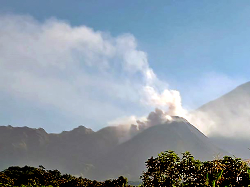 |
Figure 110. Webcam image of white gas-and-steam emissions and a pyroclastic flow originating from the Caliente cone at Santa María during 9 July 2020. Courtesy of INSIVUMEH (BOLETÍN VULCANOLÓGICO ESPECIAL BESAN #43-2020 del 09 de Julio de 2020). |
MIROVA (Middle InfraRed Observation of Volcanic Activity) analysis of MODIS satellite data detected frequent thermal anomalies during March to mid-April 2020; after May the frequency and power of these anomalies decreased, but continued through July (figure 111). Some of these thermal anomalies were observed in Sentinel-2 thermal satellite imagery, originating from the summit of the Caliente cone (figure 112).
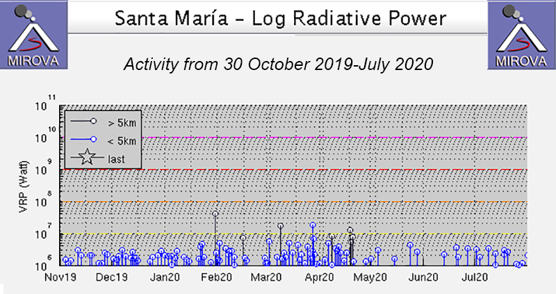 |
Figure 111. Thermal anomalies at Santa María from 30 October 2019 through July 2020 as recorded by the MIROVA system (Log Radiative Power) were slightly stronger and more frequent during March to mid-April. By May, the power and number of detected thermal anomalies decreased, but continued through July. Courtesy of MIROVA. |
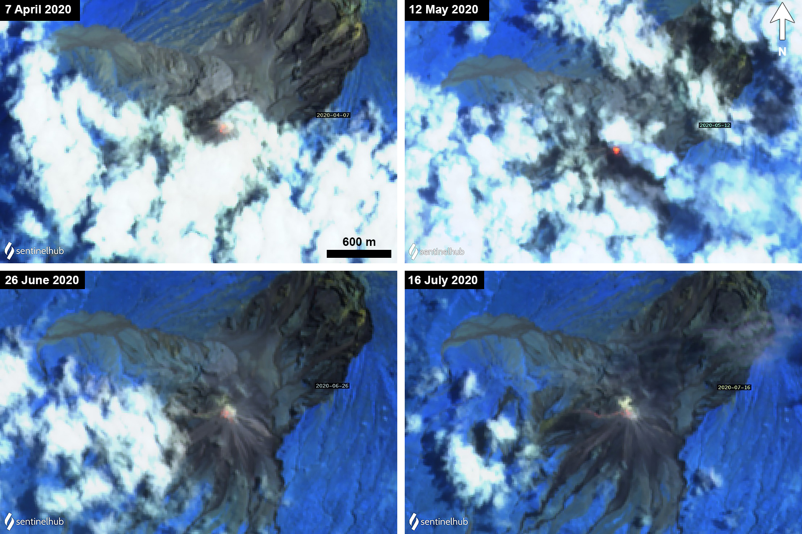 |
Figure 112. Sentinel-2 thermal satellite imagery (bands 12, 11, 8A) showed strong thermal anomalies visible at the summit of the Caliente cone at Santa Maria’s Santiaguito’s complex on 7 April (top left), 12 May (top right), 26 June (bottom left) and 16 July (bottom right) 2020. Courtesy of Sentinel Hub Playground. |
Information Contacts: Instituto Nacional de Sismologia, Vulcanologia, Meteorologia e Hydrologia (INSIVUMEH), Unit of Volcanology, Geologic Department of Investigation and Services, 7a Av. 14-57, Zona 13, Guatemala City, Guatemala (URL: http://www.insivumeh.gob.gt/ ); MIROVA (Middle InfraRed Observation of Volcanic Activity), a collaborative project between the Universities of Turin and Florence (Italy) supported by the Centre for Volcanic Risk of the Italian Civil Protection Department (URL: http://www.mirovaweb.it/); Sentinel Hub Playground (URL: https://www.sentinel-hub.com/explore/sentinel-playground); Washington Volcanic Ash Advisory Center (VAAC), Satellite Analysis Branch (SAB), NOAA/NESDIS OSPO, NOAA Science Center Room 401, 5200 Auth Rd, Camp Springs, MD 20746, USA (URL: www.ospo.noaa.gov/Products/atmosphere/vaac, archive at: http://www.ssd.noaa.gov/VAAC/archive.html).
Frequent explosions and avalanches August 2020-January 2021; lava extrusion in September 2020
Santa Maria is one of the most active volcanoes in Guatemala. Major features are the Santa Maria edifice with the large crater that formed in the 1902 eruption, and the Santiaguito dome complex about 2.5 km down the SW flank that includes the currently active Caliente dome (figure 113). Activity typically includes ash plumes, gas emissions, lava extrusion, and avalanches. This report summarizes activity during August 2020 through January 2021 and is based on reports by Instituto Nacional de Sismología, Vulcanología, Meteorología e Hidrología (INSIVUMEH), Coordinadora Nacional para la Reducción de Desastres (CONRED), and satellite data.
 |
Figure 113. Main features of the Santa Maria complex are shown in this March 2021 Planet Labs satellite image monthly mosaic. The large scarp is the wall of the crater produced during the 1902 eruption. Within that the El Brujo, El Monje, La Mitad domes, and the currently active Caliente dome, are from W to E. Courtesy of Planet Labs. |
Throughout August weak to moderate explosions were reported most days, some days occurring 2-4 times per hour. These produced ash plumes to an altitude of 3.5 km, typically reaching 3.4 km. The plumes were dispersed mostly W and SW, sometimes S, SE, and NW. Degassing was reported throughout the month, with plumes reaching 3.5 km, but most often 3-3.1 km altitude. On the 3rd, ashfall was reported in San Marcos Palajuno (8 km SW), Loma Linda (6 km WSW) and others in that direction, and again on the 29th. It was also reported in Monte Claro (S of the summit) on the 12th and light ashfall occurred on the flanks through the month. Explosions on the 23rd produced weak pyroclastic flows that traveled down the SW flank of the dome. The activity produced frequent avalanches on the S, SW, and SE flanks of the dome, some reaching the base of the dome and some depositing fine ash onto the flanks. The sound of explosions and degassing were reported most days and incandescence was frequently seen at the crater at night.
This activity continued through September, maintaining the same eruptive pattern of weak and moderate explosions, gas emission, lava extrusion, and avalanches. Incandescence continued to be visible at the crater. There was ashfall reported in Monte Claro, Aldea San Marcos Palajunoj and other surrounding communities on the 7th, Monte Claro on the 11th, and across the Palajunoj area on the 28th. On the afternoon of 25 September lahars occurred in the Cabello de Ángel and Nimá I drainages. Lava extrusion was reported on the morning of the 29th along with resulting block-and-ash flows.
Throughout October explosions, gas emission, avalanches, and elevated crater temperatures producing nighttime incandescence (figure 114) continued in the same manner as the previous months. From the 9th the extrusion of lava was observed over the dome, generating block-and-ash flows mainly down the W flank. Ashfall was reported in of Loma Linda and El Rosario Palajunoj and others in the area on the 13th, 7 km SW on the 18th, and in San Marcos Palajunoj and nearby areas on the 23rd. Lava extrusion generated constant avalanches down multiple flanks from the 23rd, with some producing small ash plumes as they descended.
 |
Figure 114. This Shortwave Infrared (SWIR) image of Santa Maria acquired on 19 October by the Landsat 8 satellite shows elevated temperatures at the Caliente dome. The contour intervals are 30 m. Courtesy of USGS and INSIVUMEH. |
Throughout November gas emissions and explosions continued to produce gas-and-steam and ash plumes that rose up to 3.4 km altitude. Lava extrusion also continued down the W flank, producing incandescence and frequent avalanches down the SE, S, SW, and W flanks, as well as less frequent block-and-ash flows (figure 115). An increase in thermal energy detected towards the end of the month resulted from this extrusion (figure 116). Ashfall occurred around the volcano from explosions and avalanches. Ashfall was reported SE within the villages of Las Marías, Calaguache and others nearby on the 12th and 22nd, and SSW over the village of San Marcos Palajunoj, Loma Linda and Fincas in the Palajunoj area on the 27th. Degassing and explosions were intermittently heard in nearby communities with reports of sounds similar to an airplane turbine. An explosion on the 16th produced an ash plume up to 3.6 km altitude and pyroclastic flows down the flanks (figure 117).
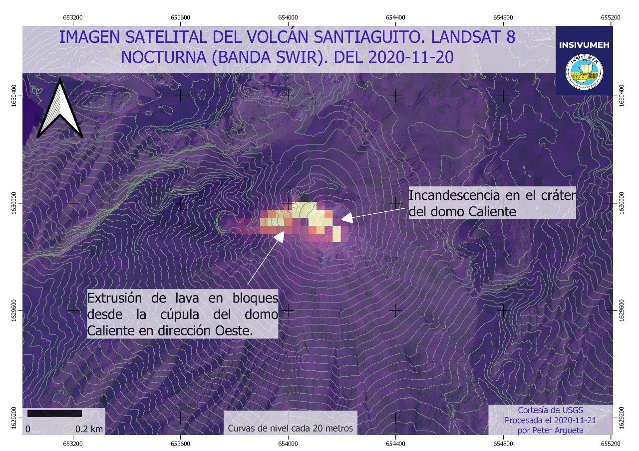 |
Figure 115. This nighttime Landsat 8 Shortwave Infrared (SWIR) satellite image of Santa Maria with the contours of the Caliente dome overlain was acquired on 20 November 2020. There are elevated temperatures within the summit crater and lava is flowing down a channel on the western flank. The contour intervals are 20 m. Courtesy of USGS and INSIVUMEH. |
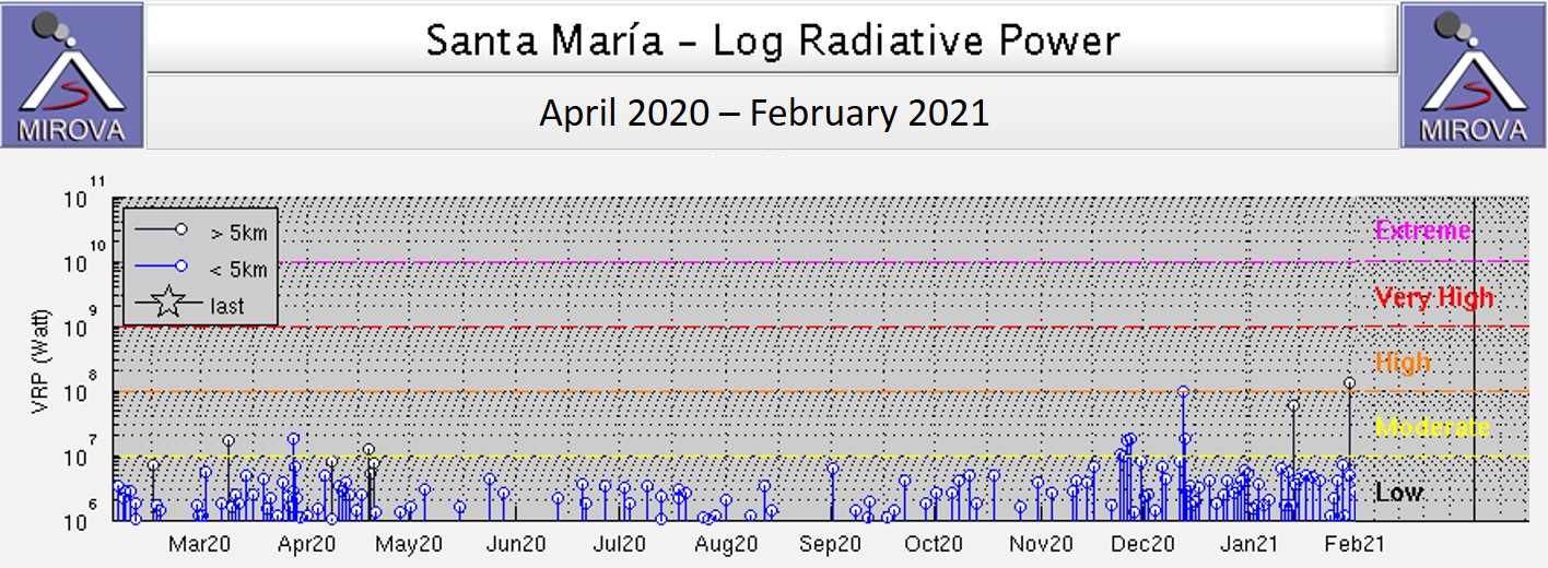 |
Figure 116. This MIROVA log radiative power plot shows the thermal energy released at Santa Maria between April 2020 to February 2021. There was a decrease in energy emitted from May to November, followed by an increase in the frequency and the energy released on some days. The black vertical lines like the two in January-February are more than 5 km from the summit and are likely not a result of volcanic activity. Courtesy of MIROVA. |
 |
Figure 117. An explosion from the Caliente dome of Santa Maria is seen here at 0715 on 16 November 2020. The photo shows the ash plume that rose to 3.6 km altitude and pyroclastic flows descending the flanks. The seismogram shows the explosion in the center of the bottom line (the times on the left are given in UTC). Courtesy of INSIVUMEH. |
Gas emissions and weak to moderate explosions continued throughout December, producing plumes reaching 3.4 km altitude along with ongoing lava extrusion producing avalanches (figures 118 and 119). Ash from explosions and avalanches was intermittently emplaced onto the flanks, and ashfall was reported in the villages of San Marcos and Loma Linda Palajunoj on the 7th, and in Loma Linda and Finca Montebello on the 11th. Activity increased from 0430 on 11 December 2020 with the generation of moderate to powerful avalanches as well as block-and-ash flows from lava extrusion and accumulation, with 13 events recorded between that time and when a report was released at 0900. The intensity continued with block-and-ash flows and pyroclastic flows moving down the W and SW flanks that generated ash plumes which extended 20 km downwind.
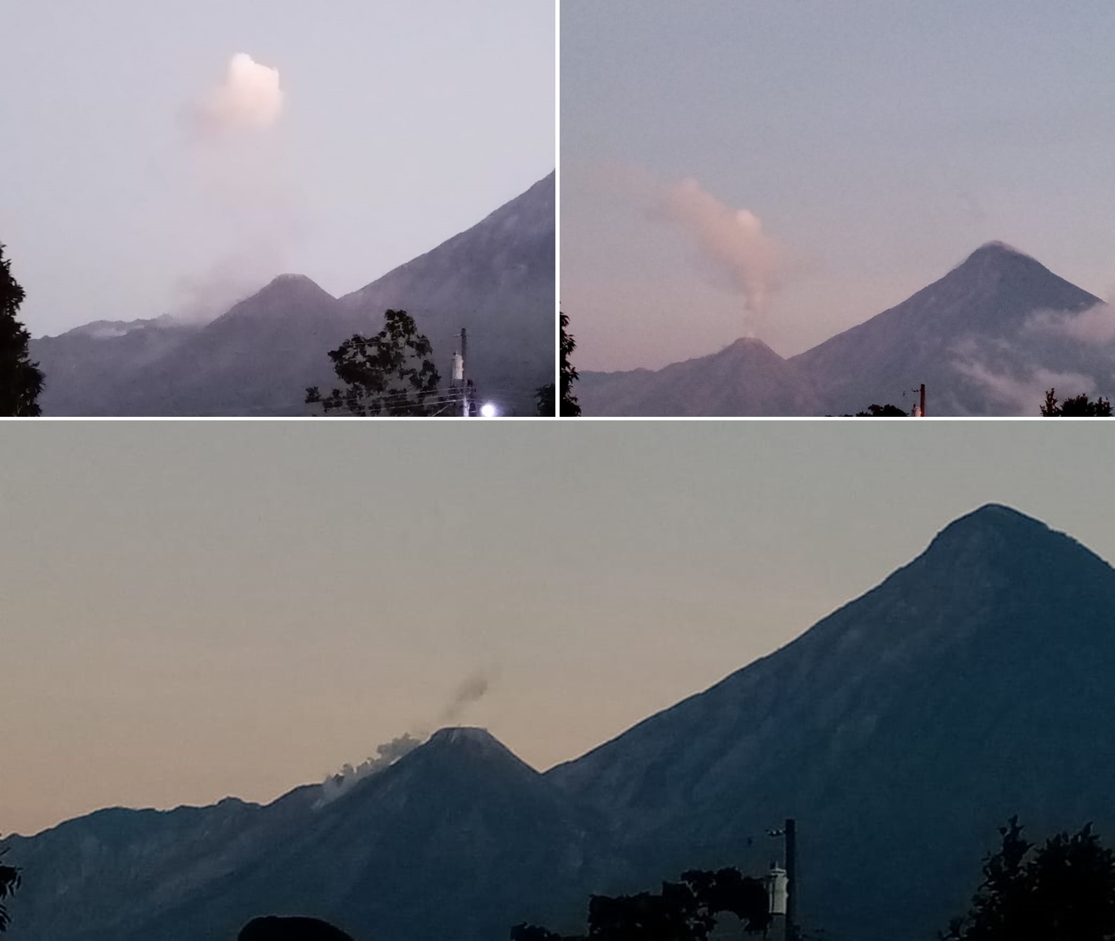 |
Figure 118. Plumes rise from the Caliente dome at Santa Maria on 9 (top left) and 15 (top right) December 2020. A faint plume rises from the summit of the Caliente dome and another plume rises from a possible avalanche down the SW flank (bottom). Courtesy of INSIVUMEH (Fotografías Recientes de Volcanes). |
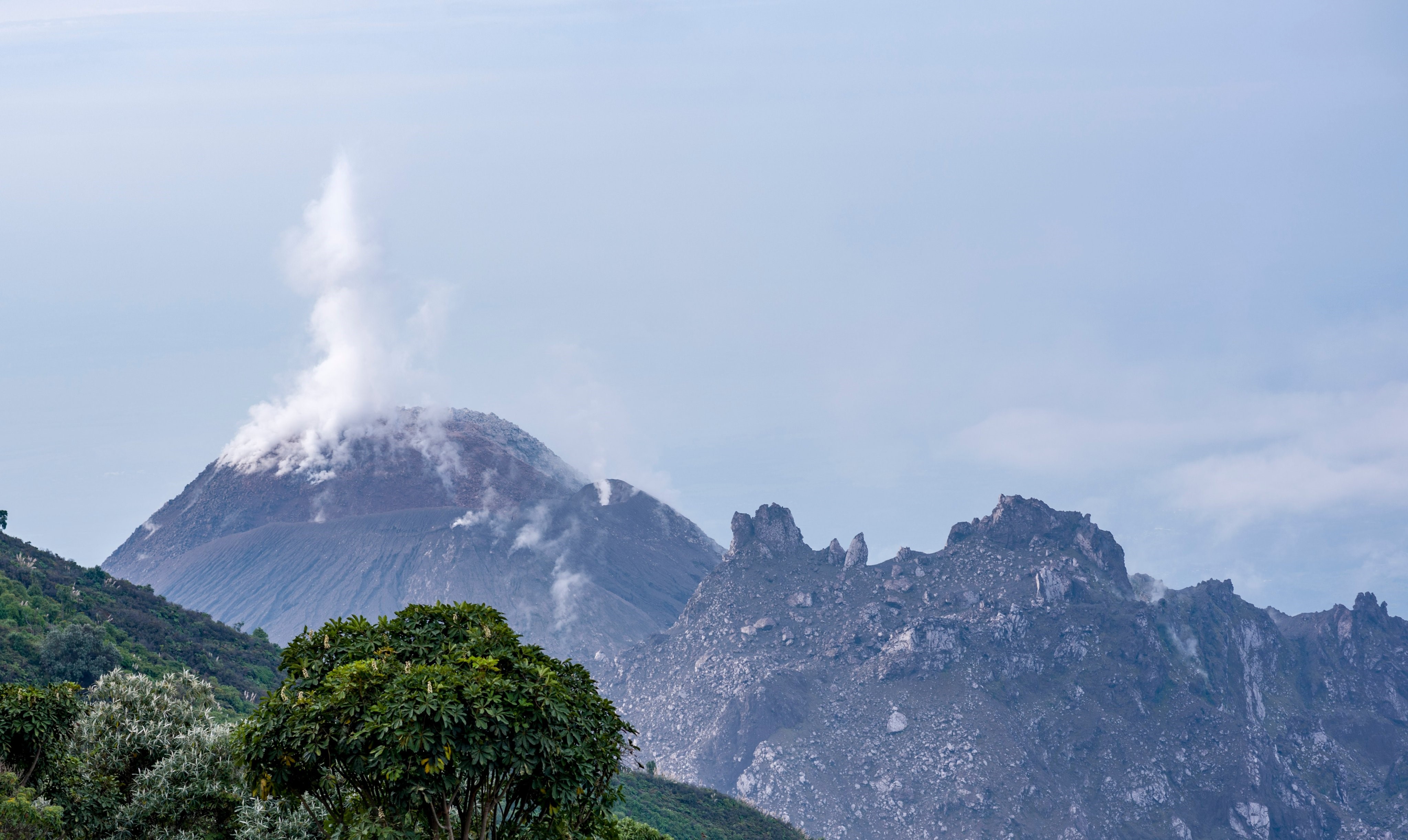 |
Figure 119. A gas-and-steam plume rises from the degassing Caliente dome at Santa Maria on 30 December 2020. Around this time weak and moderate explosions produced ash plumes up to 3-3.4 km altitude, resulting in ashfall on the flanks. Courtesy of CONRED. |
The high level of background activity associated with lava extrusion continued through January. Satellite images show the lava flow advancing down the W-flank channel (figure 120), reaching approximately 250 m by the 11th. Avalanches also continued, producing ash that was emplaced nearby (figure 121). On the 22nd the collapse of dome material produced a pyroclastic flow to the E and SE. Explosions ejected ash to 3.4 km altitude, with ashfall that was reported in the Aldeas de San Marcos and Loma Linda Palajunoj on the 1st, Aldeas de San Marcos and Loma Linda Palajunoj on the 11th, Aldeas de San Marcos y Loma Linda Palajunoj, Fca. El Patrocinio during the 20-21st. Ashfall was again reported on the 31st to the west on farms, in Aldeas de San Marcos, and in Loma Linda Palajunoj. Sounds generated by explosions were sometimes heard around 10 km away.
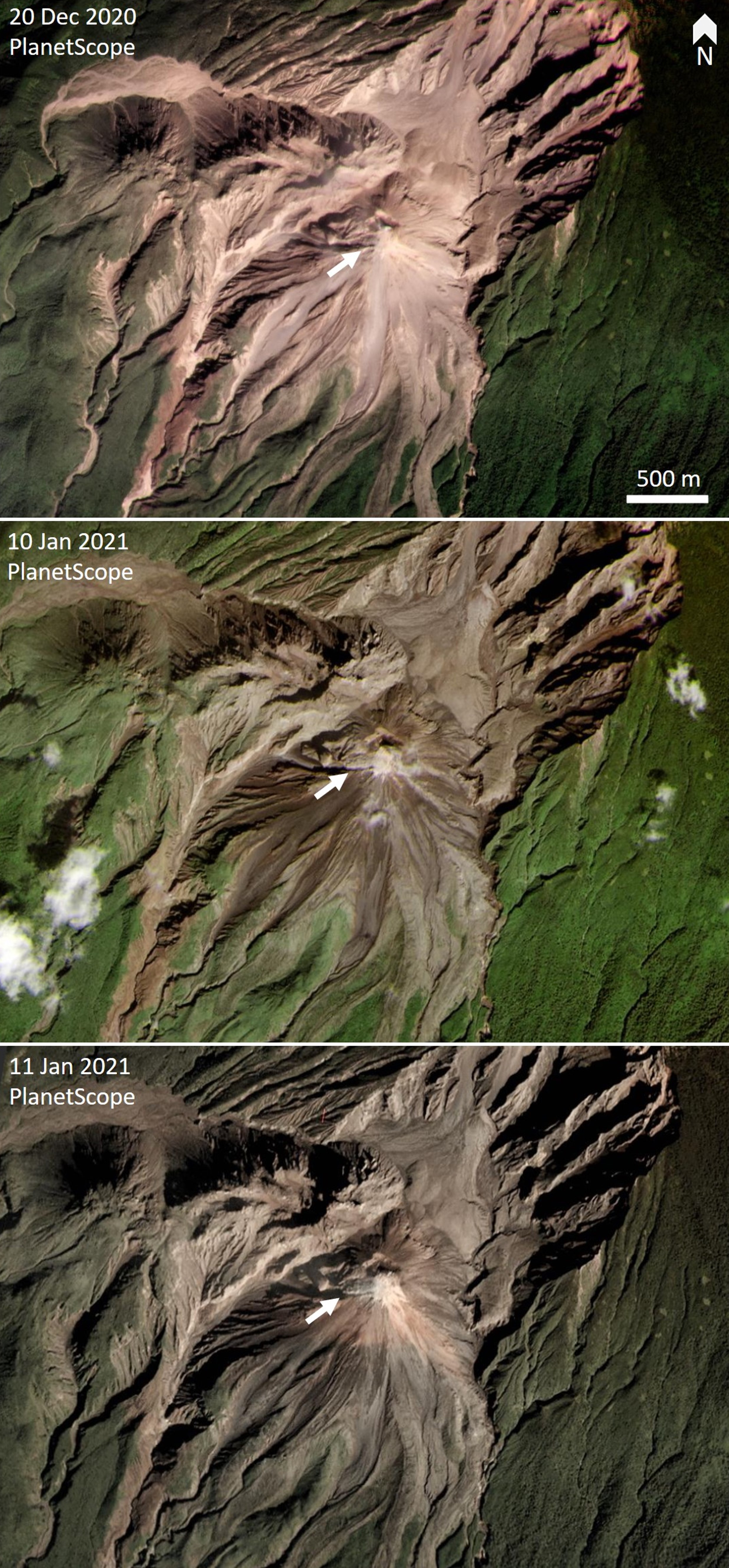 |
Figure 120. PlanetScope satellite images of Santa Maria acquired on 20 December 2020 and 10 and 11 January 2021 show the development of a lava flow down a channel on the W flank (white arrows). In the latest image the flow is approximately 250 m long. Courtesy of Planet Labs. |
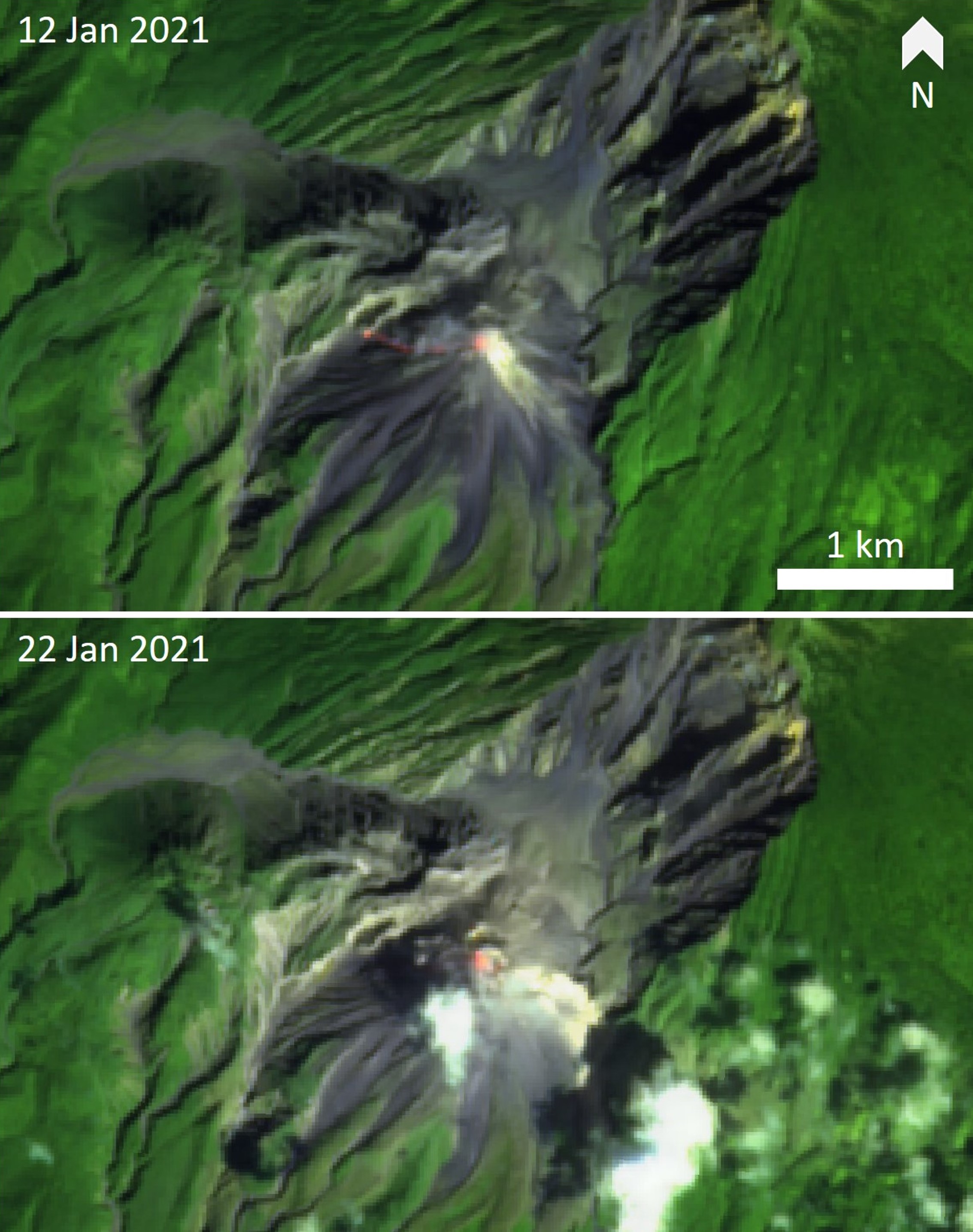 |
Figure 121. Thermal infrared satellite images of Santa Maria acquired on 12 and 22 January 2021 show higher temperatures on the Caliente dome. Top: Elevated thermal areas are detected at the summit and hot material is emplaced down the W-flank channel. Bottom: Elevated temperatures at the summit of the lava dome, with a possible avalanche on the E flank. Sentinel-2 thermal satellite images with false color (urban) (bands 12, 11, 4) rendering. Courtesy of Sentinel Hub Playground. |
Information Contacts: Instituto Nacional de Sismologia, Vulcanologia, Meteorologia e Hydrologia (INSIVUMEH), Unit of Volcanology, Geologic Department of Investigation and Services, 7a Av. 14-57, Zona 13, Guatemala City, Guatemala (URL: http://www.insivumeh.gob.gt/); Coordinadora Nacional para la Reducción de Desastres (CONRED), Av. Hincapié 21-72, Zona 13, Guatemala City, Guatemala (URL: http://conred.gob.gt/www/index.php); MIROVA (Middle InfraRed Observation of Volcanic Activity), a collaborative project between the Universities of Turin and Florence (Italy) supported by the Centre for Volcanic Risk of the Italian Civil Protection Department (URL: http://www.mirovaweb.it/); Planet Labs, Inc. (URL: https://www.planet.com/); Sentinel Hub Playground (URL: https://www.sentinel-hub.com/explore/sentinel-playground).
Blocky lava extrusion continues daily during February-July 2021
The dacitic Santiaguito lava-dome complex of Guatemala's Santa María volcano has been actively erupting since 1922. It formed within a large crater on the SW flank which was created during the VEI 6 1902 eruption. Ash explosions, pyroclastic, and lava flows have emerged from Caliente, the youngest of the four vents in the complex, for more than 40 years. The Caliente vent is at about 2.5 km elevation, and the summit of Santa Maria is around 3.7 km elevation. A lava dome that appeared within the summit crater of Caliente in October 2016 has continued to grow, producing frequent block avalanches down the flanks. Daily explosions with ash plumes and block avalanches continued during February-July 2021, the period covered in this report, with information primarily from Guatemala's INSIVUMEH (Instituto Nacional de Sismologia, Vulcanologia, Meterologia e Hidrologia).
Blocky lava extrusion from the active dome inside the summit crater of Caliente persisted throughout February-July 2021. This resulted in ongoing block avalanches and ash that descended primarily the W and SW flanks of Caliente, and occasionally the S and SE flanks. Material frequently reached the base and resulted in fine-grained ashfall and suspended ash around the perimeter. Near-constant degassing of water vapor and magmatic gases occasionally contained small amounts of ash; plumes rose to 3.0-3.2 km altitude (up to 700 m above the summit of Caliente) and drifted in multiple directions. Sounds similar to a turbine engine from the constant degassing were reported on most days. Explosions with gas and ash occurred almost daily; the plumes rose to 3.0-3.6 km altitude, and a few drifted up to 10-15 km, producing ashfall in nearby communities before dissipating. Thermal activity remained constant through May, dropped off in June, and returned to typical levels in July 2021 (figure 122).
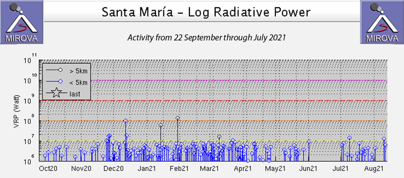 |
Figure 122. Steady levels of thermal activity persisted at Santa Maria from December 2020 through May 2021 as seen in the graph of Log Radiative Power produced by the MIROVA project from 22 September 2020 through July 2021. Activity declined in June and returned to typical levels in July 2021. Courtesy of MIROVA. |
Ashfall was reported in El Faro (7 km SSW), Aldea Las Marias (10 km S), and El Viejo Palmar (10 km S) on 5 February 2021. The next day a small pyroclastic flow was reported early in the morning on the W flank. The Washington VAAC reported an ash emission that rose to 4.6 km altitude on 7 February. It was seen moving WSW and extending approximately 15 km from the summit before dissipating later in the day. This was the only VAAC report issued for the reporting period. In a special bulletin that day INSIVUMEH noted pyroclastic flows on the SW flank that reached the head of the Rio San Isidro drainage (figure 123). They also reported ash moving SW reaching Finca Montebello, Loma Linda (7 km SW), and San Marcos Palajunoj (8 km SW). On 10 February ashfall was reported in Palajunoj. A thermal anomaly seen in Sentinel-2 satellite imagery extended down the W flank on 16 February (figure 124), likely from either incandescent blocks or a pyroclastic flow. A strong sulfur odor was noted in the area around Las Marias on 20 February. Weak pyroclastic flows affected the E and W flanks of the Caliente on 22 February; ash plumes drifted 2.5 km SW on 26 February.
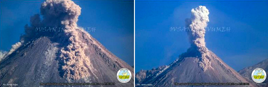 |
Figure 123. Explosions produced ash plumes and pyroclastic flows at the Caliente vent of Santa Maria on 7 February 2021. Courtesy of INSIVUMEH (Special Bulletin BESAN-007-2021, 7 February 2021). |
 |
Figure 124. A linear thermal anomaly was apparent on the W flank of the Caliente dome at Santa Maria on 16 February 2021. It was likely due to either incandescent blocks or a pyroclastic flow. Image uses Atmospheric penetration rendering (bands 12, 11, 8a). Courtesy of Sentinel Hub Playground. |
The loud noises from constant degassing were heard in El Palmar on 4 March 2021; ash plumes that day drifted up to 2 km SW. Thermal anomalies appeared in satellite data inside the summit crater of Caliente on 8 and 23 March. Explosions with ash on 9 March rose to 3.0 km altitude and drifted S and SW (figure 125). On 22 March ashfall was reported in Aldea Las Maria, Calaguache, and other nearby communities. Ashfall was reported on 25 and 27 March in Aldeas San Marcos and Loma Linda Palajunoj.
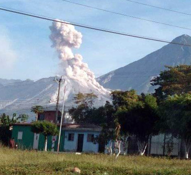 |
Figure 125. An explosion at the Caliente dome of Santa Maria’s Santiaguito complex on 9 March 2021 rose to 3 km altitude and drifted S and SW Photograph by Lluis Lopez, taken from El Palmar, Quetzaltenango, courtesy of Stereo100Noticias. |
Ash plume heights were slightly higher during April 2021, reaching 3.5 or 3.6 km altitude on most days, especially during the second half of the month. Resuspended ash from debris descending the flanks of Caliente dome produced ashfall in Viejo Palmar on 2 April. Sentinel-2 satellite imagery showed a thermal anomaly inside the summit crater that day as well. On 6 April ash plumes drifted 2.5 km SW before dissipating. On 13 and 16 April ashfall was reported in Aldeas San Marcos, Loma Linda Palajunoj, and other nearby communities. INSIVUMEH released a Special Bulletin on 18 April about a lahar that descended Rio San Isidro, carrying branches, tree trunks, volcanic ash, and blocks 1-2 m in diameter.
Ashfall was reported on 1, 6, 11, 16, 21, 26, and 31 May 2021 in Aldeas San Marcos, Loma Linda Palajunoj and other nearby communities from frequent ash plumes that rose to 3.4-3.6 km altitude and drifted SW (figure 126). Increased rainfall resulted in lahars reported on 15, 16, 24, and 30 May. The lahars on 15 and 16 May descended the Rio Cabello de Angel drainage. Branches, trunks, and volcanic blocks 1-3 m in diameter caused vibrations as they passed the seismic stations on 15 May; the next day the flow was a 25-m-wide and 1 m high pasty slurry of sulfur-smelling material full of ash and blocks from 30 cm to 1 m in diameter. The lahar on 24 May descended Rio Tambor and Rio San Isidro with tree trunks, branches, volcanic ash, and blocks 1-2 m in diameter. On 30 May heavy precipitation produced a lahar in Rio San Isidro that occurred near the Finca Filadelfia as a pasty mixture of water, blocks up to 1 m in diameter, and fine sediment, along with branches and tree trunks. A thermal anomaly was present in satellite imagery inside the summit crater on 27 May.
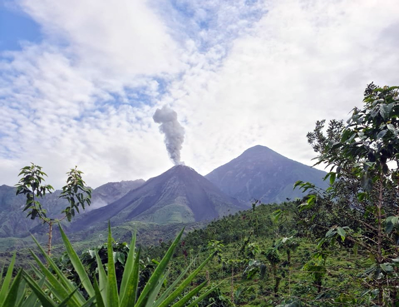 |
Figure 126. Weak explosions of ash on 31 May 2021 rose to 2.8 km altitude, drifted 5 km SW, and fine-grained ash fell in San Marcos and Loma Linda. Courtesy of CONRED . |
The ash explosions reported on 5 June 2021 rose to 2.8 km altitude and drifted 7 km SW resulting in ashfall in Aldeas San Marcos and Loma Linda Palajunoj. Ashfall was reported in the mountainous areas of Monte Claro on 8 June from plumes that reached 3.6 km altitude and drifted W and SW. On 12 and 13 June lahars descended the Rio Nima 1 (figure 127). Rio Cabello de Angel and Nima 1 were the sites of lahars on 15 June where fine-grained material and blocks 30 cm to 1 m in diameter moved down the drainages in a 1-m-deep and 20-m-wide slurry. On 15 June ashfall was reported in Calaguache and Santa Maria de Jesus (5 km SE), and on 20 and 25 June it was again reported in Loma Linda and San Marcos Palajunoj. Another lahar descended Rio Cabello de Angel and Nima 1 on 29 June after rainfall on the upper parts of the volcano. Thermal anomalies were present in Sentinel-2 satellite images inside the summit crater of Caliente on 11 and 26 June.
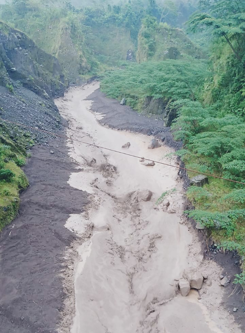 |
Figure 127. On 12 June 2021 a lahar of mud and debris descended the Nimá 1 river channel near Finca El Faro. Photo by Edgar Cabrera from COLRED at Finca El Faro, El Palmar, Quetzaltenango. Courtesy of Rony Veliz. |
During July 2021 incandescence around the summit crater of Caliente was reported more frequently than during the previous months. The constant block avalanches continued from the extruding lava primarily on the W, SW, and S flanks with some blocks reaching the base and producing ash plumes. On 5, 10, 15, 20, and 30 July ash plumes from explosions drifted 8-12 km W and SW and caused ashfall in Loma Linda and San Marcos (figure 128). The extrusion of blocky lava from the crater was reported as a 600-700 m long flow on the W flank on 10, 15, and 25 July. A lahar on 14 July in the El Tambor ravine was a pasty mixture of water, blocks up to 3 m in diameter, and fine sediments that produced seismic vibrations. Sulfur odors occurred in Las Marias on 20 and 25 July. Thermal anomalies at the summit were recorded in satellite images on 6, 16, and 31 July.
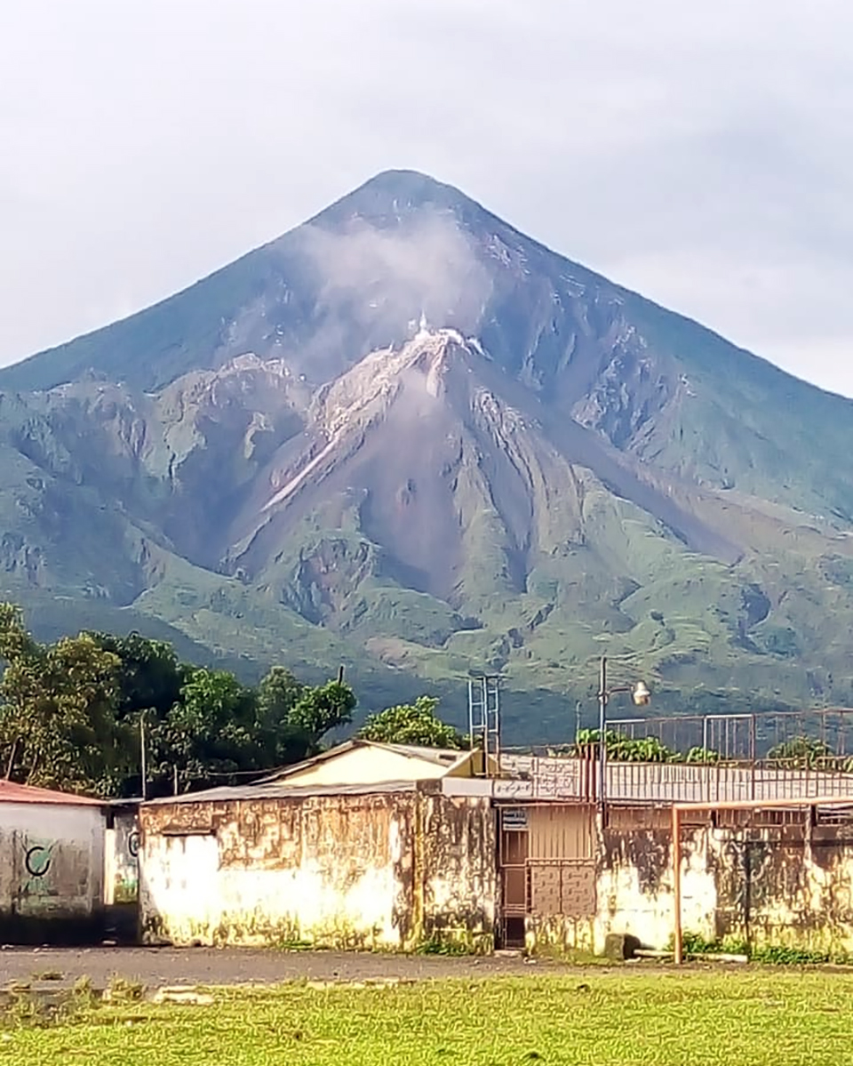 |
Figure 128. Norma Cardona of COLRED San Marcos Palajunoj El Palmar Quetzaltenango, reported that on 5 July 2021 the Caliente dome of Santiaguito was weakly degassing with minor ash drifting W. Ashfall was reported in communities to the SW that day. Courtesy of Frídel Mejicanos. |
Information Contacts: Instituto Nacional de Sismologia, Vulcanologia, Meteorologia e Hydrologia (INSIVUMEH), Unit of Volcanology, Geologic Department of Investigation and Services, 7a Av. 14-57, Zona 13, Guatemala City, Guatemala (URL: http://www.insivumeh.gob.gt/); MIROVA (Middle InfraRed Observation of Volcanic Activity), a collaborative project between the Universities of Turin and Florence (Italy) supported by the Centre for Volcanic Risk of the Italian Civil Protection Department (URL: http://www.mirovaweb.it/); Sentinel Hub Playground (URL: https://www.sentinel-hub.com/explore/sentinel-playground); Washington Volcanic Ash Advisory Center (VAAC), Satellite Analysis Branch (SAB), NOAA/NESDIS OSPO, NOAA Science Center Room 401, 5200 Auth Rd, Camp Springs, MD 20746, USA (URL: www.ospo.noaa.gov/Products/atmosphere/vaac, archive at: http://www.ssd.noaa.gov/VAAC/archive.html); CONRED, Coordinadora Nacional para la reduccion de desastres (URL: https://conred.gob.gt/, https://twitter.com/ConredGuatemala/status/1399369155544076295 ); Stereo100Noticias (URL: https://twitter.com/stereo100xela/status/1369295245272363014); Rony Veliz (URL: https://twitter.com/ronyveliz692/status/1403836189841494019); Frídel Mejicanos (URL: https://twitter.com/FridelMejicanos/status/1412189491289264129).
Frequent explosions, ash plumes, and block avalanches during August 2021-January 2022
The Santiaguito lava-dome complex of Guatemala's Santa María volcano has been actively erupting since 1922. It formed within a large crater on the SW flank which was created during the 1902 eruption. Ash explosions, pyroclastic flows, and lava flows have emerged from Caliente, the youngest of the four vents in the complex, for more than 40 years. The Caliente vent has an elevation of about 2.5 km, and the summit of Santa Maria is about 3.7 km elevation. A lava dome that appeared within the summit crater of Caliente in October 2016 has continued to grow, producing frequent block avalanches down the flanks. Daily explosions with ash plumes and block avalanches continued during this report period of August 2021-January 2022, with information primarily from Guatemala's INSIVUMEH (Instituto Nacional de Sismologia, Vulcanologia, Meterologia e Hidrologia).
Activity during August consisted of gas-and-steam emissions rising to 3-3.3 km altitude and drifting SW, weak to moderate explosions that produced gray ash plumes to 2.8-3.5 km altitude that drifted mainly W and SW, and constant weak to moderate block-and-ash avalanches down the W, SW, and S flanks, some of which reached the base of the lava dome. As a result of the avalanches, some fine ash particles were occasionally detected around the volcano. Crater incandescence was frequently observed. On 4 August an explosion generated an ash plume that rose to 2.8 km altitude and drifted W and SW for 6 km, followed by fine ashfall in the villages of Loma Linda Palajunoj, San Marcos Palajunoj, and farms in the surrounding area. Incandescent block avalanches traveled 600 m down the W flank on 8, 18, and 23 August. Explosions on 14 and 24 August produced ash plumes that rose to 2.8 km altitude and drifted as far as 8 km S and SW, resulting in ashfall in the villages of Las Marías and Calaguache on the 14th and in San Marcos and Loma Linda Palajunoj, and farms in the area on the 24th. Due to heavy rains on 23 August, lahars were detected in the Cabello de Ángel, located S of the volcano, according to CONRED.
Similar explosions and ash plumes continued in September. Gas-and-steam plumes rose to 2.7-3.5 km altitude and drifted generally W and SW from the Caliente vent. Weak to moderate explosions produced ash plumes that rose to 3-3.4 km altitude and drifted primarily to the W and SW. Incandescent block-and-ash avalanches descended mainly the W, SW, and S flanks, which sometimes reached the base of the dome and continued to generate fine ashfall surrounding the volcano. Heavy rainfall on 1 September generated lahars in the Cabello de Ángel river south of the volcano. The river carried blocks up to 1 m in diameter, fine sediments, and tree trunks and branches. On 17 September the smell of sulfur was reported from several communities up to 7 km S of the lava dome as block avalanches continued down the W flank of the Caliente dome. An explosion on 18 September produced an ash plume that rose to 3 km altitude that dispersed W as far as 10 km, and resulted in ashfall in San Marcos Palajunoj, Loma Linda Palajunoj, and farms in the area. Strong rainfall resulted in lahars descending the San Isidro and Cabello de Ángel rivers, moving blocks 30 cm to 1 m in diameter and material that was deposited on the upper part of the volcano.
Explosions and ash plumes persisted in October. Gas-and-steam emissions rose 3-3.5 km altitude and gray and white eruption columns rose to 3-3.4 km altitude that drifted generally S and SW. Block avalanches descended the W, SW, and S flanks of the Caliente dome, commonly generating fine ashfall around the volcano. On 3 October an explosion generated an ash plume that rose to 2.8-3 km altitude and drifted S and SW as far as 10 km, resulting in ashfall in San Marcos Palajunoj, Loma Linda Palajunoj, and farms in the area. Lahars were detected in the El Tambor river on 19 October, located SSW of the volcano that carried blocks up to 3 m in diameter, fine sediment, and tree trunks and branches.
During November, weak to moderate block avalanches mainly affected the SW, W, NW, and S flanks of the Caliente dome. Weak to moderate explosions produced white and gray ash plumes that rose to 3.5 km altitude and drifted generally SW and W, sometimes resulting in ashfall near the volcano. Constant incandescence was observed above the lava dome in addition to gas-and-steam emissions rising to 3 km altitude (figure 129). On 2 November an explosion produced an ash plume that rose to 3.4 km altitude and drifted SW, causing ashfall in the Monte Claro area. On 20 November an explosion generated an ash plume that rose to 3.4 km altitude and drifted W and SW and ashfall was reported in Monte Claro. Explosions during 28 and 29 November ejected ash plumes to 3.3-3.4 km altitude that extended 10 km to the W, NW, SW, and S, causing ashfall in the villages of San Marcos Palajunoj and Loma Linda Palajunoj.
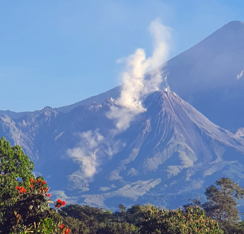 |
Figure 129. Photo of white gas-and-steam emissions rising above the Caliente dome of Santa María at 0845 on 24 November 2021. Courtesy of CONRED (Informative Bulletin No. 532-2021). |
Activity consisting of weak degassing over the Caliente dome rising 150-800 m above the vent and weak to moderate avalanches persisted during December. Some of the avalanches were preceded by explosions; effusive activity continued to build up the W flank and the lava dome. Intermittent ash plumes rose to altitudes of 3-3.4 km and extended generally to the S, SW, and W. On 3 December an ash plume rose to 3 km altitude and drifted NW and W as far as 10 km and, as a result, ashfall was reported in San Marcos Palajunoj and Loma Linda. An explosion on 13 December produced an ash plume that dispersed to the W and SW as far as 15 km and ashfall was reported in the villages of San Marcos and Loma Linda Palajunoj. Ash was also reported in these villages on 17, 18, 28, and 31 December. During the night and early morning of 16-17 December intense incandescence was observed on the W and SW edge of the Caliente dome, accompanied by block avalanches descending the W, SW, and S flanks. On 29 December an explosion expelled an ash plume to 3.2 km altitude that drifted for 10 km to the W and NW, followed by fine ashfall in Loma Linda Palajunoj, San Marcos Palajunoj, and Llanos del Pinal.
White and gray gas-and-steam emissions rose 100-600 m above the crater that generally expanded to the W and SW and weak-to-moderate explosions ejecting ash plumes to 2.8-3.4 km altitude persisted during January 2022. At night and during the early morning, persistent and strong incandescence was observed from the Caliente dome. Frequent moderate-to-strong block avalanches continued descend mostly the W, SW, and S flanks, and weaker ones down the NE, SE, and E flanks, some of which reached the base of the dome. During 2-3, 8, 12-14, 17-18, 22-23 January ash plumes rose to 3.1-3.3 km altitude that drifted W and NW for 10-15 km, causing ashfall in the villages of Loma Linda Palajunoj, San Marcos Palajunoj, and Llanos del Pinal. On 7, 17, 22 January two lava flows were reported on the W and SW flanks with lengths of 500 and 700 m, respectively. In addition, explosions generated an ash plume that rose to 3.2 km altitude and drifted W and NW for 10 km, causing ashfall in the villages of Loma Linda Palajunoj, San Marcos Palajunoj, and Llanos del Pinal. On 29 January moderate to strong ashfall was reported in Loma Linda Palajunoj, San Marcos Palajunoj, El Palmar, and Quetzaltenango. From the early morning on 30 January through 1800 on 31 January, 10 pyroclastic flows were detected by seismic sensors and surveillance cameras. Gas-and-steam emissions persisted over the Caliente dome as high as 600 m.
Intermittent low-level thermal activity was recorded during August through October 2021, as reported by MIROVA (figure 130). Beginning in November, the frequency and power of the anomalies gradually increased through January 2022. According to MODVOLC infrared satellite data from NASA’s MODIS instrument, a total of 21 hotspots were detected over the Caliente vent on 17, 19, 23, 26, and 30 December and 2, 12, 18, 19, 20, 24, and 29 January. On clear weather days, Sentinel-2 infrared satellite imagery showed a small thermal anomaly over the Caliente vent; on 2 January 2022 a linear anomaly was visible on the W flank, which was likely the result of incandescent blocks or a pyroclastic flow (figure 131).
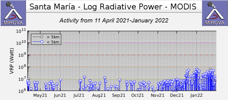 |
Figure 130. Low-level intermittent thermal activity was detected at Santa María during August through October 2021, based on data from MIROVA (Log Radiative Power). Anomalies were followed by an increase in both frequency and power beginning in November and continuing through January 2022. Courtesy of MIROVA. |
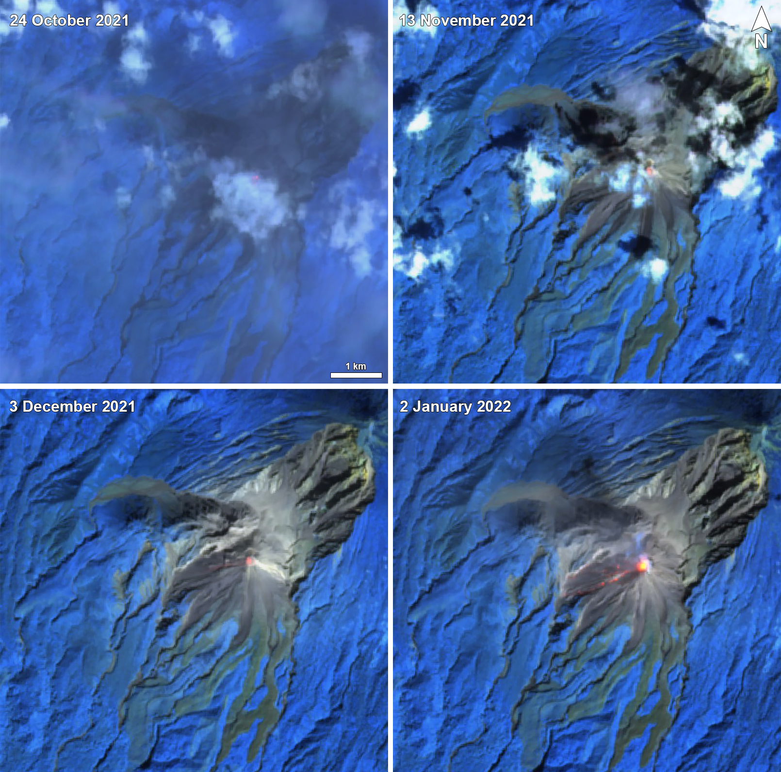 |
Figure 131. Sentinel-2 infrared satellite imagery showed a small thermal anomaly over the Caliente vent of Santa María on 24 October (top left), 13 November (top right), 3 December (bottom left) 2021, and 2 January (bottom right) 2022. A linear thermal anomaly was visible on the W flank originating from the Caliente vent on 2 January, which was likely due to either incandescent blocks or a pyroclastic flow. Images use Atmospheric penetration rendering (bands 12, 11, 8a). Courtesy of Sentinel Hub Playground. |
Information Contacts: Instituto Nacional de Sismologia, Vulcanologia, Meteorologia e Hydrologia (INSIVUMEH), Unit of Volcanology, Geologic Department of Investigation and Services, 7a Av. 14-57, Zona 13, Guatemala City, Guatemala (URL: http://www.insivumeh.gob.gt/); CONRED, Coordinadora Nacional para la reduccion de desastres (URL: https://conred.gob.gt/); MIROVA (Middle InfraRed Observation of Volcanic Activity), a collaborative project between the Universities of Turin and Florence (Italy) supported by the Centre for Volcanic Risk of the Italian Civil Protection Department (URL: http://www.mirovaweb.it/); Hawai'i Institute of Geophysics and Planetology (HIGP) - MODVOLC Thermal Alerts System, School of Ocean and Earth Science and Technology (SOEST), Univ. of Hawai'i, 2525 Correa Road, Honolulu, HI 96822, USA (URL: http://modis.higp.hawaii.edu/); Sentinel Hub Playground (URL: https://www.sentinel-hub.com/explore/sentinel-playground).
Ash plumes, block avalanches, and lava flows persist during February-July 2022
The Santiaguito lava-dome complex of Guatemala's Santa María volcano has been actively erupting since 1922. It formed within a large crater on the SW flank which was created during the 1902 eruption. Ash explosions, pyroclastic flows, and lava flows have emerged from Caliente, the youngest of the four vents in the complex, for more than 40 years. The Caliente vent has an elevation of about 2.5 km, and the summit of Santa Maria is at about 3.7 km elevation. A lava dome that appeared within the summit crater of Caliente in October 2016 has continued to grow, producing frequent block avalanches down the flanks. Recent activity, including frequent explosions, ash plumes, and block avalanches (BGVN 47:04), continued during February through July 2022, described here using information from Guatemala's INSIVUMEH (Instituto Nacional de Sismologia, Vulcanologia, Meterologia e Hidrologia) and satellite data.
Activity during February consisted of white-to-gray gas-and-steam emissions that rose to 200-800 m above the dome and drifted N, W, and SW. Moderate avalanches were reported down the SW, W, S, and NE flanks. Many of these avalanches reached the base of the lava dome and caused ashfall to the W and SW of the volcano, which primarily affected Loma Linda (6 km WSW) and San Marcos Palajunoj (8 km SW). The Caliente lava dome continued to grow and show nighttime and early morning crater incandescence as lava effusions occurred to the WSW. Resulting block-and-ash avalanches occurred frequently throughout the month. On 2 February ashfall was reported in Loma Linda Palajunoj and San Marcos Palajunoj. On 3 February pyroclastic flows were recorded at 0303, 0327, and 0633 that descended the SW and W flanks. As a result, fine ash particles were also generated, moving W and SW, some of which was reported in San Martin Sacatepéquez (11 km NW), Llanos del Pinal (6 km NNE), Xecaracoj (7 km NNE), Loma Linda, and El Palmar (12 km SSW), all in the department of Quetzaltenango. A distinct sulfur smell was detected 7 and 8 km SW of the volcano on 3 and 4 February, respectively. During the night and early morning of 4-5 February weak incandescence was visible from the Caliente dome and lava flows were reported on the W flank. Avalanches remobilized ash to 4 km altitude, which drifted as far as 30 km to the SSW. Two lava flows were reported on the W and SW flanks on 6 February, measuring 500 and 700 m long, respectively. Ashfall was reported in San Marcos Palajunoj, San Luis, and San Sebastián. Crater incandescence at the Caliente dome persisted. A lahar descended the San Isidro River, a SSW-flank tributary of the Tambor River, on 8 February. By 11 February the two lava flows on the W and SW flank reached 600 and 800 m long, respectively, and ash that was generated by frequent avalanches was deposited in Loma Linda Palajunoj and San Marcos Palajunoj. On 26 February incandescence was visible as high as 75 m above the dome.
During March, gas-and-steam emissions that rose 100-1,000 m high over the Caliente dome drifted in different directions. Weak to moderate block avalanches affected the SW, W, and S flanks, causing fine ashfall around the perimeter of the volcano. Nighttime and early morning crater incandescence was consistently visible; lava effusions in the WSW direction persisted in the lava dome. Lava flows remained active on the W and SW flanks. The front of the lava flow in the San Isidro river showed signs of collapse on 24 and 29 March, which generated an ash plume 300 m high.
Similar eruptive activity continued during April, with gas-and-steam emissions rising 50-800 m above the crater and drifted dominantly W and SW. Nighttime crater incandescence in the vicinity of the lava dome persisted, as the lava flows on the W and SW flanks remained active. Fine ash deposits were visible on the SW flank on 1 April. A sulfur odor was intermittently during the month. Avalanches of variable strength were recorded in the front of the lava flows on mainly the W and SW flanks, as well as on the SE, S, and N flanks. The avalanches also generate ash plumes that move W, depositing ashfall on San Marcos Palajunoj and Loma Linda Palajunoj during 2-3 April. Residents also reported the smell of sulfur in Las Marias. Collapses from the lava flow front into the San Isidro river on 4, 10, and 16 April generated ash plumes up to 300 m high. By 14 April the lava flow had reached 2,100 m elevation, with material piling up at the front of the flow as well as around the Caliente dome. Ashfall was reported in San Marcos Palajunoj and Loma Linda Palajunoj that same day.
White-to-gray gas-and-steam emissions continued to rise 400-800 m above the crater and drifted in various directions during May. Nighttime and early morning incandescence was observed from the growing Caliente lava dome and the active lava flows on the W and SW flanks. Weak to moderate avalanches were recorded at the front of the flows on the W and SW flanks, as well as down the S flank. Occasional ashfall deposits and the smell of sulfur were reported in communities around the volcano. During 9-15 May suspended ash was reported in multiple locations. On 14 and 20 May incandescence was visible at night 75 m above the Caliente dome; the lava flow remained active on the W and SW flanks. On 22 May collapses at the front of the lava flow, which measured 3 km long, produced an ash plume 300 m high. Ash deposits were reported during 22-23 May near the summit, including in El Faro, La Florida, and San José. By 24 May the lava flow reached 3.3 km long in the San Isidro river and continued to generate ash plumes to the S and SW from avalanches. On 27 May ashfall was detected in San Marcos Palajunoj and Loma Linda Palajunoj. Cement-like lahars descended the Cabello de Ángel drainage (a tributary of Nimá I on the SE flank) during 27-28 May, carrying tree trunks, branches, and blocks up to 1 m in diameter. On 29 May an ash plume was reported to 3 km altitude and weak-to-moderate avalanches and lava flows continued on the WSW and S flank.
Activity continued during June with constant gas plumes rising 200-700 m above the Caliente dome that drifted as far as 5 km E and 8 km SW. Weak avalanches were constantly observed on the W, SW, and S flanks, as well as in the dome. A lava flow continued to descend the SW and W flanks, which resulted in weak avalanches, incandescence, and some ashfall deposits. On 3 and 9 June the active lava flow in the San Isidro river produced avalanches that caused ash to rise 300 m above the crater. Occasionally a weak sulfur odor was noted around the volcano. Fine ashfall was reported in Santa Mara and Viejo Palmar on 4 June. Ashfall was also visible on 7 June in San Marcos Palajunoj, on 11 and 16 June deposits were reported in the upper part of Finca El Faro and San José Patzulin, and on 12 and 27 June deposits were visible in San Marcos Palajunoj and Loma Linda Palajunoj. Weak to moderate avalanches generated 1-km-high ash plumes that drifted SW as far as 5 km.
Activity persisted during July. White gas-and-steam emissions rose 100-700 m above the crater and drifted SW and W; on 22 and 23 July the emissions drifted as far as 6 km SW and W. Incandescence continued to be visible above the Caliente dome. Block avalanches descended the W, SW, S, and SE flanks, generating ash emissions. The active lava flow measured 3 km long on the SW and W flanks on 1 July, and by 7 July it was 3.5 km long. On 6 July an ash plume rose 1 km above the crater due to the constant avalanches down the W, SW, and S flanks. Ashfall was reported in San Marcos Palajunoj and Loma Linda Palajunoj on 9 July. By 15 July the active lava flows measured 3.8 km long, moving down the San Isidro and Tambor drainages. On 23 and 28 July the avalanches generated ash emissions that rose 800 m above the crater that extended 3 km E. Some lava flow deposits were observed in the Seco river. Ashfall deposits were reported in La Florida and Santa Marta farms on 25 July. INSIVUMEH reported that on 31 July the block avalanches generated moderate pyroclastic flows that burned parts of nearby vegetation.
Persistent thermal activity was recorded during February through July 2022, as reported by MIROVA (figure 132). The rate of the anomalies was higher during January through March, though the levels at which they occurred were relatively consistent. There was a brief gap in activity during late March through late April, where few low- to moderate-power anomalies were detected. During late April the anomalies continued at a slightly higher rate. The MODVOLC thermal algorithm detected a total of 59 hotspots on 3, 5, 9, 12, 14, 15, 16, 18, 20, 21, 23, 26, and 28 February, 2, 4, 6, 7, 13, 14, 15, 16, 19, and 25 March, 2, 17, 19, and 24 April, 3 May, 23 June, and 1, 5, 13, 18, and 25 July. On clear weather days, Sentinel-2 infrared satellite imagery showed a small thermal anomaly over the Caliente vent on 21 February and 7 April 2022 (figure 133).
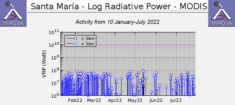 |
Figure 132. Moderate-power thermal anomalies were common at Santa María during 10 January 2022 through July 2022, as seen on this MIROVA graph (Log Radiative Power). Anomalies were more frequent during January through March 2022 and remained at a relatively consistent level. There was a short gap in activity during late March through late April, when fewer anomalies were detected. Then, during late April anomalies continued, though at a lower frequency compared to January-March. Courtesy of MIROVA. |
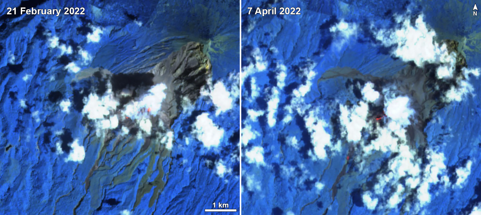 |
Figure 133. Sentinel-2 infrared satellite imagery showed small thermal anomalies over the Caliente vent of Santa María on 21 February and 7 April 2022 (left and right, respectively). Clouds often covered the summit. Images use Atmospheric penetration rendering (bands 12, 11, 8a). Courtesy of Sentinel Hub Playground. |
Information Contacts: Instituto Nacional de Sismologia, Vulcanologia, Meteorologia e Hydrologia (INSIVUMEH), Unit of Volcanology, Geologic Department of Investigation and Services, 7a Av. 14-57, Zona 13, Guatemala City, Guatemala (URL: http://www.insivumeh.gob.gt/); MIROVA (Middle InfraRed Observation of Volcanic Activity), a collaborative project between the Universities of Turin and Florence (Italy) supported by the Centre for Volcanic Risk of the Italian Civil Protection Department (URL: http://www.mirovaweb.it/); Hawai'i Institute of Geophysics and Planetology (HIGP) - MODVOLC Thermal Alerts System, School of Ocean and Earth Science and Technology (SOEST), Univ. of Hawai'i, 2525 Correa Road, Honolulu, HI 96822, USA (URL: http://modis.higp.hawaii.edu/); Sentinel Hub Playground (URL: https://www.sentinel-hub.com/explore/sentinel-playground).
Explosions, avalanches, ash plumes, and ashfall during August-November 2022
The Santiaguito lava-dome complex of Guatemala's Santa María volcano has been actively erupting since 1922. The lava dome-complex formed within a large crater on the SW flank of Santa Maria that formed during the 1902 eruption. Ash explosions, pyroclastic flows, and lava flows have emerged from Caliente, the youngest of the four vents in the complex, for more than 40 years. The Caliente vent has an elevation of about 2.5 km, and the summit of Santa Maria is at about 3.7 km elevation. A lava dome that appeared within the summit crater of Caliente in October 2016 has continued to grow, producing frequent block avalanches down the flanks. Recent activity, including ash plumes, block avalanches, and lava flows (BGVN 47:08) has continued during August through November 2022, using information from Guatemala's INSIVUMEH (Instituto Nacional de Sismologia, Vulcanologia, Meterologia e Hidrologia) and satellite data.
Activity during August consisted of white gas-and-steam emissions that rose 200-800 m above the crater and drifted 3-12 km SW, W, S, SE, and NW. Active flows were detected on the W, SW, SE, WSW, and S flanks throughout the month. Nighttime and early morning incandescence was recorded in the crater of the Caliente dome, and weak-to-moderate block-and-ash avalanches on the W, SW, WSW, S, and SE flanks and at the front and middle of active lava flows; fine ash particles remained suspended in the area due to the avalanches. Ash plumes resulting from the block-and-ash avalanches rose 50 m-1.5 km above the crater and drifted E and W. On 3 August fine ashfall and a faint smell of sulfur was reported 15 km S of the volcano. Collapses were observed in the front of the active lava flow in the San Isidro (SSW) and El Tambor drainages on 4 August. These collapses generated loud sounds resulting from rock falls and raised ash columns up to 1 km high that produced ashfall in the surrounding area on 4-5, 8, 20, and 26 August, including La Florida (6 km S), Monte Claro, San Marcos Palajunoj (8 km SW), and Loma Linda (7 km W). By 6 August the lava flow in the San Isidro drainage measured approximately 3.7 km long. As it continued to move, avalanches with moderate pyroclastic flows were generated, burning some vegetation, and distributing ash plumes to the SW. Fine ash particles and the smell of sulfur were reported in Las Marías on 6 August. INSIVUMEH reported that on 12 August the lava flow on the SW flank of the Caliente dome measured 4 km long. During 17-18 and 25 August strong rainfall generated lahars in the Cabello de Ángel drainage toward the SSE, E, and SW flanks of the volcano. Lahars carried rocks up to 1 m in diameter and tree trunks and branches. Collapses from the middle part of the lava flow in the San Isidro and El Tambor drainages generated ash columns that rose 100-500 m above the surface on 20 August. A faint sulfur smell was also reported up to 10 km S of the volcano. On 24 August ashfall was reported in San Marcos Palajunoj. The active lava flow on the SW flank that moved to the W and SW was 4.2 km long on 30 August 2022.
Similar activity continued during September, with gas-and-steam emissions rising 200-800 m above the Caliente dome and drifting as far as 10 km in different directions. Dome incandescence and block-and-ash avalanches descending the W, SW, and S flanks were reported. Occasional explosions caused incandescent material to descend all sides of the Caliente dome. Some block collapses at the front and middle of the active lava flow in the San Isidro and El Tambor drainages and on the S, SE, WSW, and E flanks generated ash clouds that rose 500-600 m above the surface and drifted up to 7 km W and SW. On 5 September the lava flow from the SW flank remained 4.2 km long. On 8, 9, 13, 19, and 27 September strong rainfall generated lahars in the Cabello de Ángel drainage toward the SSW and SSE, carrying tree trunks, branches, and blocks up to 1 m in diameter. Fine ash was uplifted from avalanches on 15 September and distributed SW, causing ashfall in Monte Claro. Seismic stations recorded some weak explosions that produced gas-and-steam plumes during 27-28 September.
During October, gas-and-steam emissions rose 300-1,000 m above the Caliente dome that drifted as far as 7 km and in different directions. Incandescence was visible in the dome and avalanches descended the W, S, and SW flanks. Block collapses continued at the front of the active lava flow in the San Isidro, El Tambor, and Zanjón Seco drainages and the WSW and S flanks, which generated ash plumes that rose several hundred meters above the surface. Seismic stations recorded weak explosions that produced gas-and-steam emissions on 4, 10, 15, and 27 October. On 7 October the smell of sulfur was reported to the W and SW of the volcano. Weak explosions on 7 October ejected incandescent material that fell on all flanks of the dome. On 12, 13, 21, and 30 October weak avalanches produced fine ash particles that fell around the perimeter of the volcano. On 17 October the lava flow on the SW flank remained 4.2 km long. During 27-29 and 31 October ash was generated from avalanches of material that drifted to the SE and S.
Gas-and-steam emissions during November rose 200-700 m above the crater and drifted as far as 6 km in multiple directions. Constant crater incandescence was observed, and active lava flows traveled WSW, W, SW, and S. Weak-to-moderate avalanches occurred in the front and middle of the lava flow on the W, SW, and S flanks, sometimes causing fine ash particles to fall on the volcanic perimeter. Seismic stations recorded periods of degassing and occasional explosions that generated gas-and-steam plumes on 3 and 8 November; on 23 November a gas-and-steam and ash plume rose 700 m above the crater. Due to heavy rainfall, lahars were reported in the Cabello del Ángel drainage on 3 and 7 November moving to the SSW, carrying tree trunks and branches and blocks up to 1 m in diameter. On 5 November weak-to-moderate explosions generated fine ashfall in Finca San José and La Quina. Block collapses from the lava flow in the San Isidro, El Tambor, and Zanjón Seco drainages produced ash clouds that rose to several hundred meters above the surface on 6, 14, 15, 18, and 29 November. On 6 November the effusion rate and advancement of the lava flow markedly decreased in the El Tambor and San Isidro drainages. INSIVUMEH reported that on 16 November the active lava flow stopped advancing. On 22 November explosions were detected in the summit crater, accompanied by nighttime crater incandescence and constant avalanches on the W and SE flanks. Explosions on 24 November generated a gray ash plume that rose 700 m above the crater and drifted SW.
The MIROVA (Middle InfraRed Observation of Volcanic Activity) graph showed low-to-moderate thermal anomalies during the reporting period (figure 134). There were two short gaps in activity during early September and late September through early October. A total of 13 MODVOLC thermal alerts were issued: four during August, one during September, four during October, and four during November. Due to bad weather, clear views of the summit were obscured in infrared satellite imagery.
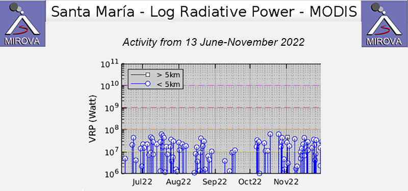 |
Figure 134. Low-to-moderate thermal anomalies were often detected at Santa María during August through November 2022, as shown on this MIROVA graph (Log Radiative Power). Anomalies varied in intensity, and two short gaps in activity were noted during early September and late September through early October. Courtesy of MIROVA. |
Information Contacts: Instituto Nacional de Sismologia, Vulcanologia, Meteorologia e Hydrologia (INSIVUMEH), Unit of Volcanology, Geologic Department of Investigation and Services, 7a Av. 14-57, Zona 13, Guatemala City, Guatemala (URL: http://www.insivumeh.gob.gt/); MIROVA (Middle InfraRed Observation of Volcanic Activity), a collaborative project between the Universities of Turin and Florence (Italy) supported by the Centre for Volcanic Risk of the Italian Civil Protection Department (URL: http://www.mirovaweb.it/); Hawai'i Institute of Geophysics and Planetology (HIGP) - MODVOLC Thermal Alerts System, School of Ocean and Earth Science and Technology (SOEST), Univ. of Hawai'i, 2525 Correa Road, Honolulu, HI 96822, USA (URL: http://modis.higp.hawaii.edu/).
Active lava flows, explosions, ash plumes, and ashfall during December 2022-March 2023
The Santiaguito lava-dome complex of Guatemala's Santa María volcano has been actively erupting since 1922. The lava dome-complex formed within a large crater on the SW flank of Santa Maria that formed during the 1902 eruption. Ash explosions, pyroclastic flows, and lava flows have emerged from Caliente, the youngest of the four vents in the complex, for more than 40 years. The Caliente vent has an elevation of about 2.5 km, and the summit of Santa Maria is at about 3.7 km elevation. A lava dome that appeared within the summit crater of Caliente in October 2016 has continued to grow, producing frequent block avalanches down the flanks. Recent activity has included frequent explosions, ash plumes, and ashfall (BGVN 48:03) has persisted for this reporting period of December 2022 through March 2023, using information from Guatemala's INSIVUMEH (Instituto Nacional de Sismologia, Vulcanologia, Meterologia e Hidrologia) and satellite data.
Activity during December 2022 consisted of weak-to-moderate explosions and white-to-gray and blue gas-and-steam emissions that rose 200-800 m above the crater and drifted up to 15 km SW, NW, S, W, SSW, E, SE, and N. Explosions generated ash plumes that drifted as far as 6 km W and SW. Nighttime crater incandescence was often visible above the Caliente dome, accompanied by active lava flows that mainly traveled down the W, SW, and WSW flanks each day during December, also affecting the San Isidro (W) and El Tambor (SW) drainages. Frequent block-and-ash avalanches were detected on the W, WSW, S, and SE flanks, which sometimes resulted in ash plumes that drifted up to 10 km downwind. Ashfall was reported in Finca la Mosqueta and Santa Marta (5-6 km SW) on 2 December and in Las Marías (10 km S), Viejo Palmar, and the Palajunoj area on 9 December. On 11 December the active lava flow in the San Isidro and El Tambor drainages generated some block collapses, which resulted in ash clouds that rose several hundred meters high and drifted toward the Zanjón Seco drainage (SW flank). On 13, 18, 27, and 31 December block collapses from the lava flow generated ash clouds that rose several hundred meters high and drifted toward the San Isidro drainage. The smell of sulfur was reported on 13 December to the SE of the Caliente dome and on 14 December in the Las Marías area. Ashfall was recorded in Lotación Las Marías, Santa Marta, La Florida (6 km S), and El Faro (7 km S) on 22 December, which was accompanied by the smell of sulfur. Explosions on 27 and 31 December resulted in weak ashfall in El Faro, La Florida, Santa Marta, El Viejo (11 km S), El Palmar (12 km SSW), and Lotación Las Marías.
Daily white-to-gray gas-and-steam emissions continued during January 2023, rising 300-900 m above the crater, and drifting 3.5-8 km SW, W, S, SE, and E. Weak-to-moderate explosions persisted throughout the month, generating ash plumes that rose up to 900 m and drifted E, NE, and SW. Crater incandescence in the Caliente dome, on the S flank, and at the front of the lava flow on the W and SW flanks was visible. Lava flows were often observed on the W, SW, and WSW flanks in the San Isidro and El Tambor drainages; on 19 and 23 January the active lava flow was noted in the Zanjón Seco and San Isidro drainages and the longest part of the lava flow was 4.4 km on 15 January. Weak-to-moderate block collapses and block-and-ash avalanches were recorded at the middle and front of the lava flow on the W, SW, and WSW flanks of the Caliente dome, and on the S and SE flanks, which sometimes caused ash to rise as high as 1 km altitude and disperse 3 km to the W and S (figure 135). On 7 January explosions generated ash plumes that rose to 3 km altitude and drifted SW. On 9 January ashfall was recorded over Las Marías and El Viejo Palmar. The active lava flow in the San Isidro and El Tambor drainages generated some block collapses on 11 January, which produced ash plumes that rose several hundred meters high and caused weak ashfall in El Faro, La Florida, Santa Marta, El Viejo Palmar, and Las Marías. Ashfall was recorded at Monte Carlo on 13 January, weak ashfall was reported in El Faro, La Florida, Santa Marta, El Viejo Palmar, and Las Marías on 19 January, and weak ashfall was again reported on 23 January in Monte Claro, El Faro, La Florida, Santa Marta, and El Viejo Palmar.
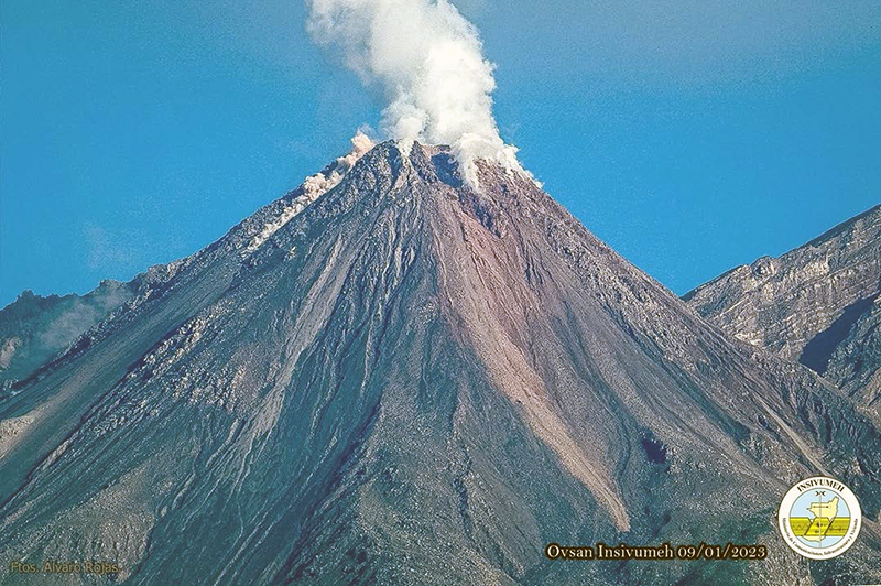 |
Figure 135. Image of gas-and-steam emissions rising above the Caliente dome at Santa María on 13 January 2023, accompanied by block avalanches descending the flanks. Photo has been color corrected. Courtesy of INSIVUMEH (BOLETÍN VULCANOLÓGICO ESPECIAL BESAN #001-2023, Guatemala 15 de enero de 2023, 18:30 horas (Hora Local)). |
Similar activity persisted during February with frequent explosions that produced white gas-and-steam and ash emissions that rose 200-700 m above the crater and drifted SW, W, SE, E, and NW. During the night and early morning, constant crater incandescence at Caliente dome was observed, in addition to incandescence from the active lava flow on the W, SW, and WSW flanks. Weak-and-moderate avalanches were visible on the S, SW, W, SE, WSW, and E flanks and in the middle and front of the lava flow, sometimes generating ash clouds that rose several hundred meters high. Explosions on 3 February expelled gas-and-ash plumes that rose to 3.2 km altitude and drifted W. On 4 February explosions were accompanied by audible rumbles heard in El Palmar; gas-and-ash plumes rose several hundred meters above the lava dome and incandescent avalanches traveled W, S, and SE on the flanks. That same day, the lava flow was reported in the Zanjón Seco and San Isidro drainages; block collapses generated ash clouds that rose several hundred meters high. Weak ashfall was reported in Monte Claro, El Faro, La Florida, Santa Marta, and El Viejo Palmar. Seismic stations registered weak-to-moderate explosions that produced gray plumes that rose to 3.3 km altitude on 8, 11, and 19 February, which generally drifted W and SW. On 9 February ash plumes that rose 800 m above the crater and extended E. Explosions and block collapses on 12 February caused ashfall in Monte Claro, El Faro, La Florida, Santa Marta, and El Viejo Palmar. During the early morning of 15 February, four explosions were detected that generated gray plumes that rose to 2.9 km altitude. Nine explosions were recorded on 16 February, which produced gray plumes and generated weak avalanches on all flanks. On 20 February weak ashfalls from explosions and block collapses were reported in Monte Claro, El Faro, La Florida, Santa Marta, and El Viejo Palmar. Measurements taken on 23 February showed that the length of the lava flow was 4.3 km long.
During March, degassing 400-800 m above the crater dispersed W, SW, S, and SE, and nighttime crater and lava flow incandescence to the WSW continued. Weak-to-moderate avalanches were reported on the S, W, SE, E, and N flanks and from the middle and front of the lava flow. The lava flow remained active on the SW, W, and WSW flanks and in the Zanjón Seco and San Isidro drainages, occasionally accompanied by block collapses that generated ash clouds up to several hundreds of meters high. Weak-to-moderate explosions persisted throughout the month, producing gas-and-ash emissions rising 500-1,000 m above the crater and drifting SW. On 19 March a gas-and-ash plume rose to 3.2 km altitude and drifted S and SE; the lava flow remained at 4.3 km long on the SW flank, according to INSIVUMEH. Additionally, strong rains in the upper part of the volcanic complex caused a lahar to descend the Cabello de Ángel drainage on the SE flank, consisting of a cement-like mixture of volcanic material and transporting tree branches of varying sizes. Small pyroclastic flows were reported during 22-23 March. Explosions on 23 March generated an ash plume that rose to 3.5 km altitude and drifted W and on 24 March ash plumes rose to 4.3 km altitude and drifted W. On 31 March explosions produced ash plumes that rose to 3.5 km altitude and drifted W, accompanied by constant avalanches on the S, SW, E, and N flanks of the Caliente dome and small pyroclastic flows.
The MIROVA (Middle InfraRed Observation of Volcanic Activity) graph showed moderate-power thermal anomalies during the reporting period; the intensity gradually increased over January through March, and the frequency remained relatively high (figure 136). A total of 75 MODVOLC thermal alerts were issued on 40 days during December-March. Incandescent avalanches and active lava flows were also occasionally visible over the Caliente dome in Sentinel-2 infrared satellite imagery on clear weather days (figure 137).
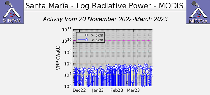 |
Figure 136. Moderate-power thermal anomalies were frequently detected at Santa María during 20 November 2022 through March 2023, as shown on this MIROVA graph (Log Radiative Power). Anomalies gradually increased in intensity beginning in January through March. Courtesy of MIROVA. |
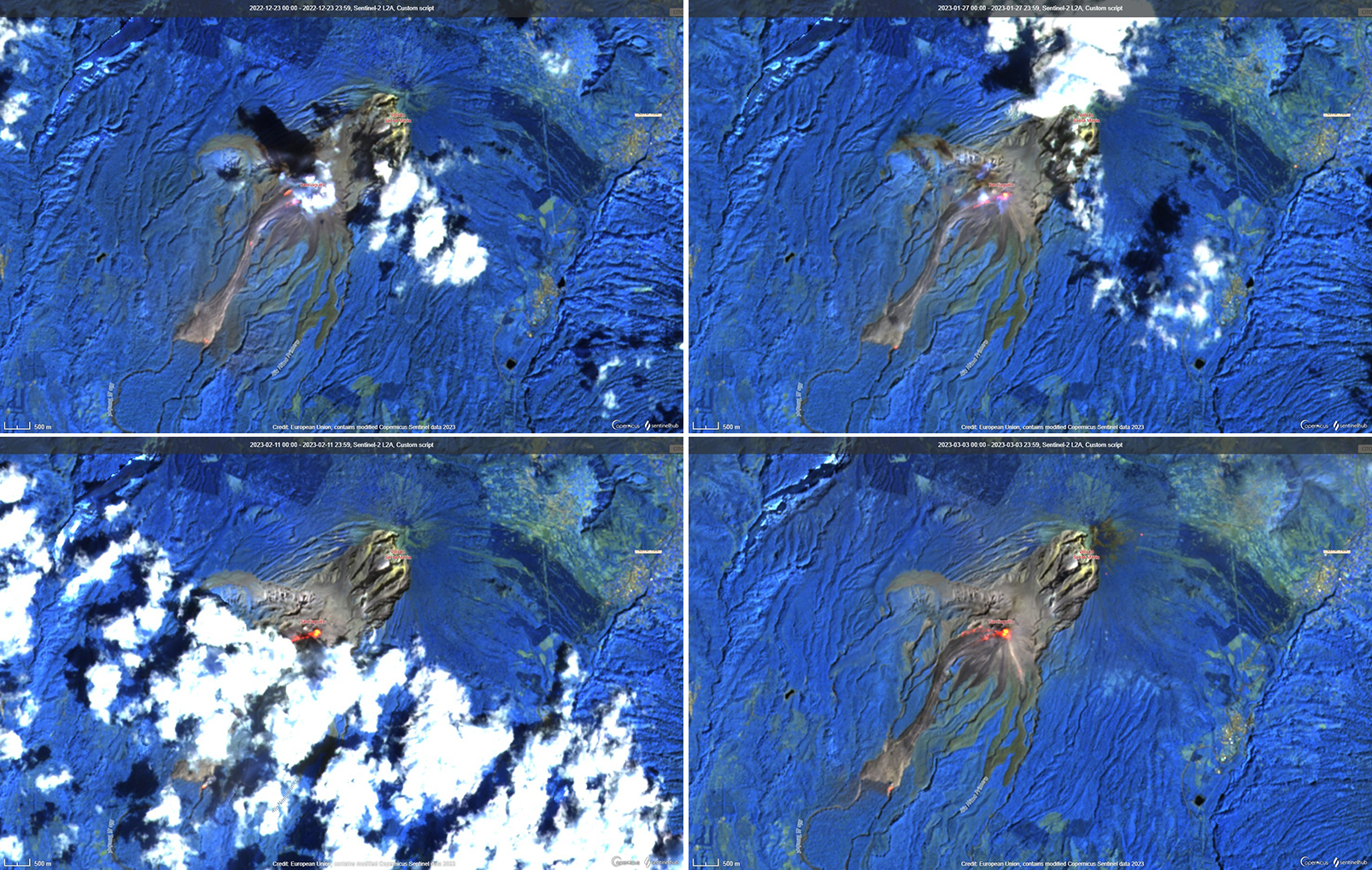 |
Figure 137. Sentinel-2 infrared satellite imagery showing strong thermal activity at the Caliente dome of Santa María and incandescent avalanches and lava flows primarily on the SW and W flanks on 23 December 2022 (top left), 27 January 2023 (top right), 11 February 2023 (bottom left), and 3 March 2023 (bottom right). Clouds often covered the summit. Images rendered using bands 12, 11, 8a. Courtesy of Copernicus Browser. |
Information Contacts: Instituto Nacional de Sismologia, Vulcanologia, Meteorologia e Hydrologia (INSIVUMEH), Unit of Volcanology, Geologic Department of Investigation and Services, 7a Av. 14-57, Zona 13, Guatemala City, Guatemala (URL: http://www.insivumeh.gob.gt/); MIROVA (Middle InfraRed Observation of Volcanic Activity), a collaborative project between the Universities of Turin and Florence (Italy) supported by the Centre for Volcanic Risk of the Italian Civil Protection Department (URL: http://www.mirovaweb.it/); Hawai'i Institute of Geophysics and Planetology (HIGP) - MODVOLC Thermal Alerts System, School of Ocean and Earth Science and Technology (SOEST), Univ. of Hawai'i, 2525 Correa Road, Honolulu, HI 96822, USA (URL: http://modis.higp.hawaii.edu/); Copernicus Browser, Copernicus Data Space Ecosystem, European Space Agency (URL: https://dataspace.copernicus.eu/browser/).
Frequent explosions, lava flows, ash plumes, and pyroclastic flows during April-July 2023
The Santiaguito lava-dome complex of Guatemala's Santa María volcano has been actively erupting since 1922. The lava dome-complex lies within a large crater on the SW flank of Santa Maria formed during the 1902 eruption. Ash explosions, pyroclastic flows, and lava flows have emerged from Caliente, the youngest of the four vents in the complex, for more than 40 years. A lava dome that appeared within the summit crater of Caliente in October 2016 has continued to grow, producing frequent block avalanches down the flanks. Recent activity has included active lava flows, explosions, ash plumes, and ashfall (BGVN 48:04). This report covers activity during April through July 2023, based on information from Guatemala's INSIVUMEH (Instituto Nacional de Sismologia, Vulcanologia, Meterologia e Hidrologia) and satellite data.
Activity during April consisted of daily gas-and-steam emissions, nighttime crater incandescence, weak-to-moderate explosions that produced gas-and-ash emissions, and incandescent avalanches of material that descended the W, S, SE, SW, E, WSW, and N flanks of the Caliente dome. Gas-and-ash emissions rose 500-3,500 m above the crater and drifted W, SW, S, and E. An active lava flow continued mainly in the Zanjón Seco (SW) and San Isidro (W), accompanied by block collapses that raised ash clouds to several hundred meters high. By 4 April it was 4.3 km long on the SW flank of Caliente and continued to generate weak-to-moderate avalanches at the front and margins of the flows; pyroclastic flows also accompanied this activity during 3-4, 7-8, 11-12, 15-16, and 23-24 April. During 9-10 April an ash plume rose 700 m above the crater and drifted 8 km SW. During 15-16 April ashfall was reported in San Marcos Palajunoj (8 km SW), Las Marías (10 km S), Belén (10 km S), and Calaguache (9 km S). During 18-19 April ashfall was recorded in Finca El Faro (7 km S). On 28 April a lahar descended the Cabello de Angel River, a tributary of the Nimá I and Samalá rivers on the E flank and was registered by the nearby seismic stations. On 30 April at 0920 a moderate explosion generated a pyroclastic flow that traveled 5 km SW and produced an ash plume that rose 100 m along the flow. Seismic data confirmed that the event lasted 40 minutes.
Daily gas-and-steam emissions, explosions, and nighttime crater incandescence continued during May. Gas-and-steam emissions rose 200-800 m above the crater and drifted S, SW, W, and SE. Ash plumes rose 500-3,500 m above the crater and drifted SW, SE, S, and W. Block-and-ash avalanches continued around the crater, on the S, SE, SW, W, E, and N flanks, and at the middle and front of the W lava flow. The lava flow remained active on the SW, W, and WSW flanks, generating avalanches along its path. It was 4.3 km in length and accompanied by occasional pyroclastic flows, such as during 5-6, 25-26, and 29-30 May. During 5-6, 9-10, 13-14, 21-22, 25-26, and 29-30 May about 40 explosions were recorded each day, which generated ash plumes that rose 1-3.5 km above the crater and drifted SW, S, SW, and SE. Ashfall was reported in San Marcos Palajunoj and Loma Linda (7 km W) during 5-6 May and in Finca El Faro, Finca El Patrocinio, and Las Marías during 9-10 May. During 26-27 and 30-31 May ashfall was reported in El Faro, La Florida (6 km S), and Patzulin (SW flank).
During June, daily gas-and-steam emissions, explosions, and nighttime crater incandescence persisted. Gas-and-steam emissions rose 200-3,000 m above the crater and drifted SE, W, S, and SW. Avalanches of material were recorded on all flanks of the volcano, as well as from the lava flow; short pyroclastic flows were reported during 2-3, 6-7, 10-11, 18-19, 22-23, 26-27, and 28-29 June affecting the San Isidro drainage. Gas-and-ash plumes rose 500-1,000 m above the crater and drifted W and SW. The active lava flow continued on the WSW, SW, W, and SE flanks. During 2-3, 6-7, 10-11, 18-19, 26-27, and 28-29 June there were an average of 40 explosions each day that produced ash plumes 3.5 km above the crater and drifted S, SE, W, SW, and NW. During 4-5 June ashfall was observed in El Faro, La Florida, and Patzulin. During 8-9 June ashfall was reported in San José and La Quina. During 23-26 June dome incandescence reflected on the eruption plumes was visible up to 500 m above the crater. On 23 June a lahar descended the Río Cabello de Ángel on the E flank. The lahar carried fine volcanic material, volcanic blocks up to 1 m in diameter, and tree trunks and branches.
Similar activity continued with explosions, crater incandescence, and an active lava flow during July. Gas-and-steam emissions rose 300-1,000 m above the crater and drifted W, SW, and NW. Gas-and-ash plumes rose 500-1,000 m above the crater and drifted W, SW, and NW. The continuously active lava flow on the WSW, SW, W, and S flanks caused frequent avalanches of material down the W, SW, S, E, N, and SE flanks, occasionally generating pyroclastic flows in the San Isidro drainage.
The MIROVA (Middle InfraRed Observation of Volcanic Activity) graph showed frequent moderate-power thermal anomalies during the reporting period (figure 138). A total of 49 MODVOLC thermal alerts were issued on 1, 2, 3, 5, 9, 12, 16, 17, 18, 21, 22, 25, and 27 April, 5, 7, 9, 12, 19, 21, and 24 May, 9, 18, and 24 June, and 15, 21, 22, and 26 July. Incandescent avalanches of material and active lava flows were occasionally visible over the Caliente dome and on the S and W flanks in infrared satellite imagery (figure 139).
 |
Figure 138. Moderate-power thermal anomalies were frequently detected at Santa María during 20 November 2022 through July 2023, as shown on this MIROVA graph (Log Radiative Power). Courtesy of MIROVA. |
 |
Figure 139. Infrared (bands B12, B11, B4) satellite images showing crater incandescence over Santa María’s Caliente dome on 22 April 2023 (top left), 7 May 2023 (top right), 16 July 2023 (bottom left), and 26 July 2023 (bottom right). Incandescence was also visible on the S and W flanks. Courtesy of Copernicus Browser. |
Information Contacts: Instituto Nacional de Sismologia, Vulcanologia, Meteorologia e Hydrologia (INSIVUMEH), Unit of Volcanology, Geologic Department of Investigation and Services, 7a Av. 14-57, Zona 13, Guatemala City, Guatemala (URL: http://www.insivumeh.gob.gt/); MIROVA (Middle InfraRed Observation of Volcanic Activity), a collaborative project between the Universities of Turin and Florence (Italy) supported by the Centre for Volcanic Risk of the Italian Civil Protection Department (URL: http://www.mirovaweb.it/); Hawai'i Institute of Geophysics and Planetology (HIGP) - MODVOLC Thermal Alerts System, School of Ocean and Earth Science and Technology (SOEST), Univ. of Hawai'i, 2525 Correa Road, Honolulu, HI 96822, USA (URL: http://modis.higp.hawaii.edu/); Copernicus Browser, Copernicus Data Space Ecosystem, European Space Agency (URL: https://dataspace.copernicus.eu/browser/).
Continuing lava effusion, explosions, ash plumes, and pyroclastic flows during August-November 2023
The Santiaguito lava dome complex of Guatemala’s Santa María volcano has been actively erupting since 1922. The lava dome complex lies within a large crater on the SW flank of Santa María that was formed during the 1902 eruption. Ash explosions, pyroclastic flows, and lava flows have emerged from Caliente, the youngest of the four vents in the complex for more than 40 years. A lava dome that appeared within Caliente’s summit crater in October 2016 has continued to grow, producing frequent block avalanches down the flanks. More recently, activity has been characterized by frequent explosions, lava flows, ash plumes, and pyroclastic flows (BGVN 48:09). This report covers activity during August through November 2023 based on information from Guatemala's INSIVUMEH (Instituto Nacional de Sismologia, Vulcanologia, Meterologia e Hidrologia) and various satellite data.
Activity during August consisted of weak-to-moderate explosions, avalanches of material, gas-and-ash plumes, and incandescence observed at night and in the early morning. Weak degassing plumes rose 300-600 m above the crater. Frequent explosions were detected at a rate of 1-2 per hour, which produced gas-and-ash plumes that rose 200-1,000 m above the crater and drifted W, NW, SW, S, E, and NE. Two active lava flows continued mainly in the Zanjón Seco (SW) and San Isidro (W) drainages. Incandescent block avalanches and occasional block-and-ash flows were reported on the W, S, E, SE, and SW flanks, as well as on the lava flows. On 26 and 29 August, fine ash plumes rose to 3.5 km altitude and drifted E and NE, causing ashfall in Belén (10 km S) and Calaguache (9 km S), as well as Santa María de Jesús (5 km SE) on 29 August.
Daily degassing, weak-to-moderate explosions, gas-and-ash plumes, and nighttime and early morning incandescence in the upper part of the dome continued during September. Explosions occurred at a rate of 1-2 per hour. Gas-and-ash plumes rose 200-1,000 m above the crater and drifted SW, W, SE, and NW. Block avalanches descended the SW, S, SE, and E flanks, often reaching the base of the Caliente dome. These avalanches were sometimes accompanied by short pyroclastic flows, resulting in fires in some vegetated areas. Block-and-ash flows descended all flanks of the Caliente dome on 16 and 24 September following the eruption of gas-and-ash plumes that rose 700-1,000 m above the crater. Gray ash was primarily deposited in the drainages.
Continuous gas-and-steam emissions occurred in October, along with weak-to-moderate explosions, block avalanches, crater incandescence, and an active lava flow on the WSW flank. Explosions occurred at a rate of 1-4 per hour, that generated gas-and-ash plumes rose 200-1,000 m above the crater and drifted in different directions. Block avalanches traveled down the SW, S, SE, and E flanks, sometimes accompanied by small pyroclastic flows. On 21 and 25 October as many as 50 explosions occurred over the course of 24 hours.
Similar activity persisted during November, with frequent explosions, crater incandescence, and block avalanches. The active lava flow persisted on the WSW flank. Weak-to-moderate explosions occurred at a rate of 1-4 per hour. Incandescence was observed at night and in the early morning. Gas-and-ash emissions rose 700-900 m above the crater and drifted W, SW, S, and NW. Block avalanches were reported on the SW, W, S, SE, and E flanks, which deposited gray ash material in the drainages, sometimes reaching the base of the Caliente dome. Those avalanches were sometimes accompanied by small pyroclastic flows that reached the base of the dome on the W, SW, and S flanks. Ashfall was reported in Las Marías (10 km S), El Viejo Palmar (12 km SSW), El Patrocinio, and San Marcos (8 km SW) on 18 and 22 November. On 26 and 30 November ashfall was reported in San Marcos and Loma Linda Palajunoj (7 km SW).
The MIROVA (Middle InfraRed Observation of Volcanic Activity) graph showed frequent moderate-power thermal anomalies during the reporting period (figure 140). A total of 26 MODVOLC thermal alerts were issued on 6, 7, 7, 15, 16, and 21 August, 15 and 23 September, 19, 26, 27, and 29 October, and 2, 7, 11, 27, 28, and 29 November. Clouds covered the summit of the volcano on most days, so thermal anomalies could not be identified in most Sentinel infrared satellite images.
|
Figure 140. Moderate-power thermal anomalies were frequently detected at Santa María during August through November 2023, as shown on this MIROVA graph (Log Radiative Power). Courtesy of MIROVA. |
Information Contacts: Instituto Nacional de Sismologia, Vulcanologia, Meteorologia e Hydrologia (INSIVUMEH), Unit of Volcanology, Geologic Department of Investigation and Services, 7a Av. 14-57, Zona 13, Guatemala City, Guatemala (URL: http://www.insivumeh.gob.gt/); MIROVA (Middle InfraRed Observation of Volcanic Activity), a collaborative project between the Universities of Turin and Florence (Italy) supported by the Centre for Volcanic Risk of the Italian Civil Protection Department (URL: http://www.mirovaweb.it/); Hawai'i Institute of Geophysics and Planetology (HIGP) - MODVOLC Thermal Alerts System, School of Ocean and Earth Science and Technology (SOEST), Univ. of Hawai'i, 2525 Correa Road, Honolulu, HI 96822, USA (URL: http://modis.higp.hawaii.edu/); Copernicus Browser, Copernicus Data Space Ecosystem, European Space Agency (URL: https://dataspace.copernicus.eu/browser/).
|
|
||||||||||||||||||||||||||||
There is data available for 3 confirmed eruptive periods.
1922 Jun 22 - 2025 Sep 19 (continuing) Confirmed Eruption (Explosive / Effusive) VEI: 3
| Episode 1 | Eruption (Explosive / Effusive) | SW flank (Santiaguito) | |||||||||||||||||||||||||||||||||||||||||||||||||||||||||||||||||||||||||||||||||||||||||||||||||||||||||||||||||||||||||||||||||||||||||||||||
|---|---|---|---|---|---|---|---|---|---|---|---|---|---|---|---|---|---|---|---|---|---|---|---|---|---|---|---|---|---|---|---|---|---|---|---|---|---|---|---|---|---|---|---|---|---|---|---|---|---|---|---|---|---|---|---|---|---|---|---|---|---|---|---|---|---|---|---|---|---|---|---|---|---|---|---|---|---|---|---|---|---|---|---|---|---|---|---|---|---|---|---|---|---|---|---|---|---|---|---|---|---|---|---|---|---|---|---|---|---|---|---|---|---|---|---|---|---|---|---|---|---|---|---|---|---|---|---|---|---|---|---|---|---|---|---|---|---|---|---|---|---|---|---|---|
| 1922 Jun 22 - 2025 Sep 19 (continuing) | Evidence from Observations: Reported | |||||||||||||||||||||||||||||||||||||||||||||||||||||||||||||||||||||||||||||||||||||||||||||||||||||||||||||||||||||||||||||||||||||||||||||||
|
List of 27 Events for Episode 1 at SW flank (Santiaguito)
|
||||||||||||||||||||||||||||||||||||||||||||||||||||||||||||||||||||||||||||||||||||||||||||||||||||||||||||||||||||||||||||||||||||||||||||||||
1903 - 1913 Confirmed Eruption (Explosive / Effusive) VEI: 2
| Episode 1 | Eruption (Explosive / Effusive) | SW flank (east end of 1902 crater) | ||||||||||||||||||||||||||||
|---|---|---|---|---|---|---|---|---|---|---|---|---|---|---|---|---|---|---|---|---|---|---|---|---|---|---|---|---|---|
| 1903 - 1913 | Evidence from Observations: Reported | ||||||||||||||||||||||||||||
|
List of 4 Events for Episode 1 at SW flank (east end of 1902 crater)
|
|||||||||||||||||||||||||||||
1902 Oct 24 - 1902 Nov 12 Confirmed Eruption (Explosive / Effusive) VEI: 6 (?)
| Episode 1 | Eruption (Explosive / Effusive) | SW flank | ||||||||||||||||||||||||||||||||||||||||||||||||||||||||||||||||||||||||||||||||||||||||
|---|---|---|---|---|---|---|---|---|---|---|---|---|---|---|---|---|---|---|---|---|---|---|---|---|---|---|---|---|---|---|---|---|---|---|---|---|---|---|---|---|---|---|---|---|---|---|---|---|---|---|---|---|---|---|---|---|---|---|---|---|---|---|---|---|---|---|---|---|---|---|---|---|---|---|---|---|---|---|---|---|---|---|---|---|---|---|---|---|---|
| 1902 Oct 24 - 1902 Nov 12 | Evidence from Observations: Reported | ||||||||||||||||||||||||||||||||||||||||||||||||||||||||||||||||||||||||||||||||||||||||
|
List of 16 Events for Episode 1 at SW flank
|
|||||||||||||||||||||||||||||||||||||||||||||||||||||||||||||||||||||||||||||||||||||||||
This compilation of synonyms and subsidiary features may not be comprehensive. Features are organized into four major categories: Cones, Craters, Domes, and Thermal Features. Synonyms of features appear indented below the primary name. In some cases additional feature type, elevation, or location details are provided.
Synonyms |
||||
| Gagxanul | ||||
Cones |
||||
| Feature Name | Feature Type | Elevation | Latitude | Longitude |
| Brujo, El | Vent | 2273 m | 14° 44' 35.00" N | 91° 34' 59.00" W |
| Caliente | Vent | 2517 m | 14° 44' 22.00" N | 91° 34' 6.00" W |
| Majadas, Las
Galápago, Cerro |
Stratovolcano | 2572 m | 14° 46' 0.00" N | 91° 31' 0.00" W |
| Mitad, La | Vent | 2501 m | 14° 44' 37.00" N | 91° 34' 11.00" W |
| Monje, El | Vent | 2362 m | 14° 44' 34.00" N | 91° 34' 34.00" W |
| Valle, Volcán del | Pyroclastic cone | 3080 m | 14° 46' 8.00" N | 91° 32' 31.00" W |
Domes |
||||
| Feature Name | Feature Type | Elevation | Latitude | Longitude |
| Santiaguito
Santiago Hijo del Volcán Niño de Jesus |
Dome | 2517 m | 14° 44' 30.00" N | 91° 34' 24.00" W |
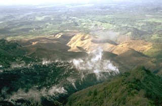 A lava flow from El Brujo, the westernmost of the Santiaguito vents, advances down a SW-flank valley in November 1973. An eruption phase in 1972-75 produced six lava flow units and a small lava dome. It was unusual in that extrusion took place simultaneously from two vents at the western and eastern ends of Santiaguito.
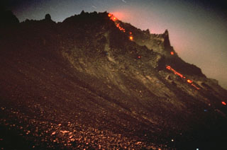 Incandescence is visible at the top of the growing Santiaguito lava dome in Guatemala. Rockfalls of hot material produce a visible trail down its northern flank. The dome began growing in 1922 in a large crater formed on the SW flank of Santa María volcano during a powerful explosive eruption in 1902. Dome growth has been continuous since 1922 and has produced a composite dome over 3 km long. This photo of El Brujo, the westernmost vent, was taken on 12 November 1967.
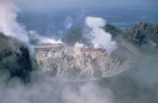 A lava dome fills Caliente crater at the eastern end of the Santiaguito dome complex in June 1968. Gases rise from fumaroles along the margins of the roughly 100-m-wide crater in this view from the north. Periodic ash eruptions accompanied growth of the dome. The Caliente vent is in the oldest part of the Santiaguito dome complex, which began erupting in 1922. It was the source of a major explosive eruption in 1929 that produced large pyroclastic flows.
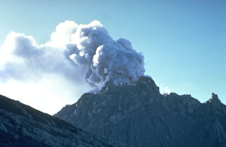 An ash plume rises above the Caliente vent in February 1968. Lava spines protrude from the easternmost vent of the Santiaguito lava dome. The flank of the Santa María edifice appears to the left in this view from the north.
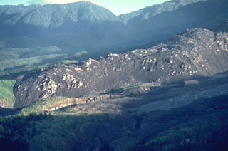 A dacitic lava flow that traveled to the SW from El Brujo vent of Santiaguito is seen in April 1963, a month after it ceased flowing. The slow-moving lava flow is approximately 50 m thick and extended about 1.5 km from the vent. El Brujo, near the western end of the Santiaguito dome complex of Guatemala's Santa María volcano, is the youngest at Santiaguito and was the focus of increased effusive activity from 1959 to 1963.
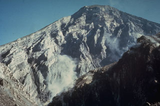 The interior of a stratovolcano is dramatically revealed in a 1-km-wide crater created on the SW flank of Guatemala's Santa María volcano during an eruption in 1902. The 1,200-m-high scarp exposes thin, light-colored lava flows that are interbedded with deposits of fragmented rock produced during growth of the volcano. The 1902 eruption was one of the world's largest during the 20th century.
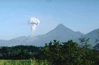 An ash plume rises above the Santiaguito lava dome in March 1988. Explosive eruptions such as these are typical of the growing lava dome since activity began in 1922. The dome was constructed at the base of a large crater, seen here in profile from the Pacific coastal plain to the SE. The crater formed low on the SW flank and extended almost to the summit.
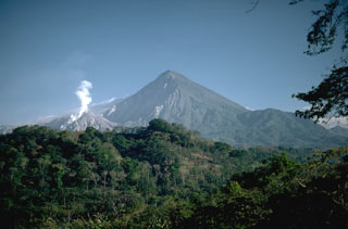 Three distinct stages marked the growth of Santa María. The large edifice formed over a basement of older volcanic and plutonic rocks beginning about 30,000 years ago and ending about 500 to several thousand years ago. A massive eruption in 1902 then created the large crater on the SW flank seen in the shadow left of the summit. The third stage is marked by continued growth of the Santiaguito lava dome complex (left) in the new crater since 1922.
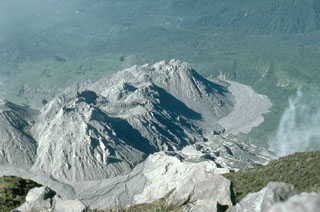 The Santiaguito lava dome has been continually growing since 1922, seen here in December 1993 from the summit of Santa María. Episodic periods of increased growth have occurred from different vents on the dome complex. The Caliente vent is partially seen at the far left, with La Mitad, El Monje, and El Brujo vents located farther west along the 3-km-long crest of Santiaguito.
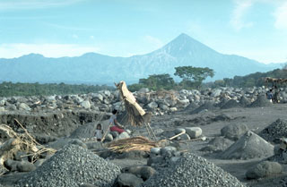 The debris from the Santiaguito lava dome (visible below and to the left of the summit of Santa María) severely impacts downslope river drainages. Frequent rainy season lahars descend the Río Samalá, seen here just south of the Pacific coastal highway. Major lahars on 28 August 1993 (three months prior to this photo) covered 200 m of the highway and filled the river channel to within 50 cm of the highway bridge. A small-scale construction aggregate operation can be seen in the foreground.
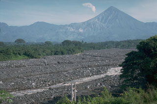 Lahar deposits produced by the remobilization of Santiaguito lava dome collapse deposits. The dome is visible below the steam plume to the left of Guatemala's Santa María volcano. Lahars have dramatic effects on downstream drainages, as seen in this December 1988 photo that shows the Río Tambor to the SW, filled bank-to-bank with debris. Bridges such as the one in the foreground have frequently been destroyed during rainy-season lahars, which have traveled 35 km or more from the volcano.
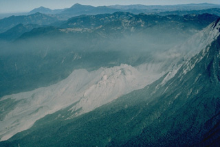 The Santiaguito lava-dome complex (center) has been in continual activity since 1922. It is seen here in March 1983 from the SE, with Siete Orejas volcano forming the broad forested ridge above it and Tacaná (left) and Tajumulco (right) volcanoes appearing on the left skyline. Santiaguito was constructed within the large 1902 explosion crater, which cuts the SW flank of Santa María volcano at the right.
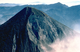 The SW flank of 3772-m-high Santa María volcano, seen here from the west in March 1983, is cut on the right by a large crater produced during an eruption in 1902. The upper rim of the 1-km-wide crater extends to just below the summit. The diffuse smoke plume at the lower right is the remnant of an explosive plume from Santiaguito lava dome, which has been growing since 1922 at the base of the 1902 crater.
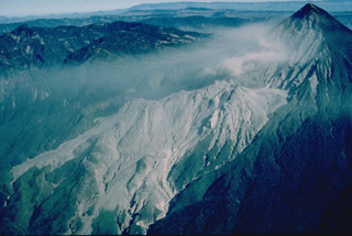 Two decades after a powerful explosive eruption in 1902 blasted a 1-km-wide crater through the SW flank of Santa María volcano, a lava dome began growing at the base of the crater. Santiaguito lava dome, forming the elongated unvegetated ridge at the center of the photo, has been continually active since 1922. Frequent explosive eruptions accompany episodic periods of more rapid lava dome growth and effusion of lava flows down the flanks of the dome. The summit of Santiaguito is about 1300 m below that of Santa María at the upper right.
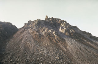 El Brujo vent at the western end of the Santiaguito lava dome complex was the youngest vent when this 10 August 1967 photo was taken from the north. The dome was not yet present in February 1954 aerial photographs, and may have begun growing following a strong explosive eruption on 14 April 1956. A large lava flow was extruded during 1959-63.
 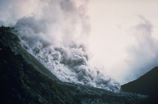 A pyroclastic flow produced by collapse of a growing lava dome descends the northern flank of the Santiaguito lava dome in November 1967. Periodic larger collapses of Santiaguito have sent pyroclastic flows down the populated southern flanks. The most catastrophic of these traveled 10 km in 1929, when hundreds to thousands of people were killed.
 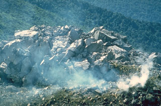 A small blocky lava dome within the Caliente vent on the Santiaguito lava dome of Guatemala's Santa María volcano on 18 July 1969. This was near the beginning of a period of renewed activity at this vent. Growth of the composite Santiaguito lava dome has been ongoing since 1922.
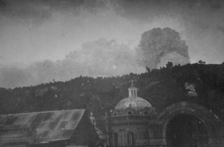 One of the largest eruptions of the 20th century took place 24-25 October 1902 from Santa María. During the Plinian phase explosions were heard in Costa Rica and ash plume heights of 27-29 km were recorded. Ashfall was primarily dispersed NW and eventually reached Mexico City; during the day on 25 October much of the Pacific coastal plain was in darkness. This photo shows an eruption plume on an unknown date from the city of Quetzaltenango, 10 km north of the volcano.
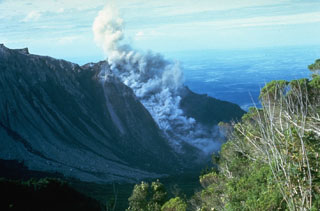 A small block-and-ash flow produced by a small collapse of the growing lava dome descends about 750 m down the north flank of El Brujo dome on 7 July 1967. The Pacific coastal plain is visible in the distance. El Brujo was the westernmost dome of the compound Santiaguito lava dome, which extends about 3 km in a roughly E-W direction.
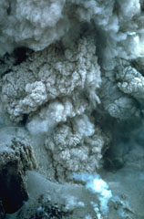 This closeup view of an ash plume rising from the El Brujo lava dome was taken on 13 November 1967. Explosions such as these are common at the growing lava dome, sometimes occurring within minutes of each other. The crater wall is visible at the lower left.
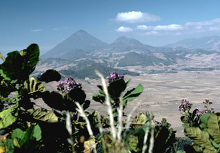 The rounded hills in the middle of the photo are part of a chain of lava domes of the Almolonga volcanic field. Partial flank collapse of an edifice sometime prior to 84,000 years ago formed a 3.3-km-wide collapse scarp that is surrounded by a ring-dike configuration of dacite and rhyolite lava domes, seen here from the east. Cerro Quemado is a young dome near the center of the horizon, right of the larger Santa María, that produced a 2.5-km-long lava flow on its eastern flank in 1818.
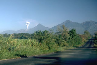 A plume rises from a Santiaguito lava dome on the flank of Santa María. Volcán Santo Tomás is the peak further to the right. A winding ridge connects Santo Tomás to Volcán de Zunil, 4.5 km to the NE, the peak at the far right.
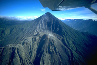 Santa María volcano is seen here in November 1994. The upper SW flank has a 1-km-wide crater formed during a catastrophic eruption in 1902. Two decades later the Santiaguito lava dome began growing at the base of the crater, forming the elongate ridge below the summit and to the left. Since 1922 the Santiaguito dome complex has exhibited frequent explosive activity accompanying episodic periods of dome growth and lava extrusion.
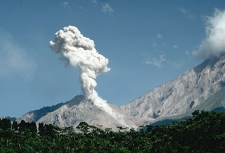 An ash plume rises above Caliente in the Santiaguito lava dome complex in November 1993 as a small pyroclastic flow descends its eastern flank. The headwall of the 1902 crater on the Santa María SW flank is to the right. The lava dome complex began growing in 1922 from the Caliente vent at the base of the 1902 explosion crater. Caliente has been frequently active since the early 1970s.
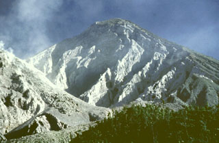 The eroded headwall of the 1.5-km-wide 1902 crater extends from just below the summit down to 2.2 km elevation, where a volume of 0.5 km3 was removed during the eruption. The Santiaguito lava dome complex (left) began growing in the new crater in 1922. This 1991 view shows a lava flow descending the right flank of the dome.
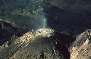 A lava dome fills the crater of the Caliente vent of a Santiaguito lava dome in 1988, as seen from the summit of Santa María. Slow dome growth was accompanied by periodic explosions that ejected ash plumes to about 1.5 km above the vent.
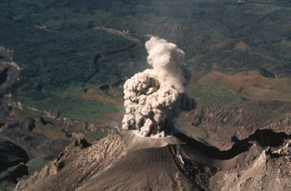 An ash plume rises above Caliente vent at Santiaguito in February 1988. Eruptions at this time took place at intervals of 1 or 2 per hour and consisted of brief 1-2 minute ash emissions that reached altitudes of about 4 km (slightly above the elevation of the summit of Santa María, from where the photo was taken). Light ashfall from these small explosions affected areas to about 6 km from the vent.
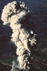 The summit of Santa María provides this vantage point for viewing eruptions of the Santiaguito lava dome. This February 1988 ash plume rose from the vent to a height slightly above the summit. The brief 1-2 minute explosions produced light ashfall to within about 6 km of the vent.
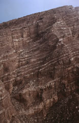 The steep walls of the 1902 explosion crater at Santa María expose a sequence of alternating thin (1-10 m) light-colored lava flows and brownish-colored block-and-ash flow deposits. Growth of the cone involved the extrusion of lava flows, mostly from the summit vent.
 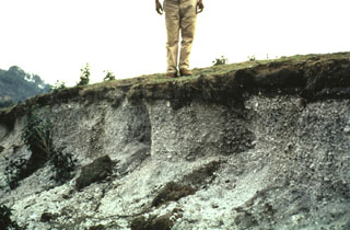 Deposits of the 1902 Plinian eruption are exposed in a 1-m-thick outcrop 3.2 km S of Llano del Pinal, the saddle between Santa María and Siete Orejas volcanoes. The pumice is overlain by about 15 cm of finer-grained darker-colored ash. Most of the outcrop consists of light-colored dacite pumice fragments. Pumice fall was reported in Tapachula across the Mexican border, and ashfall was reported in Mexico City.
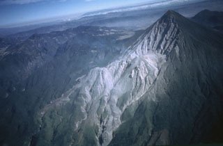 An aerial view from the SE shows the Santiaguito lava dome complex at the base of the 1.5-km-wide 1902 crater on the SW flank of Santa María. Lava flows from the Caliente dome at the eastern side of Santiaguito descend to the bottom center of the photo; lava flows from the western El Brujo vent are visible at the lower left. The broad volcano to the upper left is Siete Orejas.
  Santa María is one of the most active volcanoes in Guatemala. Its morphology changed drastically in 1902 when a catastrophic eruption formed a 1-km-wide crater. The large Santiaguito lava-dome complex (center) has been growing at the base of the 1902 crater since 1922. Lava flows can be seen down the flank. Dome growth is accompanied by frequent minor explosions, along with periodic lava extrusion, larger explosions, pyroclastic flows, and lahars.
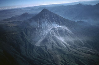 Santa María is one of Guatemala's most active volcanoes. Growth of the degassing Santiaguito lava dome complex began in 1922 at the base of the large crater formed in the Santa María SW flank during a major explosive eruption in 1902. Light-colored volcanic deposits fill the moat to the left of the dome. Lava flows accompanying dome growth descend towards the lower right. The lower peak behind and to the left of Santa María is Cerro Quemado, a lava dome complex within the Almolonga caldera.
 Volcanologist Bill Rose (right) and colleagues interview Don Patricio Parouche (center), an eyewitness of the catastrophic 1929 Santiaguito eruption. This eruption was the largest during the more than 75 years of lava dome growth, and produced pyroclastic flows that extended 10 km, nearly to the location of the village of El Palmar. At least 5,000 people were killed during this eruption.
 This tall feature is a collapse remnant of a lava flow extruded from the Caliente vent on the eastern side of Santiaguito lava dome between January 1972 and May 1973. A period of increased lava effusion between 1972 and 1975 was unusual because large flows originated from vents at both ends of the dome complex.
 This lava flow descended the northern flank of El Brujo on Santiaguito. El Brujo, seen here from the La Loma trail, is the westernmost of the Santiaguito lava dome complex that began erupting in the late 1950s.
 The thick unvegetated lava flow descending diagonally across the photo originated from El Brujo (upper right) at the western end of the Santiaguito lava dome complex. This north-looking 1970 view shows Santiaguito's SW-flank topography prior to a period of rapid lava extrusion from El Brujo during 1972-75. The flanks of Siete Orejas volcano form the horizon.
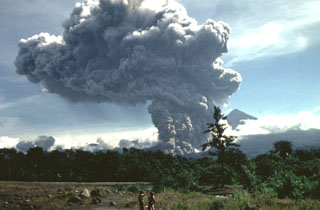 A large pyroclastic flow travels down the flank of the Santiaguito lava dome on 19 July 1989. The pyroclastic flow and ash plume are seen here from just west of El Palmar (10 km S of the dome) about 5 minutes after the start of the explosion. The Santa María summit is visible to the right of the plume, which rose to 4 km above the vent. The pyroclastic flow traveled 5 km down the Río Nimá and was one of the larger events since the major 1929-34 activity.
 An ash plume rises above the Santiaguito lava dome complex in June 1976 nearly to the height of Santa María's summit. The dome complex was constructed within a large explosion crater that formed in the SW flank of during the major 1902 explosive eruption. The crater, seen in profile here, extends from just below the summit to 2.2 km elevation, below the bottom of the photo.
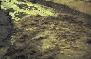 The advancing front of a lahar travels down the Río Nimá Segundo below the Santiaguito lava dome complex on 14 August 1989. Sediment yields in drainages below the Santa Maria’s active domes are extremely high, and rainy season lahars frequently impact areas downstream.
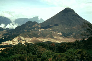 Santa Maria is seen here from Siete Orejas volcano. The SW (right-hand) flank of Santa María is slightly influenced by the profile of the massive crater produced by the 1902 eruption. The forested peak on the lower NE flank of Santa María is Volcán del Valle, an eroded scoria cone. Behind it is Santo Tomás volcano. Light-colored pumice deposits from the 1902 Santa María eruption and a Pleistocene eruption of Siete Orejas volcano are visible in the foreground.
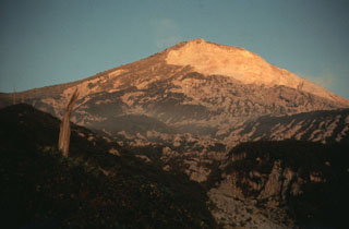 The Santa María western flank of is seen here at sunset. The light-colored area to the upper right is the upper headwall of the 1902 explosion crater across the SW flank. Pumice deposits from the 1902 eruption are visible across the flanks, exceeding 15 m in thickness.
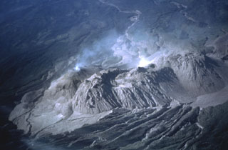 The four major domes of the Santiaguito complex are seen here from the summit of Santa María in 1980. Caliente is degassing to the left, with La Mitad and El Monje in the center, and El Brujo to the right. The dacite dome complex stretches about 3 km in a roughly E-W direction. Lava flows and lahar channels extend down drainages from the dome complex to the south.
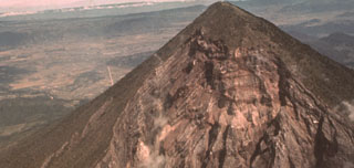 The catastrophic 1902 Santa María eruption formed a massive 1.5-km-wide crater in the SW flank. The upper part of the crater wall, which extends nearly to the summit of Santa María, is seen here from the SW. Guatemala's second largest city, Quetzaltenango, lies in the basin visible to the left, 10 km to the NNE. The 1902 eruption took place after a long period of quiescence that followed construction of the edifice.
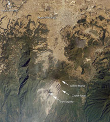 Santa María, located south of the city Quetzaltenango, is one of the country's most active volcanoes. The Santiaguito lava dome complex was constructed within a large crater formed during the 1902 eruption. The unvegetated lava flow above and to the right of Santa María was erupted from Cerro Quemado, part of the Almolonga volcanic complex, which also includes the series of lava domes to the north of Cerro Quemado. The large forested valley to the left is part of Siete Orejas volcano.
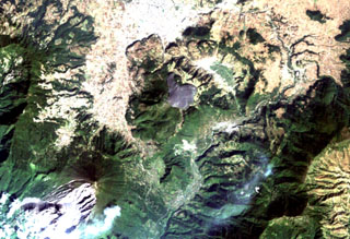 The arcuate area at the top center below the light-colored city of Quetzaltenango is the Almolonga volcanic complex. An arcuate series of lava domes outlines the northern part of the complex, while the unvegetated area to the south is the 1818 lava flow from Cerro Quemado volcano, the youngest of the Almolonga complex. Almolonga is located along the Zunil fault zone, which extends diagonally SW along the Río Samalá (bottom-center). The furrowed 1902 crater of Santa María volcano lies at the lower left.
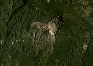 Santa Maria is the large edifice with the broad 1902 crater in the center of this August 2019 Planet Labs satellite image monthly mosaic (N is at the top; this image is approximately 12 km across). The Santiaguito dome complex in comprised of Caliente, the large lava dome in the center of the image, then La Mitad, El Monje, and El Brujo domes from E to W.
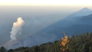 This February 2017 view of El Caliente of the Santiaguito lava dome complex is from the Santa Maria summit (producing the shadow to the right). The other Santiaguito domes visible from left to right (approximately NE-SW) are El Caliente, La Mitad, El Monje, and El Brujo. El Caliente is degassing through its characteristic ring-shaped fracture network.
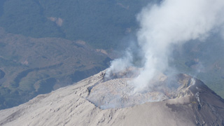 This 28 February 2017 photograph of El Caliente dome summit shows that the dome had nearly filled the crater. Pyroclastic flows from El Caliente are often caused by the partial collapse of an overflowing dome. Weak degassing is visible from the center and perimeter of the dome. Blocky lava flows produced from El Caliente vent are visible in the background.
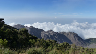 This view from the lookout point on the W flank of Santa Maria shows the Santiaguito dome complex on 27 February 2020. From left to right (approximately NE-SW) the domes are El Caliente, La Mitad, El Monje, and El Brujo.
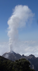 This view of El Caliente dome from the lookout point on the W flank of Santa Maria shows moderate degassing forming a vertical gas plume. The dome is part of the Santiaguito dome complex with the other domes to the right.
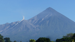 A rockfall descends the S flank of the Caliente dome of the Santiaguito dome complex at Santa Maria volcano on 28 February 2020, causing a small ash plume to rise above it. The Santa Maria edifice is behind and just right of the dome, with the large 1902 crater wall extending down its SW flank.
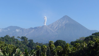 This 28 February 2020 photo shows typical degassing at El Caliente dome producing a vertical gas plume. The dome is one of four that form the Santiaguito dome complex at Santa Maria, with the 1902 crater wall behind it.
The following 14 samples associated with this volcano can be found in the Smithsonian's NMNH Department of Mineral Sciences collections, and may be availble for research (contact the Rock and Ore Collections Manager). Catalog number links will open a window with more information.
| Catalog Number | Sample Description | Lava Source | Collection Date |
|---|---|---|---|
| NMNH 113100-1 | Pumice | SANTIAGUITO | -- |
| NMNH 113100-10 | Pumice | -- | -- |
| NMNH 113100-11 | Pumice | -- | -- |
| NMNH 113100-2 | Dacite | SANTIAGUITO | -- |
| NMNH 113100-3 | Igneous Rock | -- | -- |
| NMNH 113100-4 | Pumice | -- | -- |
| NMNH 113100-5 | Pumice | -- | -- |
| NMNH 113100-6 | Pumice | -- | -- |
| NMNH 113100-7 | Pumice | -- | -- |
| NMNH 113100-8 | Pumice | -- | -- |
| NMNH 113100-9 | Pumice | -- | -- |
| NMNH 75266 | Volcanic Ash | -- | -- |
| NMNH 76973 | Volcanic Ash | -- | -- |
| NMNH 76974 | Volcanic Ash | -- | -- |
| Copernicus Browser | The Copernicus Browser replaced the Sentinel Hub Playground browser in 2023, to provide access to Earth observation archives from the Copernicus Data Space Ecosystem, the main distribution platform for data from the EU Copernicus missions. |
| MIROVA | Middle InfraRed Observation of Volcanic Activity (MIROVA) is a near real time volcanic hot-spot detection system based on the analysis of MODIS (Moderate Resolution Imaging Spectroradiometer) data. In particular, MIROVA uses the Middle InfraRed Radiation (MIR), measured over target volcanoes, in order to detect, locate and measure the heat radiation sourced from volcanic activity. |
| MODVOLC Thermal Alerts | Using infrared satellite Moderate Resolution Imaging Spectroradiometer (MODIS) data, scientists at the Hawai'i Institute of Geophysics and Planetology, University of Hawai'i, developed an automated system called MODVOLC to map thermal hot-spots in near real time. For each MODIS image, the algorithm automatically scans each 1 km pixel within it to check for high-temperature hot-spots. When one is found the date, time, location, and intensity are recorded. MODIS looks at every square km of the Earth every 48 hours, once during the day and once during the night, and the presence of two MODIS sensors in space allows at least four hot-spot observations every two days. Each day updated global maps are compiled to display the locations of all hot spots detected in the previous 24 hours. There is a drop-down list with volcano names which allow users to 'zoom-in' and examine the distribution of hot-spots at a variety of spatial scales. |
|
WOVOdat
Single Volcano View Temporal Evolution of Unrest Side by Side Volcanoes |
WOVOdat is a database of volcanic unrest; instrumentally and visually recorded changes in seismicity, ground deformation, gas emission, and other parameters from their normal baselines. It is sponsored by the World Organization of Volcano Observatories (WOVO) and presently hosted at the Earth Observatory of Singapore.
GVMID Data on Volcano Monitoring Infrastructure The Global Volcano Monitoring Infrastructure Database GVMID, is aimed at documenting and improving capabilities of volcano monitoring from the ground and space. GVMID should provide a snapshot and baseline view of the techniques and instrumentation that are in place at various volcanoes, which can be use by volcano observatories as reference to setup new monitoring system or improving networks at a specific volcano. These data will allow identification of what monitoring gaps exist, which can be then targeted by remote sensing infrastructure and future instrument deployments. |
| Volcanic Hazard Maps | The IAVCEI Commission on Volcanic Hazards and Risk has a Volcanic Hazard Maps database designed to serve as a resource for hazard mappers (or other interested parties) to explore how common issues in hazard map development have been addressed at different volcanoes, in different countries, for different hazards, and for different intended audiences. In addition to the comprehensive, searchable Volcanic Hazard Maps Database, this website contains information about diversity of volcanic hazard maps, illustrated using examples from the database. This site is for educational purposes related to volcanic hazard maps. Hazard maps found on this website should not be used for emergency purposes. For the most recent, official hazard map for a particular volcano, please seek out the proper institutional authorities on the matter. |
| IRIS seismic stations/networks | Incorporated Research Institutions for Seismology (IRIS) Data Services map showing the location of seismic stations from all available networks (permanent or temporary) within a radius of 0.18° (about 20 km at mid-latitudes) from the given location of Santa María. Users can customize a variety of filters and options in the left panel. Note that if there are no stations are known the map will default to show the entire world with a "No data matched request" error notice. |
| UNAVCO GPS/GNSS stations | Geodetic Data Services map from UNAVCO showing the location of GPS/GNSS stations from all available networks (permanent or temporary) within a radius of 20 km from the given location of Santa María. Users can customize the data search based on station or network names, location, and time window. Requires Adobe Flash Player. |
| DECADE Data | The DECADE portal, still in the developmental stage, serves as an example of the proposed interoperability between The Smithsonian Institution's Global Volcanism Program, the Mapping Gas Emissions (MaGa) Database, and the EarthChem Geochemical Portal. The Deep Earth Carbon Degassing (DECADE) initiative seeks to use new and established technologies to determine accurate global fluxes of volcanic CO2 to the atmosphere, but installing CO2 monitoring networks on 20 of the world's 150 most actively degassing volcanoes. The group uses related laboratory-based studies (direct gas sampling and analysis, melt inclusions) to provide new data for direct degassing of deep earth carbon to the atmosphere. |
| Large Eruptions of Santa María | Information about large Quaternary eruptions (VEI >= 4) is cataloged in the Large Magnitude Explosive Volcanic Eruptions (LaMEVE) database of the Volcano Global Risk Identification and Analysis Project (VOGRIPA). |
| EarthChem | EarthChem develops and maintains databases, software, and services that support the preservation, discovery, access and analysis of geochemical data, and facilitate their integration with the broad array of other available earth science parameters. EarthChem is operated by a joint team of disciplinary scientists, data scientists, data managers and information technology developers who are part of the NSF-funded data facility Integrated Earth Data Applications (IEDA). IEDA is a collaborative effort of EarthChem and the Marine Geoscience Data System (MGDS). |

