Report on Chiles-Cerro Negro (Colombia-Ecuador) — 15 October-21 October 2014
Smithsonian Institution / US Geological Survey
Weekly Volcanic Activity Report, 15 October-21 October 2014
Managing Editor: Sally Sennert.
Please cite this report as:
Global Volcanism Program, 2014. Report on Chiles-Cerro Negro (Colombia-Ecuador) (Sennert, S, ed.). Weekly Volcanic Activity Report, 15 October-21 October 2014. Smithsonian Institution and US Geological Survey.
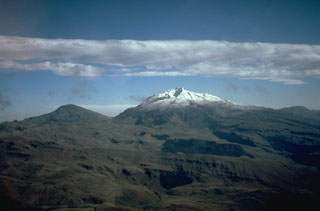
Chiles-Cerro Negro
Colombia-Ecuador
0.817°N, 77.938°W; summit elev. 4698 m
All times are local (unless otherwise noted)
On 20 October Servicio Geológico Colombiano (SGC) reported that a M 5.8 earthquake, the largest to date, occurred in the vicinity of the Cerro Negro de Mayasquer and Chiles volcanoes at a depth of less than 10 km. The event was felt to the N in Pasto (Colombia) and to the S in Quito (Ecuador). On 21 October SGC raised the Alert Level for the volcanic complex to Orange (level 3 of 4) noting that a seismic swarm characterized by 4,300 earthquakes was detected in an 18-hour period. Hypocenters were located 1-4 km SW of Chiles volcano at depths of 3-5 km and local magnitudes between M 0.2 and 4.5. Inhabitants felt 11 of the events. On 22 October a report noted that the total number of earthquakes recorded on 21 October reached 7,717, which was the largest number of earthquakes recorded on one day since the installation of a local seismic network in November 2013. Several swarms have occurred in the area since February 2013.
Geological Summary. The Chiles-Cerro Negro volcanic complex includes both the Pleistocene Chiles and the Cerro Negro de Mayasquer stratovolcanoes astride the Colombia-Ecuador border. Cerro Negro has a caldera open to the west, with andesitic and dacitic lava flows of possible Holocene age (Hall 1992, pers. comm.) and solfataras on the shore of a small crater lake. An eruption reported in 1936 may have been from Reventador (Catalog of Active Volcanoes of the World). The higher, glacier-covered summit of Chiles, about 4 km ESE of Cerro Negro, last erupted about 160,000 years ago, but it has a caldera open to the north with hot springs and an active hydrothermal system on its eastern flank.