
Smithsonian Institution / US Geological Survey
Weekly Volcanic Activity Report, 8 September-14 September 2021
Managing Editor: Sally Sennert
Please cite this report as:
Global Volcanism Program, 2021. Report on Lewotolok (Indonesia) (Sennert, S, ed.). Weekly Volcanic Activity Report, 8 September-14 September 2021. Smithsonian Institution and US Geological Survey. https://volcano.si.edu/showreport.cfm?gvpvar=GVP.WVAR20210908-264230
PVMBG reported that the eruption at Lewotolok continued during 7-14 September. White-and-gray plumes rose as high as 700 m above the summit and drifted NWW, SW, and S. The Alert Level remained at 3 (on a scale of 1-4) and the public was warned to stay 3 km away from the summit crater.
Source: Pusat Vulkanologi dan Mitigasi Bencana Geologi (PVMBG, also known as CVGHM)
Geological Summary. The Lewotolok (or Lewotolo) stratovolcano occupies the eastern end of an elongated peninsula extending north into the Flores Sea, connected to Lembata (formerly Lomblen) Island by a narrow isthmus. It is symmetrical when viewed from the north and east. A small cone with a 130-m-wide crater constructed at the SE side of a larger crater forms the volcano's high point. Many lava flows have reached the coastline. Eruptions recorded since 1660 have consisted of explosive activity from the summit crater.


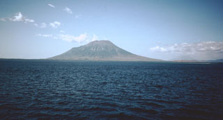 Lewotolok