Report on Tofua (Tonga) — 22 May-28 May 2024
Smithsonian Institution / US Geological Survey
Weekly Volcanic Activity Report, 22 May-28 May 2024
Managing Editor: Sally Sennert.
Please cite this report as:
Global Volcanism Program, 2024. Report on Tofua (Tonga) (Sennert, S, ed.). Weekly Volcanic Activity Report, 22 May-28 May 2024. Smithsonian Institution and US Geological Survey.
Tofua
Tonga
19.75°S, 175.07°W; summit elev. 515 m
All times are local (unless otherwise noted)
At 0900 on 23 May Tonga Geological Services reported that elevated activity at Tofua had ceased during the previous week. The characteristics of a thermal anomaly identified in a satellite image indicated a return to baseline levels. The Aviation Color Code was lowered to Green (the lowest color on a four-color scale), the Maritime Alert Level was lowered to Green (the lowest level on a four-color scale), and the Alert level for residents of Vava’u and Ha’apai remained at Green (the lowest color on a four-color scale).
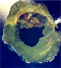
Geological Summary. The low, forested Tofua Island in the central part of the Tonga Islands group is the emergent summit of a large stratovolcano that was seen in eruption by Captain Cook in 1774. The summit contains a 5-km-wide caldera whose walls drop steeply about 500 m. Three post-caldera cones were constructed at the northern end of a cold fresh-water caldera lake, whose surface lies only 30 m above sea level. The easternmost cone has three craters and produced young basaltic andesite lava flows, some of which traveled into the caldera lake. The largest and northernmost of the cones, Lofia, has a steep-sided crater that is 70 m wide and 120 m deep and has been the source of historical eruptions, first reported in the 18th century. The fumarolically active crater of Lofia has a flat floor formed by a ponded lava flow.