Report on Lopevi (Vanuatu) — July 1991
Bulletin of the Global Volcanism Network, vol. 16, no. 7 (July 1991)
Managing Editor: Lindsay McClelland.
Lopevi (Vanuatu) No fumarolic activity
Please cite this report as:
Global Volcanism Program, 1991. Report on Lopevi (Vanuatu) (McClelland, L., ed.). Bulletin of the Global Volcanism Network, 16:7. Smithsonian Institution. https://doi.org/10.5479/si.GVP.BGVN199107-257050
Lopevi
Vanuatu
16.507°S, 168.346°E; summit elev. 1413 m
All times are local (unless otherwise noted)
"The volcano was totally quiet during overflights (VANAIR) on 4 September 1990, and 13 and 24 July 1991. . . . As with Gaua, the scarcity of information from 1977 to 1989 prevents a precise description of its activity. Nevertheless, it seems that no major event occurred during this period."
[The Bulletin of Volcanic Eruptions (BVE) reports lava flows in November 1978, ash eruptions and lava flows February-March 1979, a black eruption column on 2 July 1979, minor ash emissions on 12 September 1979, vigorous ash eruptions in April and July 1980, and an eruption cloud and lava flow on 18-20 August 1980.]
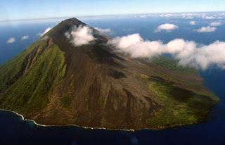
Geological Summary. The small 7-km-wide conical island of Lopevi, known locally as Vanei Vollohulu, is one of Vanuatu's most active volcanoes. A small summit crater containing a cinder cone is breached to the NW and tops an older cone that is rimmed by the remnant of a larger crater. The basaltic-to-andesitic volcano has been active during historical time at both summit and flank vents, primarily along a NW-SE-trending fissure that cuts across the island, producing moderate explosive eruptions and lava flows that reached the coast. Historical eruptions at the 1413-m-high volcano date back to the mid-19th century. The island was evacuated following major eruptions in 1939 and 1960. The latter eruption, from a NW-flank fissure vent, produced a pyroclastic flow that swept to the sea and a lava flow that formed a new peninsula on the western coast.
Information Contacts: C. Robin and M. Monzier, ORSTOM, New Caledonia; M. Lardy and C. Douglas, ORSTOM,Vanuatu; C. Mortimer, Dept of Geology, Mines, and Rural Water Supply,Vanuatu; J. Eissen, ORSTOM, France.

