Report on Agung (Indonesia) — August 2018

Bulletin of the Global Volcanism Network, vol. 43, no. 8 (August 2018)
Managing Editor: Edward Venzke.
Edited by A. Elizabeth Crafford.
Agung (Indonesia) Ash explosions and lava dome effusion continue during January-July 2018
Please cite this report as:
Global Volcanism Program, 2018. Report on Agung (Indonesia) (Crafford, A.E., and Venzke, E., eds.). Bulletin of the Global Volcanism Network, 43:8. Smithsonian Institution. https://doi.org/10.5479/si.GVP.BGVN201808-264020
Agung
Indonesia
8.343°S, 115.508°E; summit elev. 2997 m
All times are local (unless otherwise noted)
After a large, deadly explosive and effusive eruption during 1963-64, Indonesia's Mount Agung was quiet until a new eruption began in November 2017 (BGVN 43:01). A lava dome emerged into the summit crater at the end of November and intermittent plumes of ash rose as high as 3 km above the summit through the end of the year. Activity continued into 2018 with explosions that produced ash plumes rising multiple kilometers above the summit, and the growth of the lava dome within the summit crater. Information about the ongoing eruptive episode comes from Pusat Vulkanologi dan Mitigasi Bencana Geologi (PVMBG), also known as the Indonesian Center for Volcanology and Geological Hazard Mitigation (CVGHM), the Darwin Volcanic Ash Advisory Center (VAAC), and multiple sources of satellite data. This report covers the ongoing eruption from January through July 2018.
Intermittent explosions with ash plumes were reported at Agung several times during January 2018, including Strombolian activity on 19 January. Activity decreased significantly by the end of the month; only one explosion with ash was reported during February. Two ash plumes were reported in March and three were reported each month during April and May. A more substantial explosion in mid-June produced an ash plume that rose to 7 km altitude. A series of deep-seated earthquakes during the third week of June was followed by large explosions and new effusions of lava inside the summit crater beginning on 28 June. A strong thermal signal also appeared on 28 June that gradually diminished during July. Intermittent plumes of steam and ash recurred daily until 19 July; plume heights rose up to 3 km above the summit on several occasions. Strombolian explosions on 2 and 8 July sent ejecta as far as 2 km from the summit. Explosive activity became more intermittent during the last two weeks of the month; the last reported explosion was on 27 July.
Activity during January-May 2018. During most days of January 2018 when fog was not obscuring the summit, PVMGB reported plumes of steam and minor ash rising about 500 m above the summit. In addition, intermittent explosions produced higher, denser ash plumes that rose 1,000-2,500 m above the summit several times. Ash plumes on 1 and 2 January rose to 1,000 and 1,500 m above the summit; incandescence was observed at the summit on both nights, and trace ashfall was reported at the Rendang Post on 2 January. The Darwin VAAC reported the ash plume on 1 January at 6.1 km altitude moving SW. A single MODVOLC thermal alert was recorded on 4 January. On 5 January PVMGB lowered the evacuation radius from 10 to 6 km, permitting the return of thousands of displaced people to their homes. Approximately 17,000 people in seven villages within 6 km of Agung were still under evacuation orders from the events of late 2017.
The Agung Volcano Observatory issued VONA's (Volcano Observatory Notice for Aviation) on 4, 8, 9, 11, 15, 17, 19, 23, 24, and 30 January relating to the larger explosions and ash plumes. On 11 January, an ash plume rose to 2,500 m above the summit and drifted N and NE (figure 29). Another 2,500-m-high ash plume on 19 January was accompanied by Strombolian activity at the summit for several hours, and incandescent ejecta that traveled 1,000 m from the crater. Ashfall was later reported in Tulamben village in the Kubu district (9 km NE) and in Purwekerti village in the Abang district (14 km ENE). Visual monitoring using drones carried out on 22 January showed that the volume of the lava dome was relatively unchanged at around 20 million m3. The summit was obscured by fog for the last week of the month.
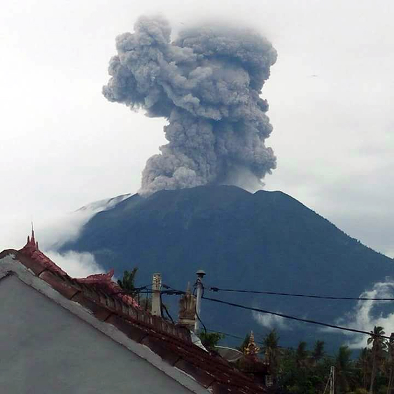 |
Figure 29. An eruption at Agung on 11 January 2018 sent an ash plume to 2,500 m above the summit. Courtesy of MAGMA Indonesia and PVMBG (Erupsi Gunung Agung 11 Januari 2018 17:54 WITA). |
Activity decreased noticeably in late January and February. Steam and minor ash plumes rose only 50-800 m above the summit for most of the month. As a result of the decrease in activity, PVMBG lowered the Alert Level from Level IV to Level III (on a four-level scale) on 10 February 2018. The radius of evacuation was also lowered from 6 to 4 km. A single explosion on 14 February sent an ash plume to 1,500 m above the summit.
For most of March 2018, steam plumes rose less than 400 m above the summit. VONA's were issued by the Agung Volcano Observatory for ash plumes twice, on 12 March (local time) when a plume rose 800 m above the summit and drifted E, and on 26 March when the ash plume rose to 500 m and drifted NW. During much of April 2018, steam plumes rose less than 300 m above the summit; weather obscured views of the summit for most of the last week of the month. AVO issued VONA's for ash plumes on 6, 11 and 30 April; the plumes on 6 and 11 April rose 500 m and drifted W and SW respectively. The Darwin VAAC reported a series of four short-lived explosions with ash plumes on 11 April; they each dissipated within a few hours. PVMBG reported another explosion on 15 April that produced an ash plume that also rose 500 m. The plume on 30 April rose 1,500 m and drifted SW.
Similar activity persisted throughout May 2018. Steam plumes generally rose 50-100 m above the summit crater each day. In addition, explosions were reported on 9, 19, and 29 May. PVMBG reported that no ash plume was observed on 9 May, due to fog obscuring the summit, but the ash plume on 19 May rose to 1,000 m above the summit and drifted SE, and the ash plume on 29 May rose 500 m and drifted SW.
Activity during June and July 2018. The volcano was covered in fog for much of the first two weeks of June. A short-lived explosion on 10 June 2018 was reported by PVMBG, but meteoric clouds obscured the summit. The Darwin VAAC noted the plume in a satellite image drifting W at about 4.6 km altitude. An explosion on 13 June produced an ash plume that rose 2,000 m above the summit and drifted WSW (figure 30). Another explosion was recorded on 15 June, but the summit was obscured, and no ash cloud was visible to ground observers. However, the Darwin VAAC reported the plume visible in satellite imagery at 7 km altitude (about 4 km above the summit) drifting SW and S for most of the day before dissipating. Ashfall was reported about 7 km W in the village of Puregai. PVMBG reported white and gray emissions on 17 June that rose 500 m.
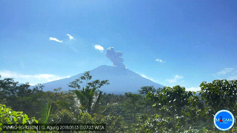 |
Figure 30. An ash plume at Agung on 13 June 2018 rose about 2,000 m above the summit and drifted WSW. View is looking N. Courtesy of PVMBG (Information on G. Agung Eruption, 13 June 2018). |
An explosion during the evening (local time) of 27 June 2018 produced an ash plume that rose 2,000 m from the summit and drifted W. Another explosion the following morning produced a sustained ash cloud that lasted for several hours and again caused ashfall around the village of Puregai. It rose to about 2,000 m above the summit and drifted W and SW (figure 31).
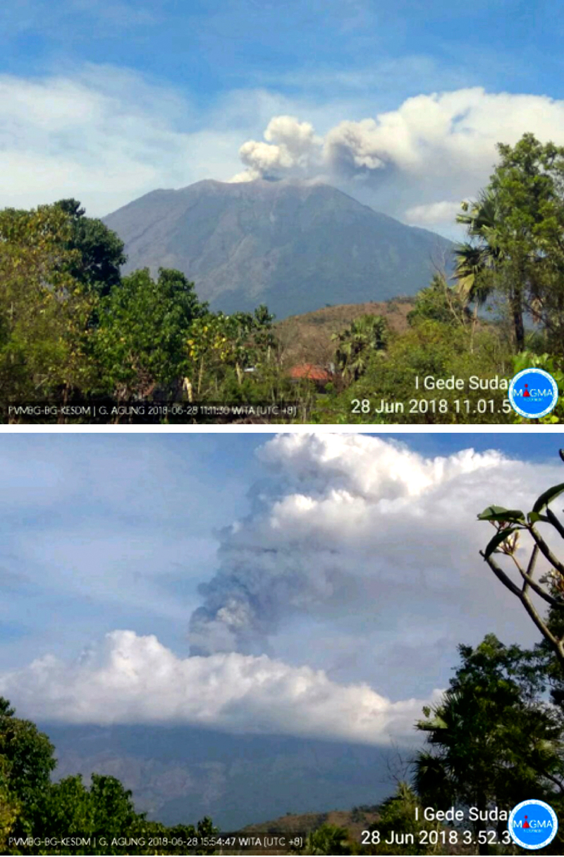 |
Figure 31. A sustained ash eruption began early on 28 June 2018 at Agung (top) and lasted well into the afternoon (bottom). Photo from a PBVBG webcam, posted on Twitter by Sutopo Purwo Nugroho (BNPB). |
PVMBG noted in late June that inflation of 5 mm had occurred since 13 May 2018. They reported that the ash plumes on 28 June caused some airlines to cancel flights to Bali, and ashfall was reported in several villages in Bangli and areas to the W and SW the following day (figure 32). The International Gusti Ngurah Rai (IGNR) airport (60 km SW) in Denpasar, the Blimbing Sari Airport (128 km W) in Banyuwangi, and the Noto Hadinegoro Airport (200 km W) in Jember closed for portions of the day on 29 June (ANTARA News).
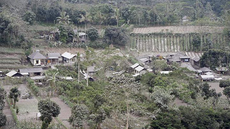 |
Figure 32. Settlement and plantation areas were coated with ash from Mount Agung in Pemuteran Village (10 km W) on 29 June 2018. Courtesy of Tempo.com and ANTARA/Nyoman Budhiana. |
Incandescence overnight on 28-29 June indicated fresh effusions of lava at the summit; they were accompanied by ash emissions that rose 1,500-2,500 m. Thermal satellite images recorded on 29 June indicated significant hotspots within the crater with thermal energy reaching 819 Megawatts; this was the largest amount of thermal energy recorded during the 2017-2018 activity, significantly higher than the maximum recorded of 97 Megawatts reached at the end of November 2017. The MIROVA data clearly reflected the sudden surge of thermal energy into the summit crater at the end of June (figure 33).
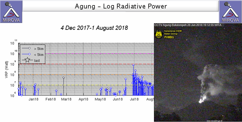 |
Figure 33. A large spike in thermal energy beginning on 28 June 2018 signaled a new surge of lava into the summit crater at Agung. This MIROVA plot of Log Radiative Power showed pulses of activity in early January, May, and early June, followed by the much larger surge of heat in late June that tapered off throughout July. Inset shows the nighttime incandescence on 28 June 2018 that resulted from the new effusion of lava. Photo taken at the PGMBG Webcam in Batu Lompeh (15 km N). Graph courtesy of MIROVA, photo courtesy of PVMBG (Press Release of Mount Agung's Latest Activities, June 29 to 3:00 p.m.) |
The Darwin VAAC reported continuous emissions of ash beginning on 28 June that drifted to the W for over 24 hours. The height was initially reported by ground observers at 3.7 km altitude but was raised to 7 km altitude a few hours later, based on satellite imagery and pilot reports. By late that day, an upper plume (at 7 km) drifted SW and a second plume drifted W at 5.5 km altitude. By late on 29 June the continuous ash plume was drifting NW at 4.9 km altitude; it finally dissipated early on 30 June. In addition to large ash plumes and a major thermal anomaly, a substantial SO2 plume also emerged from Agung on 28-29 June 2018. The plume drifted W over Java and then dispersed to the NW over the next 24 hours (figure 34). A lingering, smaller plume was still visible two days later.
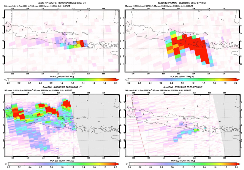 |
Figure 34. A substantial SO2 plume was released from Agung during 28-29 June 2018 and captured by both the OMPS instrument on the Suomi satellite (upper images) and the OMI instrument on the Aura satellite (lower images). The plume first appeared on 28 June (top left) and was much larger the next day (top right). By 30 June it was dissipating over Java to the W and N (bottom left). A smaller plume drifted SW two days later (bottom right). Courtesy of NASA Goddard Space Flight Center. |
A series of discrete eruptions lasting from late on 30 June through 2 July 2018 produced ash plumes that rose from 3.7 to 5.5 km altitude and drifted NW and W, according to the Darwin VAAC. Effusive activity continued to increase during the first week of July 2018 with the continued growth of the lava dome in the summit crater. PVMBG reported an additional volume of lava of 4 million m3 erupted from 28 June through the middle of July bringing the size of the dome to about 27 million m3. The frequency of explosions peaked on 2 July when Strombolian activity sent incandescent ejecta 2 km from the summit in all directions (figure 35).
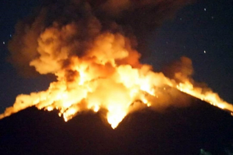 |
Figure 35. The eruption of Mount Agung on 2 July 2017 produced Strombolian activity and incandescent ejecta that traveled 2 km from the summit crater in all directions. Courtesy of ANTARA News/HO/BMKG. |
Several VONA's issued during 2-3 July reported multiple explosions that sent ash plumes 700-2,000 m above the summit. Eighteen explosions were reported by PVMBG between 1 and 8 July. The Darwin VAAC noted a substantial explosion early on 2 July that produced a plume that rose to 7.6 km altitude and drifted W. The remains of the ash plume were discernable in satellite imagery about 250 km W of Agung by the end of the day. The ash plume on 4 July rose 2,500 m above the summit (figure 36).
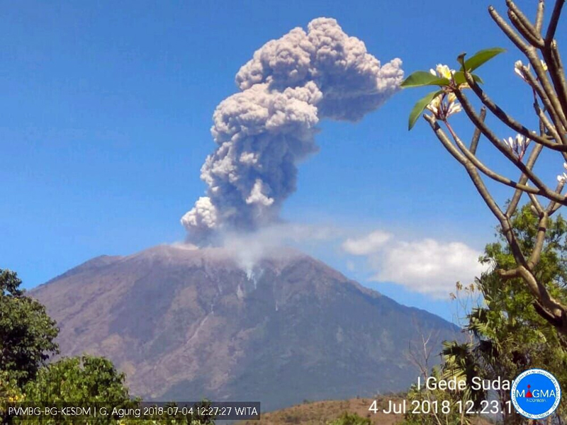 |
Figure 36. An explosion at Agung on 4 July 2018 produced an ash plume that rose 2,500 m above the summit, according to PVMBG. Courtesy of PVMBG (Information on G. Agung Eruption, July 4, 2018). |
Strombolian activity was reported again on 8 July 2018 (figure 37). The Darwin VAAC reported intermittent explosions every day from 3-19 July, with ash plumes rising to altitudes from 3.7 to 6.7 km. Additional explosions were reported on 21, 24, 25, and 27 July (figure 38); ash plumes rose 700-2,000 m and drifted W or SE. MODVOLC thermal alerts resumed on 27 June, and multiple daily alerts persisted on most days through the end of July.
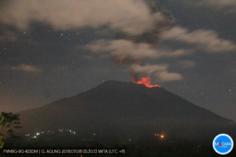 |
Figure 37. Strombolian activity at Agung recurred for the third time in 2018 on 8 July 2018. Courtesy of PVMBG (Agung Strombolian Eruption Today July 8, 2018). |
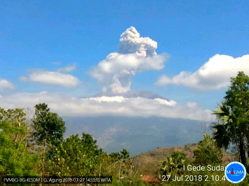 |
Figure 38. A dense ash plume rose about 2,000 m above Mount Agung on 27 July 2018 at 1406 local time. Courtesy of PVMBG (Information on G. Agung Eruption, 27 July 2018). |
Geological Summary. Symmetrical Agung stratovolcano, Bali's highest and most sacred mountain, towers over the eastern end of the island. The volcano, whose name means "Paramount," rises above the SE rim of the Batur caldera, and the northern and southern flanks extend to the coast. The summit area extends 1.5 km E-W, with the high point on the W and a steep-walled 800-m-wide crater on the E. The Pawon cone is located low on the SE flank. Only a few eruptions dating back to the early 19th century have been recorded in historical time. The 1963-64 eruption, one of the largest in the 20th century, produced voluminous ashfall along with devastating pyroclastic flows and lahars that caused extensive damage and many fatalities.
Information Contacts: Pusat Vulkanologi dan Mitigasi Bencana Geologi (PVMBG, also known as Indonesian Center for Volcanology and Geological Hazard Mitigation, CVGHM), Jalan Diponegoro 57, Bandung 40122, Indonesia (URL: http://www.vsi.esdm.go.id/); MAGMA Indonesia, Kementerian Energi dan Sumber Daya Mineral (URL: https://magma.vsi.esdm.go.id/); Darwin Volcanic Ash Advisory Centre (VAAC), Bureau of Meteorology, Northern Territory Regional Office, PO Box 40050, Casuarina, NT 0811, Australia (URL: http://www.bom.gov.au/info/vaac/); MIROVA (Middle InfraRed Observation of Volcanic Activity), a collaborative project between the Universities of Turin and Florence (Italy) supported by the Centre for Volcanic Risk of the Italian Civil Protection Department (URL: http://www.mirovaweb.it/); Hawai'i Institute of Geophysics and Planetology (HIGP) - MODVOLC Thermal Alerts System, School of Ocean and Earth Science and Technology (SOEST), Univ. of Hawai'i, 2525 Correa Road, Honolulu, HI 96822, USA (URL: http://modis.higp.hawaii.edu/); NASA Goddard Space Flight Center (NASA/GSFC), Global Sulfur Dioxide Monitoring Page, Atmospheric Chemistry and Dynamics Laboratory, 8800 Greenbelt Road, Goddard, Maryland, USA (URL: https://so2.gsfc.nasa.gov/); Sutopo Purwo Nugroho?, BNPB, Twitter (URL: https://twitter.com/Sutopo_PN); TEMPO.CO, Tempo Building, Jl. Palmerah Barat No. 8, South Jakarta 12210, Indonesia (URL: https://nasional.tempo.co/read/1102118/pvmbg-energi-thermal-erupsi-gunung-agung-kali-ini-paling-besar); ANTARANEWS.com, ANTARA guesthouse lt 19, Jalan Merdeka Selatan No. 17, Jakarta Pusat, Indonesia, (URL: https://en.antaranews.com).