Report on Dukono (Indonesia) — December 2023
Bulletin of the Global Volcanism Network, vol. 48, no. 12 (December 2023)
Managing Editor: Edward Venzke.
Research and preparation by Berger.
Dukono (Indonesia) Continuing SO2 plumes and thermal anomalies; strong ash emissions in October-November 2023
Please cite this report as:
Global Volcanism Program, 2023. Report on Dukono (Indonesia) (Venzke, E., ed.). Bulletin of the Global Volcanism Network, 48:12. Smithsonian Institution.
Dukono
Indonesia
1.6992°N, 127.8783°E; summit elev. 1273 m
All times are local (unless otherwise noted)
Dukono, a remote volcano on Indonesia’s Halmahera Island, has been erupting continuously since 1933, with frequent ash explosions and sulfur dioxide plumes (BGVN 48:06). This activity continued during June-November 2023, based on reports from the Pusat Vulkanologi dan Mitigasi Bencana Geologi (PVMBG; also known as Indonesian Center for Volcanology and Geological Hazard Mitigation, CVGHM), the Darwin Volcanic Ash Advisory Centre (VAAC), and satellite data.
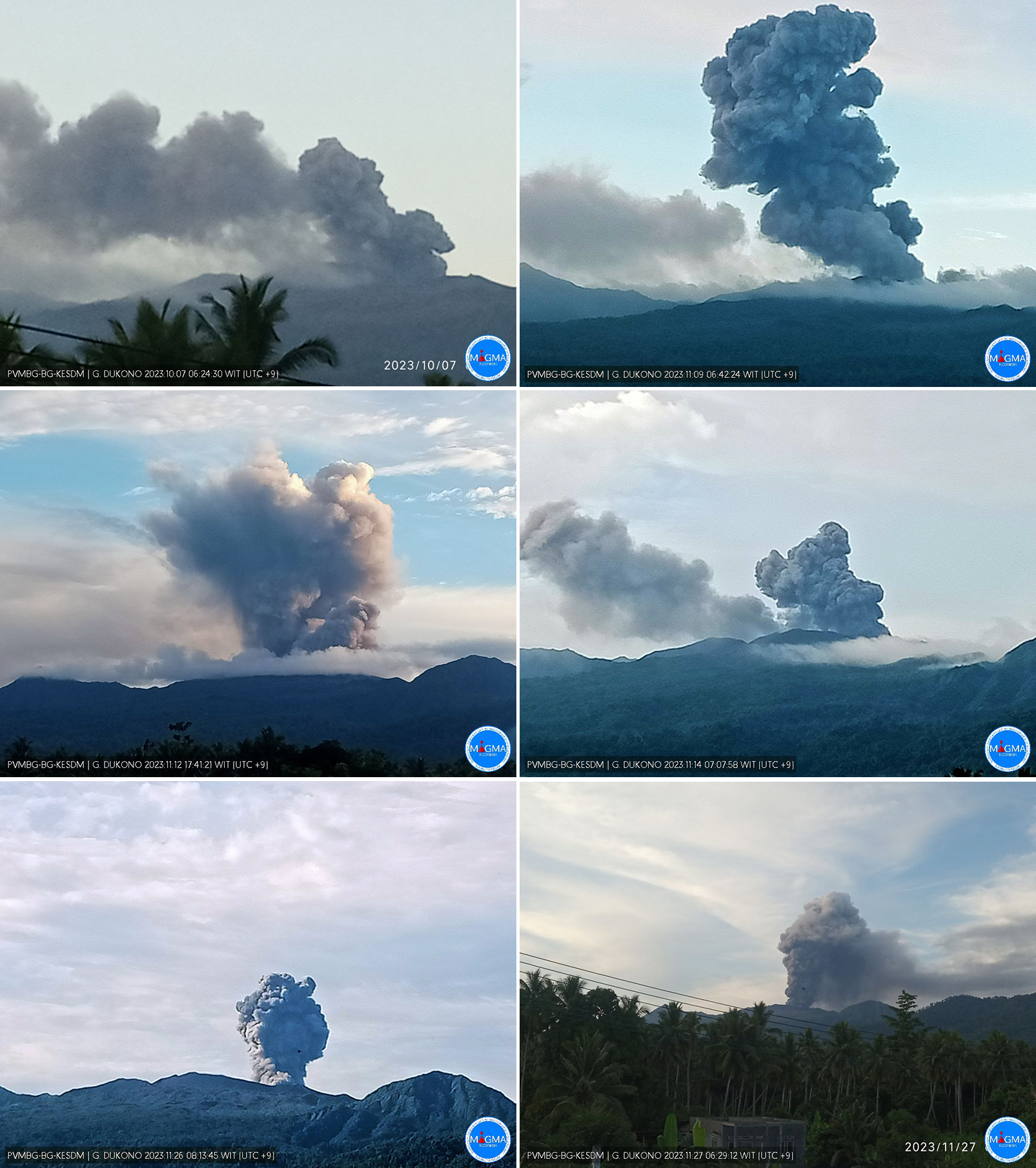
Webcam photos posted to MAGMA Indonesia (a platform developed by PVMBG) showed that, white, gray, or dark plumes of variable densities were observed almost every day during the reporting period (figure 35), except when fog obscured the volcano. Plume heights ranged up to 2,500 m above the summit. Images during 7 October-27 November 2023. During the first week of November ashfall up to 0.5 mm thick fell in several areas downwind, including Mede, Popilo, Gorua (4.5 km ENE), Waro ino-Weri, Buwaele, Gura, Cina, Gamsungi, and Tobelo (15 km ENE). Banging noises were also heard several times in the same villages.
 |
Figure 35. Webcam photos of Dukono showing ash plumes during October-November 2023. Courtesy of MAGMA Indonesia. |
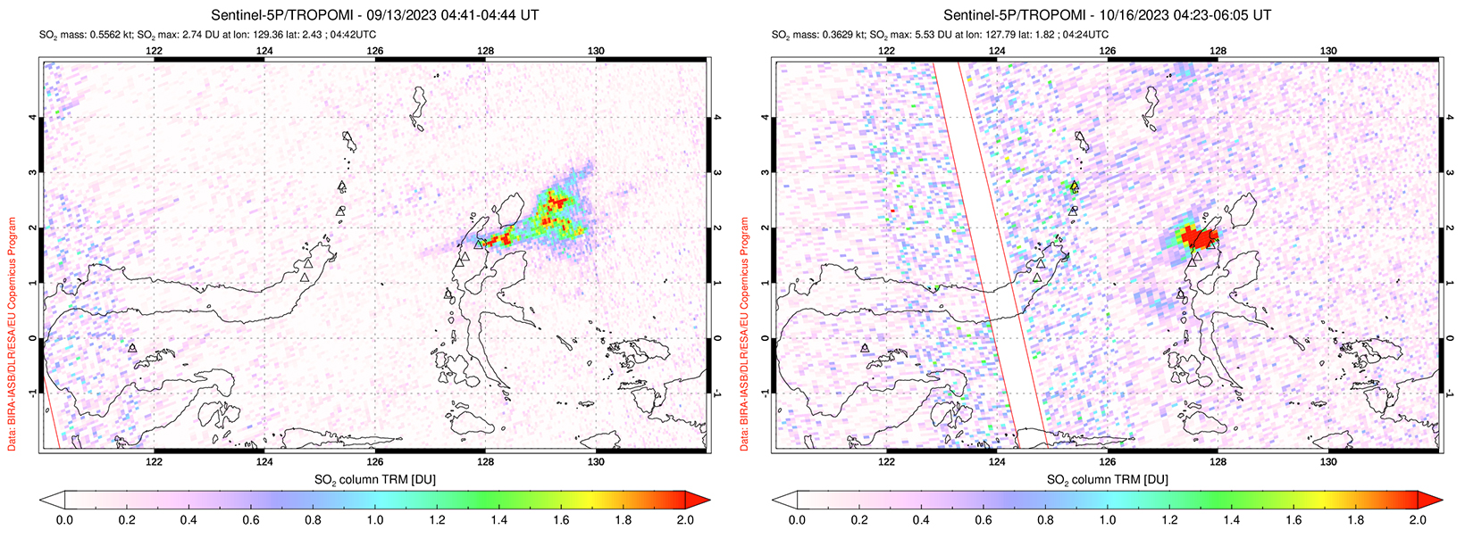
Thermal anomalies recorded by the MIROVA system were infrequent during this period except for approximately mid-October through mid-November 2023, corresponding to observations of ashfall. MODVOLC thermal alerts were recorded on 25 October, 10 November, and 15 November 2023. Weather clouds or steam plumes often prevented clear satellite views, but a distinct thermal anomaly at the center of the summit crater was observed in Sentinel-2 images on 24 June, 29 July, 7 October, 12 October, 27 October, 1 November, and 26 November. Sulfur dioxide plumes were detected by the TROPOMI instrument aboard the Sentinel-5P satellite (figure 36) on roughly half the days each month during the reporting period, with fewer in July and more in November.
Geological Summary. Reports from this remote volcano in northernmost Halmahera are rare, but Dukono has been one of Indonesia's most active volcanoes. More-or-less continuous explosive eruptions, sometimes accompanied by lava flows, have occurred since 1933. During a major eruption in 1550 CE, a lava flow filled in the strait between Halmahera and the N-flank Gunung Mamuya cone. This complex volcano presents a broad, low profile with multiple summit peaks and overlapping craters. Malupang Wariang, 1 km SW of the summit crater complex, contains a 700 x 570 m crater that has also been active during historical time.
Information Contacts: Pusat Vulkanologi dan Mitigasi Bencana Geologi (PVMBG, also known as Indonesian Center for Volcanology and Geological Hazard Mitigation, CVGHM), Jalan Diponegoro 57, Bandung 40122, Indonesia (URL: http://www.vsi.esdm.go.id/); MAGMA Indonesia (Multiplatform Application for Geohazard Mitigation and Assessment in Indonesia), Kementerian Energi dan Sumber Daya Mineral (URL: https://magma.esdm.go.id/v1); Darwin Volcanic Ash Advisory Centre (VAAC), Bureau of Meteorology, Northern Territory Regional Office, PO Box 40050, Casuarina, NT 0811, Australia (URL: http://www.bom.gov.au/info/vaac/); NASA Global Sulfur Dioxide Monitoring Page, Atmospheric Chemistry and Dynamics Laboratory, NASA Goddard Space Flight Center (NASA/GSFC), 8800 Greenbelt Road, Goddard, Maryland, USA (URL: https://so2.gsfc.nasa.gov/); Copernicus Browser, Copernicus Data Space Ecosystem, European Space Agency (URL: https://dataspace.copernicus.eu/browser/); MIROVA (Middle InfraRed Observation of Volcanic Activity), a collaborative project between the Universities of Turin and Florence (Italy) supported by the Centre for Volcanic Risk of the Italian Civil Protection Department (URL: http://www.mirovaweb.it/).


