
Smithsonian Institution
Bulletin of the Global Volcanism Network, vol. 49, no. 2 (February 2024)
Managing Editor: Kadie Bennis
Ulawun (Papua New Guinea) Significant eruption with ash plumes, lava flows, and pyroclastic flows in November 2023
Please cite this report as:
Global Volcanism Program, 2024. Report on Ulawun (Papua New Guinea) (Bennis, K L, ed.). Bulletin of the Global Volcanism Network, 49:2. Smithsonian Institution.
Ulawun is the highest volcano of the Bismarck arc on the N coast of the island of New Britain in Papua New Guinea. A prominent E-W escarpment on the south may be the result of large-scale slumping. Cones occupy the NW and E flanks. A steep-walled valley cuts the NW side, and a flank lava-flow complex lies to the south of this valley. Eruptions date back to the beginning of the 18th century. The current eruption period began in July 2023 and has been characterized by low-level seismicity, gas-and-steam and ash emissions, and minor ashfall. This report covers a significant eruption consisting of ash plumes, lava flows, and pyroclastic flows during August through December 2023 using information from the Rabaul Volcano Observatory (RVO), the Darwin Volcanic Ash Advisory Centre (VAAC), and satellite data.
Low-level activity characterized by white gas-and-steam plumes was reported during August. During 4-6 August webcam images mainly captured small-to-moderate white gas-and-steam plumes, and during 7-12 August the summit was obscured by weather clouds. Seismicity mainly consisted of volcanic tremor. Since 4 July, there had been a gradual increase in RSAM (Real-time Seismic Amplitude Measurement) levels through 12 August, which corresponded to an increase in volcanic tremor amplitudes.
During September, activity slightly increased and included crater incandescence and ash plumes. RSAM values fluctuated between 200 and 300 on 14 September, but around 1955 there was a steady and gradual increase to about 800 by 0000 on 15 September. Minor incandescence was reported at the main summit crater from Ulamona Observatory (11-12 km NW) around 2107 (local time) on 14 September, which gradually became more intense (figure 31). Webcam images showed eruption plumes drifting NE illuminated by crater incandescence. Starting around 0004 on 15 September there were brief periods when the plumes appeared darker, which RVO suggested was due to intense emissions of thicker ash clouds that drifted W and WSW. RVO could not determine the ash plume height but noted that the plumes drifted NE. Rumbling noises were also reported during the eruption. After this activity, the seismicity rate, mostly consisting of low-frequency volcanic tremor, increased and the RSAM values reached about 1,600 by 0100. Shortly before 0300 RSAM values markedly increased to 4,060; RVO reported that the rapid increase occurred during 0100-0200 (figure 32). The Alert Level Stage was raised to 2 (the second lowest level of a four-stage scale).
 |
Figure 31. Webcam image of the eruption plume and summit crater incandescence at Ulawun on the night of 14 September 2023. Courtesy of RVO (VOLCANO INFORMATION BULLETIN – No. 01-092023). |
 |
Figure 32. RSAM plots for seismic stations UULA and UULB at Ulawun during 14-16 September 2023. Note that the time axis is in UTC (UTC +10). There was a marked rise in RSAM units after 0000 on 15 September 2023, which is associated with the nighttime eruption. Courtesy of RVO (VOLCANO INFORMATION BULLETIN – No. 03-092023). |
RVO reported that ash plumes continued during 0000-0800 on 15 September and were illuminated by crater incandescence. Low-to-loud rumbling was also heard during the night. There was a decline in seismicity after 0700, which eventually reached near-background levels by 0900 (figure 32). RSAM values ranged between 200 and 450. Staff from the West New Britain (WNB) Provincial Disaster Office reported very minimal ashfall around the volcano. Webcam images from 1200 on 16 September showed weak white gas-and-steam emissions but were generally clear. No audible noises were reported. As a result, the Alert Level was lowered to Stage 1 on 19 September (the lowest level on the four-level scale). Activity remained low until 1000 on 22 September, where there was a small increase in seismicity from very low-level continuous volcano tremors to low-frequency volcanic earthquakes and short-duration, sub-continuous, volcanic tremors with increased amplitudes.
RSAM values rapidly increased after 1300 on 25 September. Another small eruption was reported during the night of 25 September. According to webcam images from 1739, a tall white-to-pale gray plume rose 4-5 km above the summit vent, accompanied by very faint crater incandescence. By 1830 incandescence was bright and distinct (figure 33). Incandescent lava fragments around the summit crater and a possible small incandescent lava flow on the N upper flank were reported. Rumbling and roaring sounds were also audible. RVO reported that the eruption had ended by 2000. During the eruption, RSAM values at the UULA station reached 6,000 units. After the eruption, seismicity dropped rapidly to very low-level small volcanic tremors.
 |
Figure 33. Webcam image of the incandescent eruption at Ulawun at 1812 on 25 September. Summit crater incandescence was accompanied by an ash plume that rose 4-5 km above the summit. Courtesy of RVO (VOLCANO INFORMATION BULLETIN – No. 06-092023). |
During October, volcanism was relatively low; the last reported eruption occurred on 25 September. RVO reported variable thin-to-thick white gas-and-steam emissions. Low-level seismicity consisting of small, continuous volcanic tremors occurred during the last week of September and into the first week of October. On 8 October, small and discrete low-frequency volcanic earthquakes and short-duration sub-continuous volcanic tremors began. Small amounts of blue gas-and-steam emissions were visible on 18 October. Seismicity continued to fluctuate throughout the month and on 28 October high-frequency earthquakes began, which was similar to the activity that preceded the eruptions on 14 and 25 September. As a result, RVO recommended that the Alert Level was raised to Stage 2.
Similar low activity was reported during November. White gas-and-steam emissions were observed during 1-2 November. Seismicity was characterized by low-level volcanic tremors and low-frequency earthquakes. A low booming noise was reported around 1945 on 1 November. Faint incandescence was visible around 2100 on 1 November and persisted until sunrise the next day. Small, low-frequency earthquakes occurring at long intervals were recorded sometime before 2300 on 1 November; an increase in both magnitude and frequency occurred after 2300 and the signal again intensified after 0800 on 2 November. During the afternoon of 2 November weak-to-moderate volumes of gray-to-brown ash were occasionally visible in clear weather. Stronger incandescence was reported during the night of 2 November (figure 34) and slightly declined around 0800 on 3 November, remaining at those levels at least through noon.
 |
Figure 34. Webcam image of the summit crater incandescence at Ulawun at 2224 (local time) on 2 October 2023. Courtesy of RVO (VOLCANO INFORMATION BULLETIN – No. 01-112023). |
During 3-18 November white gas-and-steam plumes of variable densities rose above the summit crater. Low-level booming noises were reported on 9 November. Nighttime crater incandescence was also reported, fluctuating in intensity, with the most intense episodes occurring during 10-11 November. Seismicity was at low-to-moderate levels, characterized by continuous, low-level volcanic tremors, often occurring with periods of small-to-moderate discrete low-frequency volcanic earthquakes that evolved into sub-continuous volcanic tremors.
Small ash emissions were observed on 19 November. Seismicity began to intensify at around 0200 on 20 November and again at 0930. Ash plumes increased to moderate intensities and eruption noises were heard between 1430-1500. As a result, the Alert Level was raised to Stage 3 (the second highest level on a four-level scale). The ash plumes drifted W and NW, causing ashfall in Navo (11-12 km SW). During 1530-1600 the eruption intensity increased markedly and remained at high levels. The Darwin VAAC reported that ash plumes rose as high as 9.1 km altitude at 1600 and drifted SW, based on HIMAWARI-9 satellite data. By 1630 the ash plumes had risen to 15.2 km altitude, and by 2120 they had spread 241 km W. The Alert Level was raised to Stage 4 (the highest level on a four-level scale).
Continuous ash plumes obscured the summit area and by 1800 ashfall was reported in the Ulamona Mission area. A photo taken at 1807 showed incandescent ejecta above the summit and a dark, dense ash plume rising above the crater. Significant ashfall was reported in areas to the W and NW. Roaring and booming noises continued. Residents of Ubili (9 km NW) and Ulamona Mission Station moved to Kabaya (18 km SW) and Koasa, Noau and Voluvolu residents moved to Bakada (15 km NW), and residents from Nano, Pandi, and the Pata Painave areas moved to Bialla. Video and photos posted on social media showed tall lava fountaining at the summit and a pyroclastic flow descending the NW flank. Flights into the Hoskins airport (112 km SW) were canceled.
Ash plumes continued to obscure the summit from 2200 on 20 November to 0200 on 21 November, although the eruption intensity had declined. The Darwin VAAC continued to report a sustained ash plume that rose to 15 km altitude; by 0320 on 21 November ash had drifted as far as 520 km W. By 0450 the VAAC noted that ash had reached the stratosphere, rising to 18.2 km altitude and drifting 75 km SE (figure 35) and drifting E at 0630. The ash at 15 km altitude continued to extend W. Dark and dense ash emissions rose from the summit crater during 0200-1300 but were less intense. The Alert Level was lowered to Stage 3 and RVO noted that one of the two seismic stations had stopped working at 0700, which made monitoring the eruption difficult. Low roaring and booming continued as ash fell mainly to the W and NW, affecting infrastructure and crops. RVO reported that pyroclastic flows had likely descended the N and possibly SE flanks during the early part of the eruption. Ash plumes at 1030 rose to 18.3 km altitude and extended E while a continuous ash plume rose to 15.2 km altitude and drifted 444 km WNW. Areas to the W and NW of the volcano, as well as on the upper flanks, were affected by moderate to heavy ashfall and several cm of material had accumulated on roofs. Areas to the E of the volcano were less affected. There were reports of light ashfall in Kimbe around noon.
 |
Figure 35. Photo of a significant ash plume rising from Ulawun as seen from an airplane window taken during 20-21 November 2023. Photo by Enoch Lapa. Courtesy of Reuters. |
During 1300-1400 on 21 November there was a significant reduction in ash emissions, which coincided with seismicity rapidly declining from 1,000 units just prior to 1300 to background levels. Sustained ash plumes continued, according to the Darwin VAAC and by 1630, they were rising to 12.2 km altitude and drifting W. Improved visibility showed that a new vent had opened on the SW flank and preliminary ground reports indicated that it was about 1 km SE of the main 2019 eruptive fissure vent and slightly higher in elevation of 1-1.4 km. A lava flow was active from this vent and webcam images suggested that the effusion rate was high and likely descended to 400 m elevation. Weak summit crater incandescence was also observed at around 1830, as well as on the NW flank, which may have been due to a pyroclastic flow. During 2100 on 21 November to 0600 on 22 November, the eruption returned to low levels with only minor amounts of ash emissions. By 2240 the VAAC reported that the ash plume at 18.2 km altitude was no longer visible in satellite images.
Summit crater incandescence was no longer visible by 0319 on 22 November. Around 0440 ongoing ash emissions rose to 12.2 altitude and drifted WNW. RVO reported that several puffs of small thin-to-thick gray ash plumes were visible from 0600 to just before 0800, and after weather clouds obscured the summit. Seismicity remained at background levels. The Alert Level was lowered to Stage 2. During 22-24 November occasional white-to-gray gas-and-steam and ash plumes continued to rise from the vent. The new 2023 SW fissure vent remained active through at least 24 November, with a lava flow descending an undescribed the flank. Since the main phase of the eruption ended, RSAM values were below 100 units.
According to a ReliefWeb article, the U.S. Agency for International Development (USAID) reported that the eruption resulted in five deaths and caused the evacuation of more than 16,000 people, with more affected. Ashfall from the eruption impacted oil palm trees, water sources, household gardens, and nearby properties (figure 36).
 |
Figure 36. Photo from a local resident showing the ashfall that damaged oil palm trees from the Ulawun eruption during 20-21 November 2023. Courtesy of Jessica Kuambu. |
Activity during December was relatively low and occasionally consisted of white gas-and-steam plumes of variable densities rising from the summit crater. On 19 December, though visibility was poor, observers noted brown-tinged gas-and-steam plumes during a period of clear weather. On 31 December residents from Noau Village photographed dense brown ash plumes that rose a few hundred meters above the summit and drifted W. A small pyroclastic flow descended the NNE flank. According to the Darwin VAAC, a webcam image also showed a pyroclastic flow descended an undescribed flank at 1230 on 31 December. An ash plume possibly rose to 2.7 km altitude and drifted NE based on similar previous plumes and weather models, though weather clouds prevented clear satellite views.
Satellite data. Infrared satellite data showed a thermal anomaly at the summit crater during September and November 2023 (figure 37); although most times, weather conditions prevented clear views of the summit. MIROVA (Middle InfraRed Observation of Volcanic Activity) analysis of MODIS satellite data showed a notable peak in thermal activity during November due to an increase in the intensity of crater incandescence, which led up to the 20-21 November eruption (figure 38). After the eruption, activity returned to background levels. According to data from the TROPOMI instrument on the Sentinel-5P satellite, there was a significant sulfur dioxide plume with a mass of 105 kt that drifted W over the volcano (figure 39). This activity coincided with the 20-21 November eruption.
 |
Figure 37. Infrared (bands B12, B11, B4) satellite images showed a thermal anomaly at the summit crater of Ulawun on 17 September 2023 (top left), 27 September 2023 (top right), 6 November 2023 (bottom left), and 11 November 2023 (bottom right). Weather conditions often obscured clear views of the summit during the other reporting months. Courtesy of Copernicus Browser. |
 |
Figure 38. Strong and frequent thermal activity was detected at Ulawun during November 2023, based on this MIROVA plot (Log Radiative Power). This activity reflected the increase in summit crater incandescence throughout the month, culminating to a significant eruption during 20-21 November. After this event, thermal activity was no longer detected. Courtesy of MIROVA. |
 |
Figure 39. Sentinel-5P/TROPOMI data showing a significant sulfur dioxide plume rising above Ulawun (triangle) on 21 November 2023 due to an intense eruption event. This satellite image was taken at 1304 (local). There was roughly 0.1-0.15 Tg in the plume at 1305 (local). Courtesy of NASA Global Sulfur Dioxide Monitoring Page. |
Information Contacts: Rabaul Volcano Observatory (RVO), Geohazards Management Division, Department of Mineral Policy and Geohazards Management (DMPGM), PO Box 3386, Kokopo, East New Britain Province, Papua New Guinea; Darwin Volcanic Ash Advisory Centre (VAAC), Bureau of Meteorology, Northern Territory Regional Office, PO Box 40050, Casuarina, NT 0811, Australia (URL: http://www.bom.gov.au/info/vaac/); Global Sulfur Dioxide Monitoring Page, Atmospheric Chemistry and Dynamics Laboratory, NASA Goddard Space Flight Center (NASA/GSFC), 8800 Greenbelt Road, Goddard, Maryland, USA (URL: https://SO2.gsfc.nasa.gov/); Copernicus Browser, Copernicus Data Space Ecosystem, European Space Agency (URL: https://dataspace.copernicus.eu/browser/); Al Jazeera, Papua New Guinea cancels flights, plans evacuation after volcano erupts (https://www.aljazeera.com/news/2023/11/21/papua-new-guinea-cancels-flights-plans-evacuation-after-volcano-erupts); ReliefWeb, The United States provides immediate emergency assistance to support communities affected by Mount Ulawun volcanic eruptions (https://reliefweb.int/report/papua-new-guinea/united-states-provides-immediate-emergency-assistance-support-communities-affected-mount-ulawun-volcanic-eruptions); Reuters, Flights cancelled, residents to evacuate as Papua New Guinea volcano erupts (http://www.reuters.com/); RNZ, Thousands evacuated in Papua New Guinea after Mt Ulawun erupts (https://www.rnz.co.nz/international/pacific-news/503071/thousands-evacuated-in-papua-new-guinea-after-mt-ulawun-erupts); Jessica Kuambu (URL: https://x.com/jessica_kuambu); Lekei Kilala (URL: https://x.com/LekeiKilala).
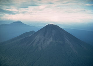
Geological Summary. The symmetrical basaltic-to-andesitic Ulawun stratovolcano is the highest volcano of the Bismarck arc, and one of Papua New Guinea's most frequently active. The volcano, also known as the Father, rises above the N coast of the island of New Britain across a low saddle NE of Bamus volcano, the South Son. The upper 1,000 m is unvegetated. A prominent E-W escarpment on the south may be the result of large-scale slumping. Satellitic cones occupy the NW and E flanks. A steep-walled valley cuts the NW side, and a flank lava-flow complex lies to the south of this valley. Historical eruptions date back to the beginning of the 18th century. Twentieth-century eruptions were mildly explosive until 1967, but after 1970 several larger eruptions produced lava flows and basaltic pyroclastic flows, greatly modifying the summit crater.


 Ulawun