Report on Fuss Peak (Russia) — April 1987
Scientific Event Alert Network Bulletin, vol. 12, no. 4 (April 1987)
Managing Editor: Lindsay McClelland.
Fuss Peak (Russia) Moderate fumarolic activity
Please cite this report as:
Global Volcanism Program, 1987. Report on Fuss Peak (Russia) (McClelland, L., ed.). Scientific Event Alert Network Bulletin, 12:4. Smithsonian Institution. https://doi.org/10.5479/si.GVP.SEAN198704-290340
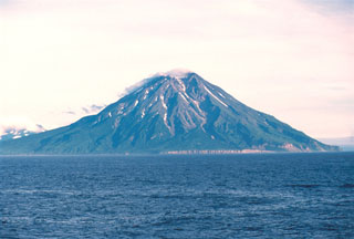
Fuss Peak
Russia
50.267°N, 155.246°E; summit elev. 1742 m
All times are local (unless otherwise noted)
Between 12 October and 2 November 1986, moderate fumarolic activity was observed in the E part of the summit crater. The fumaroles fell along a N-S line that divided the crater. The rest of the crater was snow-covered.
Geological Summary. Fuss Peak forms a peninsula that lies across a low isthmus on the SW coast of Paramushir Island in the northern Kuriles. This isolated symmetrical andesitic stratovolcano has a 700-m-wide, steep-walled crater that is 300 m deep. A deep notch cuts the NW rim of the crater to the level of the crater floor, at the head of a canyon that reaches the coast. Well-preserved lava flows occupy the middle and lower flanks, particularly on the E and SE sides. Only one unambiguous recorded eruption, in 1854 CE, is known; reports of eruptions in 1737, 1793, 1857, and 1859 are false (Gorshkov, 1970). Murayama (1987) also listed an eruption in 1742 (only earthquakes and a tsunami are cited by Sapper, 1917) and "smoke" emission in 1933.
Information Contacts: G. Steinberg and B. Piskunov, Yuzhno-Sakhalinsk.