Report on Home Reef (Tonga) — November 2022
Bulletin of the Global Volcanism Network, vol. 47, no. 11 (November 2022)
Managing Editor: Edward Venzke.
Edited by Kadie L. Bennis.
Home Reef (Tonga) New island-forming eruption with ash plumes during September-October 2022
Please cite this report as:
Global Volcanism Program, 2022. Report on Home Reef (Tonga) (Bennis, K.L., and Venzke, E., eds.). Bulletin of the Global Volcanism Network, 47:11. Smithsonian Institution.
Home Reef
Tonga
18.992°S, 174.775°W; summit elev. -10 m
All times are local (unless otherwise noted)
Home Reef is a submarine volcano located in the central Tonga islands between Lateiki (Metis Shoal) and Late Island. The first recorded eruption occurred in the mid-19th century, when an ephemeral island formed. An eruption in 1984 produced a 12-km-high eruption plume, a large volume of floating pumice, and an ephemeral island 500 x 1,500 m wide, with cliffs 30-50 m high that enclosed a water-filled crater. Another island-forming eruption in 2006 produced widespread pumice rafts that drifted as far as Australia; by 2008 the island had eroded below sea level. Activity during November 2008 included a hydrothermal plume in addition to discolored water that spanned roughly 1-2 km2 (BGVN 33:12). This report covers a new island-forming eruption during 10 September through 17 October 2022 that consisted of lava effusion, ash plumes, discolored water, and gas-and-steam plumes using information from the Tonga Geological Services (TGS) and satellite data.
Starting on 22 May 2022 up until the start of the new eruption in early September 2022, discolored water plumes were visible in Sentinel-2 satellite images on clear weather days that originated from a single point (figure 26). Water discoloration was yellow-green in color and extended in different directions.
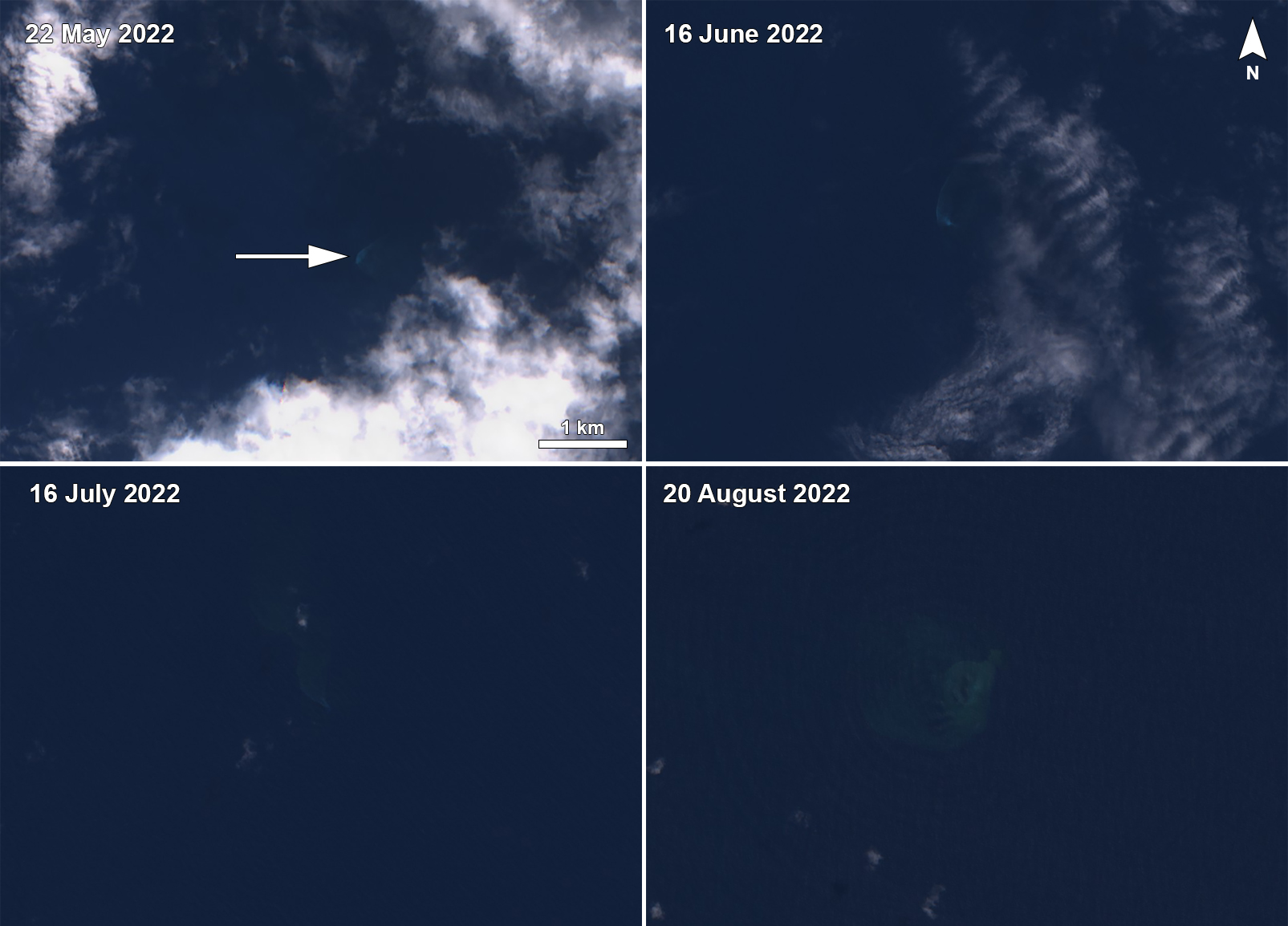 |
Figure 26. Sentinel-2 satellite images showing light yellow-green discolored plumes originating from a single point (white arrow) at Home Reef during 22 May 2022 (top left), 16 June 2022 (top right), 16 July 2022 (bottom left), and 20 August 2022 (bottom right). Images using “Natural Color” rendering (bands 4, 3, 2). Courtesy of Sentinel Hub Playground. |
According to the Volcano Watch Team from the TGS, the summit rose above sea level at 0139 on 10 September 2022, based on a volcanic gas plume that was detected in satellite images (figure 27). Then, at 1259 a Sentinel-2 satellite image showed a small island about 70 m in diameter and an estimated 10 m above the ocean surface due to lava effusion. The new island was consistently surrounded by yellow-green discolored water (figure 28). Near-daily gas-and-steam emissions mostly rose to 1 km altitude and rose as high as 2 km altitude. Hydrothermal submarine activity was detected during 12-13 September, and a thermal anomaly was identified in a satellite image acquired at 1400 on 13 September. Thermal activity was captured in HIMAWARI-8 satellite imagery at 1340 on 14 September, at 0730 on 15 September, and at 0220 on 16 September. By 16 September the island had grown to 170 m in diameter and reached 182 m N-S and 173 m E-W by 18 September (figure 29).
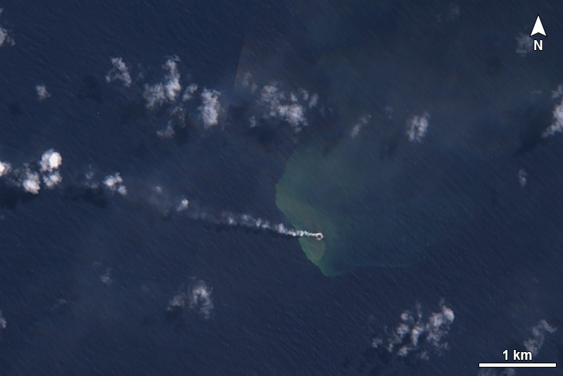 |
Figure 27. Sentinel-2 satellite image showing the emergence of a new island (black circle) at Home Reef on 9 September 2022 (UTC time). A gas-and-steam plume drifts W, with distinct yellow-green discolored submarine plumes surrounding the island and dispersing generally NE. Image using “Natural Color” rendering (bands 4, 3, 2). Courtesy of Sentinel Hub Playground. |
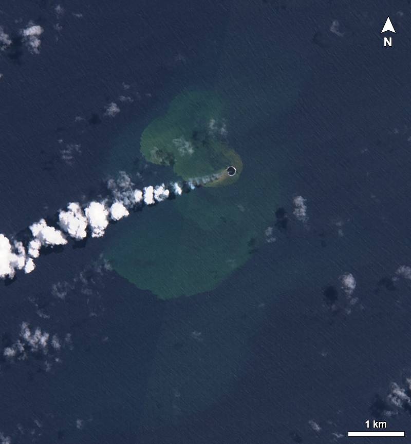 |
Figure 28. Sentinel-2 satellite image showing the new island that emerged at Home Reef taken on 14 September 2022 (UTC time). The island (black circle) is 170 m in diameter and yellow-green discolored water surrounds the island. Distinct gas-and-steam plumes are also visible drifting SW. Image using “Natural Color” rendering (bands 4, 3, 2). Courtesy of Sentinel Hub Playground. |
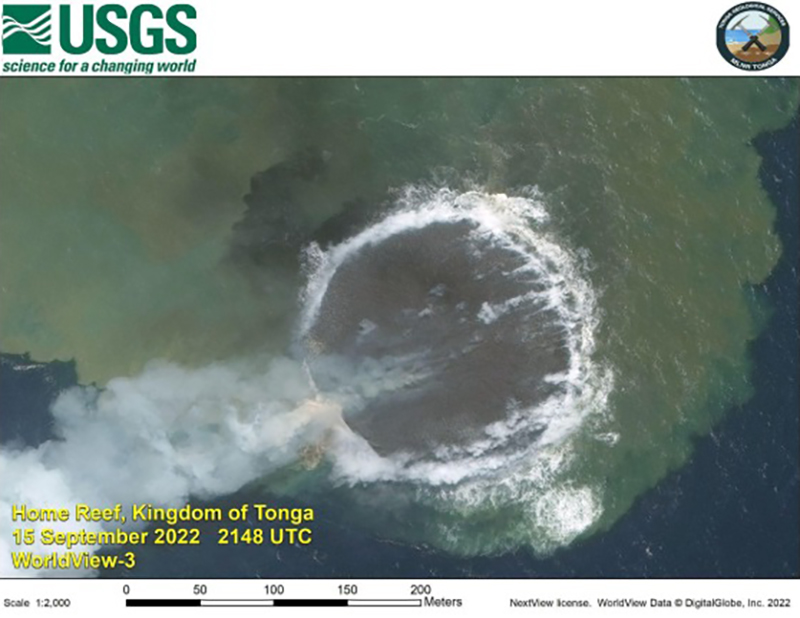 |
Figure 29. Worldview-3 satellite image acquired at 2148 (UTC time) on 15 September 2022 showing the lava surface of the newly emerged island at Home Reef. The island measured 182 m N-S and 173 m E-W. Strong white gas-and-steam emissions and yellow-green discolored water surround the newly formed island. A fumarolic plume drifts W. Courtesy of USGS and Tonga Geological Services. |
During 19-20 September gas-and-steam plumes containing some amount of ash rose to 3 km above sea level (figure 30). New measurements made on 19 September showed that the island had grown to 211 m N-S and 218 m E-W and was an estimated height of 15 m above sea level. During 0040-0250 on 25 September gas-and-ash plumes rose to 2-4 km altitude and drifted 30 km W, S, and SE. At 0030 on 27 September an ash plume rose to 6-8 km altitude and drifted 25 km SSE. On 28 September the island was 268 m N-S, 283 m E-W, and 15-18 m above sea level. Discolored water plumes continued to circulate the island within about 200 m from the shore and generally drifted S due to the current direction. Ash was no longer detected in the eruptive plumes on 29 September, and according to a Skysat satellite, the volcanic plume thinned within 1 km of the island.
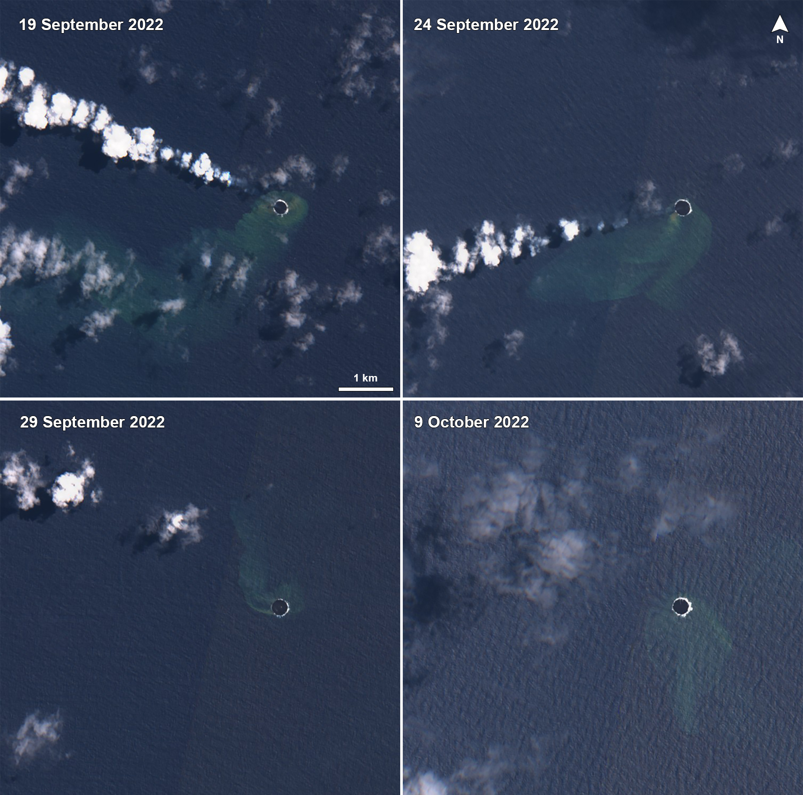 |
Figure 30. Sentinel-2 satellite images showing the evolution of the new island (black circle) at Home Reef due to persistent lava effusion during 19 September 2022 (top left), 24 September 2022 (top right), 29 September 2022 (bottom left), and 9 October 2022 (bottom right). White gas-and-steam emissions sometimes containing ash were occasionally visible and drifted NW and SW, as shown on 19 and 24 September, respectively. Yellow-green discolored water was also observed surrounding the island and extending to the SW, W, and N. Images using “Natural Color” rendering (bands 4, 3, 2). Courtesy of Sentinel Hub Playground. |
Eruptive activity continued during October, with persistent lava effusion, fumarolic activity, and discolored water areas. On 5 October at 0036 an ash plume rose to 3 km altitude and drifted 5 km SE. Satellite imagery showed that the island had not grown on 10 October, with measurements of 268 m N-S and 283 m E-W, and an estimated height of 15-18 m. An ash plume was visible at 0040 on 6 October that rose to 3 km altitude and drifted 5 km SE. A thermal anomaly was detected in satellite imagery at 0146 on 17 October; TGS reported on 22 October that the anomaly on the 17th was the last recorded activity.
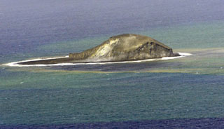
Geological Summary. Home Reef, a submarine volcano midway between Metis Shoal and Late Island in the central Tonga islands, was first reported active in the mid-19th century, when an ephemeral island formed. An eruption in 1984 produced a 12-km-high eruption plume, large amounts of floating pumice, and an ephemeral 500 x 1,500 m island, with cliffs 30-50 m high that enclosed a water-filled crater. In 2006 an island-forming eruption produced widespread dacitic pumice rafts that drifted as far as Australia. Another island was built during a September-October 2022 eruption.
Information Contacts: Tonga Geological Services, 51 Vaha'akolo Road, Nuku’alofa, Tonga (URL: https://www.facebook.com/tongageologicalservice); US Geological Survey, Volcano Hazards Program (USGS-VHP), 12201 Sunrise Valley Drive, Reston, VA, USA, https://volcanoes.usgs.gov/index.html; Sentinel Hub Playground (URL: https://www.sentinel-hub.com/explore/sentinel-playground).