Report on Erta Ale (Ethiopia) — 24 November-30 November 2010
Smithsonian Institution / US Geological Survey
Weekly Volcanic Activity Report, 24 November-30 November 2010
Managing Editor: Sally Sennert.
Please cite this report as:
Global Volcanism Program, 2010. Report on Erta Ale (Ethiopia) (Sennert, S, ed.). Weekly Volcanic Activity Report, 24 November-30 November 2010. Smithsonian Institution and US Geological Survey.
Erta Ale
Ethiopia
13.601°N, 40.666°E; summit elev. 585 m
All times are local (unless otherwise noted)
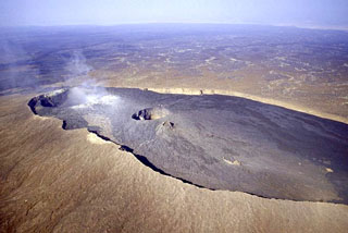
Scientists from the Afar Consortium Project observed the lava lake at Erta Ale during 21-23 November. They noted Strombolian activity from the lava lake in the southern pit crater. The lava lake had filled the pit crater and breached the W rim, spilling two lava flows into the main crater. The lava lake was encompassed by a scoria ring that was about 4 m high on the S side. By 23 November, the lake was above the scientist's eye level when they stood W of the southern pit in the main crater.
Geological Summary. The Erta Ale basaltic shield volcano in Ethiopia has a 50-km-wide edifice that rises more than 600 m from below sea level in the Danakil depression. The volcano includes a 0.7 x 1.6 km summit crater hosting steep-sided pit craters. Another larger 1.8 x 3.1 km wide depression elongated parallel to the trend of the Erta Ale range is located SE of the summit and is bounded by curvilinear fault scarps on the SE side. Basaltic lava flows from these fissures have poured into the caldera and locally overflowed its rim. The summit caldera usually also holds at least one long-term lava lake that has been active since at least 1967, and possibly since 1906. Recent fissure eruptions have occurred on the N flank.
Source: Afar Rift Consortium