Report on Dieng Volcanic Complex (Indonesia) — 1 June-7 June 2011
Smithsonian Institution / US Geological Survey
Weekly Volcanic Activity Report, 1 June-7 June 2011
Managing Editor: Sally Sennert.
Please cite this report as:
Global Volcanism Program, 2011. Report on Dieng Volcanic Complex (Indonesia) (Sennert, S, ed.). Weekly Volcanic Activity Report, 1 June-7 June 2011. Smithsonian Institution and US Geological Survey.
Dieng Volcanic Complex
Indonesia
7.2°S, 109.879°E; summit elev. 2565 m
All times are local (unless otherwise noted)
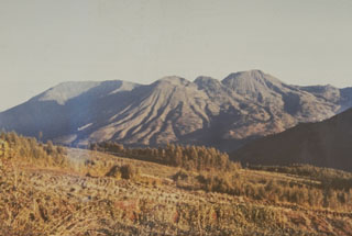
CVGHM reported that during 29 May-5 June carbon dioxide gas emissions from Timbang, a cone that is part of the Dieng Volcanic Complex, remained elevated. Seismicity for Dieng also remained high. During 4-5 June white plumes from Sileri crater rose 20-60 m high and white plumes from Timbang rose only 2 m and drifted 300 m S. The Alert Level remained at 3 (on a scale of 1-4).
Geological Summary. The Dieng plateau in the highlands of central Java is renowned both for the variety of its volcanic scenery and as a sacred area housing Java's oldest Hindu temples, dating back to the 9th century CE. The Dieng Volcanic Complex consists of multiple stratovolcanoes and more than 20 small Pleistocene-to-Holocene craters and cones over a 6 x 14 km area. Prahu stratovolcano was truncated by a large Pleistocene caldera, which was subsequently filled by a series of cones, lava domes, and craters, many containing lakes. Lava flows cover much of the plateau, but observed activity has been restricted to minor phreatic eruptions. Gas emissions are a hazard at several craters and have caused fatalities. There are abundant thermal features and high heat flow across the area.
Source: Pusat Vulkanologi dan Mitigasi Bencana Geologi (PVMBG, also known as CVGHM)