Report on Puyehue-Cordon Caulle (Chile) — 1 June-7 June 2011
Smithsonian Institution / US Geological Survey
Weekly Volcanic Activity Report, 1 June-7 June 2011
Managing Editor: Sally Sennert.
Please cite this report as:
Global Volcanism Program, 2011. Report on Puyehue-Cordon Caulle (Chile) (Sennert, S, ed.). Weekly Volcanic Activity Report, 1 June-7 June 2011. Smithsonian Institution and US Geological Survey.
Puyehue-Cordon Caulle
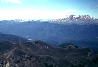
Chile
40.59°S, 72.117°W; summit elev. 2236 m
All times are local (unless otherwise noted)
OVDAS-SERNAGEOMIN reported that between 2000 on 2 June and 1959 on 3 June about 1,450 earthquakes at Puyehue-Cordón Caulle were detected, or an average of about 60 earthquakes per hour. The earthquakes were mostly hybrid and long-period, and located in the SE sector of the Cordón Caulle rift zone at depths of 2-5 km. SERNAGEOMIN scientists along with regional authorities flew over the volcano, noting no significant changes. The Alert Level remained at 4, Yellow. Area residents reported feeling earthquakes during the evening of 3 June through the morning of 4 June.
For a six-hour period on 4 June, seismicity increased to an average of 230 earthquakes per hour, at depths of 1-4 km. About 12 events were magnitudes greater than 4, and 50 events were magnitudes greater than 3. The Alert Level was raised to 5, Red. ONEMI reported that the border crossing into Argentina was closed and about 700 local people were to start evacuating. Later, an explosion from Cordón Caulle produced a 5-km-wide ash-and-gas plume that rose to an altitude of 12.2 km (40,000 ft) a.s.l. as noted by OVDAS scientists. The plume drifted S at 5 km altitude, and W and E at 10 km altitude. The Alert Level was raised to 6, Red. ONEMI reported the continuation of evacuations and increased the potential number of evacuees to 3,000. ONEMI also reported that the National Director of SERNAGEOMIN noted that lava was not detected, but pyroclastic flow deposits were observed. Residents reported a strong sulfur odor and significant ash and pumice fall. During 4-5 June ashfall several centimeters thick was reported in San Carlos de Bariloche, 100 km SE in Argentina, and surrounding areas.
Based on analyses of satellite imagery, SIGMET notices, and information from the Puerto Montt Flight Information Region (FIR), the Buenos Aires VAAC reported that on 4 June ash plumes rose to altitudes of 10.7-13.7 km (35,000-45,000 ft) a.s.l. and drifted 870 km ESE. Diffuse gas-and-steam plumes drifted W. The next day an ash plume continued to rise to altitudes of 10.7-12.2 km (35,000-40,000 ft) a.s.l. and had drifted as far as 1,778 km ESE, over the coast of Argentina, and out into the Atlantic Ocean. A portion of the plume drifted WSW. News outlets reported that flights in southern Argentina were canceled during 4-5 June. On 6 June the continuous ash plume changed direction and was blown ENE as far as 178 km while the previous portion of the plume continued to drift ESE over the ocean. On 7 June the VAAC reported continuous emissions. Ash plumes rose to altitudes of 5.5-9.8 km (18,000-32,000 ft) a.s.l. and were 65-95 km wide. A large area of ash continued to drift E over the Atlantic Ocean. News articles noted that some flights in Paraguay and Chile were cancelled and about 4,000 people had evacuated. News photos showed ashfall and people collecting pumice in San Martin de los Andes, Argentina, 80 km NE.
Geological Summary. The Puyehue-Cordón Caulle volcanic complex (PCCVC) is a large NW-SE-trending late-Pleistocene to Holocene basaltic-to-rhyolitic transverse volcanic chain SE of Lago Ranco. The 1799-m-high Pleistocene Cordillera Nevada caldera lies at the NW end, separated from Puyehue stratovolcano at the SE end by the Cordón Caulle fissure complex. The Pleistocene Mencheca volcano with Holocene flank cones lies NE of Puyehue. The basaltic-to-rhyolitic Puyehue volcano is the most geochemically diverse of the PCCVC. The flat-topped, 2236-m-high volcano was constructed above a 5-km-wide caldera and is capped by a 2.4-km-wide Holocene summit caldera. Lava flows and domes of mostly rhyolitic composition are found on the E flank. Historical eruptions originally attributed to Puyehue, including major eruptions in 1921-22 and 1960, are now known to be from the Cordón Caulle rift zone. The Cordón Caulle geothermal area, occupying a 6 x 13 km wide volcano-tectonic depression, is the largest active geothermal area of the southern Andes volcanic zone.
Sources: Oficina Nacional de Emergencia-Ministerio del Interior (ONEMI), Buenos Aires Volcanic Ash Advisory Center (VAAC), Servicio Nacional de Geología y Minería (SERNAGEOMIN), NASA Earth Observatory, La Tercera News