Report on Tolbachik (Russia) — 21 November-27 November 2012
Smithsonian Institution / US Geological Survey
Weekly Volcanic Activity Report, 21 November-27 November 2012
Managing Editor: Sally Sennert.
Please cite this report as:
Global Volcanism Program, 2012. Report on Tolbachik (Russia) (Sennert, S, ed.). Weekly Volcanic Activity Report, 21 November-27 November 2012. Smithsonian Institution and US Geological Survey.
Tolbachik
Russia
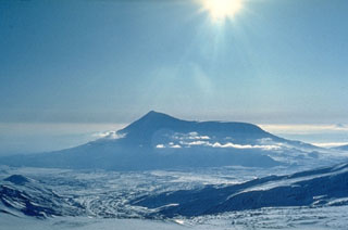
55.832°N, 160.326°E; summit elev. 3611 m
All times are local (unless otherwise noted)
KVERT reported that episodes of volcanic tremor were detected in the area of Plosky Tolbachik during 7-10, 18, and 26 November. The number of shallow volcanic earthquakes increased to 250 on 26 November. A strong event occurred at 1652 on 27 November. The Aviation Color Code was raised to Yellow. That same day observers from Kozyrevsk (40 km NW) and Lazo (50 km SW) villages reported ash explosions and lava flows at Tolbachinsky Dol, in the same area as the 1975 eruption (northern vents). Ashfall, 4 cm thick, was reported in Krasny Yar (60 km NNW). The Aviation Color Code was raised to Orange. Based on information from the Kamchatka Branch of Geophysical Services (KGBS), the Tokyo VAAC reported that ash plumes possibly rose to altitudes of 6.1-10.1 km (20,000-33,000 ft) a.s.l. Ash plumes were not detected in satellite imagery. Plume altitudes were estimated based on seismic data.
Geological Summary. The massive Tolbachik volcano is located at the southern end of the Kliuchevskaya volcano group. The massif is composed of two overlapping, but morphologically distinct, volcanoes. The flat-topped Plosky Tolbachik shield volcano with its nested Holocene calderas up to 3 km in diameter is located east of the older and higher sharp-topped Ostry Tolbachik stratovolcano. The summit caldera at Plosky Tolbachik was formed in association with major lava effusion about 6,500 years ago and simultaneously with a major southward-directed sector collapse of Ostry Tolbachik. Long rift zones extending NE and SSW of the volcano have erupted voluminous basaltic lava flows during the Holocene, with activity during the past two thousand years being confined to the narrow axial zone of the rifts. The 1975-76 eruption originating from the SSW-flank fissure system and the summit was the largest historical basaltic eruption in Kamchatka.
Sources: Tokyo Volcanic Ash Advisory Center (VAAC), Kamchatkan Volcanic Eruption Response Team (KVERT)